Mori Atlas logo
Wildlife reserveHunting Camp Creek Wilderness

A remote forest corridor featuring deep valleys and Appalachian Trail segments in Bland County

Hunting Camp Creek Wilderness Protected Landscape and Appalachian Ridge Geography

Hunting Camp Creek Wilderness represents a significant protected area within the central Appalachian Mountains of southwestern Virginia. Spanning over 8,000 acres in Bland County, this wildlife reserve contains forested ridges, narrow stream valleys, and vital wetlands. The mapped terrain includes Garden Mountain and Brushy Mountain, providing a rugged setting for deep-forest biodiversity and continuous backcountry trail corridors.

wilderness areaAppalachian TrailAppalachian Mountainsridge and valleyold-growth forestbackcountry hiking

Hunting Camp Creek Wilderness

Wildlife reserve

Park overview

Structured park overview, official facts, and landscape profile for Hunting Camp Creek Wilderness

Hunting Camp Creek Wilderness park facts, protected area profile, and essential visitor context

Review the core facts for Hunting Camp Creek Wilderness, including designation, size, terrain, visitor scale, habitats, and operating context in one park-focused overview.

About Hunting Camp Creek Wilderness

Hunting Camp Creek Wilderness occupies a rugged, roadless portion of the Ridge and Valley region of the central Appalachians in southwestern Virginia. The wilderness surrounds two creek drainages, Hunting Camp Creek and Little Wolf Creek, set between the long ridgelines of Garden Mountain and Brushy Mountain. This setting places it on the outer flank of an ancient dome-shaped geologic structure whose erosion has exposed both the steep ridges and the limestone-rich bowl of Burkes Garden to the north.

Designated by Congress in 2009 under the Eastern Wilderness Act, Hunting Camp Creek joined the National Wilderness Preservation System to preserve its natural condition and ecological diversity. Although modest in size compared to western U.S. wilderness areas, it plays an important role in eastern wilderness conservation, helping to maintain forest communities, biodiversity, and habitat connectivity in a region with extensive human land-use history. The U.S. Forest Service administers the area through the Eastern Divide Ranger District of the George Washington and Jefferson National Forests.

A defining feature of the wilderness is its nearly ten-mile Appalachian Trail corridor, which traverses the wildest and most remote country in this section of the southern Appalachians. The trail follows the crest of Garden Mountain before descending toward the surrounding lowlands, giving hikers sweeping vistas across Burkes Garden and a sense of deep isolation. Limited roads, abandoned logging roads, an old railroad grade, and a low-impact blue-blazed side trail along Wolf Creek provide additional but still rugged routes into the interior.

Ecologically, the wilderness stands out for its forest variety, stream-driven wildflower abundance, possible old-growth stands, and the protected habitats of the Little Wolf Creek Primitive Management Area. The combination of high biodiversity, trail-based recreation, and strict wilderness protections makes Hunting Camp Creek a quiet but ecologically valuable anchor within the Garden Mountain Cluster.

Quick facts and research context for Hunting Camp Creek Wilderness

Hunting Camp Creek Wilderness is an 8,471-acre federally designated wilderness in Bland County, Virginia, managed by the U.S. Forest Service as part of the George Washington and Jefferson National Forests. Created in 2009 under the Eastern Wilderness Act, it falls within the Garden Mountain Cluster and is classified as IUCN Category Ib. The wilderness spans two remote watersheds crossed by a 9.7-mile section of the Appalachian Trail, and elevations rise from about 2,380 feet along Hunting Camp Creek to roughly 4,120 feet on Garden Mountain.

Park context

Deeper park guide and search-rich context for Hunting Camp Creek Wilderness

Hunting Camp Creek Wilderness history, landscape, wildlife, and travel context

Explore Hunting Camp Creek Wilderness through its history, landscape character, ecosystems, wildlife, conservation priorities, cultural context, and seasonal travel timing in a structured park guide built for atlas discovery and search intent.

Why Hunting Camp Creek Wilderness stands out

Hunting Camp Creek Wilderness is best known for its exceptionally wild stretch of the Appalachian Trail along Garden Mountain, where hikers can look down into the bowl-shaped Burkes Garden. It is also recognized for the botanical richness of its stream valleys, including rare plants such as roundleaf goldenrod, fringed gentian, and Fraser's sedge, and for the high bird diversity of the Little Wolf Creek Primitive Management Area.

Hunting Camp Creek Wilderness history and protected-area timeline

Hunting Camp Creek Wilderness was formally established in 2009 when Congress designated it under the Eastern Wilderness Act, adding its 8,471 acres to the National Wilderness Preservation System. The designation aimed to preserve the area in its natural condition and to recognize its contribution to biodiversity conservation in the eastern United States.

It is administered by the U.S. Forest Service as part of the Eastern Divide Ranger District within the George Washington and Jefferson National Forests, and it belongs to the broader Garden Mountain Cluster, a grouping of nearby wilderness-quality lands. While the area had a history of timber cutting and railroad use, judging by the presence of abandoned logging roads and an old rail grade, its formal protection marks a shift toward long-term conservation and low-impact recreation rather than resource extraction.

Hunting Camp Creek Wilderness landscape and geographic character

The landscape of Hunting Camp Creek Wilderness is shaped by two principal ridges, Garden Mountain and Brushy Mountain, which stand as long, forested spines along the western and eastern sides of the area. Between them lie deep, narrow creek valleys carved by Hunting Camp Creek and Little Wolf Creek, with additional smaller drainages such as Wolf Creek and Laurel Creek along the edges. This terrain belongs to the Ridge and Valley section of the central Appalachians, a region defined by repeating ridges of sandstone and shale separated by softer shale valleys.

Elevations climb from about 2,380 feet where Hunting Camp Creek flows at its lowest to roughly 4,120 feet along the crest of Garden Mountain, producing a noticeable gradient from moist, sheltered valley bottoms to drier, exposed ridge lines. Steep slopes feed a high density of small streams into the creek valleys, contributing to the dense, moist forest character of the hollows.

The broader geological context adds to the wilderness visual drama. The area sits on the outer flank of an ancient, dome-like geologic uplift that has eroded over millions of years, leaving behind the steep flanks that hikers now travel along. Inside that eroded dome lies Burkes Garden, an oval basin of older limestone soils visible from Garden Mountain. From the Appalachian Trail on Garden Mountain, hikers obtain a sweeping, unobstructed view across the bowl-shaped Burkes Garden, one of the defining scenic experiences of the wilderness.

Hunting Camp Creek Wilderness ecosystems, habitats, and plant life

Hunting Camp Creek Wilderness contains a rich mosaic of Appalachian forest communities, shaped strongly by slope, elevation, and moisture. In the valley bottoms along Hunting Camp Creek and Wolf Creek, mesic hardwood forests of white oak, tulip poplar, sugar maple, basswood, Fraser magnolia, and white pine dominate, while the drier, exposed ridge crests of Brushy Mountain and Garden Mountain support more drought-tolerant chestnut oak and hickory stands. Scattered through the landscape are approximately 522 acres of possible old-growth forest, adding structural complexity and biological value.

A distinctive feature is the Little Wolf Creek Primitive Management Area, a roughly 500-acre section within the wilderness where acidic and alkaline soils intermingle. This unusual soil chemistry supports a particularly rich understory of ferns and flowering plants, including New York fern, lady fern, Canada violet, wood nettle, foam flower, and black cohosh. Rare species such as roundleaf goldenrod, fringed gentian, and Fraser's sedge also occur here. Beaver ponds in the upper Hunting Camp Creek wetlands add another habitat layer, supporting cinnamon fern, red catchfly, Indian physic, columbine, and flame azalea.

Hunting Camp Creek Wilderness wildlife and species highlights

Wildlife in Hunting Camp Creek Wilderness reflects the diversity of habitats sheltered within its valleys and ridges. The Little Wolf Creek Primitive Management Area in particular is recognized for its birdlife, hosting 33 documented bird species, including 10 species of warblers and 2 species of orioles, making it a notable stop for birdwatchers. The mix of mature forest, wetland edges, and beaver ponds supports a varied songbird community typical of the southern Appalachians.

In the streams and ponds, the imperiled Tennessee dace, a small, strikingly orange-colored fish, finds suitable habitat, especially in spring-fed ponds below seepage areas. The presence of beavers and their associated wetlands further increases habitat diversity for amphibians, aquatic invertebrates, and small mammals, while the surrounding mature forest supports broader Appalachian wildlife communities, even though most larger species are not emphasized in the available source material.

Hunting Camp Creek Wilderness conservation status and protection priorities

Hunting Camp Creek Wilderness was designated under the Eastern Wilderness Act to keep the area in its present natural condition and to protect its ecological diversity. As part of the National Wilderness Preservation System, it contributes to conserving native plant and animal communities, maintaining old-growth forest characteristics, and strengthening the broader Garden Mountain Cluster of protected lands.

The wilderness protections are more than symbolic. Motorized equipment, motor vehicles, and mountain bikes are prohibited, group sizes are limited to ten people, and camping is regulated to reduce human impact. These restrictions help preserve the area's quiet, its forest integrity, and the conditions that support its sensitive species, including rare plants like roundleaf goldenrod, fringed gentian, and Fraser's sedge, and the imperiled Tennessee dace. Within the larger landscape of southwestern Virginia, where much of the surrounding land has a long history of resource use, Hunting Camp Creek functions as a relatively undisturbed refuge for Appalachian biodiversity.

Top sights and standout views in Hunting Camp Creek Wilderness

Hunting Camp Creek Wilderness stands out for the combination of a remote Appalachian Trail corridor, deep creek-cut valleys, and ecologically rich forest and wetland communities within a relatively compact area. The nearly uninterrupted view across Burkes Garden from Garden Mountain, the botanical richness of the Little Wolf Creek Primitive Management Area, and the presence of possible old-growth forest are among the wilderness's most distinctive qualities.

Best time to visit Hunting Camp Creek Wilderness

Spring and early summer are particularly rewarding times to experience Hunting Camp Creek Wilderness, when wildflowers are at their peak in the valley bottoms and the birdlife in the Little Wolf Creek Primitive Management Area is most active. Fall brings cooler temperatures, vibrant hardwood color along the ridges and valleys, and a quieter atmosphere on the Appalachian Trail. Winter offers a stark, peaceful experience, though trail conditions on the higher Garden Mountain crest can become more challenging with snow and ice.
Monthly climate preview

Long-term monthly temperature and precipitation data for Bland County terrain

Hunting Camp Creek Wilderness Climate Normals and Annual Temperature Patterns

Representative coordinate records show measured monthly temperature ranges and precipitation rates spanning a full annual cycle at an elevation of 825 meters. Reviewing the complete twelve-month climatology dataset reveals detailed long-term averages for sustained regional research and comparison.
Annual mean11 °C
-1 °C22 °C
Jan-1°
Feb
Mar
Apr10°
May15°
Jun19°
Jul22°
Aug21°
Sep18°
Oct11°
Nov
Dec
Warmest month
July

21.5 °C

Coolest month
January

-0.9 °C

Wettest month
July

3.6 mm/day

Driest month
October

2.5 mm/day

Park location guide

Geography guide, regional context, and park location map for Hunting Camp Creek Wilderness

Hunting Camp Creek Wilderness park geography, regions, and map view in United States of America

Understand where Hunting Camp Creek Wilderness sits in United States of America through a broader geographic reading of the surrounding landscape, nearby location context, and its mapped position within the national park landscape.

How Hunting Camp Creek Wilderness fits into United States of America

The United States of America is a federal presidential republic and one of the world's largest countries by area and population. It consists of 50 states across a vast territory spanning multiple time zones, with its capital in Washington, D.C. and largest city in New York City. The nation has a diverse economy, influential political system, and significant cultural and military presence globally.

Wider geography shaping Hunting Camp Creek Wilderness in United States of America

The United States occupies a vast territory in North America, bordered by Canada to the north and Mexico to the south. The 48 contiguous states stretch from the Atlantic to the Pacific Ocean, while Alaska occupies the northwestern region and Hawaii is an archipelago in the Pacific. The country encompasses diverse terrain including the Rocky Mountains, Appalachian Mountains, Great Plains, and extensive river systems.

Map view of Hunting Camp Creek Wilderness

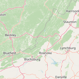
Use this park location map to pinpoint Hunting Camp Creek Wilderness in United States of America, understand its exact geographic position, and read its mapped placement within the surrounding landscape more clearly.

Pigeon | © OpenStreetMap contributors

Location context for Hunting Camp Creek Wilderness

Bland CountyVirginia
Recorded earthquake history

Examine Historical Earthquake Records for Hunting Camp Creek Wilderness

Explore the documented history of seismic events occurring near Hunting Camp Creek Wilderness. MoriAtlas provides a clear catalogue of recorded activity to assist in understanding the regional seismic context of these Virginia highlands through accessible event data.

Hunting Camp Creek Wilderness Earthquake History

Catalogued events

3 events

Strongest magnitude

Magnitude 4.7

Most recent event

Jun 26, 1995

This history includes earthquakes recorded inside the park or within 50 km of its borders

Park atlas

Compare surrounding regional geography and connected central Appalachian mountain terrain.

Parks Near Hunting Camp Creek Wilderness And Related Protected Landscapes

Browse protected areas and national forest reserves adjacent to Hunting Camp Creek Wilderness to compare regional ridge and valley terrain. Evaluating nearby wilderness corridors provides broader context on the conservation network spanning the central Appalachian mountain region.
A watercolor painting showing a soft, stylized landscape with rolling green hills, a winding stream, and trees under a pale sky.
Protected areaVirginia
0.2 km away#1 closest

Southwest

Garden Mountain Wilderness: Appalachian Protected Area and Regional Landscape Geography

Old-growth forest and ridge-bound Appalachian terrain in Virginia

Garden Mountain Wilderness encompasses a significant Appalachian ridge and the deep Lick Creek valley within western Virginia. This protected area harbors diverse hardwood forests, old-growth remnants, and critical habitat for rare species. The topography is defined by parallel ridges and enclosed valleys, showcasing the geological complexity of the central Appalachians and the importance of localized conservation efforts.

Area
13.48 km²
Established
2009
IUCN
Ib
Relief
Mountain
A soft, light-toned watercolor illustration of a winding creek flowing through a lush, green landscape with distant rolling hills and scattered trees.
Wildlife reserveBland County
11 km away#2 closest

Northeast

Kimberling Creek Wilderness: Geography and Protected Land Boundaries in Bland County

A trail-free Appalachian wilderness reserve in Jefferson National Forest

Kimberling Creek Wilderness represents a significant protected enclave in the central Appalachians of Virginia. This detail covers the steep topography extending from Kimberling Creek to the ridgeline of Hogback Mountain, characterized by sheltered cove forests and diverse oak-hickory stands. The area offers a rare glimpse into recovering eastern old-growth forest ecosystems within an entirely trail-free wilderness environment.

Area
23.99 km²
Established
1984
IUCN
Ib
Relief
Mountain
A horizontal watercolor painting of rolling green hills, a winding path, and clusters of deciduous and coniferous trees.
Wildlife reserveWythe County
30 km away#3 closest

South

Little Dry Run Wilderness: Protected Wildlife Reserve Map and Geography

A detailed geographic study of southern Blue Ridge terrain.

Little Dry Run Wilderness is a protected mountain basin in Wythe County, marked by its dense hemlock-lined stream corridors and forested ridges. This record outlines the park boundaries, watershed structure, and the complex topography that characterizes this integral component of the Mount Rogers National Recreation Area.

Area
11.57 km²
Established
1984
IUCN
Ib
Relief
Mountain
Wildlife reserveVirginia
35 km away#4 closest

Southwest

Raccoon Branch Wilderness: Mapping Protected Wildlife Reserves in Southwest Virginia

Rugged quartzite ridges and Appalachian stream corridors

The Raccoon Branch Wilderness represents a significant protected area within the Southern Blue Ridge mountains. Its geography is characterized by parallel ridgelines and deeply cut drainage channels that support rare plant communities and endangered aquatic life. This wilderness serves as a vital component of the regional Mount Rogers cluster, preserving a representative segment of Appalachian highland terrain.

Area
17.1 km²
Established
2009
IUCN
Ib
Relief
Mountain
Wildlife reserveGrayson County
43 km away#5 closest

South

Little Wilson Creek Wilderness: Protected Appalachian Forest and High Elevation Geography

Mapping the ridges, stream systems, and balds of Grayson County

Little Wilson Creek Wilderness is a significant protected area in southwestern Virginia, featuring elevations exceeding 4,800 feet. The region spans a diverse ecological landscape of rare high country bogs, northern hardwood forests, and old growth remnants that drain into the New River system. Gain insights into the terrain and boundaries of this prominent Blue Ridge Mountain wilderness.

Area
22.1 km²
Established
1984
IUCN
Ib
Relief
Mountain
Protected areaVirginia
44 km away#6 closest

Southwest

Lewis Fork Wilderness: Geography and Protected Land Profile in Southwestern Virginia

High-elevation Appalachian backcountry and ridgeline mapping

Spanning the ridgelines near the summit of Mount Rogers, Lewis Fork Wilderness serves as a key ecological anchor for Virginia. This protected backcountry offers a dense mosaic of forest types, ranging from oak-hickory stands to rare spruce-fir habitats. The landscape features steep terrain and pristine mountain streams, providing a concentrated look at the environmental complexity of the southern Appalachian Mountains.

Area
24.59 km²
Established
1984
IUCN
Ib
Relief
Mountain
A soft, horizontal watercolor painting depicting layers of rolling mountain ridges and evergreen forests in shades of green, yellow, and light pink.
Protected landscapeVirginia
About 52 km away#7 closest

Southwest

Mount Rogers National Recreation Area: Virginia Appalachian Highlands Protected Landscape

Mapping high-elevation ridgelines and wilderness corridors.

Located in southwestern Virginia, Mount Rogers National Recreation Area preserves a vast expanse of southern Appalachian mountain terrain. The landscape features spruce-fir forests, alpine-style balds, and deep valley watersheds. This protected area serves as a primary geographic anchor for hikers and conservationists, housing the highest peak in the state and extensive federally designated wilderness segments within its borders.

Area
626.52 km²
Established
1966
Relief
Mountain
Climate
Temperate
Wildlife reserveVirginia
65 km away#8 closest

Northeast

Mountain Lake Wilderness: Protected Appalachian Geography and Mountain Landscapes

High-elevation wetlands and ridge-line geography in Virginia

Mountain Lake Wilderness protects a compact yet biologically diverse landscape where cool, moist conditions support rare mountain bogs and red spruce forests. This protected area along the Eastern Continental Divide features rocky outcrops like White Rocks and War Spur Overlook, providing panoramic views of the surrounding Ridge and Valley terrain within the Jefferson National Forest.

Area
44.66 km²
Established
1984
IUCN
Ib
Relief
Mountain

Common questions about visiting, size, designation, and location context for Hunting Camp Creek Wilderness

Hunting Camp Creek Wilderness FAQs for park facts, access, geography, and protected area context

Find quick answers about Hunting Camp Creek Wilderness, including protected-area facts, park geography, trail and visitor context, and how the park fits into its surrounding country and regional landscape.
MoriAtlas Explorer

Continue Your Protected Areas Search Across the Global Atlas

Deepen your exploration by continuing the structured search for national parks and protected areas worldwide. Utilize the comprehensive filtering capabilities to compare different conservation landscapes and refine your understanding of global park geography. Discover more about the distribution and characteristics of protected natural areas.

Global natural geography