
Mori Atlas logo
Nature reserveIberg bei Markershausen

Examining the ecological landscape and limestone cliff structures of this protected area in northern Hesse

Iberg bei Markershausen Nature Reserve: Geological Formations and Calcareous Forest Habitats in Hesse

(Naturschutzgebiet Iberg bei Markershausen)

Iberg bei Markershausen serves as a significant protected nature reserve on the southwestern slope of the Ringgau plateau in Hesse, Germany. This 32-hectare site contains an orchid-rich beech forest and a 180-meter-long limestone cliff formation that defines its steep, layered topography. As part of a broader Natura 2000 network, the area protects essential calcareous grasslands and relict yew populations within the Werra-Meißner-Kreis region.

calcareous beech forestMuschelkalk hillslopeNatura 2000 siteNaturschutzgebietorchid-rich woodlandlimestone cliff
A colorful, flat-style vector illustration showing a tall, two-tiered waterfall flowing between steep, rocky cliffs surrounded by a forest of pine and deciduous trees and a winding river in the foreground.

Iberg bei Markershausen

Nature reserve

Park overview

Structured park overview, official facts, and landscape profile for Iberg bei Markershausen

Iberg bei Markershausen park facts, protected area profile, and essential visitor context

Review the core facts for Iberg bei Markershausen, including designation, size, terrain, visitor scale, habitats, and operating context in one park-focused overview.

About Iberg bei Markershausen

Iberg bei Markershausen is a compact but ecologically rich protected area in the Werra-Meißner-Kreis of northern Hesse, managed under German nature reserve law and integrated into the European Natura 2000 network. The reserve sits on the southwestern slope of the Iberg, a 434 meter Muschelkalk summit that forms the southernmost spur of the Ringgau plateau overlooking the Werra valley.

The landscape is shaped by the underlying limestone geology. Shallow calcareous soils, exposed rock faces, and a warm southwesterly aspect have produced a mosaic of habitat types unusually close together: orchid beech forest, montane maple-lime scree woodland, woodland barley beech woodland, and dry limestone grassland with juniper at the base of the slope. Geologically, the cliff line marks both a former rockfall event and a still-visible wall of Muschelkalk bedrock that gives the site added geoscientific interest.

Ecologically, the reserve's defining trait is the density and variety of its forest flora. The beech canopy shelters layers of spring-flowering geophytes that color the woodland floor before leaf-out, alongside a long list of orchids, gentians, and other calciphile species. The woodland margins and grassland support a recorded assemblage of day-flying butterflies and burnet moths. Yew, historically common on 'Iberg' sites and the reason for the hill's name, persists here as a protected sub-canopy species beneath the dominant beech.

Since 1988 the southwest slope has been a formally designated Naturschutzgebiet, and since 2008 it has been part of the larger 'Wälder und Kalkmagerrasen der Ringgau Südabdachung' Flora-Fauna-Habitat area. It belongs administratively to the Geo-Naturpark Frau-Holle-Land and is crossed by the certified Werra-Burgen-Steig Hessen long-distance trail between Altefeld and Markershausen.

Quick facts and research context for Iberg bei Markershausen

The Iberg bei Markershausen nature reserve lies in the municipality of Herleshausen, within the Werra-Meißner-Kreis of northern Hesse. It is positioned on the southern rim of the Ringgau plateau, where the Werra once separated the Muschelkalk massif from the Thuringian Basin.

The reserve protects roughly 32 hectares between about 310 and 434 meters elevation. It is classified as an IUCN Category IV Habitat/Species Management Area, was designated as a Naturschutzgebiet in 1988, and is integrated into a larger Natura 2000 site focused on calcareous woodland and dry grassland.

Protection and recognition

Official terrestrial conservation status, designation history, and recognition data

Iberg bei Markershausen Protection Status and Designated Area Records

Iberg bei Markershausen maintains a documented terrestrial protection status established in two thousand eight. Structured conservation records outline the official designation history and management scope for the protected area.

Protection details

Protection scope
Terrestrial
Designated year
2008
Transboundary protection
No
WDPA ID
163845
Park context

Deeper park guide and search-rich context for Iberg bei Markershausen

Iberg bei Markershausen history, landscape, wildlife, and travel context

Explore Iberg bei Markershausen through its history, landscape character, ecosystems, wildlife, conservation priorities, cultural context, and seasonal travel timing in a structured park guide built for atlas discovery and search intent.

Why Iberg bei Markershausen stands out

The reserve is best known for its orchid-rich beech forest on Muschelkalk, its dense display of spring geophytes on the forest floor, and the 180 meter limestone cliff that runs along the protected slope. It is also notable for the unusual persistence of European yew, Taxus baccata, growing as a second canopy layer beneath beech; the very name 'Iberg' is associated with historic yew stands, hinting at the tree's long cultural and ecological presence here.
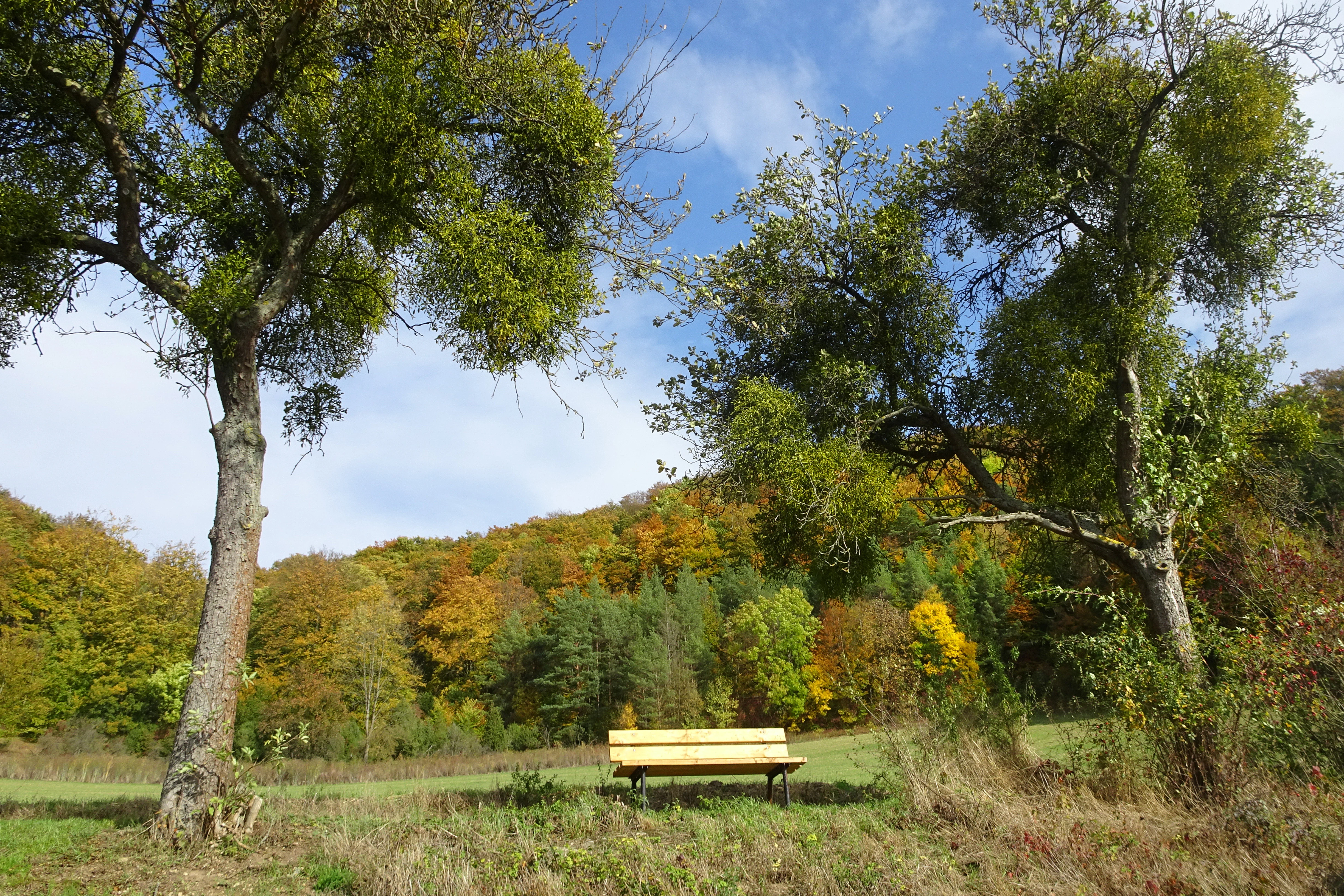
A solitary light wood bench sits in a grassy meadow, framed by two large trees with visible mistletoe in their branches, with a forested hillside in autumn colors in the background under a blue sky.
A wooden bench situated in a meadow at the edge of a mixed deciduous forest in autumn at Iberg near Markershausen.

Iberg bei Markershausen history and protected-area timeline

The Iberg bei Markershausen gained formal protection relatively recently in modern conservation terms. On 6 July 1988 the Regierungspräsidium in Kassel issued an ordinance designating the southwestern slope of the Iberg as a Naturschutzgebiet. The ordinance came into force on 15 August 1988 through publication in the Hessian state gazette.

The purpose of the designation was specifically to protect the mosaic of limestone rock faces, nutrient-poor calcareous grassland, calcareous beech forest, and geophyte-rich mixed deciduous woodland along with the threatened species living there. The reserve was assigned the national identifier 1636016 and the World Database on Protected Areas code 163845.

In 2008 the area was incorporated into the broader European network as part of the Flora-Fauna-Habitat site 'Wälder und Kalkmagerrasen der Ringgau Südabdachung' under Natura 2000 site number 4926-305, reinforcing the protection of its calcareous woodland and dry grassland habitats. The hill itself carries a longer cultural footprint: the name 'Iberg' reflects historical yew stands and is one of several similarly named hills in Germany whose identity is tied to Taxus baccata.

Iberg bei Markershausen landscape and geographic character

The Iberg rises to about 434 meters at the southern end of the Ringgau plateau in the Werra-Meißner-Kreis, where the Werra has carved the Muschelkalk rim of the Thuringian Basin into a series of isolated 'Zeugenberge', or outlier hills. The Iberg itself is one such witness hill, separated from the main plateau by tectonic faulting along the Netra-Ifta valley.

The protected area lies on the southwestern flank of the hill, between roughly 310 and 434 meters in elevation. The dominant feature is a 180 meter long limestone cliff reaching up to about 30 meters high, accompanied by scattered remnants of an older rockfall that line the slope as geological witnesses to past slope failure.

Below the cliff the terrain slopes down gently through forest, opening at the foot into a sun-exposed calcareous dry grassland where juniper forms much of the year-round green character of the open landscape. The combination of steep rock face, mixed deciduous woodland, and open grassland gives the protected area a layered, sharply defined topography despite its modest size.
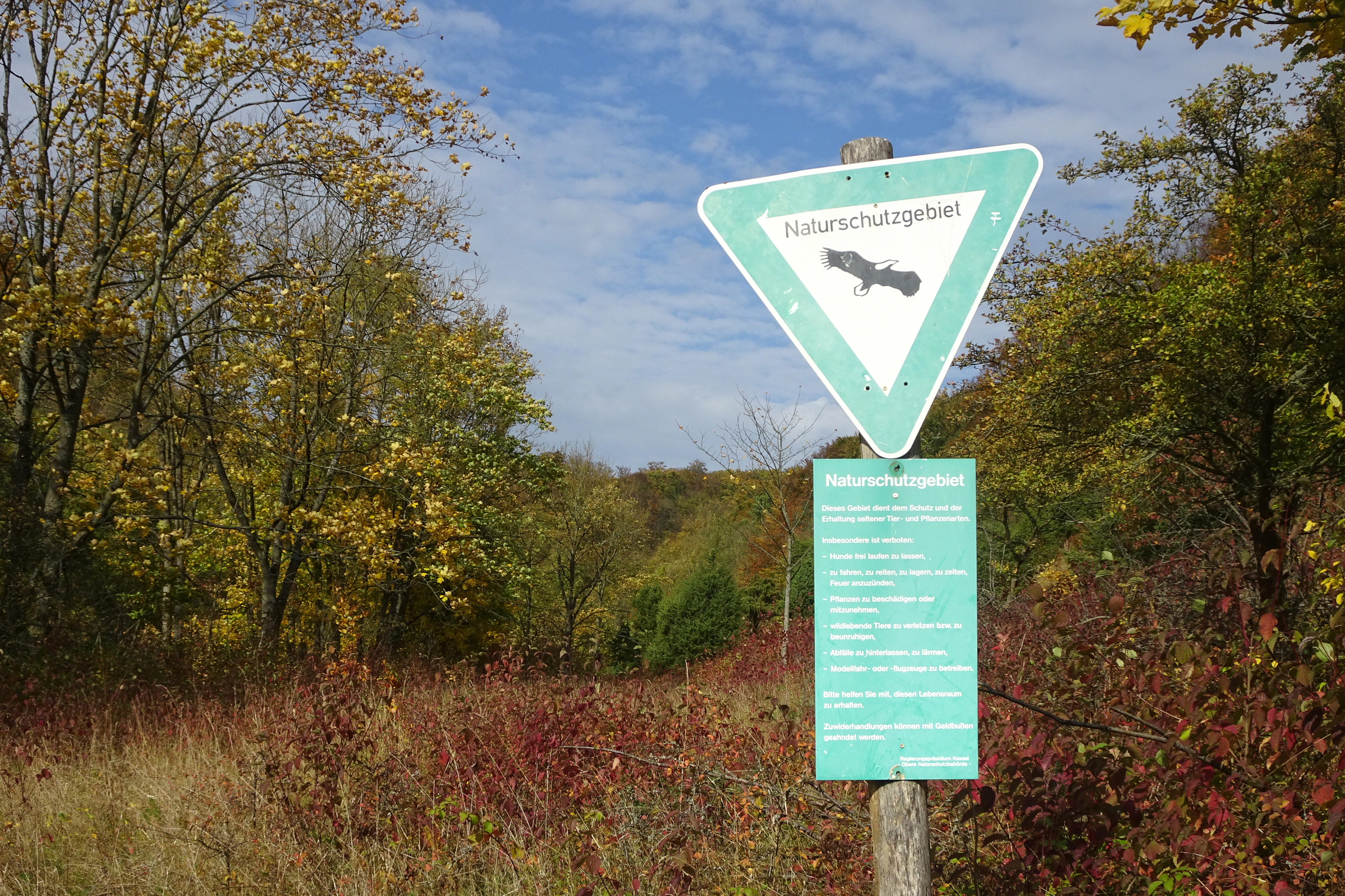
A German nature reserve sign, Naturschutzgebiet, mounted on a wooden post, set against an autumn forest and hilly landscape.
A nature reserve sign at Iberg bei Markershausen marking the protected area.

Iberg bei Markershausen ecosystems, habitats, and plant life

The nature of the Iberg bei Markershausen is defined by the interaction between Muschelkalk bedrock, shallow calcareous soils, and a warm southwesterly exposure. Forest dominates the reserve, with orchid-rich beech woodland as its core habitat type and woodland geranium beech forest, montane maple-lime scree woodland, and woodland barley beech forest as additional woodland communities.

The forest floor is unusually rich in spring geophytes, plants that flower before the beech canopy leafs out and color the woodland in early season. Among the recorded species are bastard and acute-leaved graslilies, rock and long-leaved hare's ear, white and red helleborines, mountain crown vetch, spotted orchid, brown-red helleborine, fringed gentian, musk orchid, Turk's cap lily, bird's nest orchid, fly orchid, pyramidal orchid, bitter milkwort, and wild pear, along with common and named variants of Daphne.

On the sunny lower slope the habitat shifts to dry calcareous grassland rich in orchids and fringed by juniper, while open woodland edges create transitional zones where 38 species of butterflies and burnet moths have been recorded. The European yew persists as a second tree layer beneath the beech canopy, a relict of the species' once-broader distribution and the reason the hill carries an 'Iberg' name.

Iberg bei Markershausen wildlife and species highlights

The wildlife significance of the Iberg bei Markershausen lies less in large mammal populations than in the assemblage of protected and habitat-specialist species that depend on the calcareous forest and dry grassland mosaic. Bat species such as Bechstein's bat and the greater mouse-eared bat use the old woodland structure, while the Eurasian lynx is listed among the protected species for which the surrounding Natura 2000 site has been designated.

In the open habitats, the yellow-bellied toad (Bombina variegata) is among the protected amphibians that the calcareous woodland and grassland complex supports. The treeline edges and dry grassland at the foot of the slope have yielded records of 38 day-flying butterfly and burnet moth species, an unusually high diversity for such a small protected area and an indicator of the quality of the open calcareous habitats.

Iberg bei Markershausen conservation status and protection priorities

Conservation significance at the Iberg centers on the protection of a small but exceptionally species-rich calcareous habitat complex. The 1988 designation as a Naturschutzgebiet by the Regierungspräsidium Kassel formally protected the southwest slope for its limestone rock faces, nutrient-poor calcareous grassland, calcareous beech forest, and geophyte-rich deciduous woodland, together with their threatened plant and animal species.

Since 2008 the reserve has also been part of the larger Flora-Fauna-Habitat site 'Wälder und Kalkmagerrasen der Ringgau Südabdachung' within the Natura 2000 network. At the European level, the woodland geranium beech forest forms the core of that habitat area, supplemented by small-leaved lime and orchid beech forests, slope and ravine mixed forests, and bedstraw oak-hornbeam forests, while the open ground is characterized by lowland hay meadows and orchid-rich dry calcareous grassland.

The protected status of European yew, a species once much more widespread in central European forests and now reduced through centuries of exploitation, is a particular focus here. The continued presence of yew beneath the beech is treated as a conservation priority, and the protection of the orchid flora further justifies the reserve's high ratio of protected species to area.

Iberg bei Markershausen cultural meaning and human context

The cultural fingerprint of the Iberg is unusually direct: the hill's name is itself a historical record. 'Iberg' derives from the European yew, Taxus baccata, and across Germany a number of hills share this name as markers of former yew stands. At the Iberg bei Markershausen the yew persists as a second tree layer beneath beech, making the hill both a linguistic and biological heritage site for the species.

The reserve also belongs to the Geo-Naturpark Frau-Holle-Land, a regional geopark that ties the protected natural area to broader cultural and landscape storytelling in northern Hesse. The area is crossed by the 'Werra-Burgen-Steig Hessen', a long-distance trail certified by the Deutscher Wanderverband as a 'Qualitätsweg Wanderbares Deutschland', connecting the site to the Werra valley's wider network of castles, villages, and historic footpaths.

Top sights and standout views in Iberg bei Markershausen

The defining highlights of the Iberg bei Markershausen cluster around three connected strengths. First, the geology: a 180 meter limestone cliff and the remains of an older rockfall that give the protected slope a sharp physical relief and significant geoscientific interest.

Second, the flora: an orchid-rich beech forest underlain by one of the densest displays of spring geophytes in the Werra-Meißner-Kreis, with dozens of orchids, gentians, and calciphile species recorded. Third, the persistence of European yew beneath the beech canopy, a living link to the historical meaning of the hill's name and a conservation priority in its own right.

These features are reinforced by formal protection as a Naturschutzgebiet and as part of a Natura 2000 Flora-Fauna-Habitat area, together with safe access along forest tracks and through the Werra-Burgen-Steig long-distance trail.

Best time to visit Iberg bei Markershausen

The character of a visit to the Iberg bei Markershausen shifts notably with the seasons because much of the reserve's ecological signal is seasonal. Early spring is the most botanically expressive period, when the spring geophytes beneath the beech canopy flower before leaf-out and the woodland floor briefly carries the greatest concentration of plant diversity.

Late spring and early summer bring the orchids and the flowering peak of the calcareous dry grassland at the slope's foot, while summer and early autumn offer the warmest conditions for viewing the open grassland and its butterflies. Autumn emphasizes the structural character of the beech forest and the cliff face, while winter opens up views along the unfenced forest and farm tracks that cross the reserve and the Werra-Burgen-Steig long-distance trail.


Monthly climate preview

Long-term representative measurements of monthly averages across the protected terrain

Iberg bei Markershausen Climate Normals, Annual Temperature and Precipitation Rhythm

Historical data records mean temperatures ranging from sub-zero winter lows to warm summer maximums alongside consistent daily precipitation rates throughout the year. Reviewing the complete twelve-month sequence provides deep insight into long-term meteorological patterns at this specific coordinate.
Annual mean8 °C
-1 °C18 °C
Jan-1°
Feb
Mar
Apr
May12°
Jun16°
Jul18°
Aug18°
Sep14°
Oct
Nov
Dec
Warmest month
July

18.3 °C

Coolest month
January

-1.1 °C

Wettest month
July

2.6 mm/day

Driest month
April

1.4 mm/day

Park location guide

Geography guide, regional context, and park location map for Iberg bei Markershausen

Iberg bei Markershausen park geography, regions, and map view in Germany

Understand where Iberg bei Markershausen sits in Germany through a broader geographic reading of the surrounding landscape, nearby location context, and its mapped position within the national park landscape.

How Iberg bei Markershausen fits into Germany

Germany is a federal republic in Western and Central Europe with a population of over 83 million across sixteen constituent states. It is Europe's largest economy by nominal GDP and a major global exporter and importer. The capital is Berlin, and the country borders Denmark, Poland, Czech Republic, Austria, Switzerland, France, Luxembourg, Belgium, and the Netherlands.

Wider geography shaping Iberg bei Markershausen in Germany

Germany is located in Western and Central Europe, spanning 357,022 km². It borders Denmark to the north, Poland and the Czech Republic to the east, Austria and Switzerland to the south, and France, Luxembourg, Belgium, and the Netherlands to the west. The country has coastlines on the Baltic Sea and North Sea to the north, with the Alps located in the southern region.

Map view of Iberg bei Markershausen

Use this park location map to pinpoint Iberg bei Markershausen in Germany, understand its exact geographic position, and read its mapped placement within the surrounding landscape more clearly.

Pigeon | © OpenStreetMap contributors

Location context for Iberg bei Markershausen

Hesse

Visualizing calcareous beech forests, limestone cliffs, and protected habitats

Iberg bei Markershausen Photos and Landscape Scenery Exploration

Visual documentation reveals the distinct topography and limestone terrain defining Iberg bei Markershausen. Photographic evidence illustrates the orchid-rich woodlands, steep rock formations, and protected habitats of the northern Hesse reserve.

A solitary light wood bench sits in a grassy meadow, framed by two large trees with visible mistletoe in their branches, with a forested hillside in autumn colors in the background under a blue sky.

A view of a hillside in autumn with a mix of green and orange foliage; patches of scrubby shrubs in the foreground, and a dense deciduous forest covering the higher slopes.

A German nature reserve sign, Naturschutzgebiet, mounted on a wooden post, set against an autumn forest and hilly landscape.

Park atlas

Compare adjacent Muschelkalk hills and connected calcareous forest landscapes in northern Hesse

Explore Parks Near Iberg bei Markershausen and Protected Areas in the Surrounding Region

Browse other parks near Iberg bei Markershausen to examine similar limestone cliffs, orchid-rich beech woodlands, and protected habitats across the surrounding Ringgau terrain. Expanding the geographic scope reveals how regional conservation areas share comparable geological features and ecological networks.
Nature reserveThuringia
About 3.4 km away#1 closest

Northeast

Werra bis Treffurt mit Zuflüssen: Protected River and Floodplain Network in Thuringia

Mapping an extensive 191 kilometer Natura 2000 river corridor.

The Werra bis Treffurt mit Zuflüssen protected area serves as a vital ecological corridor in Thuringia. This site encompasses a complex mosaic of fast-flowing highland brooks, expansive floodplain meadows, inland salt sites, and rare dissolution lakes. Its geography bridges high-altitude source regions with lower river valleys, creating a distinctive landscape transect that supports essential freshwater habitats and rare aquatic species across the state.

Area
22.6 km²
Established
2008
IUCN
IV
Relief
Mixed relief
A watercolor painting depicting a soft, green meadow landscape with gentle rolling hills in the background and scattered trees.
Nature reserveGermany
About 4.3 km away#2 closest

North

Feuchtwiesen bei Lüderbach Nature Reserve: Regional Geography and Protected Landscape Atlas

A diverse wetland and grassland reserve in northern Hesse, Germany

Spanning 40 hectares in the Werra-Meißner-Kreis district, Feuchtwiesen bei Lüderbach protects a complex mosaic of reedbeds, eutrophic ponds, and floodplain forests. This nature reserve serves as an important ecological link in the Netra-Ifta valley, bridging valley-bottom wetlands with the limestone-rich slopes of the Weinberg hill to create a distinct and valuable natural terrain in the German landscape.

Area
0.41 km²
Established
1995
Relief
Upland
Climate
Temperate
Nature reserveThuringia
About 5.5 km away#3 closest

Northeast

Werra-Aue zwischen Breitungen und Creuzburg: Protected Floodplain and River Geography

Nature reserve sanctuary in western Thuringia

Spanning over 33 kilometers of the Werra river, this protected floodplain is defined by its distinctive geological sinkholes, seasonal wetlands, and diverse bird habitats. Discover the layered conservation status and riparian terrain that mark this significant Thuringian nature reserve as a crucial node for European ecological connectivity.

Area
25.78 km²
Established
2007
IUCN
IV
Relief
Lowland
Watercolor painting of a green landscape featuring rolling hills and sparse trees.
Nature reserveWerra-Meißner-Kreis
About 6.8 km away#4 closest

North

Dreiherrenstein-Eschenberg-Kreutzerberg Nature Reserve and Border Landscape Geography

Protected calcareous forests and limestone ridges in Werra-Meißner-Kreis

Spanning 206 hectares of the Ringgau escarpment, this reserve features ancient beech forests, steep limestone cliffs, and rare steppe-heath grasslands. It sits at a cultural and ecological intersection, preserving Cold War-era boundary markers alongside post-glacial biological relicts within the broader Hessian protected-area network.

Area
2.063 km²
Established
1998
IUCN
IV
Relief
Mountain
Watercolor painting of a rolling green landscape with a winding trail leading toward purple mountains under a soft light.
Nature reserveWartburgkreis
About 6.8 km away#5 closest

Southwest

Mertelstal - Heldrastein: Protected Nature Reserve and Forested Limestone Geography in Wartburgkreis

Mapping the natural relief and ecological boundaries of a central German nature reserve.

Mertelstal - Heldrastein stands as a protected natural landmark in the Wartburgkreis district, defined by its dramatic limestone cliffs and ancient beech forest canopy. The reserve features a unique vertical relief above the Werra river valley, housing rare orchid communities and specialized bryophytes. This entry maps the structural geography and conservation value of the site, highlighting its dual identity as both a Natura 2000 protected habitat and a place of deep historical resonance across the former inner-German border landscape.

Area
2.525 km²
Established
1997
IUCN
IV
Relief
Mountain
A horizontal watercolor illustration of a gentle, rolling landscape with green trees, meadow grass, and distant hills under a light blue sky.
Nature reserveWartburgkreis
About 7.2 km away#6 closest

South

Alte Werra Nature Reserve: Floodplain Geography and Protected Meadow Landscapes in Wartburgkreis

Essential river valley habitats and Natura 2000 protected areas.

Alte Werra serves as a critical protected landscape in the Wartburgkreis district of Germany. Centered on the Middle Werra valley, this 258 hectare nature reserve protects unique floodplain terrain including oxbow remnants, the Böllerteiche ponds, and diverse wet grassland habitats. The site remains a key reference point for studying riverine geomorphology and protected bird corridors in the Thuringia region.

Area
2.578 km²
Established
1996
IUCN
IV
Relief
Lowland
Nature reserveThuringia
About 7.5 km away#7 closest

East

Wilhelmsglücksbrunn Nature Reserve and Werra Valley Protected Landscape Geography

A mapped overview of inland saline springs in Thuringia

The Wilhelmsglücksbrunn nature reserve preserves a rare inland saline ecosystem within the flat Werra floodplain of western Thuringia. This site sustains a complex landscape of reed beds, wet meadows, and brine-fed habitats that connect to the broader Green Band ecological corridor, providing essential staging grounds for diverse migratory bird populations.

Area
0.773 km²
Established
2000
IUCN
IV
Relief
Lowland
Watercolor illustration showing a wide landscape with green trees, rolling hills, and distant mountains under a pale sky.
Nature reserveHessen
About 7.7 km away#8 closest

North

Graburg Nature Reserve and Protected Shell-Limestone Massif in Northern Hessen

Mapped protected areas and botanical landscape geography

Graburg is a compact shell-limestone plateau located in the Ringgau range of northern Hessen. This nature reserve is characterized by its high conservation value, featuring ancient calcareous beech forests, dramatic rock faces, and extensive historic landslide zones that support one of the most botanically diverse habitats in central Germany.

Area
3.41 km²
Established
1965
IUCN
IV

Common questions about visiting, size, designation, and location context for Iberg bei Markershausen

Iberg bei Markershausen FAQs for park facts, access, geography, and protected area context

Find quick answers about Iberg bei Markershausen, including protected-area facts, park geography, trail and visitor context, and how the park fits into its surrounding country and regional landscape.
MoriAtlas Explorer

Continue Your Protected Areas Search Across the Global Atlas

Deepen your exploration by continuing the structured search for national parks and protected areas worldwide. Utilize the comprehensive filtering capabilities to compare different conservation landscapes and refine your understanding of global park geography. Discover more about the distribution and characteristics of protected natural areas.

Global natural geography