Mori Atlas logo
State or regional parkIllawarra Escarpment State Conservation Area

Tracing the mapped boundaries and vertical terrain of this expansive New South Wales protected landscape.

Illawarra Escarpment State Conservation Area: A Geographic Atlas of Sandstone Cliffs and Forested Ridges

The Illawarra Escarpment State Conservation Area forms a dramatic, multi-sectioned boundary between the narrow coastal plain and the Southern Tablelands of New South Wales. This atlas entry details the geography of six distinct reserve segments stretching from Stanwell Park to Horsley, documenting the 40-kilometre chain of sandstone cliffs, rainforest-filled gullies, and rugged ridgelines. Gain insight into the vertical relief and mapped natural features that define this significant Australian protected landscape.

coastal escarpmentsandstone cliffssubtropical rainforestsclerophyll forestbushwalkinglookouts

Illawarra Escarpment State Conservation Area

State or regional park

Park overview

Structured park overview, official facts, and landscape profile for Illawarra Escarpment State Conservation Area

Illawarra Escarpment State Conservation Area park facts, protected area profile, and essential visitor context

Review the core facts for Illawarra Escarpment State Conservation Area, including designation, size, terrain, visitor scale, habitats, and operating context in one park-focused overview.

About Illawarra Escarpment State Conservation Area

The Illawarra Escarpment State Conservation Area preserves a representative stretch of one of eastern Australia's most visually distinctive landforms. The escarpment itself is the abrupt western edge of the Illawarra coastal plain, where older sandstone uplands give way to a narrow lowland ribbon fringed by the Tasman Sea. Within the conservation area, that transition is expressed as a sequence of steep cliffs, forested slopes, sheltered gullies, and elevated plateaus that together create a landscape of strong contrasts over a relatively short horizontal distance.

Although the protected area is modest in extent, its fragmented structure reflects both the way the escarpment has been settled and visited, and the practical history of land reservation in New South Wales. By spacing its six sections between Stanwell Park in the north and Horsley in the south, the conservation area effectively threads through the Illawarra region, covering roughly 40 kilometres of cliffline. This makes it function less like an isolated wilderness reserve and more like a backbone of protected landscape running along the western edge of the Illawarra urban corridor.

The conservation area is managed by the NSW National Parks and Wildlife Service, which is also responsible for the broader suite of Illawarra and escarpment reserves. Visitors encounter a landscape that lends itself naturally to outdoor activity: walking tracks descend to waterfalls and pools, cliff-edge lookouts gaze out toward the coast, and quieter ridgelines support forest experiences away from populated areas. Its character as a working recreational landscape is balanced against its role as a refuge for native plants, animals, and geological features that would otherwise be encroached upon by the surrounding urban and rural development.

Quick facts and research context for Illawarra Escarpment State Conservation Area

The Illawarra Escarpment State Conservation Area is managed by the NSW National Parks and Wildlife Service and covers approximately 2,772 hectares across six non-contiguous sections between Stanwell Park and Horsley, inland of the Illawarra coast. It was formally reserved in 1980 and protects a stretch of one of Australia's most prominent coastal escarpments, with geological substrates around 30 million years old. The area sits directly west of Wollongong, the nearest major city, and is closely linked with the everyday recreation and landscape identity of the Illawarra region.

Protection and recognition

Documented terrestrial protection scope, designation history, and governance records

Illawarra Escarpment State Conservation Area Protection Status and International Recognition

Illawarra Escarpment State Conservation Area maintains a documented terrestrial protection scope without external international recognition listings on file. Structured records outline the official conservation status and management framework governing this protected landscape.

Protection details

Protection scope
Terrestrial
Transboundary protection
No
Park context

Deeper park guide and search-rich context for Illawarra Escarpment State Conservation Area

Illawarra Escarpment State Conservation Area history, landscape, wildlife, and travel context

Explore Illawarra Escarpment State Conservation Area through its history, landscape character, ecosystems, wildlife, conservation priorities, cultural context, and seasonal travel timing in a structured park guide built for atlas discovery and search intent.

Why Illawarra Escarpment State Conservation Area stands out

The Illawarra Escarpment State Conservation Area is best known for the striking cliffline that rises above the Illawarra coastal plain and for the way its forested slopes and lookouts frame the towns and beaches below. The area's combination of ancient sandstone geology, elevated rainforest patches, and panoramic coastal views gives it an identity that is unusually accessible for a protected landscape of its size. Equally important is its role as a recreational artery for the Illawarra region. Because it is composed of six separate sections along about 40 kilometres of escarpment, the conservation area functions almost like a chain of linked natural attractions, where each section has its own character of cliffs, gorges, lookouts, or forest, while together they preserve the broader escarpment ecosystem.
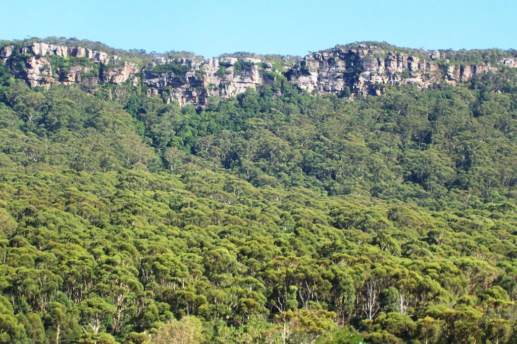
A wide view of the Illawarra Escarpment showing vertical sandstone cliff faces at the top of a heavily forested hillside.
The sandstone cliffs of the Illawarra Escarpment rising above dense eucalypt forest.

Illawarra Escarpment State Conservation Area history and protected-area timeline

The Illawarra Escarpment itself is a deeply ancient landscape, with geological foundations that the source materials describe as around 30 million years old. Long before its formal reservation, this country was inhabited and used by the Wodi Wodi people, whose connection to the land sustained for an estimated 20,000 years. Some of the summits and other features within the escarpment complex continue to hold spiritual and cultural significance for Aboriginal communities, and this deep Indigenous heritage is part of the area's identity as a protected place.

European exploration and use of the escarpment began in the colonial period. Surveyor-General Thomas Mitchell, working with convict labour, constructed a number of colonial roads across and along parts of the escarpment in 1834. These roads opened routes between the coastal settlements and the inland tablelands and left a lasting imprint on the landscape that is still visible in old alignments, cuttings, and tracks within the conservation area today.

Formal protection came in 1980, when the Illawarra Escarpment State Conservation Area was established as a dedicated reserve under the management of the NSW National Parks and Wildlife Service. Its creation reflected growing recognition of the need to conserve the escarpment's forest, geological values, and recreational landscapes in the face of expanding urban and industrial development in the Illawarra region.

Illawarra Escarpment State Conservation Area landscape and geographic character

The defining feature of the Illawarra Escarpment State Conservation Area is its dramatic vertical relief. The escarpment rises sharply from the narrow Illawarra coastal plain, producing long cliff faces, plunging slopes, and elevated sandstone benches that create a clear two-tier geography. From the base, walking tracks rise through forested foothills to reach dramatic cliff edges and rocky outcrops, while horizontal movement along the conservation area traces a near-continuous skyline above the coastal towns.

The terrain is varied within this compact setting. Steep sandstone cliffs dominate the upper edge of many sections, while below them lie sheltered gullies, fern gullies, and rainforest remnants that benefit from protected, moisture-trapping conditions. Rocky platforms, overhangs, and boulders support rock climbing and picnic sites, while more open ridgelines and slopes give way to views toward the Tasman Sea and the Illawarra suburbs below.

Water is a recurring theme in the landscape, with creeks descending the escarpment in short, steep courses that occasionally produce waterfalls and pools after rainfall. Across the six separate sections, these elements repeat with local variation, so the impression of the escarpment is consistent and recognisable while each section has its own combination of cliffs, forest, and lookouts.

Illawarra Escarpment State Conservation Area ecosystems, habitats, and plant life

The vegetation of the Illawarra Escarpment is strongly shaped by elevation, aspect, and exposure. Upper cliff edges and exposed ridgelines support drier sclerophyll forest communities adapted to wind, sun, and shallow soils. Sheltered gullies and south-facing slopes, by contrast, retain pockets of subtropical and temperate rainforest, where moisture and protection from fire allow richer, layered plant communities to persist.

Between these extremes lies a transition zone of mixed eucalypt forest with an understorey of tree ferns, palms, and shrubs. This mixture is one of the conservation area's most characteristic features: a relatively short walk can move a visitor from open, sun-drenched forest on a ridge top into a cool, fern-filled gully within a few hundred metres of horizontal distance.

The forest cover of the escarpment also plays an important ecological role for the broader Illawarra region, functioning as a wildlife corridor along the cliffline and linking larger patches of bush on the plateau above with smaller remnants and the coast below. Its fragmented but connected character distinguishes it from more isolated reserves in the surrounding landscape.

Illawarra Escarpment State Conservation Area wildlife and species highlights

The escarpment's mix of dry forest, moist gully vegetation, and cliffline habitats supports a varied fauna typical of the Illawarra region. Birds are a particular focus of visitors, with the mixture of open forest edges and denser rainforest pockets providing habitat for honeyeaters, parrots,robins, and raptors that hunt along the cliff edges.

Larger mammals, reptiles, and amphibians inhabit the more sheltered parts of the escarpment, where forest cover and rock shelter provide refuge. Possums and other arboreal marsupials make use of the taller trees in the gullies, while rock outcrops and fallen timber offer habitat for lizards and ground-dwelling species. The conservation area's role as a string of forested sections along the escarpment also gives it value for species that move through the landscape rather than being confined to a single site.

Illawarra Escarpment State Conservation Area conservation status and protection priorities

The Illawarra Escarpment State Conservation Area was assembled in 1980 primarily to safeguard a representative section of the Illawarra escarpment in the face of expanding urban and industrial growth in the region. Its protected status provides a buffer of forested land against the coastal plain, helping to retain vegetation, soils, and habitat connectivity that would otherwise be lost to development.

Conservation value here is closely tied to the area's geological and ecologicalcharacter. The ancient sandstone of the escarpment shapes the soils, water flow, and vegetation communities that support the area's native flora and fauna. By holding these processes and habitats in protected ownership, the reserve contributes to maintaining ecological function across the broader Illawarra landscape, even though its individual sections are relatively small.

Management responsibility lies with the NSW National Parks and Wildlife Service, which balances conservation outcomes with the area's strong recreational use. The conservation significance of the site is therefore expressed not only in what is preserved, but in how a working landscape oflookouts, walking tracks, picnic areas, and camping grounds is maintained alongside its natural values.

Illawarra Escarpment State Conservation Area cultural meaning and human context

The Illawarra Escarpment carries a deep and ongoing Aboriginal cultural history. The Wodi Wodi people lived in and moved through this country for an estimated 20,000 years, well before the arrival of European settlers. Some of the escarpment's summits and landscape features are of continuing spiritual significance to Aboriginal communities, and the area therefore holds values that extend well beyond its ecological or recreational profile.

The European history of the escarpment is also strongly inscribed on the landscape. Roads built by Surveyor-General Thomas Mitchell and convict labour in 1834 opened important routes between the Illawarra coast and the inland areas to the west. Remnants of these historic alignments and cuttings remain visible within the conservation area, layering additional human history onto thegeological and Aboriginal heritage of the place.

Top sights and standout views in Illawarra Escarpment State Conservation Area

The Illawarra Escarpment State Conservation Area stands out for the way it concentrates so many strongly contrasting experiences into a narrow band of landscape. Steep sandstone cliffs, cool rainforest gullies, exposed ridgelines, and coastal lookouts all fall within a reserve that hugs one of Australia's most recognisable escarpments. Its six sections between Stanwell Park and Horsley give it a connected, regional character that is unusual for a state conservation area.

Whatmost distinguishes the reserve is the combination of geology, accessibility, and setting. Its 30-million-year-old sandstone foundations, deep Aboriginal and colonial history, and direct backdrop to the Illawarra coastline and suburbs make it both a local everyday escape and a landscape of broader regional significance.

Best time to visit Illawarra Escarpment State Conservation Area

The character of a visit to the Illawarra Escarpment shifts with the seasons in ways that are typical of coastal escarpment environments in southern New South Wales. Cooler months tend to bring clearer skies, sharper views to the coast, and more comfortable conditions for longer walks and overnight camping, while the bush generally feels fresher after rain.

Warmer months highlight different qualities: waterfalls and creeks tend to be more impressive, native flowers and bird activity increase, and shaded gullies become especially appealing for walking. Across the year, sunrise and sunset on the cliff edges remain one of the strongest draws, with light and weather across the Tasman Sea producing constantly changing views from the lookouts.

Monthly climate preview

Long term representative temperature ranges and monthly precipitation patterns

Illawarra Escarpment State Conservation Area Climate and Weather by Month

Illawarra Escarpment State Conservation Area records measured monthly variations in long term average temperature and daily precipitation from representative coordinate data. Reviewing the complete twelve month climatology profile provides structured insight into annual environmental rhythms.
Annual mean15 °C
9 °C21 °C
Jan21°
Feb21°
Mar19°
Apr16°
May13°
Jun10°
Jul
Aug10°
Sep13°
Oct15°
Nov18°
Dec20°
Warmest month
January

21.4 °C

Coolest month
July

9.2 °C

Wettest month
February

4.5 mm/day

Driest month
July

1.8 mm/day

Park location guide

Geography guide, regional context, and park location map for Illawarra Escarpment State Conservation Area

Illawarra Escarpment State Conservation Area park geography, regions, and map view in Australia

Understand where Illawarra Escarpment State Conservation Area sits in Australia through a broader geographic reading of the surrounding landscape, nearby location context, and its mapped position within the national park landscape.

How Illawarra Escarpment State Conservation Area fits into Australia

Australia is a constitutional monarchy and federal parliamentary democracy comprising six states and ten territories. With a population of nearly 28 million, it is one of the world's most urbanised countries, with most people concentrated on the eastern seaboard. The country has a high Human Development Index and is known for its cultural diversity, ancient Aboriginal heritage, and unique wildlife.

Wider geography shaping Illawarra Escarpment State Conservation Area in Australia

Australia occupies the entire Australian continent, the island of Tasmania, and numerous smaller islands. It is the world's flattest and driest inhabited continent, featuring vast deserts in the interior (the Outback), tropical rainforests along the eastern coast, and a coastline bordering the Indian and Pacific Oceans.

Map view of Illawarra Escarpment State Conservation Area

Use this park location map to pinpoint Illawarra Escarpment State Conservation Area in Australia, understand its exact geographic position, and read its mapped placement within the surrounding landscape more clearly.

Pigeon | © OpenStreetMap contributors

Location context for Illawarra Escarpment State Conservation Area

New South Wales
Natural feature types

Explore the Natural Features of Illawarra Escarpment State Conservation Area

Continue your geographic discovery by examining the specific landforms and water systems within the Illawarra Escarpment State Conservation Area. MoriAtlas provides a structured look at the cliffs, forests, and gullies that shape this protected corridor, offering a clear view of the complex terrain found along the New South Wales coastline.
Recorded earthquake history

View Recorded Earthquake History for Illawarra Escarpment State Conservation Area

Examine the historical catalogue of seismic events recorded near the Illawarra Escarpment State Conservation Area. This resource from MoriAtlas allows users to trace regional seismic patterns through event dates, magnitudes, and precise epicentre distances, facilitating a clearer understanding of local landscape data.

Illawarra Escarpment Earthquake History

Catalogued events

7 events

Strongest magnitude

Magnitude 4.6

Most recent event

May 28, 2025

This history includes earthquakes recorded inside the park or within 50 km of its borders

Visual reference of sandstone cliffs, rainforest gullies, and coastal lookouts across protected terrain.

Illawarra Escarpment State Conservation Area Landscape Photos and Scenery

Visual documentation captures the dramatic vertical relief, ancient sandstone geology, and varied habitats across the six protected sections of Illawarra Escarpment State Conservation Area. Photographic observation reveals the complex terrain, forest canopies, and coastal vistas that define this regional conservation landscape.

A wide view of the Illawarra Escarpment showing vertical sandstone cliff faces at the top of a heavily forested hillside.

Park atlas

Compare surrounding regional geography and connected escarpment terrain across New South Wales.

Parks Near Illawarra Escarpment State Conservation Area And Related Protected Landscapes

Browse protected areas near Illawarra Escarpment State Conservation Area to compare similar coastal escarpments and forested sandstone terrain. Expanding the geographic view helps trace regional conservation networks and find adjacent natural reserves.
National parkNew South Wales
Park boundaries overlap#1 closest

Northwest

Dharawal National Park: Sandstone Landscapes and Upland Swamp Ecosystem Atlas

Discover mapped protected area boundaries and unique biodiversity.

Dharawal National Park, situated in New South Wales, is a significant protected area distinguished by its globally important upland swamp ecosystems, which exhibit the highest species richness of shrub and sedge communities found anywhere on Earth. This national park features a varied terrain, from steep gorges and waterfalls to sandstone woodlands and rainforest valleys, all contributing to its exceptional biodiversity and status as a crucial koala habitat within southern Sydney. Its landscape context on the Woronora Plateau provides a unique geographic perspective for understanding protected Australian natural areas.

Area
65.08 km²
Established
2012
IUCN
II
Relief
Mixed relief
National parkNew South Wales
0 km away#2 closest

Northeast

Royal National Park National Park: Geographic Atlas and Protected Landscape Context

Explore mapped park boundaries and regional terrain.

Royal National Park is a designated national park in New South Wales, Australia, offering rich opportunities for geographic discovery and landscape context analysis. This page serves as a foundational entry for understanding the park's protected status, its distinct natural terrain, and its mapped presence within the regional geography. Explore how this protected landscape contributes to Australia's broader atlas of natural areas.

Area
150.91 km²
Established
1879
IUCN
II
Relief
Mixed relief
A watercolor painting showing a soft, pastoral landscape with green trees, grassy plains, and rolling hills in the background on a white background.
State or regional parkNew South Wales
0 km away#3 closest

Northeast

Garawarra State Conservation Area: Protected Geography and Natural Landscapes in New South Wales

Ecological reserve features, mapped sandstone terrain, and temperate rainforest mosaics.

Garawarra State Conservation Area occupies a strategic position on the southern edge of the Sydney Basin, functioning as an important ecological buffer within a highly urbanised region. The park landscape is defined by its dramatic transition from dry sandstone heath and tall wet sclerophyll forests to humid, sheltered creek lines dominated by diverse rainforest flora. This protected area stands as a testament to the resilience of Sydney Sandstone ecosystems, offering a rich study in biodiversity within reach of the metropolitan sprawl.

Area
9.49 km²
Established
1987
Relief
Upland
Climate
Temperate
National parkNew South Wales
3.6 km away#4 closest

North

Heathcote National Park: Discover the Hawkesbury Sandstone Terrain and Mapped Protected Boundaries

Explore the rugged gorges and regional geography of this New South Wales national park.

Heathcote National Park preserves a significant example of the Sydney region's characteristic Hawkesbury sandstone landscape, presenting a terrain of deeply incised creek gorges and rocky valleys. Located in New South Wales, this protected national park offers valuable insights into regional geography and the mapped distribution of natural landscapes. Its rugged terrain and diverse ecosystems make it a key destination for understanding the protected area context of Australia's eastern seaboard.

Area
26.79 km²
Established
1943
IUCN
II
Relief
Mixed relief
National parkNew South Wales
6.5 km away#5 closest

Southwest

Macquarie Pass National Park: National Park Protected Landscape and Regional Geography

Mapped protected area boundaries and natural terrain context.

Macquarie Pass National Park is an important protected natural landscape situated in New South Wales. This page offers an atlas-focused view, detailing the park's precise geographic extent and its significance as a national park. Understanding its mapped boundaries and its position within the regional geography allows for a deeper appreciation of its protected status and the natural terrain it encompasses, serving as a key entry point for geographic discovery.

Area
11 km²
Established
1969
IUCN
II
Relief
Mountain
A soft, horizontal watercolor painting showing a coastal scene with grassy shores, calm water, and several small islands in the distance under a pale sky.
Nature reserveNew South Wales
About 10 km away#6 closest

South

Five Islands Nature Reserve; Protected Island Geography and Coastal Terrain Analysis

Mapping island remnants off the New South Wales coastline

This protected area consists of five distinct continental islands shaped by volcanic activity and ancient sea level changes. Today, the reserve acts as a critical refuge for seabirds and reptiles, maintaining a unique ecological footprint against the backdrop of the Illawarra coast. The site provides a rich case study in how small island geography functions as a remnant of a broader mainland landscape now separated by the Tasman Sea.

Area
0.26 km²
Established
1960
IUCN
IV
Relief
Lowland
National parkNew South Wales
12 km away#7 closest

Southwest

Budderoo National Park: Protected Landscape Exploration in New South Wales

Mapping the protected area and its regional geographic context.

Gain a clear understanding of Budderoo National Park as a protected national park situated within New South Wales. This detail page focuses on its mapped geographic features and protected landscape characteristics, providing critical context for atlas-based discovery. Explore the park's position within the broader regional geography of Australia and appreciate its identity as a conservation landscape.

Area
72.19 km²
Established
1986
IUCN
II
Climate
Subtropical
Nature reserveNew South Wales
About 16 km away#8 closest

Southwest

Robertson Nature Reserve: Mapping a Rare Rainforest Remnant in the New South Wales Highlands

Protected warm temperate rainforest and escarpment geography

Robertson Nature Reserve serves as a vital conservation anchor in the New South Wales Southern Highlands. This reserve protects a dense fragment of warm temperate rainforest, characterized by its low canopy and rich basaltic soil composition. The area offers an opportunity to study the distinct ecology of the historic Yarrawa Brush and its adaptation to the high rainfall conditions along the Illawarra Escarpment.

Area
0.053 km²
Established
1979
Relief
Upland
Climate
Temperate

Common questions about visiting, size, designation, and location context for Illawarra Escarpment State Conservation Area

Illawarra Escarpment State Conservation Area FAQs for park facts, access, geography, and protected area context

Find quick answers about Illawarra Escarpment State Conservation Area, including protected-area facts, park geography, trail and visitor context, and how the park fits into its surrounding country and regional landscape.
MoriAtlas Explorer

Continue Your Protected Areas Search Across the Global Atlas

Deepen your exploration by continuing the structured search for national parks and protected areas worldwide. Utilize the comprehensive filtering capabilities to compare different conservation landscapes and refine your understanding of global park geography. Discover more about the distribution and characteristics of protected natural areas.

Global natural geography