

Mori Atlas logo
Nature reserveIlse

Tracing the five protected sections along the Ilse stream corridor within the Lippe highlands.

Ilse Nature Reserve: A Mapped Exploration of Protected Riparian Landscapes in North Rhine-Westphalia

(Naturschutzgebiet „Ilse)

Ilse Nature Reserve protects a near-natural lowland stream and its surrounding floodplain across fourteen hectares in the Lippe district. This multi-sectioned corridor preserves a mosaic of wet meadows, riparian alder woodlands, and traditional orchard orchards that provide vital habitats for dragonflies, amphibians, and rare farmland birds. The reserve forms a critical link in the regional conservation geography, maintaining the ecological coherence of the Bega stream catchment within the rolling Lipper Bergland landscape.

riparian woodlandlowland streamfloodplain meadowsorchard meadowswetland habitatshedgerows

Ilse

Nature reserve

Park overview

Structured park overview, official facts, and landscape profile for Ilse Nature Reserve

Ilse Nature Reserve park facts, protected area profile, and essential visitor context

Review the core facts for Ilse Nature Reserve, including designation, size, terrain, visitor scale, habitats, and operating context in one park-focused overview.

About Ilse Nature Reserve

Ilse Nature Reserve is a compact, stream-focused protected area in the Lippe district of North Rhine-Westphalia. It was established in 2009 and is administered under the German Naturschutzgebiet designation, with the official code LIP-094. The reserve covers roughly 14 hectares distributed across five separate sections, a structural feature that reflects the way the Ilse stream and its floodplain weave through the mixed agricultural and settlement landscape north and west of Lemgo.

Geographically, the reserve belongs to the natural region known as the Lipper Bergland, a transitional zone between the northern German lowlands and the higher elevations of the Weserbergland. Within this setting, the Ilse carves a modest valley that gradually opens toward Lieme, where the stream joins the Bega. The reserve's sections follow this valley, capturing both the stream itself and the immediate floodplain that has historically supported hay meadows, pasture, orchards, and small woodlands.

The defining landscape of the reserve is a narrow corridor of wet habitats pressed between drier slopes and more intensively used farmland. A natural lowland stream runs through the centre, flanked by alder and other softwood floodplain woodland, tall herbaceous bankside vegetation, reed and sedge stands, and patches of gravel and sand deposited by the shifting water. Above the floodplain, hedgerows, scattered trees, and traditional orchard meadows provide additional structural diversity, supporting species that depend on the interface between wet and dry habitats.

The reserve's purpose, as defined at the time of designation, is to develop, maintain, and restore a regionally to statewide significant near-natural stream and its associated floodplain woodland and grassland. It aims to provide habitat for rare, threatened, and characteristic wild plants and animals of the surrounding landscape regions, including the Wüstener hill country, the Lemgo valley basin, and the Bega floodplain. This combination of clear ecological objectives and a small, well-defined geographic footprint makes the reserve a useful example of habitat-focused conservation in a densely populated German state.

Quick facts and research context for Ilse Nature Reserve

Ilse Nature Reserve sits within the city of Lemgo in the district of Lippe, North Rhine-Westphalia, in north-western Germany. It was officially designated as a nature reserve in 2009 under the number LIP-094 by the Regierungspräsidium Detmold and is classified as an IUCN Category IV Habitat/Species Management Area.

The reserve comprises five separate sections totalling about 14.2 hectares, all set along the Ilse stream between the Kirchheide district in the north and Lieme in the south-west, where the Ilse flows into the Bega. Its protected features include a natural lowland watercourse, riparian woodland, wet meadows of varying moisture levels, hedgerows, reed and sedge stands, gravel and sand banks, and old orchard trees. The reserve forms part of the regional mosaic of protected watercourses in the Lippe district, alongside neighbouring sites such as the Mittellauf der Bega and the Begatal.

Protection and recognition

Examine official terrestrial boundaries, management scope, and conservation records.

Ilse Protection Status and Documented Protected Area Designation Records

Ilse maintains documented terrestrial protection status within the global protected area registry framework. Official conservation records outline the established management scope and baseline geographic boundaries without external designation sources.

Protection details

Protection scope
Terrestrial
Transboundary protection
No
WDPA ID
389795
Park context

Deeper park guide and search-rich context for Ilse Nature Reserve

Ilse Nature Reserve history, landscape, wildlife, and travel context

Explore Ilse Nature Reserve through its history, landscape character, ecosystems, wildlife, conservation priorities, cultural context, and seasonal travel timing in a structured park guide built for atlas discovery and search intent.

Why Ilse Nature Reserve stands out

Ilse Nature Reserve is best known for protecting a short but ecologically valuable stretch of the Ilse stream and its associated floodplain. The reserve's five sections collectively preserve a near-natural lowland watercourse with adjoining wet meadows, riparian alder woodland, reed beds, and scattered orchard trees, all features that have become increasingly rare in the intensively farmed landscapes of eastern North Rhine-Westphalia. Its particular conservation strength lies in combining aquatic, wetland, and traditional cultural-landscape elements within a single protected corridor. This mosaic of stream, floodplain, and old orchard habitats supports notable amphibians, bats, dragonflies, and farmland birds, giving the reserve an importance that extends beyond its modest size.
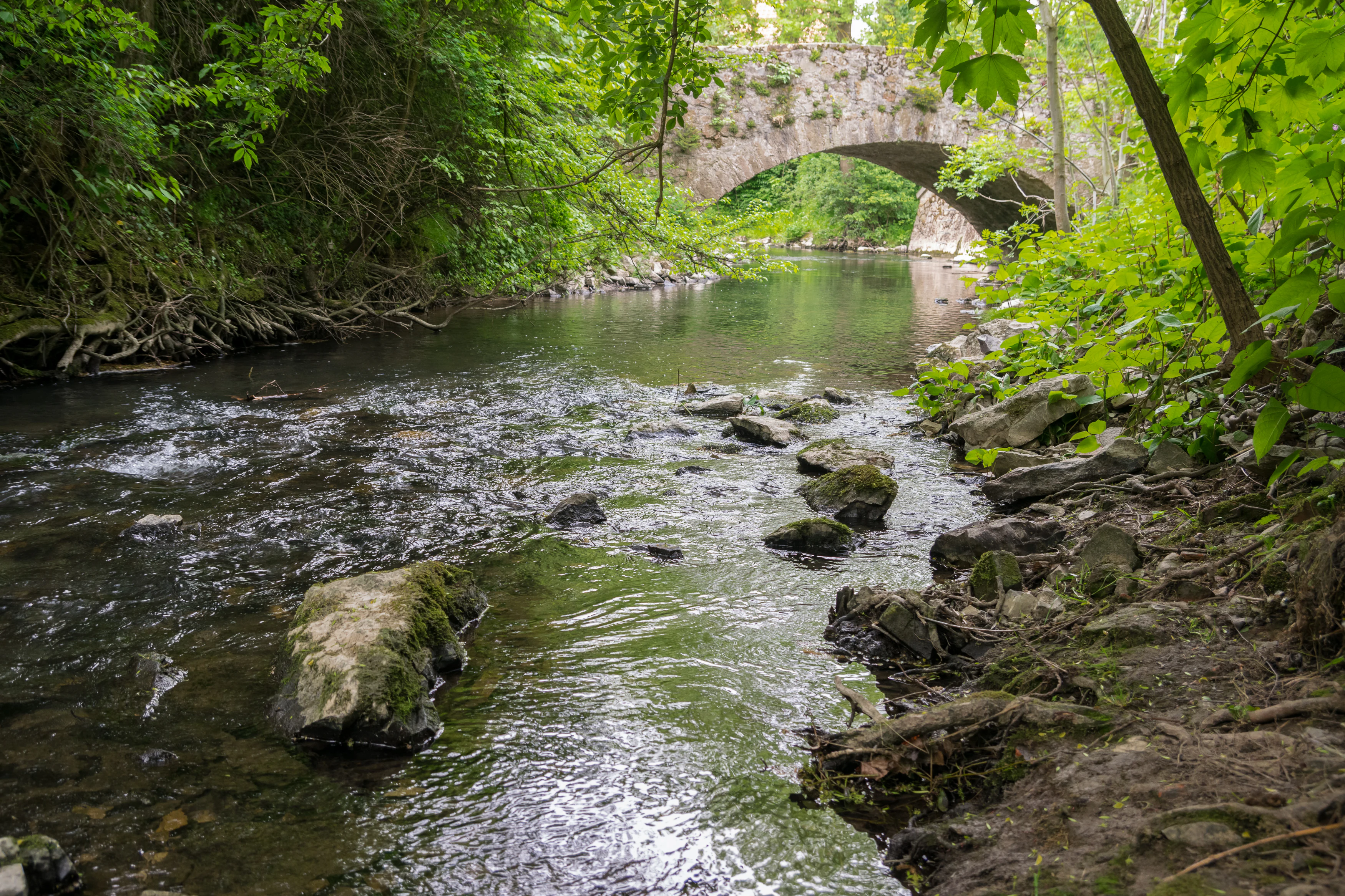
Ilse river in Lemgo
Ilse nature reserve, a tributary of the Bega river in Lemgo, Lippe district

Ilse Nature Reserve history and protected-area timeline

The Ilse Nature Reserve was formally designated in 2009 through a protection order issued by the Regierungspräsidium Detmold, the regional administrative authority for the Detmold governmental district. Its establishment reflected growing recognition in North Rhine-Westphalia of the importance of small stream corridors and their associated floodplains as refuges for species that had declined across broader agricultural landscapes.

Designated under the code LIP-094, the reserve brought together five separate sections of the Ilse valley into a single coherent protection framework. The intention was to move beyond isolated patches of conservation and instead manage the stream, its banks, and its adjoining meadows, hedges, and orchards as an interconnected ecological unit. This approach aligned with broader European conservation efforts, including the provisions of the EU Habitats Directive, which informs much of the species-specific protection referenced in the reserve's designation records.

While the reserve itself is a recent creation, the habitats it protects are long established. The Ilse stream, the traditional meadows along its banks, and the old orchard trees represent a layer of cultural landscape that has developed over generations of low-intensity farming. By formally protecting these elements, the 2009 order sought to halt further simplification of the landscape and to provide a stable framework for ongoing management and restoration.

Ilse Nature Reserve landscape and geographic character

The landscape of Ilse Nature Reserve is shaped primarily by the Ilse stream and the narrow valley through which it flows. The reserve sits within the Lipper Bergland, a landscape region defined by gentle ridges, small valleys, and a patchwork of woodland, farmland, and settlement. Within this broader context, the Ilse valley provides a contrasting band of flatter, wetter ground that supports a distinct ensemble of habitats.

The five sections of the reserve are distributed along several kilometres of the Ilse between Kirchheide in the north and Lieme in the south-west. Near Lieme the Ilse reaches its confluence with the Bega, marking a transition to the wider Begatal landscape, which is itself protected in adjacent reserves. Even within its short reach, the stream creates a varied topography of low banks, gravel and sand deposits, and small meanders that shift over time.

Above the stream channel, the valley floor includes seasonally wet meadows and pastures at different moisture levels, interspersed with taller reed and sedge stands where drainage is poorest. Riparian woodland, dominated by alder and other floodplain species, lines parts of the stream and contributes to the structurally rich appearance of the corridor. Higher and drier ground within the reserve carries hedgerows, isolated mature trees, small field copses, and traditionally managed orchard meadows, representing the older, culturally shaped layer of the local landscape.

Ilse Nature Reserve ecosystems, habitats, and plant life

Ecologically, Ilse Nature Reserve centres on a near-natural lowland stream corridor and its adjoining floodplain. The reserve's protected habitat catalogue describes a complex mosaic of aquatic, wetland, and traditional cultural landscape elements, including floodplain woodland, tall herbaceous vegetation along the banks, scattered mature trees, small field copses, meadows of varying moisture, hedgerows, gravel and sand banks, orchard meadows and orchard trees, reed and sedge stands, and riparian shrubs.

This habitat diversity is central to the reserve's ecological value. The combination of flowing water, wet soils, and structurally varied vegetation creates a wide range of microhabitats within a relatively small area. Pools and slower sections of the stream support aquatic plants, while the banks and floodplain provide breeding and feeding conditions for amphibians, dragonflies, and water insects. Reed and sedge stands offer cover for marsh birds and shelter for invertebrates, and the surrounding meadows and hedgerows extend suitable habitat into the drier parts of the valley.

The reserve's flora includes locally notable species, including bladder sedge and curled pondweed, both listed among the threatened plants of North Rhine-Westphalia. Their presence underlines the importance of clean, slow-moving water and intact floodplain soils for plants that have become scarce in modern agricultural landscapes. The reserve's mixed habitat structure also functions as a stepping stone within the wider ecological network of the Lippe district, linking the Ilse valley to the larger Bega river system.

Ilse Nature Reserve wildlife and species highlights

Wildlife is a major focus of Ilse Nature Reserve's conservation purpose. The reserve is recognised as a valuable area for amphibians, bats, dragonflies, reptiles, butterflies, and other water-dependent insects, all groups that have declined sharply across much of North Rhine-Westphalia.

Among the birdlife, the reserve supports farmland and scrub species that depend on the mix of hedgerows, wet meadows, and orchards that the protection order specifically aims to maintain. Two species highlighted in the reserve's designation records are the common whitethroat, or Dorngrasmücke, and the red-backed shrike, or Neuntöter, both of which are associated with structured, semi-open countryside and are listed among the threatened bird species of the state. Their presence indicates that the reserve continues to provide the kind of varied, insect-rich habitat these species need for breeding and feeding.

The aquatic and semi-aquatic fauna is equally central to the reserve's identity. Dragonflies and other water insects benefit from the combination of clean flowing water, gravelly stream beds, and adjoining reed and sedge stands. Amphibians use the wet meadows, ponds, and slow-moving sections of the Ilse for breeding, while bats are supported by the mix of mature trees, woodland edges, and open meadows that provides both roosting opportunities and rich foraging. Reptiles and butterflies, finally, are associated with the warmer, drier edges and the structurally varied vegetation of the valley slopes.

Ilse Nature Reserve conservation status and protection priorities

The conservation significance of Ilse Nature Reserve lies in its role as a regionally to statewide important refuge for stream and floodplain habitats in an otherwise heavily used landscape. The protection order explicitly targets the development, maintenance, and restoration of a near-natural stream and its adjoining floodplain woodland and grassland within the Wüstener hill country, the Lemgo valley basin, and the Bega floodplain.

At the broader level, the reserve contributes to the ecological coherence of protected areas in the Lippe district, sitting alongside reserves such as the Begatal, the Mittellauf der Bega, and the Passadetal. Together these sites form a network of river and stream based protected areas that safeguard water quality, characteristic floodplain species, and the natural dynamics of lowland watercourses in eastern North Rhine-Westphalia. The international recognition of the reserve is reflected in its inclusion in the World Database on Protected Areas under the WDPA ID 389795 and its IUCN Category IV classification as a Habitat and Species Management Area.

Management of the reserve addresses several linked objectives: protecting water quality and natural stream dynamics; maintaining floodplain woodland, wet meadows, reed beds, and orchards; supporting threatened plant and animal species, including those listed under the EU Habitats Directive; and preserving the traditional cultural landscape that has shaped the Ilse valley over generations. These combined aims mean the reserve functions as both a species protection site and a landscape conservation area, an approach that is typical of stream-focussed Naturschutzgebiete in the region.

Ilse Nature Reserve cultural meaning and human context

The Ilse valley carries a long history of low-intensity human use that has shaped many of the habitats now protected. Traditional hay meadows, grazed pastures, and orchard meadows along the stream reflect generations of farming practice adapted to the valley's wet soils and gentle slopes. The presence of old orchard trees within the reserve is a particularly clear marker of this cultural layer, showing how the landscape has been managed to combine fruit production with biodiversity support.

Small settlements and historic transport routes have long followed the valley, including the village of Lieme near the Ilse-Bega confluence. The reserve's five-part structure reflects the way these settlements, farms, and infrastructure divide the valley, leaving a mosaic of smaller, ecologically valuable patches rather than a single continuous corridor. This pattern is typical of long-settled rural landscapes in the Lippe region, where conservation efforts must work around existing land use rather than starting from an untouched natural baseline.

Within the Lemgo area, the reserve also carries a quiet but meaningful local value. It provides nearby residents with access to a recognisable piece of traditional Lippe countryside and serves as a local reference point for understanding the natural heritage of the Ilse and Bega rivers.

Top sights and standout views in Ilse Nature Reserve

Ilse Nature Reserve is notable for several distinctive qualities that set it apart within the network of protected areas in the Lippe district. Its five-section structure protects a connected sequence of habitats along the Ilse stream between Kirchheide and Lieme, including the important confluence area where the Ilse joins the Bega. The reserve's combination of a near-natural lowland stream, riparian alder woodland, reed and sedge stands, and traditional orchard meadows gives it an unusually rich habitat profile for such a compact site.

The reserve is also recognised for its contribution to species protection beyond its borders. Its designation records place particular emphasis on regionally and statewide significant populations of threatened plants, farmland birds, amphibians, bats, and dragonflies, and the reserve supports species listed under the EU Habitats Directive. Together with neighbouring reserves along the Bega, Ilse forms a meaningful component of the regional conservation strategy for lowland watercourses and their associated floodplains.

Best time to visit Ilse Nature Reserve

The character of Ilse Nature Reserve changes with the seasons in ways typical of small lowland stream reserves in eastern North Rhine-Westphalia. Spring is often the most lively period, when amphibian breeding activity peaks in and around the slower sections of the Ilse, hedgerows leaf out, and orchard meadows come into blossom. Warmer months bring peak dragonfly and butterfly activity along the banks and meadows, and the floodplain vegetation reaches its full height, making the stream corridor feel enclosed and green.

Autumn brings a softer, more muted atmosphere as the floodplain woodland turns colour and orchard trees bear fruit, while winter offers quieter conditions and clearer views along the stream and across the meadows. Because the reserve is small and combines open meadow with woodland, visits at any time of year can reveal different aspects of its habitat mosaic, though wetter periods will make some of the lower-lying sections more difficult to walk through.

Monthly climate preview

Track monthly precipitation averages and historical temperature ranges for Ilse.

Ilse Climate Normals and Long-Term Annual Temperature Patterns

Long-term NASA measurements establish the baseline temperature and monthly precipitation rhythm across representative coordinates in Ilse. Reviewing complete twelve-month normals provides detailed context on long-term climate variations throughout the terrain.
Annual mean9 °C
1 °C18 °C
Jan
Feb
Mar
Apr
May13°
Jun16°
Jul18°
Aug18°
Sep14°
Oct
Nov
Dec
Warmest month
July

18.1 °C

Coolest month
January

0.5 °C

Wettest month
December

2.6 mm/day

Driest month
April

1.6 mm/day

Park location guide

Geography guide, regional context, and park location map for Ilse Nature Reserve

Ilse Nature Reserve park geography, regions, and map view in Germany

Understand where Ilse Nature Reserve sits in Germany through a broader geographic reading of the surrounding landscape, nearby location context, and its mapped position within the national park landscape.

How Ilse Nature Reserve fits into Germany

Germany is a federal republic in Western and Central Europe with a population of over 83 million across sixteen constituent states. It is Europe's largest economy by nominal GDP and a major global exporter and importer. The capital is Berlin, and the country borders Denmark, Poland, Czech Republic, Austria, Switzerland, France, Luxembourg, Belgium, and the Netherlands.

Wider geography shaping Ilse Nature Reserve in Germany

Germany is located in Western and Central Europe, spanning 357,022 km². It borders Denmark to the north, Poland and the Czech Republic to the east, Austria and Switzerland to the south, and France, Luxembourg, Belgium, and the Netherlands to the west. The country has coastlines on the Baltic Sea and North Sea to the north, with the Alps located in the southern region.

Map view of Ilse Nature Reserve

Use this park location map to pinpoint Ilse Nature Reserve in Germany, understand its exact geographic position, and read its mapped placement within the surrounding landscape more clearly.

Pigeon | © OpenStreetMap contributors

Location context for Ilse Nature Reserve

North Rhine-Westphalia

Explore detailed imagery of lowland waterways, wet floodplains, and riparian woodlands in Germany

Ilse Photos and Landscape Scenery: Visualizing Protected Stream Habitats

Visual documentation of Ilse reveals the intricate terrain of near-natural stream corridors, wet meadows, and traditional orchard habitats across the Lippe highlands. Examining these protected landscape photographs helps visitors understand the ecological structure and environmental diversity defining the local nature reserve.

Ilse river in Lemgo

Park atlas

Discover related reserves and connected river corridors across the Lippe highlands

Parks Near Ilse: Compare Nearby Protected Areas and Regional Landscapes

Browse other protected areas and lowland stream reserves located near Ilse within the surrounding regional landscape. Compare adjacent habitats and connected conservation corridors to understand the broader ecological network of the Lippe district.
Nature reserveNordrhein-Westfalen
About 8.7 km away#1 closest

North

Kleiner Selberg Nature Reserve: Protected Landscape and Geographic Mapping

Essential geographic context for the Lipper Bergland protected areas

Kleiner Selberg stands as a prominent hill and nature reserve within the Kreis Herford region. Its landscape is defined by a dense population of juniper shrubs and restored heathland, offering a vital ecological corridor in the Weserbergland. Explore the spatial arrangement of its woodland patches and pasture slopes that characterize this protected hill environment.

Area
0.136 km²
Established
1971
Relief
Mountain
Climate
Temperate
Nature reserveKreis Lippe
About 10 km away#2 closest

East

Quellbereich der Osterkalle: Protected Nature Reserve and Kastental Valley Atlas

A preserved stream valley landscape in Kreis Lippe

Quellbereich der Osterkalle is a protected nature reserve encompassing roughly 23 hectares of stream valley and hillside habitat. Defined by its characteristic box-shaped Kastental profile, the reserve maintains a near-natural brook system surrounded by riparian trees, wet meadows, and traditional sheep-grazed slopes within the Kreis Lippe district.

Area
0.23 km²
Established
1995
Relief
Upland
Scope
Terrestrial
Nature reserveNordrhein-Westfalen
About 10 km away#3 closest

West

Holzhauser Bruch Nature Reserve: Protected Wetland and Riparian Geography in Nordrhein-Westfalen

Mapping lowland bog and meandering river corridors

Holzhauser Bruch in Nordrhein-Westfalen preserves a compact yet ecologically vital riverine landscape. Its terrain contrasts wet alder-dominated swamp forests with drier, sandy upland slopes. This summary explores the geographic boundary of the reserve, highlighting its role as a representative fragment of the Werre valley habitat system.

Area
0.4 km²
Established
2002
Nature reserveNordrhein-Westfalen
About 11 km away#4 closest

Southeast

Marpetal mit Passade und Zufluesse: Nature Reserve and Stream Valley Geography

Protected riparian landscapes in the district of Lippe

Marpetal mit Passade und Zufluesse consists of an 89-hectare nature reserve that safeguards the ecological integrity of small river valleys. Its terrain, defined by the Passade and Marpe streams, connects with adjacent protected lands to maintain a continuous corridor of floodplain and slope habitats within the rural Westphalian landscape.

Area
0.889 km²
Established
2005
Nature reserveNorth Rhine-Westphalia
About 11 km away#5 closest

West

Heipker See Nature Reserve: Geographic Mapping of the Werre River Valley Landscape

Protected riparian habitat in North Rhine-Westphalia, Germany

Heipker See offers a detailed look into the landscape composition of an eastern Westphalian nature reserve. The protected area features a distinct concentration of stillwater, stream, and river-corridor habitats, providing essential space for migratory birds and demonstrating the ecological significance of small-scale landscape connectivity in the Werre valley region.

Area
0.246 km²
Established
1998
IUCN
IV
Relief
Lowland
Nature reserveNordrhein-Westfalen
About 13 km away#6 closest

Northwest

In der Masch Nature Reserve: Mapped Floodplain Geography in Nordrhein-Westfalen

Protected nature reserve with rare lowland meadow habitats.

In der Masch offers a focused look at protected lowland river-meadow terrain within Germany. This 23-hectare nature reserve in Nordrhein-Westfalen protects interconnected oat-grass grasslands, riparian wood fringes, and historical boundary markers, providing a distinct study in regional floodplain topography and habitat preservation.

Area
0.23 km²
Established
2002
IUCN
IV
Nature reserveNorth Rhine-Westphalia
About 15 km away#7 closest

Northwest

Naturschutzgebiet Mittelbach Nature Reserve: Mapped Protected Landscapes in Vlotho

Classic Siek stream valley geography and riparian woodland habitats

The Naturschutzgebiet Mittelbach is a protected area in eastern Westphalia that defines the local landscape with its deeply cut moisture-rich valley. This site serves as a vital reference for the traditional Ravensberger Siek morphology, preserving a compact ecological network of sedge communities, beech forest patches, and riparian alder stands along a two-kilometer stream stretch.

Area
0.341 km²
Established
1998
Relief
Upland
Climate
Temperate
Nature reserveNordrhein-Westfalen
About 16 km away#8 closest

West

Windwehetal Nature Reserve: Mapped Protected Brook Valley in Nordrhein-Westfalen

Dynamic stream geography and woodland protected landscapes

Windwehetal represents a compact yet ecologically significant protected area in the German federal state of North Rhine-Westphalia. The reserve showcases near-natural stream dynamics, including undercut slopes reaching three metres, alongside a complex mosaic of gallery woodlands, damp grasslands, and beech forests that define the valley floor and surrounding ridges.

Area
0.565 km²
Established
1998
IUCN
IV
Relief
Upland

Common questions about visiting, size, designation, and location context for Ilse Nature Reserve

Ilse Nature Reserve FAQs for park facts, access, geography, and protected area context

Find quick answers about Ilse Nature Reserve, including protected-area facts, park geography, trail and visitor context, and how the park fits into its surrounding country and regional landscape.
MoriAtlas Explorer

Continue Your Protected Areas Search Across the Global Atlas

Deepen your exploration by continuing the structured search for national parks and protected areas worldwide. Utilize the comprehensive filtering capabilities to compare different conservation landscapes and refine your understanding of global park geography. Discover more about the distribution and characteristics of protected natural areas.

Global natural geography