
Mori Atlas logo
Nature reserveIn der Masch

Trace the meadowland mosaic and historical boundary markers of this Werra floodplain site.

In der Masch Nature Reserve: Analyzing Protected Floodplain Landscapes and Regional Geography

(Naturschutzgebiet "In der Masch")

In der Masch stands as a representative protected landscape within the Werra floodplain of Nordrhein-Westfalen. This 23-hectare nature reserve preserves a rare mix of fresh oat-grass meadows, riparian woodlands, and ponds, offering a clear window into the post-glacial river valley terrain of the Lippe district. Through mapped boundaries and topographic data, visitors can understand the interplay between the site's habitat mosaic and its historic border markers, including surviving Landesgrenzsteine from the Prussian era.

nature reservefloodplainmeadowlandwet grasslandhabitat mosaicponds and still water
Digital illustration of a scenic valley with towering rocky cliffs, a forest of evergreen trees, a winding river, and a distant waterfall under a cloudy sky.

In der Masch

Nature reserve

Park overview

Structured park overview, official facts, and landscape profile for In der Masch

In der Masch park facts, protected area profile, and essential visitor context

Review the core facts for In der Masch, including designation, size, terrain, visitor scale, habitats, and operating context in one park-focused overview.

About In der Masch

In der Masch is a compact nature reserve situated west of the historic spa town of Bad Salzuflen in the Lippe district of eastern North Rhine-Westphalia. The roughly 23-hectare protected area lies between the Herford–Himmighausen railway line to the north and Ziegelstraße to the south, occupying part of the lower Werra valley. The name "Masch" itself refers to a post-glacial landscape form typical of northwestern German rivers, low-energy floodplain terrain shaped by sediment deposition over thousands of years. The reserve was officially designated in 2002 under the designation LIP-042 and is managed as an IUCN Category IV habitat and species management area.

Ecologically, In der Masch represents a microcosm of the kind of structured floodplain landscape that has become rare across the wider Werra watershed. The reserve's core is formed by large, continuous stretches of fresh and partially moist Glatthaferwiesen, a traditional type of mesotrophic meadow that once dominated German river valleys but has been heavily reduced by modern agriculture. These open grasslands are punctuated by ponds, small still-water bodies, riparian woodland strips, hedgerows, and shrub groups, creating a mosaic of habitats that increases both ecological value and visual variety within a relatively small footprint.

The reserve's significance lies less in its size than in the quality and continuity of its habitats. Large, well-preserved floodplain meadows of this kind are increasingly scarce in the Werra floodplain, making the protected area a local conservation priority. Visitors and researchers value the site as a place where the layered structure of a traditional German river valley landscape; open grassland, scrub, water, and woodland edge; is preserved in close proximity to an urban center.

Protection and recognition

Examining documented conservation measures and international recognition data

In der Masch Protection Status and Official Designation Records

In der Masch maintains verified records detailing official protection status, management frameworks, and environmental governance parameters. Systematic data collation provides structured oversight of conservation parameters and recognized designation histories for researchers.

Protection details

WDPA ID
329464
Park context

Deeper park guide and search-rich context for In der Masch

In der Masch history, landscape, wildlife, and travel context

Explore In der Masch through its history, landscape character, ecosystems, wildlife, conservation priorities, cultural context, and seasonal travel timing in a structured park guide built for atlas discovery and search intent.

Why In der Masch stands out

In der Masch is best known for its extensive, interconnected meadows of fresh and partially moist oat-grass grassland (Glatthaferwiesen) set within the Werra floodplain, an increasingly rare habitat type in the region. The reserve also features a richly structured mosaic of hedgerows, scrub, ponds, and riparian woodlands that together create unusually high habitat diversity for such a small protected area. Two historical Landesgrenzsteine, boundary stones from the former border between the Principality of Lippe and the Free State of Prussia, add a small but distinctive cultural layer to the landscape.
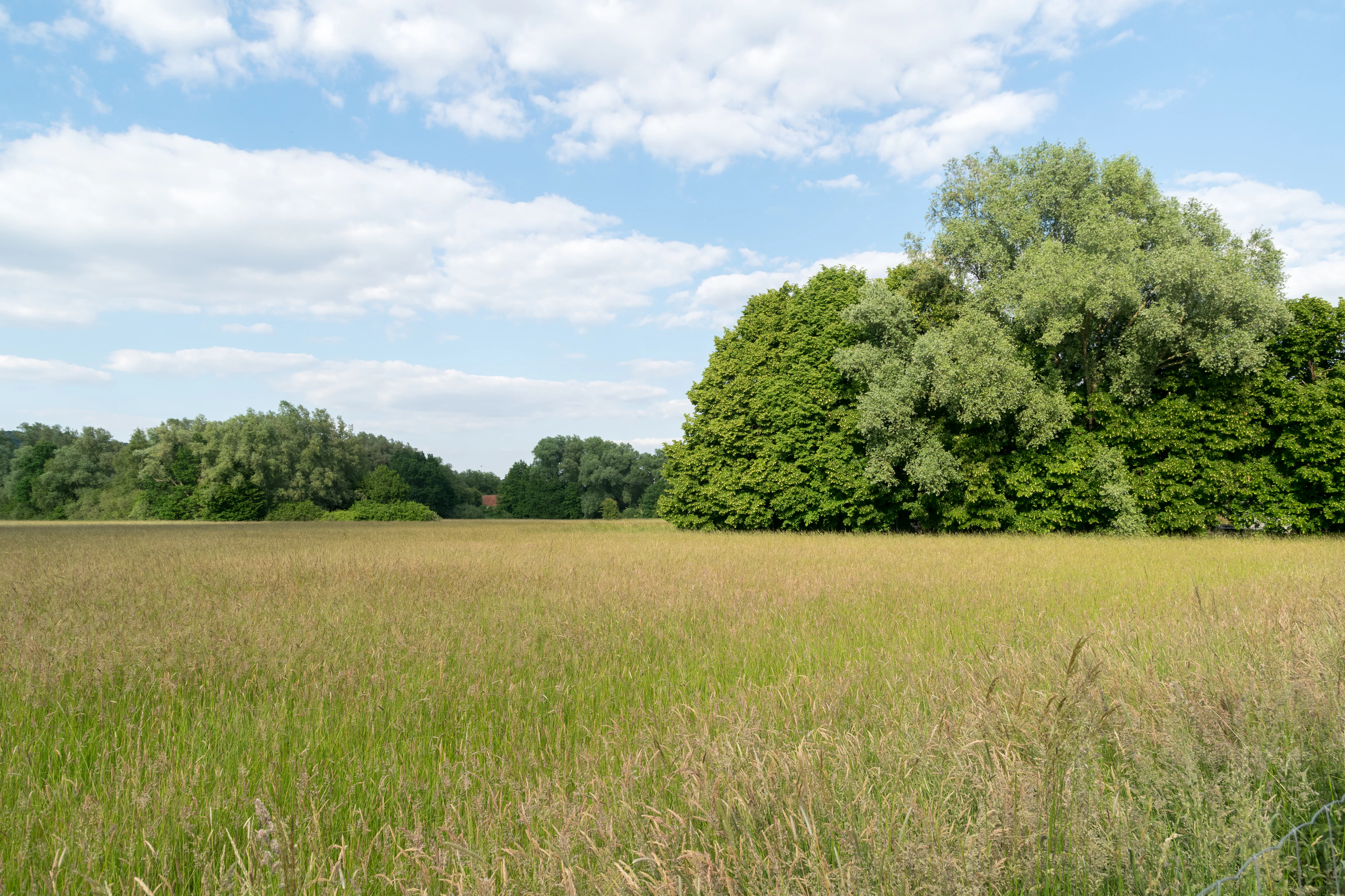
A wide view of a sunlit grassy meadow in the foreground leading to a dense line of trees under a blue sky with scattered clouds.
Open meadows bordered by mature trees in the In der Masch nature reserve.

In der Masch history and protected-area timeline

In der Masch was formally designated as a nature reserve in 2002 by the regional authority in Detmold (Regierungspräsidium Detmold), which serves the former Regierungsbezirk Detmold area of North Rhine-Westphalia. The reserve's formal designation number, LIP-042, places it within a broader network of protected sites established across the Lippe district over recent decades.

Beyond its modern conservation history, the landscape of In der Masch carries older cultural markings in the form of two surviving Landesgrenzsteine, historical boundary stones that once marked the border between the Principality of Lippe and neighboring territories. Two such stones remain within or adjacent to the reserve: Stone 2, a rectangular block with a rounded head bearing the Lippische Rose and the Prussian Eagle, and Stone 5, which additionally carries the year 1800. These stones are listed as architectural monuments in the heritage registers of Bad Salzuflen, Herford, and Vlotho, giving the reserve a small but tangible historical dimension alongside its ecological role.

In der Masch landscape and geographic character

The landscape of In der Masch is shaped by quiet floodplain topography, a flat to gently undulating river-valley terrain typical of northwestern Germany's post-glacial lowlands. The reserve sits on the western edge of Bad Salzuflen, bounded to the north by the Herford–Himmighausen railway line and to the south by Ziegelstraße, comfortably small enough to experience on foot yet varied enough to feel layered and dynamic. The Werra floodplain's characteristic low relief gives the reserve an open, horizontal feel, where the eye travels easily across grassland toward distant tree lines and water.

Within this broadly flat setting, the reserve contains most of the classic textural elements of a lowland floodplain. Open oat-grass meadows dominate the central portions, while the western part of the reserve is interrupted by smaller-scale hedges, scrub patches, and shrub groups that break up the otherwise continuous grassland. Ponds and small still waters, together with narrow strips of riparian woodland running along the wetter margins, add vertical structure and tonal variation. The combination of meadow, hedge, scrub, and water produces a landscape that blends agricultural openness with the more sheltered character of wetland woodland edges, a small-scale patchwork of valley countryside preserved within the broader Werra plain.

In der Masch ecosystems, habitats, and plant life

Ecologically, In der Masch is a textbook example of a richly structured lowland floodplain biotope complex. Its dominant habitat is the Glatthaferwiese, a fresh to slightly moist mesotrophic meadow type that historically characterIsed European river valleys. Where the meadows meet the wetter edges of the floodplain, the open grassland grades into damp meadow and moist grassland communities, and in some areas to fallow wet grassland (Nass- und Feuchtgrünland). This gradient from dry to wet conditions supports a wide range of plants and the invertebrates that depend on them.

Hedgerows, shrub groups, and small groves of trees such as hornbeam (Hainbuche) and pedunculate oak (Stieleiche) dissect the western part of the reserve, providing woody structure that is otherwise rare in the surrounding agricultural landscape. Ponds and small still waters within the reserve host aquatic and wetland plants including white water lily (Weiße Seerose), yellow flag iris (Sumpf-Schwertlilie), flowering rush (Schwanenblume), and broad-leaved cattail (Breitblättriger Rohrkolben). Riparian willows such as crack willow (Bruch-Weide), white willow (Silber-Weide), grey willow (Asch-Weide), and goat willow (Salweide) fringe the wetter margins. Together, these habitat types form a small but functionally complete example of a traditional northwestern German valley ecosystem.

In der Masch conservation status and protection priorities

In der Masch is protected under German nature reserve (Naturschutzgebiet) law and is formally classified as an IUCN Category IV habitat and species management area, a designation that emphasizes active protection of specific species and habitat mosaics rather than full wilderness preservation. The core conservation goal of the reserve is to preserve and improve a biotope complex in the Werra floodplain that includes extensive grassland habitat and remnants of typical floodplain structures such as ponds and riparian vegetation.

The reserve's particular conservation value lies in the size and continuity of its floodplain meadows, qualities that have become rare in the surrounding Werra floodplain where modern land use has fragmented and reduced similar habitats. By maintaining large, connected grassland areas alongside hedges, still waters, and riparian woodland, In der Masch provides a functioning refuge for meadow- and wetland-dependent species and helps preserve a representative example of a habitat type that has been heavily depleted across the wider region. Its modest scale makes the site a useful local case study in floodplain habitat protection within an intensively used landscape.

In der Masch cultural meaning and human context

The most distinctive cultural feature of the In der Masch landscape is the presence of two Landesgrenzsteine, historic boundary stones that once marked the border between the Principality of Lippe and the Free State of Prussia, the successor in this area of the older County of Ravensberg. Around fifty of these stones still survive along what was once the principality's eastern border, and they are protected as architectural monuments in Bad Salzuflen, Herford, and Vlotho.

The two stones in or near In der Masch are rectangular with rounded heads and bear the Lippische Rose together with the Prussian Eagle; one of them additionally carries the year 1800. Although small in scale, these stone landmarks connect the modern nature reserve to the territorial and political history of the region and place the site within a centuries-old cultural landscape that predates its 2002 conservation designation.

Top sights and standout views in In der Masch

The highlights of In der Masch center on the interplay of meadow, hedge, water, and small woodland that defines the reserve's character. The continuous and unusually well-preserved Glatthaferwiesen in the Werra floodplain are the standout ecological feature, offering a rare glimpse of a habitat type that has largely disappeared from the surrounding valley. Supplementing these open grasslands, the ponds, riparian willows, and scrub patches create a layered, high-diversity floodplain mosaic within a remarkably compact area.

Two surviving Landesgrenzsteine from the old Lippe-Prussian border, one of them dated 1800, add a tangible historical element to the landscape and connect the reserve to the territorial history of the region. Together, the ecological richness and small-scale historical markers make In der Masch a quietly distinctive protected site within the Lippe district's broader network of nature reserves.

Best time to visit In der Masch

In der Masch is best appreciated in late spring and summer, when the floodplain meadows reach their full botanical richness and the extensive Glatthaferwiesen are in active growth. Warmer months also bring out the wetland vegetation around the reserve's ponds and along its riparian edges, while the open, flat valley setting makes the grasslands pleasant to observe in clear weather.

Autumn can also be a rewarding time to visit, when the structural diversity of the site, hedges, shrubs, willows, and water bodies, becomes more visually prominent against the fading grasses, though the meadow flora itself is less striking than in summer. Winters tend to be quieter and more muted, with limited visibility of the seasonal character of the meadows; visitors at this time will encounter mainly the woody and structural elements of the landscape. Weather conditions in the open floodplain can be exposed, so calmer, drier days are generally more comfortable for exploring the reserve on foot.

Monthly climate preview

Long-term representative point measurements tracking monthly climate patterns in Nordrhein-Westfalen

In der Masch Climate Normals: Annual Temperature and Precipitation Rhythm

Representative coordinates record measured monthly temperature swings from sub-zero winter minimums to warm summer maximums alongside consistent daily precipitation rates. Detailed multi-month climate normals provide a complete record of long-term meteorological trends across the protected terrain.
Annual mean9 °C
1 °C18 °C
Jan
Feb
Mar
Apr
May13°
Jun16°
Jul18°
Aug18°
Sep14°
Oct
Nov
Dec
Warmest month
July

18.1 °C

Coolest month
January

0.5 °C

Wettest month
December

2.6 mm/day

Driest month
April

1.6 mm/day

Park location guide

Geography guide, regional context, and park location map for In der Masch

In der Masch park geography, regions, and map view in Germany

Understand where In der Masch sits in Germany through a broader geographic reading of the surrounding landscape, nearby location context, and its mapped position within the national park landscape.

How In der Masch fits into Germany

Germany is a federal republic in Western and Central Europe with a population of over 83 million across sixteen constituent states. It is Europe's largest economy by nominal GDP and a major global exporter and importer. The capital is Berlin, and the country borders Denmark, Poland, Czech Republic, Austria, Switzerland, France, Luxembourg, Belgium, and the Netherlands.

Wider geography shaping In der Masch in Germany

Germany is located in Western and Central Europe, spanning 357,022 km². It borders Denmark to the north, Poland and the Czech Republic to the east, Austria and Switzerland to the south, and France, Luxembourg, Belgium, and the Netherlands to the west. The country has coastlines on the Baltic Sea and North Sea to the north, with the Alps located in the southern region.

Map view of In der Masch

Use this park location map to pinpoint In der Masch in Germany, understand its exact geographic position, and read its mapped placement within the surrounding landscape more clearly.

Pigeon | © OpenStreetMap contributors

Location context for In der Masch

Nordrhein-Westfalen

Protected area views highlighting floodplain habitats and lowland valley terrain

In der Masch Photos and Landscape Scenery Visual Exploration

Visual documentation of In der Masch reveals the flat river-meadow terrain and interconnected oat-grass grasslands of the Werra floodplain. Photographic records capture the mosaic of hedgerows, ponds, and riparian woodlands that define the ecological character of the protected reserve.

A wide view of a sunlit grassy meadow in the foreground leading to a dense line of trees under a blue sky with scattered clouds.

A triangular green and white nature reserve sign on a metal pole stands in a mowed meadow beside a paved path.

Park atlas

Compare adjacent river valley reserves and regional protected habitats

Explore Other Parks Near In der Masch and Surrounding Protected Landscapes

Browse nearby protected areas and lowland valley reserves to compare the ecological diversity surrounding In der Masch. Extending geographic analysis across adjacent floodplain habitats reveals broader regional patterns in local conservation terrain.
Watercolor illustration showing a calm lake surrounded by green trees and vegetation with rolling hills and a pink sky in the background
Nature reserveNorth Rhine-Westphalia
About 6.4 km away#1 closest

South

Heipker See Nature Reserve: Geographic Mapping of the Werre River Valley Landscape

Protected riparian habitat in North Rhine-Westphalia, Germany

Heipker See offers a detailed look into the landscape composition of an eastern Westphalian nature reserve. The protected area features a distinct concentration of stillwater, stream, and river-corridor habitats, providing essential space for migratory birds and demonstrating the ecological significance of small-scale landscape connectivity in the Werre valley region.

Area
0.246 km²
Established
1998
IUCN
IV
Relief
Lowland
A pale, soft-toned watercolor painting of a rolling landscape with green fields, forested areas, and a small winding stream under a light sky.
Nature reserveNordrhein-Westfalen
About 7.3 km away#2 closest

South

Holzhauser Bruch Nature Reserve: Protected Wetland and Riparian Geography in Nordrhein-Westfalen

Mapping lowland bog and meandering river corridors

Holzhauser Bruch in Nordrhein-Westfalen preserves a compact yet ecologically vital riverine landscape. Its terrain contrasts wet alder-dominated swamp forests with drier, sandy upland slopes. This summary explores the geographic boundary of the reserve, highlighting its role as a representative fragment of the Werre valley habitat system.

Area
0.4 km²
Established
2002
Nature reserveNordrhein-Westfalen
About 8.9 km away#3 closest

Southwest

Windweheniederung Nature Reserve: Geographic Atlas of an East Westphalian Floodplain

Riparian ecosystems and protected valley land mapping

Windweheniederung represents a specialized nature reserve in Nordrhein-Westfalen that centers on the natural morphology of the Windwehe stream. This protected area provides a critical refuge for wetland-dependent species through its alder-ash woodland and reed-fringed pools. Explore the structural geography of this lowland catchment and understand its role in maintaining functional floodplains amidst a heavily developed regional environment.

Area
0.297 km²
Established
1991
IUCN
IV
A watercolor illustration of a calm stream flowing through a green valley with trees and gentle hills in the background.
Nature reserveNorth Rhine-Westphalia
About 9.2 km away#4 closest

Northeast

Naturschutzgebiet Mittelbach Nature Reserve: Mapped Protected Landscapes in Vlotho

Classic Siek stream valley geography and riparian woodland habitats

The Naturschutzgebiet Mittelbach is a protected area in eastern Westphalia that defines the local landscape with its deeply cut moisture-rich valley. This site serves as a vital reference for the traditional Ravensberger Siek morphology, preserving a compact ecological network of sedge communities, beech forest patches, and riparian alder stands along a two-kilometer stream stretch.

Area
0.341 km²
Established
1998
Relief
Upland
Climate
Temperate
Nature reserveNordrhein-Westfalen
About 9.5 km away#5 closest

Southwest

Windwehetal Nature Reserve: Mapped Protected Brook Valley in Nordrhein-Westfalen

Dynamic stream geography and woodland protected landscapes

Windwehetal represents a compact yet ecologically significant protected area in the German federal state of North Rhine-Westphalia. The reserve showcases near-natural stream dynamics, including undercut slopes reaching three metres, alongside a complex mosaic of gallery woodlands, damp grasslands, and beech forests that define the valley floor and surrounding ridges.

Area
0.565 km²
Established
1998
IUCN
IV
Relief
Upland
A watercolor illustration of a rural landscape with a single prominent tree in the foreground, green hills in the distance, and soft fields in between.
Nature reserveNordrhein-Westfalen
About 11 km away#6 closest

East

Kleiner Selberg Nature Reserve: Protected Landscape and Geographic Mapping

Essential geographic context for the Lipper Bergland protected areas

Kleiner Selberg stands as a prominent hill and nature reserve within the Kreis Herford region. Its landscape is defined by a dense population of juniper shrubs and restored heathland, offering a vital ecological corridor in the Weserbergland. Explore the spatial arrangement of its woodland patches and pasture slopes that characterize this protected hill environment.

Area
0.136 km²
Established
1971
Relief
Mountain
Climate
Temperate
A watercolor painting showing a stylized landscape with rolling green hills, a winding path or stream, and distant purple mountains against a white background.
Nature reserveNorth Rhine-Westphalia
About 13 km away#7 closest

Southeast

Ilse Nature Reserve: Protected Stream Corridor and Floodplain Geography in North Rhine-Westphalia

Mapped riparian habitats and regional conservation landscape context.

Ilse Nature Reserve serves as a critical protected corridor within the Lippe district, spanning five distinct sections along the Ilse stream. The reserve is defined by its near-natural watercourse, wet meadows, and traditional orchard remnants that safeguard species-rich habitats. This geographic focus provides essential insights into the conservation of lowland stream ecosystems and their role in maintaining the ecological connectivity of the broader Bega river valley.

Area
0.142 km²
Established
2009
IUCN
IV
Relief
Upland
Nature reserveNorth Rhine-Westphalia
About 21 km away#8 closest

Northeast

Wittekindsberg Nature Reserve: Mapping Protected Forests and Jurassic Cliffs in Germany

A conservation-focused geographic analysis of the Wiehengebirge ridge

Wittekindsberg Nature Reserve represents a key protected landscape in northeastern North Rhine-Westphalia. Spanning the crest of the Wiehengebirge, the area is characterized by a mosaic of beech-dominated forests and Jurassic-age geological features. This atlas entry provides essential context on the reserve's topography, cliff-face habitats, and its role as a representative ecological site within the larger Natura 2000 network of the region.

Area
1.143 km²
Established
1990
IUCN
IV
Relief
Mountain

Common questions about visiting, size, designation, and location context for In der Masch

In der Masch FAQs for park facts, access, geography, and protected area context

Find quick answers about In der Masch, including protected-area facts, park geography, trail and visitor context, and how the park fits into its surrounding country and regional landscape.
MoriAtlas Explorer

Continue Your Protected Areas Search Across the Global Atlas

Deepen your exploration by continuing the structured search for national parks and protected areas worldwide. Utilize the comprehensive filtering capabilities to compare different conservation landscapes and refine your understanding of global park geography. Discover more about the distribution and characteristics of protected natural areas.

Global natural geography