Mori Atlas logo
Wildlife reserveIndian Heaven Wilderness

Traverse the lake-rich volcanic geography and diverse terrain of the southern Washington Cascades.

Indian Heaven Wilderness: A Mapped Exploration of Volcanic Plateaus and Protected Landscapes

Indian Heaven Wilderness represents a distinct volcanic field within the southern Washington Cascades, characterized by a forested plateau, shield volcanoes, and over 150 high-elevation lakes and marshes. This protected landscape preserves the intricate relationship between geologic heritage and Indigenous stewardship. Explore the map of this wilderness to understand the volcanic profiles of Lemei Rock, East Crater, and the sprawling meadow networks that define this unique Cascade terrain.

volcanic landscapeshield volcanocinder conealpine lakeswilderness areaPacific Northwest

Indian Heaven Wilderness

Wildlife reserve

Park overview

Structured park overview, official facts, and landscape profile for Indian Heaven Wilderness

Indian Heaven Wilderness park facts, protected area profile, and essential visitor context

Review the core facts for Indian Heaven Wilderness, including designation, size, terrain, visitor scale, habitats, and operating context in one park-focused overview.

About Indian Heaven Wilderness

Indian Heaven Wilderness is a federal wilderness area in Skamania County, southwestern Washington, embedded within the Gifford Pinchot National Forest. The designation preserves 20,782 acres of a broad, forested plateau shaped by extensive volcanic activity. The terrain consists of overlapping shield volcanoes, spatter cones, and cinder cones, with the highest point at Lemei Rock, whose summit crater now holds Lake Wapiki. The plateau averages around 4,500 feet in elevation, and the low-relief landscape features more than 150 small lakes, ponds, and marshes woven between rocky volcanic peaks and open meadows.

The wilderness sits within the larger Indian Heaven volcanic field, a 230-square-mile Quaternary basalt region that forms part of the southern Washington Cascades. About 60 eruptive centers line a roughly 19-mile-long fissure zone that trends north-northeast across the field. The wilderness also includes dramatic young volcanic features such as Big Lava Bed, the result of the most recent eruptive activity about 8,200 years ago. This volcanic foundation gives the area its distinctive combination of rounded summits, lava flows, and many small basins of standing water.

The plateau is not only a natural feature but also a deeply meaningful cultural landscape. For thousands of years, it has been revered as a gathering place by Indigenous peoples, including the Yakama, Klickitat, Cascades, Wasco, Wishram, and Umatilla tribes. Periodic burning by Native communities shaped the meadow ecology that today still produces abundant huckleberries.

Today, Indian Heaven offers a quiet but richly varied experience of the Cascades. The Pacific Crest Trail runs north to south through the heart of the area, and side trails lead to alpine lakes, volcanic cones, and panoramic viewpoints. In a single view, hikers can see Mount Adams, Mount Hood, Mount St. Helens, and Mount Rainier, a rare and visually powerful panorama in the lower forty-eight states. The combination of dense lakes, sweeping volcanic vistas, old-growth forests, and cultural heritage makes Indian Heaven one of the more ecologically and culturally distinctive wilderness areas in Washington state.

Quick facts and research context for Indian Heaven Wilderness

Indian Heaven Wilderness is a roughly 20,782-acre designated wilderness located entirely within the Gifford Pinchot National Forest in Skamania County, southwestern Washington. It was designated as wilderness in 1984 and is administered by the U.S. Forest Service.

The terrain centers on a volcanic plateau averaging around 4,500 feet in elevation, capped by overlapping shield volcanoes, spatter cones, and cinder cones. The wilderness contains at least 150 small lakes, ponds, and marshes, along with meadows that are ecologically and culturally important. The area is part of the Indian Heaven volcanic field, a 230-square-mile Quaternary basalt field that stretches along the southern Washington Cascades, with the most recent volcanic activity occurring roughly 8,200 years ago at Big Lava Bed.

Protection and recognition

Examine documented terrestrial conservation metrics and management scope.

Indian Heaven Wilderness Protection Status and Territorial Designation

Indian Heaven Wilderness holds a documented terrestrial protection status within public lands. Review the verified designation history and formal recognition parameters governing this protected area.

Protection details

Protection scope
Terrestrial
Park context

Deeper park guide and search-rich context for Indian Heaven Wilderness

Indian Heaven Wilderness history, landscape, wildlife, and travel context

Explore Indian Heaven Wilderness through its history, landscape character, ecosystems, wildlife, conservation priorities, cultural context, and seasonal travel timing in a structured park guide built for atlas discovery and search intent.

Why Indian Heaven Wilderness stands out

Indian Heaven Wilderness is best known for its unusually dense concentration of small lakes and volcanic landforms set on a forested high plateau. With more than 150 lakes, ponds, and marshes scattered among the peaks and meadows, the wilderness offers a distinctive Cascade landscape that feels more like a high-country labyrinth than a typical mountain wilderness. The wilderness is also known for sweeping volcanic vistas. From many of its peaks, hikers can see four major Cascade volcanoes at once: Mount Adams, Mount Hood, Mount St. Helens, and Mount Rainier. Combined with the Pacific Crest National Scenic Trail passing through its length and its rich huckleberry meadows, the area stands out as both a culturally and ecologically distinctive Pacific Northwest wilderness.
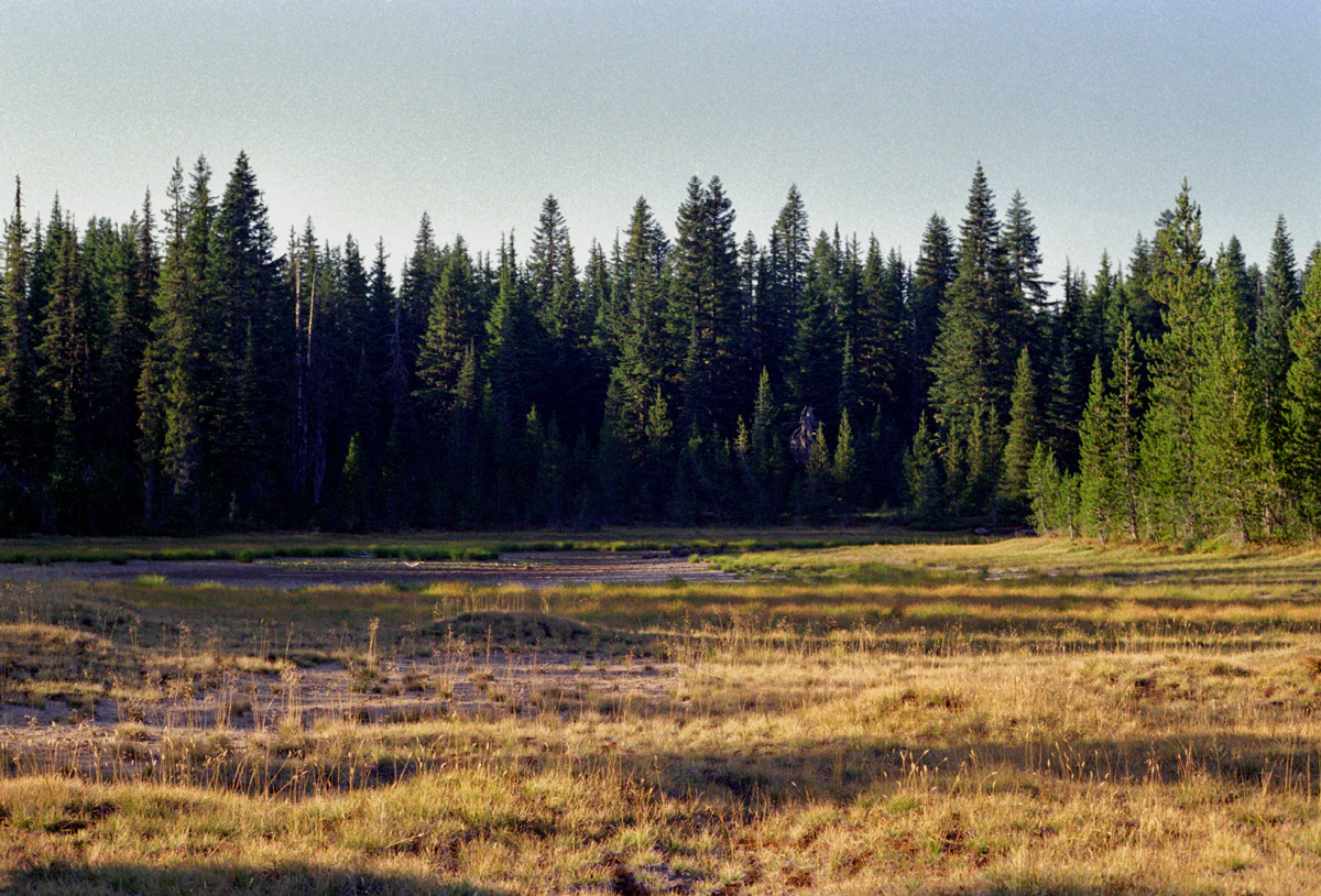
A wide, golden-brown meadow bordered by a thick, dark green forest of coniferous trees under a clear, light sky.
The Indian Racetrack meadow within Indian Heaven Wilderness, framed by a dense coniferous forest.

Indian Heaven Wilderness history and protected-area timeline

Though its modern wilderness designation is relatively recent, Indian Heaven has a long human history stretching back roughly nine thousand years. Indigenous peoples of the Columbia Plateau and Pacific Northwest, including the Yakama, Klickitat, Cascades, Wasco, Wishram, and Umatilla tribes, traveled to the area for generations to gather huckleberries, fish, and hunt game. The plateau was known by Native peoples as 'Sahalee Tyee,' reflecting its enduring cultural importance as a high-country gathering ground.

These communities also shaped the ecology of the landscape itself. By setting fires across the meadows in a managed cycle, they encouraged the growth of huckleberry bushes and maintained the open meadow systems that still characterize parts of the wilderness today. The archaeological remains in the area, including the so-called Indian racetrack near the Race Track Lakes, reflect this long and ongoing heritage of human presence and land stewardship.

The wilderness itself was formally designated in 1984 after years of advocacy for the protection of the Indian Heaven volcanic field and its associated high-country lakes and meadows. The designation placed the area under the management of the U.S. Forest Service as part of the Gifford Pinchot National Forest, while also giving it the elevated protection status of a congressionally designated wilderness. Since then, its popularity for hiking, backpacking, and huckleberry gathering has grown steadily, and by 2015 the area was receiving thousands of recreational visitors each year, a level of visitation that exceeds the Forest Service's own standards for solitude.

Indian Heaven Wilderness landscape and geographic character

The landscape of Indian Heaven Wilderness centers on a broad volcanic plateau rather than jagged alpine peaks. Its terrain averages roughly 4,500 feet in elevation, with overlapping shield volcanoes, spatter cones, and cinder cones rising above the relatively flat high ground. Lava once flowed outward from many of these cones, and the most recent major eruption created Big Lava Bed roughly 8,200 years ago, leaving behind one of the more dramatic young volcanic features in the southern Cascades.

The wilderness' most prominent summit is Lemei Rock, a shield volcano topped by a cinder cone whose summit has collapsed into a shallow crater now occupied by Lake Wapiki. Other notable volcanic landmarks include Bird Mountain, Sawtooth Mountain, Gifford Peak, East Crater, Red Mountain, and Lone Butte. These peaks are typically rounded and forested, but many still preserve their volcanic profiles, with exposed rock along their upper slopes and clear views across the surrounding Cascade landscape.

A defining physical feature of the wilderness is its abundance of water. Across the plateau, more than 150 lakes, ponds, and marshes are scattered between the volcanic cones, ranging from small tarns in old craters to broader meadow pools. This dense network of still water, set against the dark conifer forests and volcanic soils, gives the area its distinctive character and its reputation as one of the most lake-rich high-country settings in the Cascades. From the higher summits, the vistas open up dramatically: four major Cascade volcanoes, Mount Adams, Mount Hood, Mount St. Helens, and Mount Rainier, can often be seen in a single sweep of the horizon.
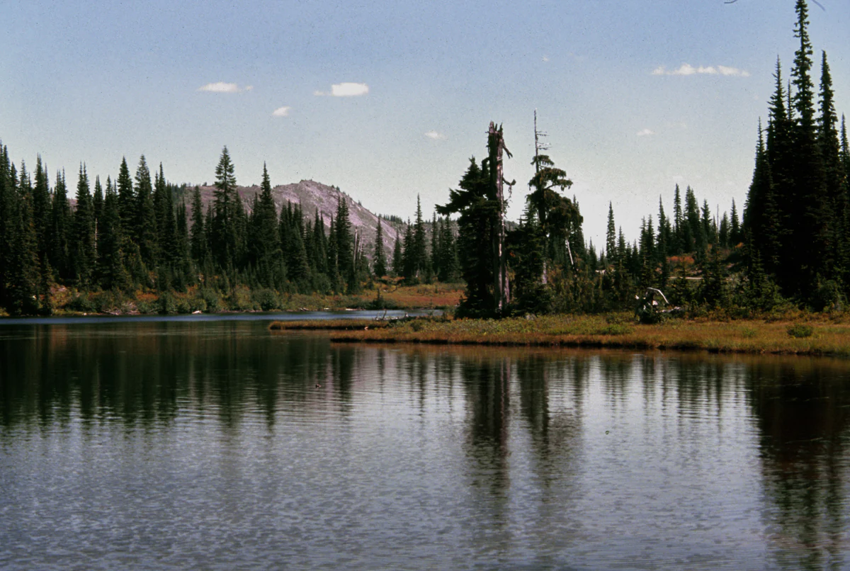
A small, calm alpine lake with reflections of surrounding pine trees and a distant low mountain in the background.
A serene alpine lake surrounded by coniferous forest in the Indian Heaven Wilderness.

Indian Heaven Wilderness ecosystems, habitats, and plant life

Indian Heaven Wilderness sits at an ecological crossroads between montane coniferous forest and high volcanic meadow environments typical of the southern Washington Cascades. The combination of relatively flat terrain, volcanic soils, abundant moisture, and numerous small wetlands supports a rich network of habitats within a compact area.

The dominant vegetation consists of dense coniferous forest, with subalpine fir and Douglas fir as the principal tree species across much of the plateau. These forests grow on the flanks of the volcanic cones and across much of the broad plateau between them, providing continuous canopy cover and habitat for forest-dwelling wildlife. The conifers also frame the many lakes and ponds that dot the wilderness, creating the classic high-elevation lakeside forest scenes that the area is known for.

Open meadows are an equally important part of the ecological mix. Some meadows represent natural openings in the volcanic landscape, while others were historically maintained or expanded through Indigenous burning practices and more recent wildfire activity. These meadows are particularly rich in berry-bearing shrubs, especially huckleberries, which turn brilliant orange in some years in late fall. The combination of fir forests, meadow openings, wetlands, and young volcanic substrate gives Indian Heaven a layered ecological character uncommon elsewhere in Washington state.

Indian Heaven Wilderness wildlife and species highlights

The mixture of old-growth forest, meadows, wetlands, and high volcanic terrain supports a healthy population of mammal species typical of the southern Cascades. Black bears are common during late summer, drawn to the ripening huckleberries that blanket the meadows and forest edges. Elk and deer also range through the wilderness during the warmer months, moving to lower elevations once heavy snow accumulates at the plateau's elevation.

A wide range of smaller forest animals, including chipmunks, inhabit the understory, and the network of lakes, ponds, and marshes provides habitat for amphibians and aquatic invertebrates adapted to cool, relatively undisturbed high-elevation waters. Birdlife is diverse as well, with numerous songbird and forest bird species nesting in the dense conifer stands around the lakes and meadows.

Indian Heaven is also known among visitors for an intense population of mosquitoes throughout the summer months. While this is a seasonal nuisance rather than an ecological feature, it reflects the combination of standing water, dense vegetation, and warm summer temperatures that make the area so attractive to wetland-associated wildlife. Together, these patterns make the wilderness a functioning, connected piece of the broader Gifford Pinchot ecosystem.

Indian Heaven Wilderness conservation status and protection priorities

Indian Heaven Wilderness was formally designated in 1984, placing the area under the heightened protection framework of the National Wilderness Preservation System. Within the Gifford Pinchot National Forest, the wilderness functions as a core landscape for the conservation of volcanic landforms, high-elevation lakes, old-growth conifer forests, and culturally significant huckleberry meadows.

The wilderness also plays a key role in safeguarding the integrity of the Indian Heaven volcanic field, one of the most significant Quaternary volcanic features in the southern Washington Cascades. By limiting development and modern infrastructure, the wilderness designation helps preserve both the visible volcanic morphology and the surrounding watersheds that feed the area's dense network of lakes and ponds.

Cultural conservation is another important dimension of the wilderness. The area continues to hold profound significance for the Yakama, Klickitat, Cascades, Wasco, Wishram, and Umatilla tribes, and the recognition of its nine-thousand-year history of Indigenous land use is now part of how it is managed. The legacy of Indigenous burning for huckleberry management, combined with the visible archaeological sites such as the Indian racetrack, adds a distinctive heritage dimension to the area's conservation profile.

Indian Heaven Wilderness cultural meaning and human context

Indian Heaven Wilderness is a culturally significant landscape with a heritage that long predates its modern wilderness designation. The plateau was known to Indigenous peoples as Sahalee Tyee, and for roughly nine thousand years it served as a traditional gathering ground where tribes from across the Columbia Plateau region came together to harvest huckleberries, fish, and hunt game. The Yakama, Klickitat, Cascades, Wasco, Wishram, and Umatilla people all maintained cultural ties to the area, and these ties continue today.

The area's cultural value is reflected in both intangible heritage and physical features. The so-called 'racetrack' near the Race Track Lakes, a circular earthen formation attributed to traditional Indigenous horse racing, is one of the area's best-known cultural landmarks. The mosaic of open berry meadows itself is also a cultural artifact, maintained over generations through traditional burning practices that encouraged huckleberry growth. As a result, the wilderness is recognized not only for its natural values but also as a living, layered cultural landscape.

Top sights and standout views in Indian Heaven Wilderness

Indian Heaven Wilderness is unmatched in the southern Cascades for its combination of small, abundant high-elevation lakes, broad volcanic vistas, and deep Indigenous heritage. Nowhere else in Washington state does the famous four-volcano panorama of Mount Adams, Mount Hood, Mount St. Helens, and Mount Rainier align so cleanly with such a dense network of accessible lakes and meadows.

The wilderness also offers rare continuity between ecology and culture. Its conifer forests, huckleberry meadows, and volcanic terrain reflect both natural processes and thousands of years of Indigenous land stewardship, including traditional burning that shaped the productive berry fields the area is still known for. Layered on top of this is the simple draw of the Pacific Crest Trail, which threads directly through the wilderness and ties Indian Heaven into the broader experience of the Cascades.

Best time to visit Indian Heaven Wilderness

Indian Heaven Wilderness is most accessible from late spring through early fall, when the higher elevations are largely free of snow and the lakes, meadows, and trails are at their most inviting. Summer offers the best conditions for hiking, lake-hopping, and long-distance travel along the Pacific Crest Trail, although visitors should be prepared for intense mosquito activity throughout the season. Morning fog and afternoon thunderstorms are common in the high country.

Late summer into early fall is particularly special. This is when huckleberries come into heavy production, attracting both bears and human visitors to the meadows, especially around the Sawtooth Berry Fields. In some years, the huckleberry foliage turns a vivid orange in late fall, adding striking seasonal color. Early autumn also brings cooler temperatures and reduced insect pressure, creating a quieter window for those interested in solitude, wildlife, or long-distance hiking along the Pacific Crest Trail. The higher elevations typically become snow-covered by late fall, limiting access for much of the winter season.

Monthly climate preview

Long term representative point measurements detailing regional temperature and precipitation patterns

Indian Heaven Wilderness Climate Normals and Annual Temperature Rhythm

Historical climatology records for Indian Heaven Wilderness outline a measured annual progression of average temperatures and daily precipitation rates based on NASA coordinate data. Examining the complete monthly normals provides deeper insight into long term environmental rhythms across the protected terrain.
Annual mean7 °C
-1 °C16 °C
Jan-1°
Feb
Mar
Apr
May
Jun12°
Jul16°
Aug16°
Sep13°
Oct
Nov
Dec-1°
Warmest month
August

16.1 °C

Coolest month
December

-1.3 °C

Wettest month
December

10.4 mm/day

Driest month
July

0.7 mm/day

Park location guide

Geography guide, regional context, and park location map for Indian Heaven Wilderness

Indian Heaven Wilderness park geography, regions, and map view in United States of America

Understand where Indian Heaven Wilderness sits in United States of America through a broader geographic reading of the surrounding landscape, nearby location context, and its mapped position within the national park landscape.

How Indian Heaven Wilderness fits into United States of America

The United States of America is a federal presidential republic and one of the world's largest countries by area and population. It consists of 50 states across a vast territory spanning multiple time zones, with its capital in Washington, D.C. and largest city in New York City. The nation has a diverse economy, influential political system, and significant cultural and military presence globally.

Wider geography shaping Indian Heaven Wilderness in United States of America

The United States occupies a vast territory in North America, bordered by Canada to the north and Mexico to the south. The 48 contiguous states stretch from the Atlantic to the Pacific Ocean, while Alaska occupies the northwestern region and Hawaii is an archipelago in the Pacific. The country encompasses diverse terrain including the Rocky Mountains, Appalachian Mountains, Great Plains, and extensive river systems.

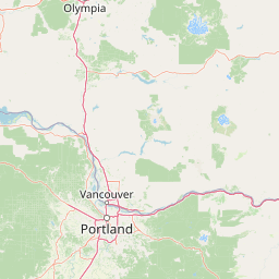
Map view of Indian Heaven Wilderness

Use this park location map to pinpoint Indian Heaven Wilderness in United States of America, understand its exact geographic position, and read its mapped placement within the surrounding landscape more clearly.

Pigeon | © OpenStreetMap contributors

Location context for Indian Heaven Wilderness

Washington
Natural feature types

Browse the Natural Landscape Atlas of Indian Heaven Wilderness

Discover the specific volcanic landforms and dense water networks that characterize the Indian Heaven Wilderness plateau. MoriAtlas provides a structured perspective on this high-country terrain to assist with geographic exploration and understanding the region's diverse natural features.
Recorded earthquake history

Browse the Historical Earthquake Catalogue for Indian Heaven Wilderness

Examine a collection of recorded earthquakes that have occurred in the vicinity of Indian Heaven Wilderness. This searchable database offers an objective view of past seismic activity mapped to the park, providing historical context for the regional landscape.

Indian Heaven Wilderness Earthquake History

Catalogued events

1,216 events

Strongest magnitude

Magnitude 5.7

Most recent event

Feb 9, 2021

This history includes earthquakes recorded inside the park or within 50 km of its borders

Visualizing high-plateau terrain, alpine lakes, and protected Cascade environments

Indian Heaven Wilderness Photos and Volcanic Landscape Scenery

Examine detailed imagery of Indian Heaven Wilderness to understand its distinctive volcanic plateau and dense network of high-country lakes. Visual records reveal the unique forest habitats and expansive mountain vistas that define this protected southern Washington landscape.

A wide, golden-brown meadow bordered by a thick, dark green forest of coniferous trees under a clear, light sky.

A jagged volcanic peak rises above a steep mountainside covered in a large boulder field and scattered evergreen trees under a clear blue sky.

A small, calm alpine lake with reflections of surrounding pine trees and a distant low mountain in the background.

Park atlas

Compare surrounding volcanic landscapes and connected regional wilderness areas.

Parks Near Indian Heaven Wilderness and Other Protected Areas in the Region

Visitors exploring Indian Heaven Wilderness can browse nearby national parks and protected areas across the southern Cascades. Comparing adjacent terrain reveals broader volcanic formations, high-country forests, and connected regional geography.
A horizontal watercolor illustration featuring a waterfall on the left, a range of rolling mountains in the background, and clusters of trees in the midground, rendered in soft, blended colors.
Protected landscapeWashington
Park boundaries overlap#1 closest

North

Gifford Pinchot National Forest: Geographic Overview of Washington's Volcanic Cascade Protected Lands

Mapping volcanic peaks, deep river canyons, and old-growth wilderness corridors

Gifford Pinchot National Forest represents a major protected expanse in the Washington Cascades, characterized by a complex volcanic topography that includes active craters, cinder cones, and rugged lava fields. This atlas entry details the forest's primary geographic features, from the high-elevation alpine terrain of the Goat Rocks to the river-carved valleys of the Lewis and Cowlitz systems, providing essential context on this integral Pacific Northwest protected landscape.

Area
5,347.95 km²
Established
1908
Visitors
1.8M annual
Relief
Mountain
Watercolor painting of a snow covered volcanic mountain peak in the distance behind a foreground of green meadow, wildflowers, and a winding river.
Wildlife reserveWashington
13 km away#2 closest

Northeast

Mount Adams Wilderness: Volcanic Terrain and Protected Landscapes in Washington State

Mapping the high altitude meadows and volcanic ridges

Spanning roughly 47,700 acres, Mount Adams Wilderness presents a unique geological mosaic of cinder cones, lava flows, and permanent snowfields. The area offers a profound look at Cascade Range geography, from its western forested valleys to its open alpine basins, serving as a critical protected landscape for understanding volcanic, glacial, and fluvial processes in the Pacific Northwest.

Area
193.07 km²
Established
1964
IUCN
Ib
Relief
Mountain
A watercolor painting showing a snowy mountain peak in the background rising above rolling green hills and pine forests in the foreground.
Protected landscapeOregon
26 km away#3 closest

South

Mount Hood National Forest: Atlas of Protected Landscapes and Volcanic Geography

Exploring the Cascade Range terrain and wilderness boundaries in Oregon.

Mount Hood National Forest encompasses a vast, rugged expanse of the Oregon Cascades, anchored by the iconic, glacier-clad Mount Hood. This protected landscape contains extensive old-growth forests, high-alpine lakes, and deep river canyons. Discover the geographic extent of these wilderness areas and mountain terrain within the MoriAtlas database of protected lands.

Area
4,318.17 km²
Established
1908
Visitors
4.4M annual
Relief
Mountain
Wildlife reserveOregon
27 km away#4 closest

South

Mark O. Hatfield Wilderness: An Atlas of Basalt Canyons and Cascade Mountain Terrain

Protected rugged wilderness located in Oregon

Spanning from the Columbia River Gorge to the slopes of Mount Hood, the Mark O. Hatfield Wilderness preserves an array of forest stands, hanging meadows, and steep ridgelines. The area serves as a critical geographic hub within the Cascade Range, offering detailed insight into the volcanic geology and drainage systems that shape this iconic portion of Oregon.

Area
266.37 km²
Established
1984
IUCN
Ib
Relief
Mountain
Protected landscapeOregon
50 km away#5 closest

South

Mount Hood National Recreation Area: Oregon Protected Landscape and Regional Geography

A three-unit recreational forest landscape in the Cascade Range.

Spanning over 34,000 acres, this protected landscape frames the lower volcanic slopes and forested drainages around Mount Hood. The area integrates river corridors, wilderness boundaries, and subalpine terrain, offering a clear view of the complex topography that defines the Cascade Range in northern Oregon.

Area
139.8 km²
Established
2009
Relief
Mountain
Climate
Temperate
A watercolor painting of a mountain landscape with soft-colored rolling hills, a green forest line, and foreground vegetation on a white background.
Protected landscapeWashington
53 km away#6 closest

North

Okanogan, Wenatchee National Forest: A Comprehensive Look at Washington's Protected Mountain Landscapes

Mapping ecological gradients and wilderness boundaries across the eastern Cascade Range

Spanning from the moist coniferous forests of the western Cascades to the arid plateaus of the Okanogan, this massive national forest protects an unmatched diversity of terrain. Explore the intricate geography of river-carved valleys, glacial cirques, and remote wilderness areas that characterize this critical environmental corridor in the Pacific Northwest.

Area
6,066.33 km²
Established
1911
Visitors
397K annual
Relief
Mountain
A watercolor painting showing a wide, panoramic view of a mountain range in the background, rolling green hills in the midground, and a small cluster of evergreen trees in the foreground against a white background.
Wildlife reserveOregon
53 km away#7 closest

South

Mount Hood Wilderness: Atlas of Volcanic Peaks and Glacial Geography in Oregon

High-altitude protected landscapes and forest ecosystems

This protected area captures the dramatic character of the Cascade Range through its signature volcanic terrain, ancient forests, and high-alpine ridges. Covering a vast vertical range, the wilderness offers a study in geologic forces, featuring active glaciers, deep basaltic canyons, and meadows that define the mountain's northern and western slopes.

Area
262 km²
Established
1964
IUCN
Ib
Visitors
10K annual
National parkWashington
71 km away#8 closest

North

Mount Rainier National Park: A National Park in Washington with Distinct Mapped Boundaries

Explore its protected landscape and regional geography.

Mount Rainier National Park represents a core protected area within Washington State, offering rich opportunities for geographic discovery through its mapped boundaries and natural terrain. As a designated national park, it contributes significantly to the atlas of United States protected lands. This destination allows for detailed exploration of its landscape context, making it an essential point of reference for understanding regional geography and conservation areas.

Area
956.6 km²
Established
1899
IUCN
II
Visitors
1.6M annual

Common questions about visiting, size, designation, and location context for Indian Heaven Wilderness

Indian Heaven Wilderness FAQs for park facts, access, geography, and protected area context

Find quick answers about Indian Heaven Wilderness, including protected-area facts, park geography, trail and visitor context, and how the park fits into its surrounding country and regional landscape.
MoriAtlas Explorer

Continue Your Protected Areas Search Across the Global Atlas

Deepen your exploration by continuing the structured search for national parks and protected areas worldwide. Utilize the comprehensive filtering capabilities to compare different conservation landscapes and refine your understanding of global park geography. Discover more about the distribution and characteristics of protected natural areas.

Global natural geography