Volcanoes
Lemei Rock
1,805.9 m

Structured data on mountain elevation, volcanic features, and hydrological patterns.
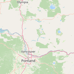
This geographic profile tracks the spatial attributes of Indian Heaven Wilderness in Washington, including an area of 84.1 square kilometers and a maximum recorded elevation of 1806 meters. The dataset details the distribution of volcanic peaks, alpine lakes, and drainage systems within the protected boundaries to support comprehensive spatial analysis.
Related tags
A volcanic plateau of lakes, meadows, and old-growth forests in the southern Washington Cascades.
Indian Heaven Wilderness is a protected federal wilderness area located within the Gifford Pinchot National Forest in southwestern Washington state. The designation covers a broad, forested volcanic plateau studded with more than 150 small lakes, ponds, and marshes, and scattered with meadows that weave between numerous volcanic peaks. The landscape is a defining expression of the Indian Heaven volcanic field, a Quaternary basalt field that forms part of the southern Washington Cascades. The area has long held deep cultural meaning for Native peoples of the Pacific Northwest. The plateau was originally known as 'Sahalee Tyee' and has served as a gathering place for the Yakama, Klickitat, Cascades, Wasco, Wishram, and Umatilla tribes for approximately nine thousand years. Indigenous use of the land for berry picking, fishing, and hunting continues to shape the area's identity today. Now formally protected, the wilderness combines dramatic Cascade scenery, wildlife habitat, cultural heritage, and accessible hiking. The Pacific Crest National Scenic Trail passes through its heart, and the broad volcanic viewpoints offer rare sights of four major Cascade volcanoes in a single panorama. This combination of natural and cultural richness makes Indian Heaven a distinctive destination within the U.S. National Wilderness Preservation System.
National and regional administrative memberships for protected area mapping
Indian Heaven Wilderness maps an 84.1 km² extent
Mountain relief statistics and recorded peaks, lakes, and streams
Volcanoes
1,805.9 m
Lakes
1,299 m
Lakes
1,284 m
Streams
Streams
Streams
Temperate mountain relief, major water systems, and seasonal volcanic terrain
Mountains · Forest · Lakes · Volcano
Compare surrounding volcanic landscapes and connected regional wilderness areas.

North

Mapping volcanic peaks, deep river canyons, and old-growth wilderness corridors
Gifford Pinchot National Forest represents a major protected expanse in the Washington Cascades, characterized by a complex volcanic topography that includes active craters, cinder cones, and rugged lava fields. This atlas entry details the forest's primary geographic features, from the high-elevation alpine terrain of the Goat Rocks to the river-carved valleys of the Lewis and Cowlitz systems, providing essential context on this integral Pacific Northwest protected landscape.
Northeast
Mapping the high altitude meadows and volcanic ridges
Spanning roughly 47,700 acres, Mount Adams Wilderness presents a unique geological mosaic of cinder cones, lava flows, and permanent snowfields. The area offers a profound look at Cascade Range geography, from its western forested valleys to its open alpine basins, serving as a critical protected landscape for understanding volcanic, glacial, and fluvial processes in the Pacific Northwest.

South
Exploring the Cascade Range terrain and wilderness boundaries in Oregon.
Mount Hood National Forest encompasses a vast, rugged expanse of the Oregon Cascades, anchored by the iconic, glacier-clad Mount Hood. This protected landscape contains extensive old-growth forests, high-alpine lakes, and deep river canyons. Discover the geographic extent of these wilderness areas and mountain terrain within the MoriAtlas database of protected lands.
South
Protected rugged wilderness located in Oregon
Spanning from the Columbia River Gorge to the slopes of Mount Hood, the Mark O. Hatfield Wilderness preserves an array of forest stands, hanging meadows, and steep ridgelines. The area serves as a critical geographic hub within the Cascade Range, offering detailed insight into the volcanic geology and drainage systems that shape this iconic portion of Oregon.
South
A three-unit recreational forest landscape in the Cascade Range.
Spanning over 34,000 acres, this protected landscape frames the lower volcanic slopes and forested drainages around Mount Hood. The area integrates river corridors, wilderness boundaries, and subalpine terrain, offering a clear view of the complex topography that defines the Cascade Range in northern Oregon.

North
Mapping ecological gradients and wilderness boundaries across the eastern Cascade Range
Spanning from the moist coniferous forests of the western Cascades to the arid plateaus of the Okanogan, this massive national forest protects an unmatched diversity of terrain. Explore the intricate geography of river-carved valleys, glacial cirques, and remote wilderness areas that characterize this critical environmental corridor in the Pacific Northwest.
South
High-altitude protected landscapes and forest ecosystems
This protected area captures the dramatic character of the Cascade Range through its signature volcanic terrain, ancient forests, and high-alpine ridges. Covering a vast vertical range, the wilderness offers a study in geologic forces, featuring active glaciers, deep basaltic canyons, and meadows that define the mountain's northern and western slopes.
North
Explore its protected landscape and regional geography.
Mount Rainier National Park represents a core protected area within Washington State, offering rich opportunities for geographic discovery through its mapped boundaries and natural terrain. As a designated national park, it contributes significantly to the atlas of United States protected lands. This destination allows for detailed exploration of its landscape context, making it an essential point of reference for understanding regional geography and conservation areas.
Examine the unique geological features and vast lake networks within the Indian Heaven Wilderness through our detailed map data. Gain insights into the Cascade plateau terrain and the historical significance of this protected landscape as cataloged by MoriAtlas.