
Mori Atlas logo
State or regional parkInkaneep Provincial Park

A critical node for habitat connectivity and native plant communities within the arid south Okanagan valley

Inkaneep Provincial Park: Exploring Protected Riparian Ecosystems and Riverine Geography in British Columbia

Inkaneep Provincial Park serves as a compact but essential protected area along the Okanagan River in southern British Columbia. This geography focuses on preserving rare riparian habitats, including old-growth black cottonwood stands and antelope brush communities, which contrast sharply with the surrounding arid valley terrain. The park plays a significant role in supporting regional ecological integrity, salmon habitat, and the long-term health of diverse bird populations in an ecologically sensitive zone.

riparian habitatOkanagan Riversouth OkanaganBritish Columbiaprovincial parkbirdwatching
An illustration of a river winding through a lush green valley with forested riverbanks and mountains in the distance, rendered in a clean flat design style.

Inkaneep Provincial Park

State or regional park

Park overview

Structured park overview, official facts, and landscape profile for Inkaneep Provincial Park

Inkaneep Provincial Park park facts, protected area profile, and essential visitor context

Review the core facts for Inkaneep Provincial Park, including designation, size, terrain, visitor scale, habitats, and operating context in one park-focused overview.

About Inkaneep Provincial Park

Inkaneep Provincial Park is a compact but ecologically significant protected area on the Okanagan River in southern British Columbia. Located near the town of Oliver and immediately south of Okanagan Falls, the park sits within the dry, rolling landscape of the south Okanagan, a region characterized by semi-arid conditions, sagebrush-steppe vegetation, and a river system that supports a remarkably high level of biodiversity given the surrounding climate.

The park's overarching purpose is the protection of riparian habitat along the Okanagan River. Riparian zones, the vegetated margins of rivers and streams, are disproportionately important in arid regions because they concentrate moisture, structural complexity, and food resources in an otherwise dry landscape. Inkaneep's riverfront forests and shrub thickets provide nesting sites, cover, and foraging habitat for birds and mammals, while also shading the river, stabilizing banks, and contributing to the conditions that salmon and other aquatic species rely on.

The park is divided into two distinct areas. One parcel straddles a section of the Okanagan Flood Control right of way, extending the protected footprint along a roughly 750-metre stretch of the river. The other area lies on the east side of Tuc-El-Nuit Road and directly adjoins the Osoyoos Indian Reserve No. 1. Together, these two parcels form a small but strategically placed network of habitat along one of the most ecologically important rivers in British Columbia's interior.

Inkaneep is appreciated for its quiet, observational character rather than for developed visitor infrastructure. Naturalists, bird-watchers, and others interested in the natural heritage of the Okanagan visit the park to experience a relatively intact example of the valley's riparian ecosystems. Visitors should be aware that poison ivy is abundant in the area and exercise caution when walking through the vegetation.

Quick facts and research context for Inkaneep Provincial Park

Inkaneep Provincial Park is a small British Columbia provincial park located along the Okanagan River near Oliver and Okanagan Falls, in the south Okanagan region of Canada. Established in 1956 and classified as an IUCN Category II protected area, it covers roughly 20 hectares split between two separate parcels.

The park was created and continues to be managed primarily to protect riparian habitat along the Okanagan River. It contains rare ecosystems and species of conservation concern, including old-growth black cottonwood stands, antelope brush, and habitat for Lewis's woodpecker, yellow-breasted chat, and sockeye salmon. The eastern section of the park abuts the Osoyoos Indian Reserve No. 1, reflecting the broader cultural importance of the river corridor.

Protection and recognition

Explore terrestrial protection metrics and official designation data.

Inkaneep Provincial Park Protection Status and Conservation Records

Inkaneep Provincial Park maintains a documented terrestrial protection scope within the regional conservation network. Structured conservation records outline established protective parameters and international recognition frameworks for the protected area.

Protection details

Protection scope
Terrestrial
Transboundary protection
No
Park context

Deeper park guide and search-rich context for Inkaneep Provincial Park

Inkaneep Provincial Park history, landscape, wildlife, and travel context

Explore Inkaneep Provincial Park through its history, landscape character, ecosystems, wildlife, conservation priorities, cultural context, and seasonal travel timing in a structured park guide built for atlas discovery and search intent.

Why Inkaneep Provincial Park stands out

Inkaneep Provincial Park is best known for its role in protecting a narrow but ecologically rich stretch of Okanagan River riparian habitat in one of Canada's most arid valleys. The park safeguards plant communities and wildlife that depend on the river corridor, including old-growth black cottonwood, antelope brush, and rare bird species such as Lewis's woodpecker and the yellow-breasted chat. It is also recognized for its connection to the Okanagan River salmon run, with First Nations identifying the park's riparian zone as an important contributor to the long-term viability of sockeye salmon in the system. In a region where natural vegetation has been extensively altered by agriculture and development, Inkaneep stands out as a concentrated pocket of intact riverine habitat.
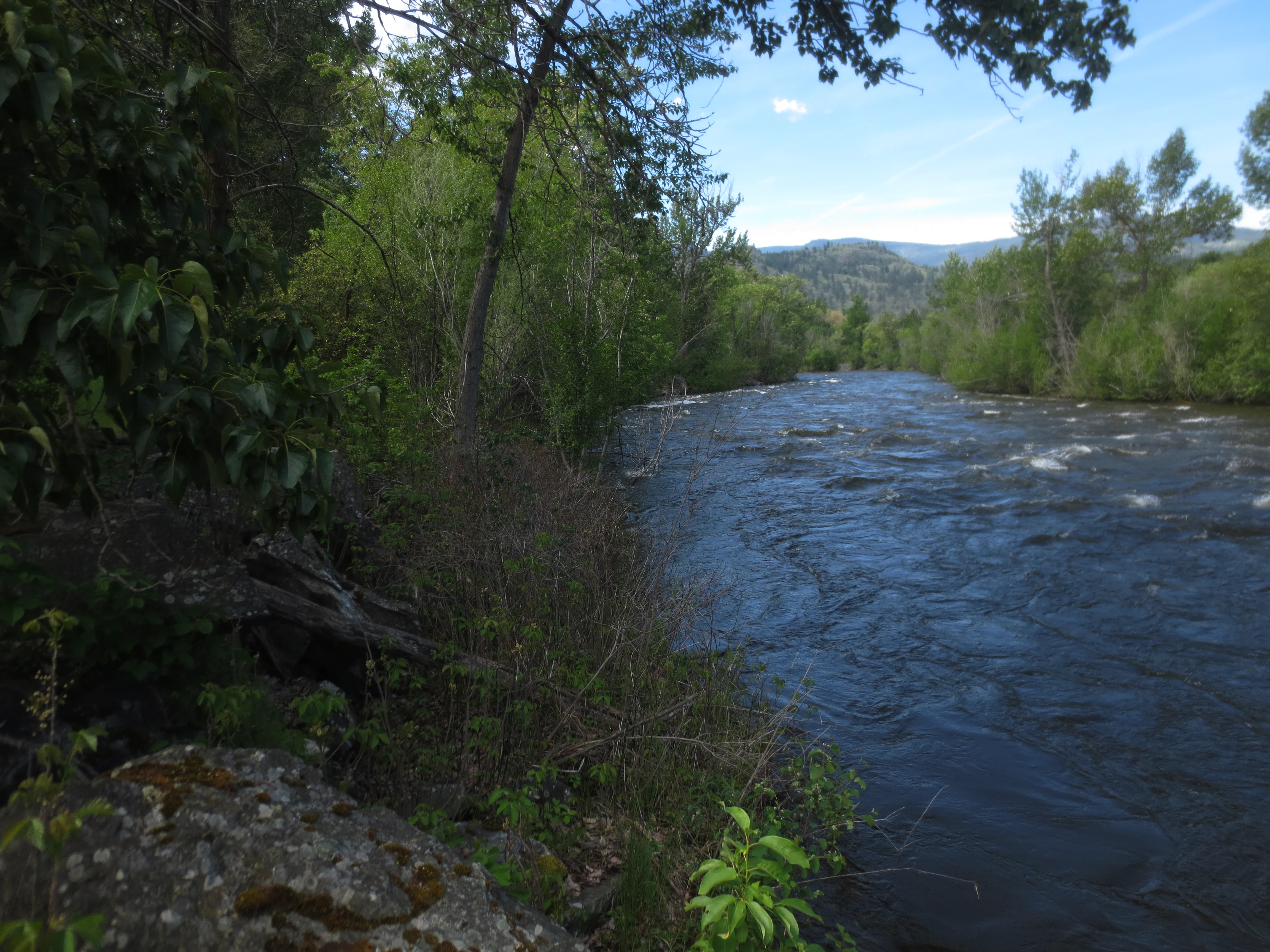
A view of the fast-flowing, dark blue Okanagan River bordered by lush green deciduous trees and riparian vegetation.
The Okanagan River flowing through Inkaneep Provincial Park, observed during high water levels.

Inkaneep Provincial Park history and protected-area timeline

Inkaneep Provincial Park was formally established on 16 March 1956 as a British Columbia provincial park. From its inception, the park has been oriented toward the protection of the riparian environment along the Okanagan River, reflecting the recognition that this narrow band of habitat supports ecological values far greater than its modest area might suggest.

Over the decades, the park's significance has only grown as surrounding land in the south Okanagan has been converted to agriculture, vineyards, and residential development. As natural riparian vegetation has become increasingly rare in the region, Inkaneep's protected cottonwood stands, shrub thickets, and river frontage have taken on added conservation weight. First Nations in the area have also identified the river and riparian area within and adjacent to the park as an important contributor to the long-term viability of the Okanagan River salmon run, linking the park's history to ongoing Indigenous stewardship of the watershed.

Today the park continues to be managed under British Columbia's provincial park system as an IUCN Category II protected area, with its primary mandate remaining the conservation of the Okanagan River's riparian values.

Inkaneep Provincial Park landscape and geographic character

Inkaneep Provincial Park occupies a narrow corridor of land along the Okanagan River in the south Okanagan, a region defined by its warm, dry climate and its contrast between arid uplands and lush riverfront vegetation. The river itself is the centerpiece of the park's landscape, a slow-moving watercourse that, in spring, can swell notably with snowmelt from the surrounding mountains, as occurred in 2017.

The terrain within the park is relatively low and flat, shaped by the river's floodplain and the flood control infrastructure that borders it. The most visually distinctive features are the tall black cottonwood trees that line the riverbanks and the dense understory of shrubs and grasses that fill the spaces beneath them. These riparian plant communities stand in sharp contrast to the dry sagebrush-steppe that surrounds the valley, giving the park a green, sheltered character unusual for the region.

The park's two separate parcels reflect how the landscape has been shaped by both natural processes and human land-use decisions. One parcel threads through the flood control right of way, following the river's path, while the other lies on the opposite side of Tuc-El-Nuit Road, adjacent to the Osoyoos Indian Reserve No. 1. Together they illustrate the fragmented but interconnected nature of remaining natural habitat along the lower Okanagan River.

Inkaneep Provincial Park ecosystems, habitats, and plant life

The natural environment of Inkaneep Provincial Park is defined by its riparian ecosystems, which support a concentration of plant and animal life well beyond what the park's small size might suggest. Within the dry south Okanagan, riverside habitats are biodiversity hotspots, providing cool, moist conditions and structural diversity that the surrounding landscape cannot offer.

A key feature of the park is its old-growth black cottonwood forest, a tree community that has become increasingly rare in British Columbia as riverside lands have been cleared for agriculture and development. Beneath and around these cottonwoods grows a distinctive shrub layer that includes antelope brush, a species associated with one of the four most endangered ecosystems in Canada. Three-awn grass contributes to the understory as well, adding to the botanical diversity of the park's plant communities.

These habitats together support a rich animal community adapted to the interface between water, woodland, and arid upland. The park's vegetation patterns also matter for the river itself, shading banks, filtering runoff, and providing the structural elements that aquatic species rely on. The result is a small but ecologically dense reserve that captures much of what makes the south Okanagan's river corridors so important.

Inkaneep Provincial Park wildlife and species highlights

Inkaneep Provincial Park is recognized primarily as a birding destination, reflecting the importance of its riparian habitat to a wide variety of bird species. Among the most notable species associated with the park is Lewis's woodpecker, a charismatic bird of open woodlands that depends on standing trees with suitable nesting cavities. The park's mature cottonwoods provide exactly this kind of structure, making the area meaningful for the species' continued presence in the region.

The yellow-breasted chat, a rare and localized songbird in Canada, has also been documented in the park. Its presence here is part of what gives Inkaneep its conservation profile, as the species depends on dense riparian shrub thickets that have become scarce across much of its range. Together, these and other bird species draw naturalists and bird-watchers to the park, which is widely regarded as a rewarding stop in the south Okanagan.

Beyond birds, the park's waters and banks contribute to the life cycle of sockeye salmon in the Okanagan River system. First Nations have identified the riparian area of the park as an important contributor to the long-term viability of this salmon run. The combination of birdlife, salmon habitat, and the structural complexity of the riparian zone gives Inkaneep a wildlife profile that feels outsized compared to the park's footprint.

Inkaneep Provincial Park conservation status and protection priorities

Inkaneep Provincial Park holds meaningful conservation value within one of Canada's most threatened ecological regions. Although the park covers only about 20 hectares, the habitats it protects, particularly its old-growth black cottonwood stands and antelope brush communities, are part of ecosystems ranked among the four most endangered in Canada. In a region where natural vegetation has been extensively altered by human activity, even small protected remnants become disproportionately important.

The park's riparian zone is central to its conservation role, functioning as a refuge for species that depend on riverside conditions in an otherwise arid landscape. By protecting a stretch of the Okanagan River's banks, Inkaneep helps maintain habitat connectivity along a watercourse that supports salmon, migratory birds, and a wide range of other wildlife. The park's contribution to sockeye salmon habitat is a particularly significant element of its conservation profile.

Recognition of these values underpins the park's ongoing management direction. Its primary purpose remains the protection of riparian habitat, and its IUCN Category II designation reflects the high level of protection afforded to the area. In the broader context of south Okanagan conservation, Inkaneep represents one of the small but critical nodes in the network of natural areas that continue to sustain the region's ecological character.

Inkaneep Provincial Park cultural meaning and human context

The lands and waters around Inkaneep Provincial Park carry deep significance for Indigenous peoples of the Okanagan. The eastern portion of the park abuts the Osoyoos Indian Reserve No. 1, placing the protected area in direct connection with the traditional homeland of the Osoyoos Indian Band. This adjacency is not incidental; it reflects the long-standing relationship between the Okanagan River and the communities that have lived along it for generations.

First Nations have identified the Okanagan River and the riparian area within and adjacent to the park as very important contributors to the long-term viability of the Okanagan River salmon run. This recognition links the park's ecological role to broader Indigenous stewardship of the watershed and to cultural relationships with salmon that extend well beyond any single administrative boundary. The park's conservation value is therefore inseparable from the cultural landscape in which it sits.

Top sights and standout views in Inkaneep Provincial Park

Inkaneep Provincial Park stands out for packing a remarkable range of ecological values into a compact riverside footprint. Its old-growth black cottonwood stands, antelope brush communities, and dense riparian shrub thickets represent vegetation types that have been greatly reduced elsewhere in the south Okanagan and that are associated with some of Canada's most endangered ecosystems.

The park is also a well-regarded birding site in the region, with species such as Lewis's woodpecker and the yellow-breasted chat drawing naturalists to the area. Its contribution to sockeye salmon habitat and its location alongside the Osoyoos Indian Reserve No. 1 give it both ecological and cultural significance, making it a small but meaningful node in the network of natural and culturally significant places along the lower Okanagan River.

Best time to visit Inkaneep Provincial Park

Inkaneep Provincial Park is most rewarding to visit during the milder months of the year, when the Okanagan region is accessible and its bird and plant life are most active. Spring brings the snowmelt that swells the Okanagan River and renews seasonal growth in the riparian vegetation, while late spring and early summer tend to offer good conditions for observing nesting birds and the full development of the park's shrub layers.

Late spring through early fall generally provides comfortable conditions for walking the park and observing its birdlife, though visitors should be prepared for warm to hot temperatures typical of the south Okanagan. Because the park's purpose is ecological rather than recreational, visits are best approached as quiet, observational experiences rather than as destination outings, and timing visits to coincide with milder parts of the day can enhance both comfort and wildlife viewing opportunities.
Monthly climate preview

Long-term temperature ranges and precipitation patterns measured at a representative park coordinate

Inkaneep Provincial Park Climate Normals and Monthly Weather Statistics

Representative coordinate records show wide annual temperature swings alongside steady precipitation averages across twelve distinct observation periods. Detailed monthly comparisons reveal the full statistical range for thermal conditions and baseline moisture levels.
Annual mean5 °C
-7 °C19 °C
Jan-7°
Feb-5°
Mar
Apr
May11°
Jun14°
Jul19°
Aug18°
Sep13°
Oct
Nov-2°
Dec-7°
Warmest month
July

18.7 °C

Coolest month
January

-7 °C

Wettest month
June

1.6 mm/day

Driest month
August

0.6 mm/day

Park location guide

Geography guide, regional context, and park location map for Inkaneep Provincial Park

Inkaneep Provincial Park park geography, regions, and map view in Canada

Understand where Inkaneep Provincial Park sits in Canada through a broader geographic reading of the surrounding landscape, nearby location context, and its mapped position within the national park landscape.

How Inkaneep Provincial Park fits into Canada

Canada is a federal parliamentary constitutional monarchy spanning North America from the Atlantic to the Pacific and Arctic Oceans. With a population of over 41 million, it is officially bilingual in English and French at the federal level. The country gained independence from the United Kingdom through a gradual process culminating in 1982.

Wider geography shaping Inkaneep Provincial Park in Canada

Canada occupies the northern portion of North America, sharing its longest international border with the United States. The country extends from the Atlantic Ocean to the Pacific Ocean and northward into the Arctic Ocean, giving it the longest coastline of any nation.

Map view of Inkaneep Provincial Park

Use this park location map to pinpoint Inkaneep Provincial Park in Canada, understand its exact geographic position, and read its mapped placement within the surrounding landscape more clearly.

Pigeon | © OpenStreetMap contributors

Location context for Inkaneep Provincial Park

British Columbia

Explore riparian habitats, cottonwood stands, and arid valley scenery across the protected area.

Inkaneep Provincial Park Photos and Landscapes: Visualizing the Protected River Valley

Visual documentation reveals the distinct terrain, old-growth cottonwoods, and lush riverfront vegetation that define Inkaneep Provincial Park. Photographic records provide a clear perspective on the rare riparian habitats surviving within this arid southern Okanagan valley corridor.

A view of the fast-flowing, dark blue Okanagan River bordered by lush green deciduous trees and riparian vegetation.

Park atlas

Compare adjacent river reserves and regional conservation landscapes in British Columbia

Explore Protected Areas Near Inkaneep Provincial Park and Surrounding Valleys

Visitors exploring Inkaneep Provincial Park can discover other protected areas sharing similar arid valley geography and river corridor traits. Comparing nearby conservation lands reveals broader ecological connectivity across the southern Okanagan region.
Watercolor painting of a calm river winding through a forested landscape with soft hills in the background at sunset.
State or regional parkBritish Columbia
About 43 km away#1 closest

East

Kettle River Recreation Area: Protected Dry Belt Landscapes and River Geography in British Columbia

Mapping riparian corridors and southern interior ecological zones

Located within the Kootenay Boundary, Kettle River Recreation Area protects a rare intersection of dry ponderosa pine-bunchgrass communities and old growth cottonwood stands. The park creates a distinct geographic enclosure shaped by a sharp S-bend in the river, providing a significant reference point for dry-belt interior ecosystems within the broader British Columbia provincial park network.

Area
1.79 km²
Established
1972
IUCN
II
Relief
Upland
A watercolor painting of a mountain landscape with soft-colored rolling hills, a green forest line, and foreground vegetation on a white background.
Protected landscapeWashington
About 43 km away#2 closest

Southwest

Okanogan, Wenatchee National Forest: A Comprehensive Look at Washington's Protected Mountain Landscapes

Mapping ecological gradients and wilderness boundaries across the eastern Cascade Range

Spanning from the moist coniferous forests of the western Cascades to the arid plateaus of the Okanogan, this massive national forest protects an unmatched diversity of terrain. Explore the intricate geography of river-carved valleys, glacial cirques, and remote wilderness areas that characterize this critical environmental corridor in the Pacific Northwest.

Area
6,066.33 km²
Established
1911
Visitors
397K annual
Relief
Mountain
State or regional parkBritish Columbia
About 69 km away#3 closest

East

Jewel Lake Provincial Park: Geography and Protected Landscapes in British Columbia

A ridge-flanked valley lake with historic mining heritage

Jewel Lake Provincial Park preserves a narrow, forty-nine hectare freshwater ecosystem in the Boundary region of British Columbia. The area provides a detailed look at ridge-flanked mountain terrain and the historical mining landscape that defines this section of the West Kootenay-Boundary corridor.

Area
0.49 km²
Established
1981
IUCN
II
Climate
Temperate
A horizontal watercolor painting depicting a soft-focus mountain landscape with rolling green meadows, patches of coniferous forest, and distant pale mountains under a white sky.
State or regional parkBritish Columbia
About 78 km away#4 closest

West

E. C. Manning Provincial Park: A Comprehensive Geographic Atlas and Protected Area Overview

Mountainous terrain and ecological transitions in southern British Columbia

Spanning the cross section of the Canadian Cascades, E. C. Manning Provincial Park preserves a high-elevation landscape of wildflowers, glacial valleys, and mountain ridges. The protected area links temperate coastal rainforests with the arid interior, providing a study in regional hydrology and subalpine ecology defined by the Hozameen Range and the northern reaches of the Pacific Crest Trail.

Area
836.71 km²
Established
1941
IUCN
II
Visitors
1.1M annual
Protected landscapeBritish Columbia
About 99 km away#5 closest

Northeast

Graystokes Provincial Park: Geographic Overview of British Columbia Protected Wilderness

Exploring the Okanagan Highland plateau and alpine wetland systems

Graystokes Provincial Park functions as a key protected landscape in the British Columbia interior. This backcountry expanse is defined by its rolling plateau terrain, encompassing alpine wetlands, meadows, and riparian habitats set against a backdrop of Engelmann spruce and subalpine fir forests.

Area
119.58 km²
Established
2001
Relief
Highland
Climate
Alpine
Wildlife reserveWashington
About 99 km away#6 closest

Southwest

Lake Chelan-Sawtooth Wilderness: Geographic Atlas and Protected Landscape Overview

North Cascades Wilderness in Washington State

Located in the north-central Cascade Range of Washington, this protected wilderness area contains 63 glacial lakes and extensive alpine terrain. The region offers a complex landscape of cirques, subalpine meadows, and forested valleys that connect directly to the larger North Cascades protected network. Use this atlas to examine its mountainous geography and defined conservation boundaries.

Area
619.4 km²
Established
1984
IUCN
Ib
Relief
Mountain
A watercolor painting showing a soft landscape with rolling hills, a winding stream or lake, and grassy vegetation.
State or regional parkBritish Columbia
About 107 km away#7 closest

Northwest

Kentucky Alleyne Provincial Park: Glacial Landscapes and Interior Protected Areas

Mapping kettle lake geography in the British Columbia interior

Kentucky Alleyne Provincial Park preserves a compact, richly varied landscape of kettle lakes, eskers, and dry interior forest. Located in the Nicola region of British Columbia, this protected area offers a clear look at glacial landforms and sun-warmed Ponderosa pine woodlands, standing as a distinct geographic landmark within the Canadian interior range country.

Area
1.9 km²
Established
1981
IUCN
II
Relief
Upland
State or regional parkBritish Columbia
About 108 km away#8 closest

North

Kalamalka Lake Provincial Park and Protected Area: Mapped Geography and Regional Context

A conservation landscape of the North Okanagan valley

Kalamalka Lake Provincial Park and Protected Area preserves 978 hectares of essential grassland and lakeshore habitats in British Columbia. The area features a complex mosaic of open meadows and mixed forest stands, offering a detailed perspective on the ecological transitions found within the Okanagan Valley. Its geography is defined by the shimmering turquoise waters of Kalamalka Lake, reflecting the unique interplay between seasonal mineral shifts and the surrounding arid terrain.

Area
9.78 km²
Established
1975
IUCN
II
Relief
Upland

Common questions about visiting, size, designation, and location context for Inkaneep Provincial Park

Inkaneep Provincial Park FAQs for park facts, access, geography, and protected area context

Find quick answers about Inkaneep Provincial Park, including protected-area facts, park geography, trail and visitor context, and how the park fits into its surrounding country and regional landscape.
MoriAtlas Explorer

Continue Your Protected Areas Search Across the Global Atlas

Deepen your exploration by continuing the structured search for national parks and protected areas worldwide. Utilize the comprehensive filtering capabilities to compare different conservation landscapes and refine your understanding of global park geography. Discover more about the distribution and characteristics of protected natural areas.

Global natural geography