Mori Atlas logo
Wildlife reserveIshi Wilderness

Exploring the rugged river canyons, volcanic terrain, and protected cultural landscapes of the northern California foothills.

Ishi Wilderness Wildlife Reserve: A Mapped Atlas of the Southern Cascade Foothills in California

Ishi Wilderness preserves a singular ecological and geological zone within the southernmost Cascade Range foothills of northern California. This federal wildlife reserve encompasses a complex network of east-west ridgelines and deeply incised canyons carved by Mill Creek and Deer Creek. The protected terrain features sculptural pillar lava, basalt outcroppings, and natural caves, providing a rare look at an ancient volcanic landscape that remains largely unchanged by modern development.

wilderness areaCascade foothillsTehama CountyLassen National Forestchaparralpine and oak woodland

Ishi Wilderness

Wildlife reserve

Park overview

Structured park overview, official facts, and landscape profile for Ishi Wilderness

Ishi Wilderness park facts, protected area profile, and essential visitor context

Review the core facts for Ishi Wilderness, including designation, size, terrain, visitor scale, habitats, and operating context in one park-focused overview.

About Ishi Wilderness

Ishi Wilderness is a 41,339-acre federally designated wilderness in the Shasta Cascade foothills of northern California, located in Tehama County about 20 miles east of Red Bluff. Situated on the Lassen National Forest and managed primarily by the U.S. Forest Service, with a small Bureau of Land Management parcel included, the area was added to the National Wilderness Preservation System through the California Wilderness Act of 1984.

The terrain exemplifies the transition zone between the higher Cascade peaks and the Central Valley lowlands. East-west running ridges frame deep canyons cut by Deer Creek and Mill Creek, the two principal drainages that ultimately flow into the Sacramento River. The highest ridges reach approximately 4,000 feet in elevation. Across this framework the landscape is shaped by volcanic and erosional processes: basalt outcroppings, natural caves, and unusual pillar lava formations give the area a rugged, weathered character that distinguishes it from neighboring forestland.

Ecologically, the wilderness captures the layered vegetation typical of the Sierra/Cascade foothills. Sun-exposed south slopes are dominated by chaparral, while north-facing slopes support pine and oak woodland. Moist river corridors host dense forest stands, including notable clusters of ponderosa pine growing on terraces within the river-cut canyons. The area provides winter range for the Tehama deer herd, described as the largest migratory deer herd in California, and supports populations of mountain lions, black bears, coyotes, bobcats, wild hogs, and rabbits. Raptors nest on the cliffs, and the canyons and woodlands host wild turkeys, quail, mourning doves, canyon wrens, band-tailed pigeons, and a wide variety of songbirds.

Cultural significance is woven into the wilderness's identity. The name honors Ishi, recognized as the last surviving member of the Yahi Yana tribe, whose people lived for over three thousand years in this harsh foothill country. After settlers moved into the area around 1850, the Yahi population was reduced to a small number who retreated into the wild landscape for years. Today, the U.S. Forest Service emphasizes respect for the archaeological and historical sites associated with the Yahi, all of which are protected under federal law. Most of the wilderness is also designated as a State Game Refuge, where hunting is not permitted, and special fishing regulations apply to Deer and Mill Creeks.

Quick facts and research context for Ishi Wilderness

Ishi Wilderness covers roughly 41,339 acres within the Lassen National Forest in Tehama County, northern California. It lies about 20 miles east of Red Bluff in the Shasta Cascade foothills and is managed by the U.S. Forest Service, with a small Bureau of Land Management parcel of about 240 acres.

Designated through the California Wilderness Act of 1984 and classified as an IUCN Category Ib wilderness area, it is the only California-protected area that preserves a significant portion of the southernmost Cascade Range foothills. Principal drainages are Deer Creek and Mill Creek, both tributaries of the Sacramento River.

Protection and recognition

Terrestrial protected area records and official designation scope

Ishi Wilderness Protection Status and Documented Conservation Context

Ishi Wilderness maintains documented terrestrial protection status within public lands data registries. Conservation records track the official management scope and formal designation history without external recognition programs.

Protection details

Protection scope
Terrestrial
Transboundary protection
No
Park context

Deeper park guide and search-rich context for Ishi Wilderness

Ishi Wilderness history, landscape, wildlife, and travel context

Explore Ishi Wilderness through its history, landscape character, ecosystems, wildlife, conservation priorities, cultural context, and seasonal travel timing in a structured park guide built for atlas discovery and search intent.

Why Ishi Wilderness stands out

Ishi Wilderness is best known for being the only California-protected area that preserves a significant portion of the southernmost Cascade Range foothills, a foothill zone whose combination of volcanic geology, river canyons, and transitional vegetation is not replicated elsewhere in the state's protected-area system. It is equally recognized for its connection to the Yahi Yana people, whose ancestors lived in this landscape for thousands of years. The wilderness is named after Ishi, the last surviving Yahi, and the area's cultural and archaeological record is a defining part of its identity alongside its natural features.
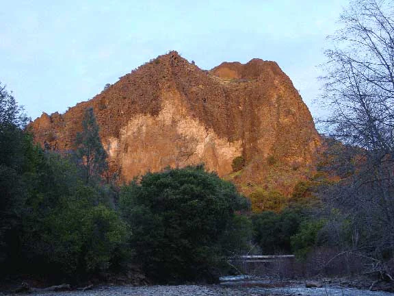
A large, craggy, reddish-brown rock formation rising above a forest canopy and a riverbed in the Ishi Wilderness.
Black Rock illuminated by the warm light of sunrise or sunset within the Ishi Wilderness.

Ishi Wilderness history and protected-area timeline

The cultural history of the Ishi Wilderness stretches back more than three thousand years, when ancestors of the Yahi Yana inhabited the rugged foothill country of what is now northern California, living along the Mill Creek and Deer Creek drainages and shaping a sustained presence in a landscape that others would later find nearly impenetrable.

This long heritage was disrupted after about 1850, as white settlers moved into the region and violence drove the Yahi population to near-extinction within a generation. A small remnant group survived by retreating into the wilderness, hiding for years in the remote canyons. The chapter came to a focal point in the early twentieth century with the emergence of Ishi, the last surviving Yahi, who became known to anthropologist Alfred L. Kroeber and whose name now defines the wilderness itself.

As a formal protected area, Ishi Wilderness has a much shorter history. It was created when the U.S. Congress passed the California Wilderness Act of 1984, which set aside the 41,339-acre area under the National Wilderness Preservation System. The land falls largely within the Lassen National Forest under U.S. Forest Service administration, with a small Bureau of Land Management parcel of around 240 acres. The designation as a federal wilderness came in recognition of both its ecological importance as a representative example of the southernmost Cascade foothills and its cultural significance as the homeland of the Yahi Yana. In recent years, the wilderness's history was further marked by the 2024 Park Fire, which burned almost the entire area.

Ishi Wilderness landscape and geographic character

The landscape of Ishi Wilderness is shaped by the interplay of volcanic geology and centuries of erosion by wind and water, producing a terrain that feels both rugged and exposed. East-west running ridges form the structural backbone of the area, with the highest ridges rising to about 4,000 feet. Between these ridges, two principal drainages, Deer Creek and Mill Creek, carve deep river canyons that eventually deliver their waters to the Sacramento River.

Volcanic origin is everywhere visible across the surface. Basalt outcroppings rise from the slopes, natural caves pierce the rock in places, and unusual pillar lava formations give parts of the wilderness a distinctive, almost sculptural quality. This combination of ridgelines, canyons, and volcanic features gives the area a strongly three-dimensional character, distinguishing it from the gentler foothill landscapes that lie closer to the Central Valley.

Ishi Wilderness ecosystems, habitats, and plant life

Ishi Wilderness captures one of the clearest expressions of Sierra/Cascade foothill ecology in California, a transitional belt where montane and lowland influences blend. The vegetation pattern follows slope aspect sharply. Sun-baked south-facing slopes are dominated by chaparral brush, a drought-adapted community of shrubs that thrives in the open, dry exposures. Cooler, moister north-facing slopes support pines and oaks, lending the hillsides a distinctly different texture between the two sides of each ridge. The riparian corridors along Deer Creek and Mill Creek form a third, especially lush ecological zone, where damp forests line the riverbanks and dense clusters of ponderosa pine grow on terraces within the canyon bottoms.

This layering makes the wilderness ecologically richer than its compact size would suggest, providing a gradient of habitats within short horizontal distances. The mosaic of chaparral, oak-pine woodland, and riparian forest also creates the conditions for abundant wildlife, while the cliff and canyon structures offer nesting and shelter microhabitats not found in the surrounding lowlands.

Ishi Wilderness wildlife and species highlights

Wildlife at Ishi Wilderness is closely tied to the foothill mosaic of chaparral, oak-pine woodland, and canyon forests. The area is especially noted as the winter range of the Tehama deer herd, considered the largest migratory deer herd in California, whose seasonal presence is a defining feature of the wilderness's mammal profile. The same mosaic supports mountain lions, American black bears, coyotes, bobcats, wild hogs, and rabbits, making the canyons and ridge slopes a functioning predator-prey landscape.

The cliff faces and rock outcrops that punctuate the ridges provide nesting habitat for a variety of raptors, including hawks, eagles, falcons, and owls. In the canyon and woodland environments, wild turkeys, quail, mourning doves, canyon wrens, and band-tailed pigeons are common, while numerous songbird species fill the riparian and oak habitats with seasonal activity. The combination of big-game winter range, a full set of mid-sized carnivores, and an unusually rich raptor presence makes the wildlife profile of Ishi Wilderness broader than many similarly sized foothill reserves. Because most of the area is also designated as a State Game Refuge where hunting is not permitted, the wildlife exists under relatively low levels of direct human harvest pressure.

Ishi Wilderness conservation status and protection priorities

The conservation significance of Ishi Wilderness rests on its role as the only California protected area that preserves a significant portion of the southernmost Cascade Range foothills. This status, granted through the California Wilderness Act of 1984 and maintained through its IUCN Category Ib wilderness designation, means the area anchors the protection of an entire foothill ecological zone rather than a single habitat type.

Several overlap protections reinforce this role. As a federal wilderness within the National Wilderness Preservation System, the area is managed to maintain its wilderness character. Most of the wilderness is also designated a State Game Refuge, where hunting is not permitted, allowing wildlife including the Tehama deer herd, mountain lions, and black bears to use the area under low-disturbance conditions. Special fishing regulations on Deer and Mill Creeks further limit pressure on aquatic communities. The cultural dimension of conservation is equally central: archaeological and historical sites linked to the Yahi Yana are protected under federal law, and the U.S. Forest Service actively encourages Leave No Trace practices to protect both natural and cultural integrity. A 2024 event, the Park Fire, burned nearly the entire area, marking a major recent impact on its ecological condition.

Ishi Wilderness cultural meaning and human context

The cultural identity of Ishi Wilderness is inseparable from the long history of the Yahi Yana people. The Yahi Yana inhabited this foothill country for thousands of years before Euro-American settlement, drawing on the canyons of Mill Creek and Deer Creek as both home and refuge. By the early 1850s, the arrival of settlers and the conflict that followed reduced the Yahi to a small remnant, who evaded contact for years by retreating into the wilderness's most rugged terrain.

The wilderness takes its name from Ishi, recognized as the last known member of the Yahi, who was brought into public life in the early twentieth century through his relationship with anthropologist Alfred L. Kroeber. This name binds the protected-area identity to a specific, documented human story within the landscape. Federal protection now extends explicitly to archaeological and historical sites and artifacts, which the U.S. Forest Service asks visitors to respect without disturbance. The management approach, including Leave No Trace practices and restricted activity in identified sites, treats the Yahi landscape as a continuing cultural landscape rather than merely a natural preserve.

Top sights and standout views in Ishi Wilderness

Ishi Wilderness stands out as the only California-protected area that preserves a significant portion of the southernmost Cascade Range foothills, combining volcanic landforms such as basalt outcroppings, caves, and pillar lava formations with a deeply incised river-canyon framework shaped by Deer Creek and Mill Creek.

Its ecological gradient, from chaparral on south-facing slopes to pine and oak woodland on north-facing slopes and dense ponderosa pine stands along the creeks, supports the largest migratory deer herd in California, a full suite of foothill carnivores, and a notable raptor and songbird presence. Layered on top of these natural qualities is a defining cultural dimension: the homeland of the Yahi Yana people, honored in the wilderness's name and protected through federal archaeological safeguards and Leave No Trace guidance.

Best time to visit Ishi Wilderness

The foothills of northern California have a Mediterranean-influenced climate with hot, dry summers and cool, wet winters, and the character of a visit to Ishi Wilderness shifts accordingly. Spring is often a rewarding time to visit, when the moister north-facing slopes and canyon bottoms are green, the creeks are flowing reliably, and temperatures are mild enough to make exploring the ridges and canyon rims comfortable.

Late fall and winter bring the seasonal arrival of the Tehama deer herd, which winters within the wilderness and is one of the area's most significant wildlife features. Summer visits can be rewarding for chaparral landscapes, raptors along the cliffs, and warm-weather creek exploration, but require attention to heat, sun exposure on south slopes, and dry conditions. Visitors should also keep in mind that, while the wilderness itself is broadly open, the area's archaeological sites and state game refuge status call for a low-impact, low-disturbance approach in any season.

Monthly climate preview

Track representative monthly averages across the protected terrain of California

Ishi Wilderness Climate Normals, Long-Term Temperature and Precipitation Rhythm

Long-term NASA records reveal the measured annual temperature and precipitation rhythm across a representative coordinate in Ishi Wilderness. Opening the complete monthly climate profile provides detailed historical baselines for temperature ranges and precipitation rates.
Annual mean16 °C
6 °C28 °C
Jan
Feb
Mar10°
Apr12°
May17°
Jun23°
Jul28°
Aug27°
Sep24°
Oct17°
Nov10°
Dec
Warmest month
July

27.7 °C

Coolest month
December

6.3 °C

Wettest month
December

5.7 mm/day

Driest month
July

0.1 mm/day

Park location guide

Geography guide, regional context, and park location map for Ishi Wilderness

Ishi Wilderness park geography, regions, and map view in United States of America

Understand where Ishi Wilderness sits in United States of America through a broader geographic reading of the surrounding landscape, nearby location context, and its mapped position within the national park landscape.

How Ishi Wilderness fits into United States of America

The United States of America is a federal presidential republic and one of the world's largest countries by area and population. It consists of 50 states across a vast territory spanning multiple time zones, with its capital in Washington, D.C. and largest city in New York City. The nation has a diverse economy, influential political system, and significant cultural and military presence globally.

Wider geography shaping Ishi Wilderness in United States of America

The United States occupies a vast territory in North America, bordered by Canada to the north and Mexico to the south. The 48 contiguous states stretch from the Atlantic to the Pacific Ocean, while Alaska occupies the northwestern region and Hawaii is an archipelago in the Pacific. The country encompasses diverse terrain including the Rocky Mountains, Appalachian Mountains, Great Plains, and extensive river systems.

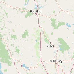
Map view of Ishi Wilderness

Use this park location map to pinpoint Ishi Wilderness in United States of America, understand its exact geographic position, and read its mapped placement within the surrounding landscape more clearly.

Pigeon | © OpenStreetMap contributors

Location context for Ishi Wilderness

California
Recorded earthquake history

Review the Ishi Wilderness Earthquake History and Seismic Records

Examine the historical catalogue of recorded seismic events occurring in the vicinity of Ishi Wilderness. This collection provides transparent access to USGS data for those interested in the documented seismic activity associated with these northern California foothills.

Ishi Wilderness Earthquake History

Catalogued events

154 events

Strongest magnitude

Magnitude 5.5

Most recent event

Jun 14, 2026

This history includes earthquakes recorded inside the park or within 50 km of its borders

Explore visual records of volcanic canyons, basalt formations, and foothill habitats

Ishi Wilderness Photos and Landscape Scenery: Visualizing Northern California Protected Areas

Visual records capture the rugged volcanic terrain, deep river canyons, and diverse forest habitats that define the protected landscape of Ishi Wilderness. Detailed photography helps researchers and visitors examine the unique geologic features and ecological gradients of the southern Cascade foothills.

A large, craggy, reddish-brown rock formation rising above a forest canopy and a riverbed in the Ishi Wilderness.

Park atlas

Compare adjacent volcanic terrain, river canyons, and regional foothill ecosystems.

Exploring Parks Near Ishi Wilderness and Surrounding Protected Natural Areas

Visitors exploring Ishi Wilderness can continue comparing regional protected areas across the surrounding northern California landscape. Expanding the geographic scope reveals connected forest reserves and volcanic terrain sharing similar ecological traits.
A wide watercolor illustration showing a calm body of water surrounded by green hills, conifer trees, and reeds in the foreground.
Protected landscapeCalifornia
Park boundaries overlap#1 closest

Northeast

Lassen National Forest: Mapped Geography and Protected Landscapes of Northern California

Volcanic terrain and expansive old growth ecosystems

Lassen National Forest represents a vast protected landscape in Northern California, defined by its severe volcanic geology and resilient conifer forests. This atlas entry provides essential geographic context regarding the forest boundaries, the volcanic rim of Mount Tehama, and the intricate river systems shaping the region. Explore the terrain, from accessible lava tubes to the wilderness areas preserved within this significant mountain corridor.

Area
4,331.53 km²
Established
1905
Relief
Mountain
Climate
Temperate
Protected landscapeCalifornia
20 km away#2 closest

East

Plumas National Forest: Mapped Geography and Protected Landscape Features in California

Exploring the Sierra Nevada watershed and wilderness terrain

Plumas National Forest serves as a critical protected landscape in northern California, anchoring the headwaters of the Feather River system. This atlas entry details the forest's rugged canyons, high elevation mountain lakes, and significant old growth conifer stands that define its role within the northern Sierra Nevada ecosystem.

Area
4,640 km²
Established
1907
Relief
Mountain
Climate
Mediterranean
National parkCalifornia
29 km away#3 closest

Northeast

Lassen Volcanic National Park: Protected Landscape Identity and Geographic Context

Discover the mapped boundaries and natural terrain of this California national park.

Gain a structured understanding of Lassen Volcanic National Park as a protected landscape. This detail page provides essential geographic context, focusing on the park's mapped boundaries and its specific terrain characteristics within California. It is designed for users seeking detailed information about the park's protected status and its placement within the broader atlas of natural areas, emphasizing its unique geographic identity and conservation significance.

Area
430.8 km²
Established
1916
IUCN
II
Visitors
504.8K annual
A soft watercolor painting depicting a serene landscape with gentle green hills, a small forest, and a calm lake at sunrise or sunset.
Protected landscapeCalifornia
63 km away#4 closest

Northwest

Shasta, Trinity National Forest: Mapping the Protected Landscapes of Northern California

Volcanic peaks, expansive reservoirs, and rugged mountain wilderness

Spanning over two million acres, Shasta, Trinity National Forest represents a major protected landscape in Northern California. The geography includes the iconic Mount Shasta volcano and the complex shoreline of Shasta Lake, while hosting expansive wilderness areas and diverse terrain ranging from oak-forested foothills to alpine meadows.

Area
8,942.87 km²
Established
1954
Relief
Mountain
Climate
Temperate
A watercolor illustration showing a soft, panoramic view of green trees and rolling hills against pale, pinkish-yellow mountains in the background.
Protected landscapeCalifornia
68 km away#5 closest

Southwest

Mendocino National Forest: Mapping California's Remote Protected Mountain Landscape

Examining wilderness boundaries and rugged coastal terrain

Mendocino National Forest serves as a significant protected area in California, known for being the only national forest in the state without major paved access. Its terrain spans 913,000 acres of mountain peaks, deep river canyons, and old-growth conifer forests. Home to the unique tule elk population at Lake Pillsbury, this landscape provides a rare example of wilderness isolation, complex geothermal features, and rugged, largely untouched northern coastal topography.

Area
3,696.02 km²
Established
1907
Relief
Mountain
Climate
Mediterranean
Protected landscapeCalifornia
69 km away#6 closest

Northwest

Whiskeytown, Shasta, Trinity National Recreation Area: Geographic and Protected Landscape Overview

Mapped terrain across northern California reservoir units

Investigate the environmental character of Whiskeytown, Shasta, Trinity National Recreation Area, spanning from the expansive waters of Shasta Lake to the forested ridges of the Whiskeytown unit. This atlas entry details the interplay between large-scale reservoir management, riparian habitats, and the transition from Mediterranean chaparral to high-elevation conifer forests in California.

Area
99,588 km²
Established
1965
IUCN
V
Visitors
1.5M annual
Protected landscapeCalifornia
77 km away#7 closest

Southeast

Tahoe National Forest: Exploring Protected Mountain Landscapes in the California Sierra Nevada

An atlas of granite river canyons and alpine ridge terrain

Tahoe National Forest defines a critical segment of the western Sierra Nevada, containing granite river canyons, numerous reservoirs, and summits reaching above 9,000 feet. This protected landscape acts as a vital headwater for California foothill communities and Nevada, hosting significant natural features like the Placer County Big Trees Grove and segments of the Pacific Crest Trail.

Area
3,526.82 km²
Established
1899
Relief
Mountain
Climate
Mediterranean
Protected landscapeCalifornia
95 km away#8 closest

Northeast

Modoc National Forest: Protected Landscape and Warner Mountains Geography

High desert volcanic terrain in northeastern California

Modoc National Forest encompasses a massive expanse of volcanic plateaus and rugged mountain ridges in the northeastern corner of California. This protected area offers significant geographic variety, transitioning from arid sagebrush basins to lush, high-elevation conifer forests. It serves as a vital natural landscape, home to the South Warner Wilderness and large stands of old-growth timber, reflecting the unique geologic history of the regional lava flows.

Area
6,695.09 km²
Established
1904
Relief
Mountain
Access
Moderate access

Common questions about visiting, size, designation, and location context for Ishi Wilderness

Ishi Wilderness FAQs for park facts, access, geography, and protected area context

Find quick answers about Ishi Wilderness, including protected-area facts, park geography, trail and visitor context, and how the park fits into its surrounding country and regional landscape.
MoriAtlas Explorer

Continue Your Protected Areas Search Across the Global Atlas

Deepen your exploration by continuing the structured search for national parks and protected areas worldwide. Utilize the comprehensive filtering capabilities to compare different conservation landscapes and refine your understanding of global park geography. Discover more about the distribution and characteristics of protected natural areas.

Global natural geography