Mori Atlas logo
Wildlife reserveIthala Game Reserve

Explore the distinct topography of this protected reserve, from the Ngotshe escarpment to the Pongola river system.

Ithala Game Reserve: Mapping the Rugged Mountains and Deep River Valleys of Northern KwaZulu-Natal

Ithala Game Reserve presents a dramatic mosaic of riverine forest, open savanna, and high-altitude grassland within the northern reaches of KwaZulu-Natal. This protected area, defined by its 1,000 metres of vertical relief, sits on the ancient Archaean crust of the Kaapvaal Craton. Visitors can trace the boundary between mountain ridges and low-lying thornveld, where unique geological layers and diverse vegetation communities support a reestablished wildlife population.

game reserveKwaZulu-Natalrugged terrainmountain escarpmentriverine forestthornveld

Ithala Game Reserve

Wildlife reserve

Park overview

Structured park overview, official facts, and landscape profile for Ithala Game Reserve

Ithala Game Reserve park facts, protected area profile, and essential visitor context

Review the core facts for Ithala Game Reserve, including designation, size, terrain, visitor scale, habitats, and operating context in one park-focused overview.

About Ithala Game Reserve

Ithala Game Reserve is a substantial protected area in northern KwaZulu-Natal, managed by Ezemvelo KZN Wildlife and recognised both nationally and internationally for its ecological and geological significance. It is positioned along the southern bank of the Pongola River, within a belt of country where the Grassland and Savanna biomes meet, and its terrain rises sharply from riverine lowveld to high-altitude mountain plateaus.

The defining physical characteristic of Ithala is its topographic range. The reserve climbs from around 400 metres along the Pongola floodplain to about 1,450 metres on the Ngotshe Mountains, producing a vertical drop of more than 1,000 metres within a relatively compact footprint. This gradient drives an unusual habitat sequence: riverine forest and wetland along the larger streams, dense bushveld and thornveld on the lower slopes, mixed savanna and woodland through the middle altitudes, and open sourveld grassland on the high plateaus and ridges. The dramatic cliffs, dolerite spires, and banded sandstone formations of the Ngotshe escarpment create some of the most visually distinctive scenery of any South African game reserve.

The reserve's geological context is equally arresting. It lies on the southeastern margin of the Kaapvaal Craton, one of only two remaining areas of pristine Archaean crust on Earth, and contains rock formations roughly three billion years old, including granite, gneiss, quartzite, ironstone, dolomite, and extensive sandstone. These varied substrates contribute to exceptional botanical diversity, with around 910 plant species documented across 13 vegetation communities and over 320 tree species recorded.

When the Natal Parks Board began acquiring the land in 1973, much of the area was overgrazed farmland with very little wildlife left. The contemporary reserve is, in many respects, a constructed ecosystem, rebuilt through systematic reintroduction of historically native species. Today it supports four of the Big Five, healthy populations of giraffe and tsessebe, and a recognised Important Bird Area that includes breeding populations of blue crane and southern bald ibis. The absence of lions contributes to unusually calm prey behaviour, which in turn shapes the game viewing experience.

Quick facts and research context for Ithala Game Reserve

Ithala Game Reserve lies in northern KwaZulu-Natal, South Africa, in the transitional zone between the Grassland and Savanna biomes. It covers roughly 296 square kilometres and was formally proclaimed as a game reserve in 1973, with the land having been progressively purchased from former farms by what is now Ezemvelo KZN Wildlife.

The reserve sits on the Kaapvaal Craton and contains Archaean-age rock formations dating back around three billion years. It supports approximately 910 plant species, about 80 mammal species, and over 300 bird species, including threatened species such as blue crane, southern bald ibis, and the vulnerable Protea comptonii.

Protection and recognition

Examine documented protection metrics and official conservation boundaries for Ithala Game Reserve.

Ithala Game Reserve Protection Status and Designated Terrestrial Scope

Terrestrial protection status and administrative management records establish the formal conservation framework governing Ithala Game Reserve. Structured designation data and international recognition metrics outline the recorded boundaries protecting this conservation landscape.

Protection details

Protection scope
Terrestrial
Transboundary protection
No
Park context

Deeper park guide and search-rich context for Ithala Game Reserve

Ithala Game Reserve history, landscape, wildlife, and travel context

Explore Ithala Game Reserve through its history, landscape character, ecosystems, wildlife, conservation priorities, cultural context, and seasonal travel timing in a structured park guide built for atlas discovery and search intent.

Why Ithala Game Reserve stands out

Ithala is known primarily for its combination of exceptionally rugged scenery and ancient geology. The Ngotshe Mountains form a dramatic backdrop, with bands of pink and russet sandstone, vertical dolerite spires, and deeply incised river valleys dropping more than 1,000 metres toward the Pongola River. Ecologically, the reserve is distinguished by the recovery effort behind its modern wildlife populations. Twenty-three mammal species have been reintroduced since the reserve's establishment, including white and black rhinoceros, African buffalo, African elephants (introduced in 1990), tsessebe, and giraffe. It is the only location in KwaZulu-Natal where tsessebe occur in herds, and the only place in the province where the vulnerable saddleback sugarbush, Protea comptonii, is found.
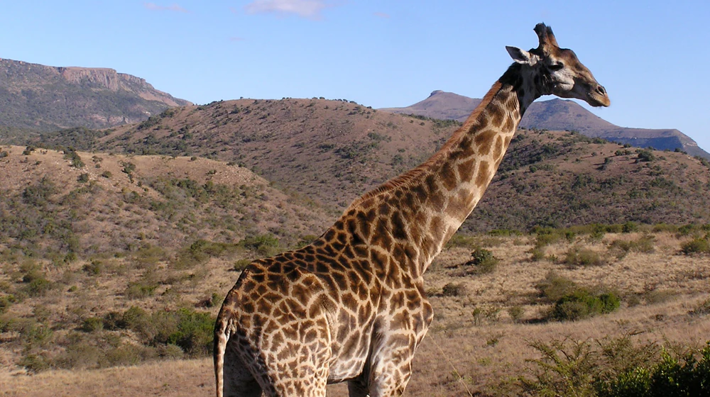
A giraffe stands in profile against a backdrop of arid hills and clear blue sky in South Africa.
A giraffe standing in the rugged, hilly landscape of Ithala Game Reserve.

Ithala Game Reserve history and protected-area timeline

The Ithala area has a deep human history extending back hundreds of thousands of years. Middle Stone Age tools dating to around 200,000 years ago and numerous Later Stone Age spear and axe heads from roughly 20,000 years ago have been found within the reserve. San hunter-gatherers occupied the region and left rock art in shelters in the eastern part of the reserve. Later, Iron Age communities smelted iron using the local banded ironstone deposits, fuelled largely by wild olive wood, producing mainly spear tips known as assegais. During the era of the Zulu Kingdom, the caves along the Ngotshe cliff faces sheltered people fleeing conflicts, leaving traces that can still be identified.

Following the Anglo-Zulu War of 1879, the political landscape was reshaped as Boer settlers from the Utrecht and Wakkerstroom districts allied with Dinuzulu kaCetshwayo. After the Battle of Tshaneni in June 1884, they were granted a vast tract of northern Zululand, and on 5 August 1884 the Nieuwe Republiek was formally established with Vryheid as its capital. The Ithala area fell within this short-lived republic. Before European settlement, game was abundant, but hunting by settlers, the rinderpest epidemic of 1896, and later decades of agricultural use severely depleted wildlife populations and triggered soil erosion across the region.

A small gold-mining era also left its mark. The Wonder Mine, developed from 1905 and worked until 1933, produced 147 kilograms of gold, while the nearby Vergelegen and later Ngotshe mines operated intermittently between 1913 and 1967. These abandoned workings now lie within the reserve. Between 1919 and the early 1950s, colonial anti-nagana campaigns wiped out large numbers of wild animals in Zululand in an attempt to control tsetse fly populations, and some species, including the red-billed oxpecker, became locally extinct.

By the time the Natal Parks Board began purchasing farms in the area in 1973, the land was heavily degraded and only fragments of the original fauna survived. The reserve was officially proclaimed that year on roughly 8,000 hectares. Using historical records from the older Pongola Game Reserve, conservationists identified the lost species and reintroduced them; by 1982 the reserve had expanded to nearly 30,000 hectares, and 23 mammal species had been re-established. A herd of African elephants was introduced in 1990 and has since matured into a stable breeding group.

Ithala Game Reserve landscape and geographic character

Ithala's landscape is dominated by the Ngotshe Mountains along its southern edge and the deeply incised Pongola River system along its northern boundary. The escarpment climbs to about 1,450 metres and falls sharply to the river at roughly 400 metres, giving the reserve more than 1,000 metres of vertical relief within a relatively small area. The result is a layered topography of mountain ridges, cliff faces, rolling hills, river valleys, and low-lying thornveld plains.

The visual character of the mountains is striking. Horizontal bands of pink and russet sandstone alternate with vertical columns of dark dolerite, creating jagged spires, exposed cliff faces, and coloured rock outcrops visible from many kilometres away. Below the escarpment, the terrain breaks into a network of valleys shaped by the Ngubhu, Mbizo, Thalu, and Bivane rivers, all flowing northward to join the Pongola. These valleys carry dense riverine vegetation, contrasting with the open grassy plateaus above.

This relief combines with the reserve's position on the Grassland-Savanna transition to produce distinctive habitat zones. Low-lying areas along the Pongola support bushveld and thornveld, mid-altitudes are dominated by open woodland and mixed savanna, and the high plateaus carry sourveld grassland. The interplay between rock, soil, elevation, and moisture is what underpins Ithala's unusually high biological diversity.

Ithala Game Reserve ecosystems, habitats, and plant life

Ithala's ecological identity is built around the interaction between its extreme altitudinal range, diverse geology, and position between two major biomes. The reserve supports thirteen distinct vegetation communities and an estimated 910 plant species, including around 320 tree species. Major vegetation types include Ithala Quartzite Sourveld, Northern Zululand Mistbelt Grassland, riverine thicket and forest along watercourses, dense bushveld and thornveld at lower altitudes, and open sourveld grassland on the high plateaus.

The reserve's botanical importance is anchored by rare and locally endemic species. Ithala is the only location in KwaZulu-Natal where the vulnerable saddleback sugarbush (Protea comptonii) occurs, with roughly 1,100 mature individuals divided across several small subpopulations. Other rare taxa include Searsia pondoensis, the pepper-bark tree (Warburgia salutaris), Gonioma kamassi, Syzygium legattii, Aloe vryheidensis, and several localised endemics such as Dracosciadium italae and Melanospermum italae. Characteristic trees of the broader landscape include various Acacia species in the thornveld, wild fig (Ficus), cabbage tree (Cussonia), and candelabra tree (Euphorbia ingens).

Wetland and riverine systems along the Ngubhu, Mbizo, Thalu, Bivane, and Pongola rivers play an important role in maintaining the reserve's moisture-dependent habitats and supporting the dense vegetation corridors that link the lower and middle altitudes. The variability in soils derived from granite, gneiss, quartzite, ironstone, dolomite, and sandstone accelerates plant community turnover across short distances.

Ithala Game Reserve wildlife and species highlights

Ithala supports roughly 80 mammal species, many of them the product of deliberate reintroduction. Four of the Big Five are present: African elephant, African buffalo, leopard, and both white and black rhinoceros. Lions have not been reintroduced, which gives prey species an unusually relaxed behaviour pattern and contributes to the reserve's strong game viewing atmosphere.

The reserve's identity is strongly tied to several signature species. South African giraffe are abundant and visually iconic, Ithala is the only place in KwaZulu-Natal where tsessebe, the fastest-running antelope in Africa, occurs in herds, and African elephants form a well-established breeding herd since their introduction in 1990. Other notable grazers and browsers include impala, red hartebeest, blue wildebeest, eland, reedbuck, mountain reedbuck, plains zebra, warthog, common duiker, bushbuck, nyala, and greater kudu.

Predators include leopard, brown hyena, spotted hyena (rarely seen), cheetah, serval, and African wildcat. Rare and endangered mammals present include greater bushbaby, honey badger, ground pangolin, and oribi, with rock hyrax (dassie) being a familiar presence around Ntshondwe Camp. The reserve's birdlife is similarly significant, with over 300 recorded species and an Important Bird Area designation. Globally threatened breeders include blue crane and southern bald ibis, while large raptors such as white-backed vulture, lappet-faced vulture, martial eagle, bateleur, crowned eagle, and Verreaux's eagle are regularly seen, the last soaring above the cliffs at Ntshondwe. The red-billed oxpecker, lost to the area during anti-nagana campaigns, was reintroduced from Kruger National Park in 1994 and has since re-established breeding.

Ithala Game Reserve conservation status and protection priorities

Ithala Game Reserve is owned by the South African State and administered by Ezemvelo KZN Wildlife. The reserve is a IUCN Category IV protected area (habitat/species management area), and its conservation significance lies both in what it preserves and in what it has restored. After decades of farming, overgrazing, soil erosion, and the depletion of wildlife through hunting, disease, and anti-nagana campaigns, the landscape has been actively rehabilitated since 1973.

The reserve's importance is partly geological: by protecting exposures of Archaean crust on the Kaapvaal Craton roughly three billion years old, it preserves features of global scientific interest. Ecologically, it safeguards thirteen distinct vegetation communities, the only KwaZulu-Natal population of the vulnerable Protea comptonii, and habitat for threatened birds such as blue crane and southern bald ibis. Key ongoing conservation concerns include invasive alien plants (with re-infestation from the unconserved north bank of the Pongola complicating control), legacy soil erosion, inappropriate fire regimes that threaten fire-sensitive species, and browsing pressure from reintroduced antelope on sensitive plants such as the saddleback sugarbush. The systematic reintroduction of 23 mammal species, including both rhinoceros species and elephants, marks Ithala as one of South Africa's more complete habitat reconstruction case studies.

Ithala Game Reserve cultural meaning and human context

The Ithala area carries a layered human history that fuses deep prehistoric occupation with later Iron Age metallurgy and the turbulent politics of nineteenth-century southern Africa. San hunter-gatherers left rock art in shelters in the eastern reserve, and the banded ironstone formations were once exploited by Iron Age communities for iron smelting, mainly to produce spear tips in clay furnaces fuelled by wild olive wood.

The region also sits within the historical territory of the Zulu Kingdom and was drawn into the conflicts of the late nineteenth century, when the caves along the Ngotshe cliff faces sheltered people fleeing violence. The founding of the short-lived Nieuwe Republiek in 1884, with Vryheid as its capital, places Ithala within a distinctive political chapter of South African history. The reserve's name itself, "Ithala," is the isiZulu word for "the shelf," reflecting the prominence of isiZulu as both a living language of the region and a marker of local cultural identity, also visible today in the naming of camps such as Ntshondwe.

Top sights and standout views in Ithala Game Reserve

Ithala's standout qualities are the combination of dramatic mountain-and-river scenery, an Archaean geological setting on the Kaapvaal Craton, and a wildlife community rebuilt through one of South Africa's more extensive reintroduction programmes. The Ngotshe escarpment, with its sandstone colour bands and dolerite spires, gives the reserve one of the most recognisable skylines in KwaZulu-Natal.

The reserve is also distinguished by several specific firsts and rarities: it is the only location in KwaZulu-Natal with a persistent population of tsessebe and the only known provincial home of the vulnerable saddleback sugarbush, while its reintroduced herds of rhinoceros, buffalo, and elephants anchor a diverse Big Four game viewing profile that is notable for the absence of lions and the resulting calm prey behaviour.

Best time to visit Ithala Game Reserve

Ithala's seasonal character is shaped by a warm climate with clearly defined wet and dry periods. The rainy season runs roughly from October to April, when greenery, migratory birds, and active grasslands are at their peak. Annual rainfall increases significantly with altitude, from around 680 millimetres in the eastern valleys to 1,200 millimetres on the high plateau, which means higher-lying areas remain green and lush well into the warmer months.

The dry winter months from May to September bring warm days, cold nights, and occasional frost at higher elevations. This cooler, drier period offers easier wildlife viewing as animals concentrate around water and along the major rivers, while the southern bald ibis breeds on the cliffs between July and October. Migratory birds are at their richest between November and April, making shoulder seasons particularly rewarding for visitors interested in both landscape and birding conditions.
Monthly climate preview

Long-term average temperature and monthly precipitation patterns measured at representative coordinates

Ithala Game Reserve Climate Normals and Annual Weather Rhythms

Ithala Game Reserve exhibits a measured annual cycle of long-term average temperatures and monthly precipitation rates recorded across twelve distinct periods. Exploring the complete monthly profile provides detailed context on historical climate normals without relying on live forecasts.
Annual mean19 °C
13 °C22 °C
Jan22°
Feb22°
Mar21°
Apr19°
May16°
Jun14°
Jul13°
Aug16°
Sep19°
Oct20°
Nov21°
Dec22°
Warmest month
January

22.4 °C

Coolest month
July

13.4 °C

Wettest month
December

4.6 mm/day

Driest month
June

0.5 mm/day

Park location guide

Geography guide, regional context, and park location map for Ithala Game Reserve

Ithala Game Reserve park geography, regions, and map view in South Africa

Understand where Ithala Game Reserve sits in South Africa through a broader geographic reading of the surrounding landscape, nearby location context, and its mapped position within the national park landscape.

How Ithala Game Reserve fits into South Africa

South Africa is the southernmost country in Africa, spanning 1.22 million km² with a population of over 63 million. The country operates with three capital cities, Pretoria (executive), Cape Town (legislative), and Bloemfontein (judicial), and is renowned for its biodiversity, national parks, and multicultural society.

Wider geography shaping Ithala Game Reserve in South Africa

South Africa occupies the southernmost region of Africa, with coastline along both the Atlantic Ocean to the west and the Indian Ocean to the east. The interior features elevated plateaus including the Highveld, with the Drakensberg escarpment marking the eastern highlands. The country shares borders with Namibia, Botswana, Zimbabwe, Mozambique, Eswatini, and Lesotho.

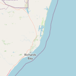
Map view of Ithala Game Reserve

Use this park location map to pinpoint Ithala Game Reserve in South Africa, understand its exact geographic position, and read its mapped placement within the surrounding landscape more clearly.

Pigeon | © OpenStreetMap contributors

Location context for Ithala Game Reserve

KwaZulu-Natal

Explore photographic records of ancient geological formations, escarpments, and diverse protected habitats.

Ithala Game Reserve Photos and Landscape Scenery Visual Reference

Visual records illustrate the rugged terrain, steep mountain escarpments, and varied vegetation zones found across the protected area. Examining field photography helps researchers and visitors analyze the distinctive topography and ecological contrasts defining the reserve.

A giraffe stands in profile against a backdrop of arid hills and clear blue sky in South Africa.

Park atlas

Compare regional wildlife sanctuaries and connected conservation landscapes

Parks Near Ithala Game Reserve and Surrounding Protected Areas

Browse other protected areas near Ithala Game Reserve to examine shared regional terrain, river valleys, and escarpment habitats. Comparing adjacent reserves expands geographical context across the surrounding KwaZuluNatal conservation network.
Nature reserveKwaZulu-Natal
About 60 km away#1 closest

East

Phongolo Nature Reserve: Mapped Protected Landscapes of Northern KwaZulu-Natal

Historic reserve terrain at the Lebombo escarpment

Spanning over 10,000 hectares, Phongolo Nature Reserve represents a critical geographic unit defined by the Pongolapoort Dam and the surrounding Lebombo range. Its terrain transitions from clay-rich lowveld plains to dramatic high-altitude rocky escarpments, forming a complex protected environment within the KwaZulu-Natal borderlands. Explore the mapped extent and structural biodiversity of this long-standing South African conservation site.

Area
104.85 km²
Established
1894
IUCN
IV
Relief
Mountain
A soft, artistic watercolor painting showing rolling green hills in the background with a winding path and fields in the foreground, set against a white background.
Wildlife reserveKwaZulu-Natal
About 85 km away#2 closest

South

Babanango Game Reserve: Exploring Geographic Boundaries and Rewilding Landscapes

Protected wildlife habitats in central KwaZulu-Natal

Centrally positioned in the White Umfolozi River valley, Babanango Game Reserve serves as a model for large-scale biodiversity restoration. Its terrain features a mix of mistbelt grasslands, thornveld, and river frontage supported by ancient geological structures. The reserve preserves both ecological integrity and cultural heritage near historic sites, reflecting a shift toward community-led conservation in modern South African landscape management.

Area
200 km²
Established
2017
Relief
Mixed relief
Climate
Subtropical
Nature reserveKwaZulu-Natal
About 99 km away#3 closest

Southeast

Hluhluwe, Imfolozi Park Nature Reserve: Detailed Protected Area and Regional Geography

Explore mapped boundaries and landscape context in KwaZulu-Natal.

Hluhluwe, Imfolozi Park, designated as a nature reserve, offers a distinct protected landscape within KwaZulu-Natal, South Africa. This entity page provides an atlas-focused view, emphasizing the park's mapped boundaries and its contribution to the region's protected area network. Understand its geographic setting and unique landscape character through structured data, essential for any explorer keen on mapping protected lands.

Area
960 km²
Established
1895
Relief
Mountain
Climate
Subtropical
A watercolor landscape illustration showing soft, blended washes of light green, yellow, and pale pink, depicting rolling hills and sparse trees against a white background.
Wildlife reserveKwaZulu-Natal
About 108 km away#4 closest

Northeast

Ndumo Game Reserve: Geographic Atlas and Protected Landscape Overview

Wetlands and riverine ecosystems of Maputaland, KwaZulu-Natal

Ndumo Game Reserve represents a distinct protected landscape where the Pongola and Great Usutu rivers shape a dense mosaic of pans, floodplains, and sand forests. As a Ramsar site, this compact wildlife reserve serves as an essential case study in regional geography and the conservation of riverine corridors along the Mozambique border.

Area
102 km²
Established
1924
Relief
Lowland
Climate
Subtropical
Protected areaKwaZulu-Natal
About 123 km away#5 closest

East

Lake Sibaya Protected Area: Mapping the Freshwater Heart of the KwaZulu-Natal Coast

Freshwater wetlands and coastal dune forest topography

Lake Sibaya encompasses the largest freshwater basin in South Africa, defined by its position near the Maputaland coast. The landscape represents a significant freshwater interface between coastal dune forests and the Indian Ocean, serving as an important protected study site for catchment ecosystems, water-bird habitats, and regional hydrological diversity.

Area
64 km²
Established
1991
Relief
Lowland
Climate
Subtropical
Wildlife reserveKwaZulu-Natal
About 126 km away#6 closest

South

Thula Thula Private Game Reserve: Protected Wildlife Habitats and Geography

Bushveld and riverine geography in the KwaZulu-Natal Zululand corridor

Thula Thula Private Game Reserve features a unique intersection of bushveld habitats and river systems within South Africa. This reserve provides important protected land for elephants, rhinoceros, and over 350 avian species. It remains a key geographic entity for understanding the Royal Zulu Biosphere and the conservation history of the northeastern KwaZulu-Natal region.

Area
45 km²
Established
1911
Scope
Terrestrial
A soft watercolor painting of a serene lakeside landscape with green rolling hills and calm water.
Protected areaKwaZulu-Natal
About 148 km away#7 closest

East

Kosi Bay Protected Area: Mapped Geography and Coastal Lake Systems in KwaZulu-Natal

Coastal lake geography and protected wetland boundaries

Kosi Bay forms a complex wetland chain in KwaZulu-Natal, characterized by four linked lakes and a clear estuary mouth. The terrain transitions from coastal dunes and sandy beaches to mangrove-lined channels and Maputaland forest, providing a rich study of regional water systems and protected land boundaries.

Established
1991
Water
Water-dominated
Season
Year-round
National parkEswatini
About 150 km away#8 closest

North

Hlane Royal National Park: Eswatini's Vast Protected Savanna Woodland Landscape

Mapped geography and protected area context in northeastern Eswatini.

Delve into Hlane Royal National Park, Eswatini's most extensive protected territory, a prime example of lowland bushveld savanna. This national park is defined by its expansive woodland terrain, dotted with ancient trees and seasonal water pans, creating a dynamic landscape. It is an essential component for understanding the regional geography and the distribution of protected areas within Southern Africa, offering significant opportunities for landscape exploration.

Area
300 km²
IUCN
VI
Relief
Lowland
Climate
Subtropical

Common questions about visiting, size, designation, and location context for Ithala Game Reserve

Ithala Game Reserve FAQs for park facts, access, geography, and protected area context

Find quick answers about Ithala Game Reserve, including protected-area facts, park geography, trail and visitor context, and how the park fits into its surrounding country and regional landscape.
MoriAtlas Explorer

Continue Your Protected Areas Search Across the Global Atlas

Deepen your exploration by continuing the structured search for national parks and protected areas worldwide. Utilize the comprehensive filtering capabilities to compare different conservation landscapes and refine your understanding of global park geography. Discover more about the distribution and characteristics of protected natural areas.

Global natural geography