

Why Jerrabomberra Wetlands Nature Reserve stands out
Jerrabomberra Wetlands is best known as a major summer feeding ground for Latham's Snipe, a protected migratory waterbird listed under Australia's Environment Protection and Biodiversity Conservation Act. The reserve also stands out for its dense concentration of small but ecologically rich wetlands inside a national capital, including a mix of permanent wetlands, ephemeral pools, and ancient Molonglo River palaeochannels. It supports significant numbers of waterbirds, woodland birds, native frogs, platypus, eastern long-necked turtles, and rakali, and is recognised as a federal Matter of National Environmental Significance.
Jerrabomberra Wetlands Nature Reserve history and protected-area timeline
The floodplain that Jerrabomberra Wetlands now protects has been lived on for at least 25,000 years. The Ngunnawal and Ngambri peoples, the traditional custodians of the Canberra region, used the Molonglo River and its associated pools, creeks, and floodplain grasslands as a source of food, plant materials, fibres, and medicine. Stone tools found around the nearby Pialligo area, historically known as Biyaligee, suggest a substantial lowland campsite was once located close to today's reserve. Jerrabomberra Creek, also called Girimbombery or Giridombera, is recognised by the Ngunnawal people as a spiritual pathway that guided visitors from the south to the central corroboree grounds on the Molonglo River floodplain. The last corroboree known to have occurred on the floodplain took place in 1862.
European settlement of the area began in the early nineteenth century. The earliest written accounts, dating to 1820, describe a predominantly grassland landscape set below wooded hills and ridges, an environment later known as the Limestone Plains. In 1820 Robert Campbell acquired a 5,000-acre block of land that included what is now part of the reserve, merging it with his Pialligo estate, later known as Duntroon. Sheep were run near the confluence of the Molonglo River and Jerrabomberra Creek, lucerne was grown on the black soil flats, and willows were planted along the Molonglo River in the mid-nineteenth century, though willows are now regarded as a major pest.
Periodic flooding and drought shaped nineteenth-century land use. Landholders began ringbarking trees around 1880 to reduce water use and slow the drying of local streams, and the arrival of the railway at nearby Queanbeyan in 1887 accelerated agricultural production. The floodplain was also called Mill Flat, because a windmill used to grind wheat once stood on the Duntroon estate, with Jerrabomberra Creek itself then known as Mill Creek. The original mill was destroyed by storms in 1874.
In 1911 the area now forming the Australian Capital Territory was designated as the Federal Capital Territory, and in 1912 the Commonwealth Government acquired the farmed land. During World War I the nearby Royal Military College used Mill Flat for military training, and in 2015 trial excavations within the present reserve uncovered a substantial trench system once used by the Trench Warfare and Bombing School at Duntroon. After the War, Mill Flat was divided into lucerne leases to resettle returned soldiers, but major floods in 1922 and 1925 made these smallholdings unworkable, and the land was reorganised as commercial dairy leases in 1926, giving the area its later name, Dairy Flat.
The transformation that created today's wetlands began with the construction of Lake Burley Griffin. Walter Burley Griffin's plan for an East Lake envisaged a much larger body of water over the floodplain, but a smaller lake was ultimately built after the embankment across the Molonglo River was breached by floods in 1922 and 1925. When the dam was finally closed in 1964, the resulting lake raised the groundwater under the floodplain and permanently inundated part of the plain, establishing the conditions from which Jerrabomberra Wetlands would later be recognised as a protected area.
From the mid-1970s, environmental advocates argued for formal protection of the wetlands, citing their wildlife values and their potential for education and ecological research. The Jerrabomberra Wetlands Advisory Group held its first meeting in September 1987, and in 1988 a draft policy plan was produced for the area. In 1990 the first part of the reserve was officially gazetted under the Nature Conservation Act 1980, accompanied by the construction of bird hides, fencing, plantings, and other visitor facilities. In 2011 the ACT Government established the Woodlands and Wetlands Trust to oversee conservation management of both Jerrabomberra Wetlands and Mulligans Flat Woodland Sanctuary. The reserve was placed on the ACT Heritage Register in 1988 and was considered for further protection under the Heritage Act 2004 in 2018.
Jerrabomberra Wetlands Nature Reserve landscape and geographic character
The Jerrabomberra Wetlands landscape is defined by the flat to gently undulating floodplain of the Molonglo River and Jerrabomberra Creek, surrounded by the low hills and ridges of central Canberra. Within this setting, the reserve is a tightly woven mosaic of open water, reedbeds, wet meadows, palaeochannels, and floodplain grasslands.
The reserve contains around 27 separate wetlands, all relatively small and mostly less than 1.5 metres deep. These range from permanently wet basins with stable or seasonally fluctuating water levels to ephemeral pools that only hold water after rainfall. Shoveler Pool and the Jerrabomberra Backwaters are perched temporary wetlands that reflect groundwater conditions rather than direct river flows, while Kelly's Swamp and Jerrabomberra Billabong are deeper "window" wetlands that intersect a shallow aquifer of silt, sand, and gravel underlying the floodplain.
The Jerrabomberra Backwaters are a particularly important landscape element. They are palaeochannels, traces of old courses of the Molonglo River from earlier geological times, formed as the river flooded and shifted across the floodplain. When Lake Burley Griffin was formed, much of the lower course of Jerrabomberra Creek was diverted and flooded, and the now-submerged channel sections intersect these palaeochannels to create a distinctive pattern of backwaters.
Other features of the reserve's surface are products of human activity as well as natural processes. Some raised landforms, including levee banks, embankments, and the mounds supporting electricity transmission towers, were created when builders' spoil and fill from large excavations such as the building of Parliament House at Capital Hill was dumped on the floodplain. The Monaro Highway embankment also crosses the area. Two of the 27 wetlands have been deliberately constructed as water-quality treatment basins, capturing and holding water from Jerrabomberra Creek long enough for contaminants to settle before the water passes on toward Lake Burley Griffin, the lower Molonglo River, and ultimately the Murrumbidgee River system.
Jerrabomberra Wetlands Nature Reserve ecosystems, habitats, and plant life
The ecological character of Jerrabomberra Wetlands is built around the interaction of water, vegetation, and floodplain soil. The reserve supports a layered habitat structure in which open water, reedbeds, wet meadows, grasslands, planted woodlands, and remnant native patches occur side by side. This habitat diversity is widely considered the main reason the reserve supports such high waterbird numbers within a relatively small area.
Vegetation at the reserve is a mix of remnant plant communities and others that have been substantially modified since European settlement. Woodlands cover around 23 percent of the area and were planted largely in the 1990s, often using Australian species not necessarily local to the Canberra district. Grasslands dominated by introduced agricultural grasses and weeds cover around 66 percent, although scattered native plants have self-established throughout. Wetland and riparian vegetation has mostly regenerated naturally from seeds and plant fragments carried in by wind, water, and animals. As a result, only around 68 indigenous species have been recorded among the 293 plant species mapped across the reserve.
Ten different wetland vegetation types have been mapped, varying from rushlands and reedlands about three metres tall down to herbfields less than ten centimetres tall. Some wetland species recorded here, including Baumea articulata, Lemna disperma, Eleocharis atricha, Eleocharis sphacelata, Limosella australis, and Schoenoplectus pungens, are rarely recorded elsewhere in the ACT. In some cases self-established wetland vegetation at the reserve closely resembles communities that occur naturally across the nearby New South Wales border.
The reserve's four main water sources are direct rainfall, stormwater and surface runoff from nearby industrial areas, sewage treatment ponds, a turf farm, and future residential developments, periodic flooding from the Molonglo River and Jerrabomberra Creek, and groundwater inflows from two shallow aquifers beneath the floodplain. This combination of meteorological, surface, and groundwater inputs means that wetland water levels fluctuate naturally, and naturally dry periods are treated as an important part of the wetland life cycle. A revegetation program run by the Friends of Jerrabomberra Wetlands and ACT Parks and Conservation Service aims to replace invasive plants with native casuarinas and other riparian species to improve habitat quality over time.
Jerrabomberra Wetlands Nature Reserve wildlife and species highlights
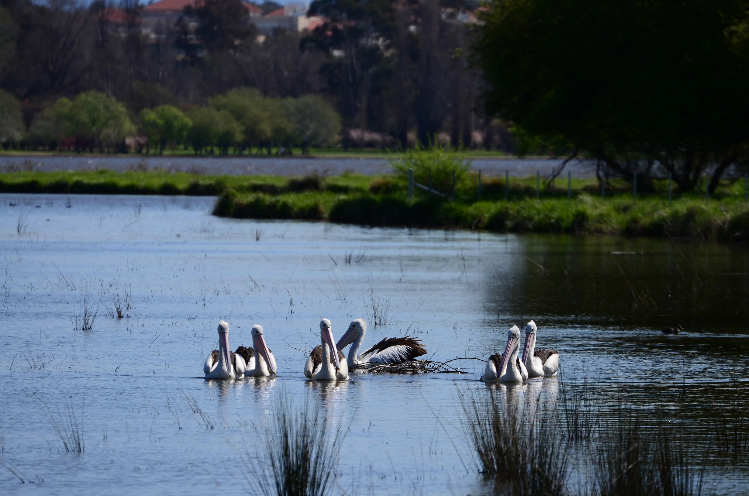
Jerrabomberra Wetlands is most renowned for its rich bird life. More than 170 species of wetland, woodland, and grassland birds have been recorded in and around the reserve, and 77 species of waterbirds have been observed using the site, with 16 of those confirmed as breeding locally. Eight species of international migratory birds use the reserve across the seasons, and the reserve also hosts occasional vagrant and uncommon waders such as the Common Sandpiper and the Sharp-tailed Sandpiper.
The reserve is a recognised summer feeding ground for Latham's Snipe, a migratory waterbird that breeds in northern Asia and winters in Australia. The species is protected under Australia's Environment Protection and Biodiversity Conservation Act 1999 and is covered by international migratory bird agreements with China, Japan, and the Republic of Korea. Because of the numbers of Latham's Snipe present, including a count of 60 individuals during the 2020 to 2021 season, the reserve is considered a federal Matter of National Environmental Significance. Individual snipe have been leg-banded as part of an international study of the species' ecology.
Other threatened and notable bird species recorded at the reserve include the Australasian Bittern and the Australian Painted-snipe, both regarded as endangered. Beyond the reserve boundary, birds also use the nearby sewage treatment ponds and turf farm as additional shelter and feeding habitat, extending the available habitat network across the urban landscape.
Native mammals recorded at the reserve include the Platypus, which uses the Molonglo River, Jerrabomberra Creek, and the wetlands themselves, and the Rakali, or water rat, a native semi-aquatic rodent. Eastern Long-necked Turtles occur in the wetlands, with nesting occurring between November and January in the Canberra region; conservation volunteers run a program to protect nests and hatchlings from fox predation, a major threat to local turtle populations. Seven frog species have been recorded at the reserve, including Common Eastern Froglet, Spotted Marsh Frog, Banjo Frog, Striped Marsh Frog, and several Peron's tree frog and Verreaux's frog species. Endangered fish, including Macquarie Perch and Silver Perch, have been recorded in the Molonglo River, alongside recreational species such as Murray Cod and Golden Perch. Introduced fish such as Common Carp, Eastern Gambusia, and Redfin are recognised as significant ecological threats because they disturb sediments, consume native eggs, and predate on smaller native fish.
Jerrabomberra Wetlands Nature Reserve conservation status and protection priorities
Jerrabomberra Wetlands is nationally significant for conservation because it supports protected migratory species, threatened waterbirds, and a high concentration of wetland-dependent wildlife within an urbanised national capital. Its standing as a regular summer feeding ground for Latham's Snipe in numbers large enough to qualify as a federal Matter of National Environmental Significance places it among the most important inland sites for migratory waterbird conservation in south-eastern Australia.
The reserve's conservation significance is underpinned by formal recognition. The first part of the reserve was gazetted under the Nature Conservation Act 1980 in 1990, and the wetlands were placed on the ACT Heritage Register in 1988 to be maintained and managed as a wetland habitat. In 2018 the area was considered for further protection under the Heritage Act 2004 as part of the broader Canberra Nature Park system, and in 2011 the ACT Government established the Woodlands and Wetlands Trust to coordinate conservation management of Jerrabomberra Wetlands and Mulligans Flat Woodland Sanctuary at the northern edge of the territory.
Conservation management addresses several ongoing pressures. Introduced pest plants, including willows that spread from nineteenth-century plantings, are subject to ongoing removal by ACT Parks and Conservation Service staff and the Friends of Jerrabomberra Wetlands. Common Carp, Eastern Gambusia, and Redfin are recognised as significant ecological threats to fish and frog populations because they disturb sediments, consume native eggs, and prey on small native species. Foxes are managed as a key threat to native fauna, particularly turtle nests and hatchlings.
The reserve is also a focal point for citizen science and community engagement in conservation. Volunteer programs run by the Friends of Jerrabomberra Wetlands, in partnership with ACT Parks and Conservation Service and the Woodlands and Wetlands Trust, undertake water-quality monitoring, bird surveys, frog monitoring, platypus surveys, revegetation work, and weed control. The Murrumbung Rangers, an Indigenous ranger team within the ACT Government, also conduct cool burns and other cultural land management activities that link ecological and cultural objectives on the floodplain.
Jerrabomberra Wetlands Nature Reserve cultural meaning and human context
The floodplain on which Jerrabomberra Wetlands sits has been lived on for at least 25,000 years and remains a site of ongoing cultural connection for the Ngunnawal and Ngambri peoples, the traditional custodians of the Canberra region. Extended stone tool assemblages around the nearby Pialligo area, historically called Biyaligee, point to a substantial lowland campsite. The Molonglo River was traditionally an important source of fish, turtles, and yabbies in low-flow periods, with kangaroos, wombats, echidnas, birds, snakes, and lizards also present before European settlement disrupted the landscape.
Jerrabomberra Creek, known to the Ngunnawal people as Girimbombery or Giridombera, is recognised as a spiritual pathway that guided visitors from the south to the central corroboree grounds on the Molonglo River floodplain, an area that now lies partly beneath Lake Burley Griffin. The last recorded corroboree on the floodplain was held in 1862. Traditional plant knowledge covered non-animal foods, fibres, and medicines drawn from the area's forests, woodlands, grasslands, and aquatic flora, while stone and other tool-making materials were exchanged through regional trade networks.
Cultural practice continues in the reserve today. The Murrumbung Rangers, an Indigenous ACT Government ranger team, conduct cool burns and other land management activities. Local Indigenous community groups also use the site for education, art, social gatherings, and ongoing connection to country.
The Duntroon estate, which historically included what is today part of the reserve, was first acquired by European settler Robert Campbell in 1820 and became a centre of pastoral and later military activity. The floodplain was once known as Mill Flat, after a windmill on the estate, and Jerrabomberra Creek itself was then called Mill Creek. Major floods in 1922 and 1925 reshaped the use of the land, and after the area was acquired by the Commonwealth Government in 1912, parts of the floodplain were used for military training, including a trench system that has been partially re-excavated within the reserve and is now interpreted through a self-guided Trench Trail linked to the Cycleway.
Top sights and standout views in Jerrabomberra Wetlands Nature Reserve
Jerrabomberra Wetlands is distinguished by the unusual concentration of small but ecologically rich wetlands right next to the centre of a national capital, with the reserve made up of around 27 separate pools, billabongs, swamps, and palaeochannels.
It is one of Australia's most important summer sites for Latham's Snipe and supports other threatened species including the Australasian Bittern and the Australian Painted-snipe, alongside more than 170 recorded bird species. The reserve combines natural palaeochannels of the Molonglo River with deliberately constructed treatment wetlands that improve water quality flowing on toward Lake Burley Griffin, and it serves as a major hub for community-based wetland conservation and Indigenous land management in the ACT.
Best time to visit Jerrabomberra Wetlands Nature Reserve
Jerrabomberra Wetlands is at its most distinctive during the warmer months of the year, when the Australian summer brings migratory waterbirds such as Latham's Snipe to the reserve's pools and muddy margins. Bird activity is particularly concentrated around the open water and shallow edges of Shoveler Pool, Kelly's Swamp, and the Jerrabomberra Backwaters during this period.
Cooler months bring their own character, with different waterbird visitors using the reserve and wetland water levels fluctuating with rainfall and groundwater recharge. Periods after rain can see ephemeral wetlands fill, while drier stretches expose mudflats and shallow edges favoured by feeding waders. The reserve functions year-round as a green and wildlife-rich refuge in central Canberra, with the seasonal cycle of water, migrant birds, and breeding frogs shaping the experience across the calendar.

