
Mori Atlas logo
Marine protected areaJervis Bay Marine Park

Exploring the varied coastal terrain and protected marine boundaries along the southern New South Wales shoreline.

Jervis Bay Marine Park: Comprehensive Mapping and Geographic Context for Protected Marine Landscapes

Spanning over 100 kilometers of the southern New South Wales coast, Jervis Bay Marine Park encompasses a rich mosaic of sandy beaches, sheltered embayments, and rugged rocky headlands. This protected marine area serves as an essential ecological corridor, featuring kelp forests, expansive seagrass meadows, and sub-tidal reefs. The geography of the bay is characterized by its exceptionally clear waters and dramatic features like Moes Rock, offering a unique look at the interface between land and sea in the Australian landscape.

marine parkmarine protected areacoastal reservekelp forestseagrass meadowrocky reef
A flat-design illustration showing rocky shoreline in the foreground, crashing waves, a sandy beach, and a forested coastline under a soft sun.

Jervis Bay Marine Park

Marine protected area

Park overview

Structured park overview, official facts, and landscape profile for Jervis Bay Marine Park

Jervis Bay Marine Park park facts, protected area profile, and essential visitor context

Review the core facts for Jervis Bay Marine Park, including designation, size, terrain, visitor scale, habitats, and operating context in one park-focused overview.

About Jervis Bay Marine Park

Jervis Bay Marine Park lies on the coast of New South Wales, southeast of Sydney, and represents one of the state's significant investments in marine conservation. The park encompasses nearshore waters and a long stretch of coastline that includes sweeping sandy beaches, rocky headlands, small offshore reefs, sheltered embayments, tidal inlets, and adjacent estuarine areas. Its position along the New South Wales South Coast places it in a region where temperate marine species mingle with slightly more subtropical influences, supporting a broad range of habitats within a relatively compact area.

At its core, the marine park is designed to maintain the biological diversity of these marine environments while accommodating human activities. The zoning approach divides the park into areas with different levels of protection and permitted use, helping to reduce pressures on sensitive habitats while keeping parts of the coast accessible for fishing, boating, diving, and tourism. This mix of conservation and sustainable use is a defining feature of the park's identity and is consistent with the Australian Government's commitments under the United Nations Convention on Biological Diversity.

The park's landscapes above and below the waterline combine to shape its character. Above water, visitors encounter long white-sand beaches, dramatic wave action over rocky platforms such as Moes Rock, and coastal heath and woodland along the adjacent shoreline communities. Below the surface, kelp forests, seagrass beds, and reefs provide habitat for a wide array of fish, invertebrates, and other marine life, while the open waters of the bay support larger pelagic species and visiting marine fauna. The interplay between these habitats is central to the park's ecological value.

Because the park is integrated into a populated and visited stretch of coast, it also plays a role in connecting conservation with public engagement. Its proximity to coastal towns, its accessibility from major regional population centers, and its scenic qualities make it a place where marine protection, recreation, education, and research intersect.

Quick facts and research context for Jervis Bay Marine Park

Jervis Bay Marine Park is a state-level marine protected area on the New South Wales coast in southeastern Australia, managed through zoning rather than as a single no-take reserve. It extends roughly 100 kilometers along the shoreline and covers around 210 square kilometers of coastal and nearshore waters. The park was established in 1998 and its current zoning framework has been in operation since October 2002, balancing biodiversity conservation with continued recreational and commercial use.

Protection and recognition

Examine the documented marine protection scope and formal designation details.

Jervis Bay Marine Park Protection Status and International Recognition Data

Jervis Bay Marine Park maintains a defined marine protection scope within coastal conservation records. Structured records outline available designation data and management frameworks without external assumptions.

Protection details

Protection scope
Marine
Transboundary protection
No
Park context

Deeper park guide and search-rich context for Jervis Bay Marine Park

Jervis Bay Marine Park history, landscape, wildlife, and travel context

Explore Jervis Bay Marine Park through its history, landscape character, ecosystems, wildlife, conservation priorities, cultural context, and seasonal travel timing in a structured park guide built for atlas discovery and search intent.

Why Jervis Bay Marine Park stands out

Jervis Bay Marine Park is best known for its remarkably clear blue waters, sheltered bays, and rich variety of marine habitats along the southern New South Wales coast. The park's appeal lies in the mix of sandy beaches, rocky headlands, sub-tidal reefs, kelp forests, and seagrass meadows that together support diverse fish, invertebrate, and bird populations. It is also recognized for its integrated approach to marine management, using a zoning system that aims to conserve biological diversity while still permitting carefully regulated fishing, boating, and tourism. The coastal scenery, including prominent features like Moes Rock where waves crash against exposed rocky outcrops, gives the park a strong identity as both an ecological reserve and a visually striking seascape.
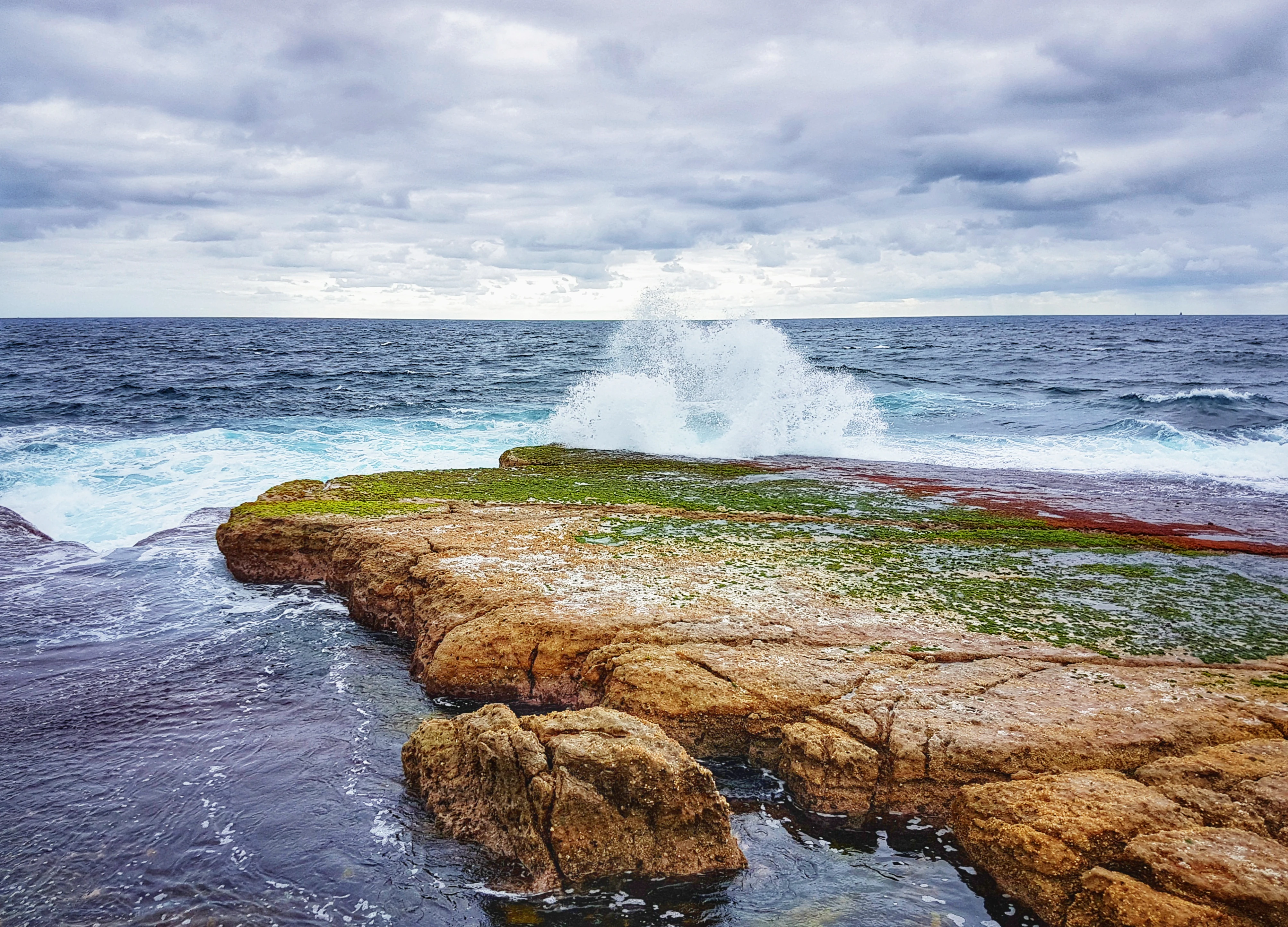
Ocean waves break against a flat, moss-covered rock formation extending into the sea under a cloudy sky.
Waves crashing over the flat rock platform at Moes Rock in Jervis Bay Marine Park.

Jervis Bay Marine Park history and protected-area timeline

The establishment of Jervis Bay Marine Park was a direct response to Australia's international and domestic conservation commitments in the 1990s. Australia ratified the United Nations Convention on Biological Diversity in late 1993, committing the country to develop strategies, plans, and protected areas aimed at conserving biodiversity and ensuring the sustainable use of biological resources. To help meet these obligations at the state level, the Government of New South Wales moved to establish a system of marine parks governed by zoning plans that balance ecological protection with human activity.

Jervis Bay Marine Park was formally created in 1998 under this framework. The initial zoning plan was subsequently revised, and the current zoning arrangement has been in place since 1 October 2002. Under this plan, different zones within the park allow or prohibit various activities, providing a structured approach to conserving marine habitats while permitting compatible recreational and commercial uses.

In May 2011, the New South Wales Government proposed a scientific audit to evaluate the effectiveness of the existing zones, citing concerns such as pollution, coastal development, and the risk of introduced pests and diseases. A more recently implemented zoning plan introduced in March 2011 was abolished the following day, and the long-standing 2002 zoning plan was restored pending the outcomes of the audit. This episode reflects the ongoing political and scientific attention given to balancing conservation outcomes with stakeholder interests in the management of the marine park.

Jervis Bay Marine Park landscape and geographic character

The physical setting of Jervis Bay Marine Park is defined by a long and varied southern New South Wales coastline. The park stretches over more than 100 kilometers from Kinghorn Point in the north to Sussex Inlet in the south, encompassing a mixture of broad sandy beaches, sheltered bays, tidal inlets, and rocky headlands. The nearshore waters over this span include both shallow, protected embayments and more exposed stretches where waves break against rock platforms and offshore features.

One of the more visually distinctive landscape elements in the park is Moes Rock, a rocky outcrop in the bay where waves regularly crash and break, creating a dramatic seascape characteristic of the park's more rugged sections. Along the broader coastline, alternating sections of dune-backed beaches, vegetated coastal cliffs, and low rocky shores give the area strong scenic variety. Inland edges of the marine park adjoin coastal communities and natural vegetation bordering the shore, linking the marine environment to the terrestrial landscape of the South Coast region.

The bay itself is renowned for the clarity of its water, contributing to the visual identity of the park and supporting its appeal for recreation. Combined, these coastal landforms and seascapes give Jervis Bay Marine Park a landscape that is as appealing for its scenery as it is important for its ecological role.

Jervis Bay Marine Park ecosystems, habitats, and plant life

Jervis Bay Marine Park encompasses a wide range of marine and coastal habitats along the New South Wales South Coast. Key ecological environments within the park include subtidal rocky reefs, kelp forests, seagrass meadows, sandy seafloor habitats, and intertidal rock platforms. These habitats differ significantly from one another in structure and species composition, and together form the ecological backbone of the reserve.

The sheltered waters of Jervis Bay support extensive seagrass beds that function as important nursery areas for fish and invertebrates, while the more exposed rocky reefs and kelp forests provide habitat for marine life adapted to stronger wave action and deeper water. Tidal inlets and estuarine influences, particularly toward the southern end of the park near Sussex Inlet, add salinity variation and nutrient-rich conditions that support distinct communities of plants and animals.

Above the waterline, the park's shoreline includes beach, dune, and heath environments that connect the marine ecosystems with the adjacent coastal vegetation. The combination of clear water, varied seabed types, and a long stretch of coastline allows the park to support a broad spectrum of marine biodiversity within a relatively compact geographic area.

Jervis Bay Marine Park wildlife and species highlights

The varied habitats of Jervis Bay Marine Park give it a rich and diverse marine fauna. The kelp forests, seagrass meadows, and rocky reefs support numerous fish species, including both resident reef fish and larger pelagic visitors that move through the bay. Invertebrates such as sea stars, urchins, mollusks, crustaceans, and various reef-building organisms are also part of the park's marine communities, contributing to the structure and function of the subtidal ecosystems.

The shoreline and nearshore environment provide feeding and resting areas for seabirds and shorebirds, while the location along a major migratory coastline adds to the seasonal importance of the area for birdlife. The mix of sheltered bays and exposed rocky shores creates microhabitats for different foraging and breeding behaviors, enhancing the park's wildlife value beyond its purely marine species.

Because the park covers a substantial length of coastline, it supports both species that depend on estuarine conditions and those that prefer open-coast habitats. This range of conditions contributes to the park's recognition as an important area for marine biodiversity in New South Wales.

Jervis Bay Marine Park conservation status and protection priorities

Jervis Bay Marine Park is an important component of New South Wales' system of marine protected areas, established primarily to conserve biological diversity in marine habitats while still permitting sustainable use. Its creation was driven by Australia's obligations under the United Nations Convention on Biological Diversity, which requires member states to protect ecosystems and natural habitats and to manage areas adjacent to protected areas in a sustainable way.

The park's zoning plan is the central tool for achieving its conservation goals. By regulating activities such as fishing, boating, and collecting, the zoning aims to reduce direct pressures on marine life while still allowing activities compatible with long-term ecological sustainability. Periodic reviews, including the scientific audit proposed in 2011, reflect an ongoing effort to ensure that the zoning is effective in addressing threats such as pollution, coastal development, and the potential introduction of pest species and diseases.

Beyond its immediate ecological role, the park contributes to broader marine conservation objectives in the region. Its proximity to populated coastal areas means it also serves an educational and awareness-raising function, helping connect residents and visitors with the marine environment and the need to protect it.

Jervis Bay Marine Park cultural meaning and human context

Jervis Bay has long been recognized as a place of strong coastal identity in New South Wales, with a history of fishing, boating, and beach-based recreation shaping the way local communities relate to the bay. The townships and villages that fringe the marine park, including Vincentia and other nearby settlements, have grown alongside the marine environment, and the protected area overlays a coast that has been used and appreciated by residents and visitors for generations.

The marine park also sits within a broader regional culture of outdoor recreation, where the ocean is central to local life through activities such as swimming, diving, sailing, and shoreline walking. This cultural attachment to the coast gives the marine park both a conservation mandate and a community-facing role, anchoring it in the everyday fabric of the South Coast region.

Top sights and standout views in Jervis Bay Marine Park

Jervis Bay Marine Park stands out for the combination of exceptionally clear coastal waters, a long and varied shoreline, and a thoughtful zoning-based approach to marine protection. Its scenic features, including the wave-battered Moes Rock and the broad white beaches along the bay, give it a strong visual identity, while its ecological assets, from kelp forests to seagrass meadows, make it a meaningful refuge for marine biodiversity.

Equally important is the park's role as a working example of how conservation and sustainable use can be integrated in a heavily visited coastal region. The ongoing review of its zoning, its connection to national conservation commitments, and its accessibility from populated coastal communities all reinforce its importance as a flagship marine reserve in New South Wales.

Best time to visit Jervis Bay Marine Park

Jervis Bay Marine Park can be visited year-round, but the experience varies with the seasons. Warmer months tend to bring calmer waters, extended daylight, and more active beach use, making them a popular time for swimming, snorkeling, and diving in the sheltered parts of the bay. Cooler months can bring more variable conditions and stronger swells, particularly along exposed sections of coast where wave action over rocky outcrops is more dramatic.

Wildlife and ecological viewing can shift through the year as different species are more visible in different seasons, and migratory seabirds and shorebirds may be present in greater numbers at certain times. Visitors interested in quieter conditions and sharper visibility for marine viewing often favor periods of calm, clear weather, while those drawn to the rugged wave-and-rock scenery of the park's more exposed features may appreciate the energy of rougher seas.


Monthly climate preview

Long term temperature and precipitation records measured across twelve distinct monthly intervals

Jervis Bay Marine Park Climate Normals and Annual Weather by Month

Jervis Bay Marine Park exhibits a measured annual temperature and precipitation rhythm derived from long term NASA Power climatology data. Examining the complete monthly climate normals reveals detailed seasonal fluctuations across representative regional coordinates.
Annual mean17 °C
12 °C22 °C
Jan22°
Feb22°
Mar20°
Apr18°
May15°
Jun13°
Jul12°
Aug12°
Sep15°
Oct17°
Nov19°
Dec21°
Warmest month
January

22.3 °C

Coolest month
July

11.7 °C

Wettest month
February

4.4 mm/day

Driest month
September

2 mm/day

Park location guide

Geography guide, regional context, and park location map for Jervis Bay Marine Park

Jervis Bay Marine Park park geography, regions, and map view in Australia

Understand where Jervis Bay Marine Park sits in Australia through a broader geographic reading of the surrounding landscape, nearby location context, and its mapped position within the national park landscape.

How Jervis Bay Marine Park fits into Australia

Australia is a constitutional monarchy and federal parliamentary democracy comprising six states and ten territories. With a population of nearly 28 million, it is one of the world's most urbanised countries, with most people concentrated on the eastern seaboard. The country has a high Human Development Index and is known for its cultural diversity, ancient Aboriginal heritage, and unique wildlife.

Wider geography shaping Jervis Bay Marine Park in Australia

Australia occupies the entire Australian continent, the island of Tasmania, and numerous smaller islands. It is the world's flattest and driest inhabited continent, featuring vast deserts in the interior (the Outback), tropical rainforests along the eastern coast, and a coastline bordering the Indian and Pacific Oceans.

Map view of Jervis Bay Marine Park

Use this park location map to pinpoint Jervis Bay Marine Park in Australia, understand its exact geographic position, and read its mapped placement within the surrounding landscape more clearly.

Pigeon | © OpenStreetMap contributors

Location context for Jervis Bay Marine Park

New South Wales

Visualizing protected coastal habitats, rocky headlands, and marine reserve landscapes

Jervis Bay Marine Park Photos and Coastal Scenery Explorer

Visual records capture the clear waters, rocky headlands, and submerged habitats defining Jervis Bay Marine Park along the southern New South Wales coast. Studying these protected coastal landscapes reveals the scenic variety and marine environments supported across the regional reserve.

Ocean waves break against a flat, moss-covered rock formation extending into the sea under a cloudy sky.

A wide, sandy beach with light-colored sand meets turquoise ocean waves under a clear blue sky, with a dense forest line on the right.

Park atlas

Compare adjacent regional reserves and connected marine landscapes along the southern coast.

Explore Other Parks Near Jervis Bay Marine Park And Surrounding Coastal Protected Areas

Visitors exploring Jervis Bay Marine Park can browse adjacent coastal reserves and protected marine habitats across the southern region. Expanding the geographic scope helps connect individual marine environments to broader coastal conservation networks.
National parkNew South Wales
About 4.4 km away#1 closest

North

Jervis Bay National Park: National Park Protected Landscape and Geographic Context

Explore New South Wales's protected natural terrain and mapped boundaries.

Jervis Bay National Park represents a distinct protected landscape within New South Wales, offering rich opportunities for geographic discovery. This entry details the park's specific location, its mapped natural terrain, and its significance as a protected national park. Understand its role in the regional geography and explore its boundaries through structured atlas information, providing a clear view of its environmental context.

Area
48.57 km²
Established
1995
IUCN
II
Relief
Lowland
National parkJervis Bay Territory
About 6.1 km away#2 closest

Southwest

Booderee National Park and Botanic Gardens: Australia's Protected Landscape Atlas Entry

Mapped geographic context within Jervis Bay Territory's national park.

Booderee National Park and Botanic Gardens is a key protected area in Australia, situated within the Jervis Bay Territory. This national park serves as a vital component of the region's geography, providing a clearly mapped landscape for atlas exploration. Understanding its specific protected-area boundaries and the surrounding natural terrain context is essential for a comprehensive geographic overview of this Australian conservation landscape.

Area
63.12 km²
Established
1992
IUCN
II
Relief
Lowland
National parkNew South Wales
About 18 km away#3 closest

Southwest

Conjola National Park: Mapped Protected Landscape within New South Wales Geography

Explore the park's protected boundaries and regional terrain.

Conjola National Park represents a distinct protected landscape within New South Wales, offering rich opportunities for geographic discovery. As a national park, its mapped boundaries and natural terrain contribute significantly to the regional atlas. This entry provides essential context for understanding the park's protected identity and its contribution to the broader geographic landscape of Australia, facilitating detailed map exploration.

Area
10 km²
Established
1994
IUCN
II
Relief
Lowland
National parkNew South Wales
About 19 km away#4 closest

West

Jerrawangala National Park: Protected Landscape Identity and New South Wales Geographic Context

Explore its mapped terrain and regional protected area distribution.

Jerrawangala National Park stands as a distinct protected natural area within the geography of New South Wales. This resource details its protected landscape character and its position within the broader regional atlas. Users can understand the park's mapped boundaries and its role in conservation landscapes, offering a concrete geographic anchor for exploration. Dive into the specifics of this national park's setting and its contribution to understanding the natural terrain of Australia.

Relief
Upland
Climate
Temperate
Access
Remote access
Scope
Terrestrial
Nature reserveNew South Wales
About 20 km away#5 closest

North

Comerong Island Nature Reserve: Mapped Protected Areas and Coastal Geography in New South Wales

Estuarine environments, mangrove forests, and coastal sandspits

Comerong Island Nature Reserve sits at the intersection of the Shoalhaven and Crookhaven Rivers and the Tasman Sea. This protected area offers a look at a compact, water-driven landscape dominated by mangrove ecosystems and shifting coastal sands. The geography serves as a case study in estuarine dynamics, illustrating how protected lands function where river mouths meet the open ocean along the coast of Australia.

Relief
Lowland
Climate
Temperate
Access
Easy access
Scope
Terrestrial
National parkNew South Wales
About 25 km away#6 closest

North

Seven Mile Beach National Park: New South Wales National Park, Coastal Delta & Bird Habitat Exploration

Explore the mapped terrain and protected landscapes of this significant Australian coastal park.

Seven Mile Beach National Park offers a fascinating case study in coastal geography and protected area management, situated within New South Wales, Australia. The park's landscape is defined by the Shoalhaven River delta, showcasing a unique environment of tidal flats, islands, and a substantial sand barrier. This ecosystem supports significant populations of migratory waders and seabirds, making it a noteworthy site for ornithological interest and broader conservation studies. Understanding this park's atlas representation reveals its distinct littoral rainforest and its role within the regional protected land network.

Area
8.981 km²
Established
1971
IUCN
II
Relief
Lowland
Watercolor landscape illustration showing green fields, trees, hills, and pastel sky
National parkNew South Wales
About 26 km away#7 closest

West

Morton National Park: A Protected Landscape of Waterfalls and Dissected Plateaus in New South Wales

Explore its mapped boundaries and regional geographic context.

Morton National Park is a nationally recognized protected area within New South Wales, Australia, celebrated for its striking natural features and geographic significance. The park's landscape is characterized by a dramatic dissected plateau, giving rise to impressive waterfall systems such as Fitzroy Falls and Belmore Falls that cascade into deep gorges. As a key component of the Southern Highlands' natural heritage, Morton National Park provides a rich subject for atlas exploration, offering insights into regional terrain, protected land distribution, and the unique interplay of natural elements within this Australian national park.

Area
1,997.45 km²
Established
1967
IUCN
II
Relief
Mixed relief
A soft watercolor illustration featuring sparse trees and low-lying scrubland against a hazy, distant horizon.
Nature reserveNew South Wales
About 32 km away#8 closest

Northwest

Cambewarra Range Nature Reserve: Geographic Atlas and Protected Landscape Overview

Escarpment forests and plateau terrain in New South Wales

The Cambewarra Range Nature Reserve acts as a resilient ecological anchor within the Southern Highlands, safeguarding coachwood-dominated rainforests and diverse heath shrublands. As part of a larger network of protected lands, its steep terrain and rocky cliffs provide essential habitat for threatened species while managing regional drainage across the Sydney Basin geological landscape.

Area
16.84 km²
Established
2001
Relief
Highland
Climate
Temperate

Common questions about visiting, size, designation, and location context for Jervis Bay Marine Park

Jervis Bay Marine Park FAQs for park facts, access, geography, and protected area context

Find quick answers about Jervis Bay Marine Park, including protected-area facts, park geography, trail and visitor context, and how the park fits into its surrounding country and regional landscape.
MoriAtlas Explorer

Continue Your Protected Areas Search Across the Global Atlas

Deepen your exploration by continuing the structured search for national parks and protected areas worldwide. Utilize the comprehensive filtering capabilities to compare different conservation landscapes and refine your understanding of global park geography. Discover more about the distribution and characteristics of protected natural areas.

Global natural geography