Mori Atlas logo
Wildlife reserveJimbilnan Wilderness

A detailed look at the topographic transitions from the Black Mountains toward Lake Mead

Jimbilnan Wilderness: Exploring the Rugged Desert Canyons and Protected Landscapes of Nevada

Jimbilnan Wilderness represents a vital protected area within the Mojave Desert of Nevada, encompassing over 18,000 acres of dramatic terrain. The landscape is defined by the eastern slopes of the Black Mountains, where steep, carved canyons transition into broad desert washes and gently sloping plateaus reaching the shoreline of Lake Mead. This unique topographic gradient supports rare desert botanical species and serves as an important ecological corridor for regional wildlife.

wilderness areaMojave DesertBlack MountainsLake Mead regiondesert canyonsdesert washes

Jimbilnan Wilderness

Wildlife reserve

Park overview

Structured park overview, official facts, and landscape profile for Jimbilnan Wilderness

Jimbilnan Wilderness park facts, protected area profile, and essential visitor context

Review the core facts for Jimbilnan Wilderness, including designation, size, terrain, visitor scale, habitats, and operating context in one park-focused overview.

About Jimbilnan Wilderness

Jimbilnan Wilderness occupies a transitional zone between the rugged Black Mountains of southern Nevada and the expansive shoreline of Lake Mead. Although relatively small compared to surrounding protected lands, the wilderness captures a representative slice of the eastern Mojave Desert's topographic diversity, from high, rocky canyon walls carved by flash floods and long-term erosion to lower, more gradual washes and benches that step down toward the lake. This gradient of elevation and substrate gives the area a layered ecological character that is more varied than its modest size might suggest.

Because it sits within the larger administrative landscape managed around Lake Mead, Jimbilnan contributes to a broader conservation strategy that protects both arid uplands and the shoreline, riparian, and aquatic environments of one of the most significant reservoirs in the American Southwest. Designated in 2002, the wilderness brings formal protection to a portion of the desert east of Las Vegas, where the surrounding region has otherwise experienced substantial development, recreation pressure, and water-management changes. The wilderness designation places the area in IUCN Category Ib, restricting road construction, motorized use, and other forms of development in order to preserve its wild character.

The wilderness is also notable for its biological richness relative to its footprint. The combination of rocky slopes, sandy washes, and proximity to Lake Mead supports plant communities adapted to both arid upland conditions and the slightly more mesic influence of the lake. Among the species drawing particular interest are Beaver Dam milkvetch and sticky buckwheat, both considered uncommon in this part of Nevada. Birdlife is similarly varied, with raptors such as the red-tailed hawk using the canyon's updrafts and songbirds such as the white-crowned sparrow occupying scrub and wash habitats, while bald eagles occasionally frequent the area in association with Lake Mead. Together, these qualities make Jimbilnan a valuable, if underappreciated, component of the desert conservation landscape that surrounds Las Vegas and Lake Mead.

Quick facts and research context for Jimbilnan Wilderness

Jimbilnan Wilderness is a federally designated wilderness area of about 18,879 acres located in the far eastern part of Clark County, Nevada. It lies between the Black Mountains on the west and Lake Mead on the east, roughly 40 miles east of Las Vegas, and is managed by the National Park Service as part of the surrounding Lake Mead region. The area was officially designated in 2002 and is classified as IUCN Category Ib, reflecting its wilderness-level protection status. It is bordered on its western side by Pinto Valley Wilderness Park, forming part of a connected network of desert wilderness tracts at the northern edge of the Mojave Desert.

Protection and recognition

Review documented terrestrial protection scope and international recognition status

Jimbilnan Wilderness Protection Status and Terrestrial Management Scope

Jimbilnan Wilderness maintains a documented terrestrial protection scope within the official protected area registry. Structured facts outline the recorded designation history and international recognition data for this landscape.

Protection details

Protection scope
Terrestrial
Transboundary protection
No
Park context

Deeper park guide and search-rich context for Jimbilnan Wilderness

Jimbilnan Wilderness history, landscape, wildlife, and travel context

Explore Jimbilnan Wilderness through its history, landscape character, ecosystems, wildlife, conservation priorities, cultural context, and seasonal travel timing in a structured park guide built for atlas discovery and search intent.

Why Jimbilnan Wilderness stands out

Jimbilnan Wilderness is best known for its compact but ecologically distinctive desert landscape, where steep Black Mountain canyons open eastward into broad washes and gently sloping plateaus that descend toward Lake Mead. Botanists and conservationists value the area for rare desert plants such as Beaver Dam milkvetch and sticky buckwheat, growing in a setting that also supports desert raptors and migratory songbirds. The wilderness also stands out as one of the smaller but ecologically meaningful units within the broader protective network surrounding Lake Mead, linking upland Mojave Desert habitat to the shoreline environments of a major western reservoir.

Jimbilnan Wilderness history and protected-area timeline

Jimbilnan Wilderness has a relatively recent history as a formally protected area. Its wilderness designation occurred in 2002, when it was added to the National Wilderness Preservation System as part of the broader late-twentieth and early-twenty-first century effort to safeguard representative desert landscapes around Lake Mead and the Black Mountains. Before this designation, the land was part of the public land mosaic managed within the larger Lake Mead region, where it supported a mix of grazing, recreation, and other low-intensity uses typical of the surrounding Mojave Desert.

The 2002 designation placed Jimbilnan under the management of the National Park Service, integrating it administratively with the surrounding Lake Mead National Recreation Area. The wilderness designation conferred the highest level of federal land protection short of full national park status, restricting road building, motorized access, and permanent infrastructure in order to preserve the area's natural character. The timing of the designation reflected a broader regional recognition of the ecological value of these desert canyons and washes, particularly as development pressure around Las Vegas continued to grow.

Since 2002, Jimbilnan has functioned primarily as a low-impact, lightly visited wilderness, managed in coordination with neighboring protected areas such as Pinto Valley Wilderness Park to the west. Its relatively short formal history means that most of its significance lies in its contemporary ecological and conservation role rather than in a deep record of human settlement or industrial use, although the broader region has long histories of Indigenous presence, mining, ranching, and water development around the Colorado River system.

Jimbilnan Wilderness landscape and geographic character

The landscape of Jimbilnan Wilderness is shaped by the eastern slopes of the Black Mountains, which rise abruptly on its western edge before descending through a network of canyons toward Lake Mead. These canyons, carved by flash floods and long-term erosion, form the dominant terrain feature of the area and give the wilderness much of its topographic drama. The rocky walls and narrow gullies contrast with the broader, flatter terrain that takes over as the mountains give way to the lower-elevation desert toward the east.

East of the canyon zone, three major washes spread out across the landscape, transitioning from confined channels into wide, sparsely vegetated plains. These washes act as natural corridors through the wilderness, channeling water and sediment during desert storms and creating softer, sandier terrain that contrasts with the rugged uplands. As the washes approach Lake Mead, the land levels further into gently sloping plateaus and benches that meet the shoreline zone, marking the eastern boundary of the protected area.

The interplay of mountains, canyons, washes, and plateaus within a relatively compact footprint gives Jimbilnan a notable diversity of scenery for a small wilderness. Hikers moving through the area may transition between steep, shadowy canyon walls; open, sun-baked wash bottoms dotted with scrub; and broad, quiet desert benches with expansive views toward the reservoir. The result is a landscape that feels larger and more varied than its acreage alone would suggest.

Jimbilnan Wilderness ecosystems, habitats, and plant life

Ecologically, Jimbilnan Wilderness reflects a typical eastern Mojave Desert environment, characterized by sparse vegetation, drought-adapted plant communities, and the influence of Lake Mead on the local microclimate along the eastern edge of the area. The combination of rocky uplands, sandy washes, and shoreline-influenced benches supports a mosaic of plant associations, ranging from typical desert scrub species on the slopes to somewhat more mesic assemblages in areas closer to the lake. This layering of habitats contributes to the area's biological diversity.

The wilderness is particularly noted for the presence of several rare or uncommon plant species. Among the most frequently highlighted are the Beaver Dam milkvetch, a milkvetch species with a restricted distribution in this part of the Mojave, and the sticky buckwheat, another locally significant desert plant. Their presence gives Jimbilnan botanical importance well beyond what its size might imply, marking it as a meaningful site for plant conservation in the region.

Beyond its plant communities, the area's ecological character is shaped by the transition from mountain desert to the lacustrine influence of Lake Mead. This interface introduces gradients of moisture, soil, and exposure that support wildlife communities more varied than would be expected in a strictly upland desert. The result is a small but ecologically rich wilderness whose habitats bridge the arid mountains to the west and the reservoir-influenced terrain to the east.

Jimbilnan Wilderness wildlife and species highlights

Wildlife in Jimbilnan Wilderness is shaped by the area's position between the Black Mountains and Lake Mead, which together provide a mix of upland desert habitats and shoreline-influenced environments. Raptors are among the most visible animal inhabitants, taking advantage of the thermal updrafts along the canyon walls and the open vistas above the washes. Red-tailed hawks are regularly associated with the area, soaring above the slopes and hunting across the desert below.

Songbirds and other smaller bird species also occupy the wilderness in noticeable numbers. The white-crowned sparrow, a familiar North American songbird, is among the species recorded in the area, often found in scrubby wash and slope habitats. The proximity to Lake Mead adds a lacustrine and riparian dimension to the birdlife, drawing waterbirds and birds of prey associated with open water and shoreline habitats. Bald eagles have been documented in association with the area, reflecting the broader importance of the Lake Mead region for large raptors and migratory species.

Beyond birds, the canyons and washes of Jimbilnan provide habitat for the typical suite of Mojave Desert fauna, including small mammals, reptiles, and invertebrates adapted to arid conditions. Although the source material emphasizes the area's birdlife and rare plants, the broader ecological fabric of the wilderness includes the desert fauna characteristic of the eastern Mojave, contributing to a wildlife community that benefits from the protection afforded by wilderness designation.

Jimbilnan Wilderness conservation status and protection priorities

Jimbilnan Wilderness plays a meaningful role in the conservation network surrounding Lake Mead and the Black Mountains, even though it is one of the smaller designated wildernesses in the region. Its 2002 designation added a new layer of formal protection to a corridor of desert landscape that had otherwise been exposed to growing pressures from urban expansion, recreation, and infrastructure development associated with the rapid growth of the Las Vegas area. Under IUCN Category Ib wilderness protection, the area is shielded from road construction, motorized access, and most forms of permanent development, preserving its natural conditions over the long term.

The wilderness also contributes to regional biodiversity conservation through its protection of rare plant habitat. The documented presence of uncommon species such as Beaver Dam milkvetch and sticky buckwheat gives Jimbilnan botanical conservation value that extends beyond its acreage, providing a refuge for desert plants whose broader populations are limited. By keeping these habitats intact within a managed wilderness framework, the area helps safeguard plant diversity in a region where desert ecosystems face ongoing pressures.

In a broader sense, Jimbilnan functions as part of an interconnected conservation landscape that includes the neighboring Pinto Valley Wilderness Park, the Black Mountains, and Lake Mead itself. Together, these protected areas maintain ecological connectivity across the eastern Mojave, supporting wildlife movement, watershed function, and the long-term resilience of desert ecosystems in one of the fastest-growing metropolitan regions of the American Southwest.

Jimbilnan Wilderness cultural meaning and human context

The cultural context of Jimbilnan Wilderness is closely tied to the broader human history of the Mojave Desert and the Lake Mead region. Long before its formal protection, the broader landscape supported Indigenous presence, ranching, mining, and the early-twentieth-century development of water resources along the Colorado River system. The construction and operation of Lake Mead, in particular, fundamentally reshaped the regional geography and economy, drawing recreational use, infrastructure, and population growth to an otherwise arid region.

For the Las Vegas area, the desert lands east of the city, including the Black Mountains and the canyons draining toward Lake Mead, have represented both a recreational backyard and a buffer of relatively undeveloped terrain. The 2002 designation of Jimbilnan reflects a regional effort to retain portions of this landscape in a wild condition, even as the surrounding metropolitan area expanded. While the wilderness itself does not contain prominent cultural sites in the documented record, its protection represents a deliberate cultural choice to preserve natural desert character in close proximity to one of the fastest-growing cities in the United States.

Top sights and standout views in Jimbilnan Wilderness

Jimbilnan Wilderness packs a remarkable range of features into a relatively small protected footprint, making it a notable component of the desert conservation landscape east of Las Vegas. Its most distinctive highlights include the transition from steep Black Mountain canyons to broad desert washes and gently sloping plateaus approaching Lake Mead, a topographic variety that gives the area an outsized sense of space and diversity.

Equally important is the botanical significance of the wilderness, anchored by the presence of rare species such as Beaver Dam milkvetch and sticky buckwheat. Combined with documented birdlife ranging from red-tailed hawks and white-crowned sparrows to bald eagles, these features make Jimbilnan a quietly valuable refuge of Mojave Desert biodiversity, connected to neighboring protections such as Pinto Valley Wilderness Park and the broader Lake Mead landscape.

Best time to visit Jimbilnan Wilderness

Jimbilnan Wilderness, like much of the eastern Mojave Desert, is best experienced during the cooler months of late fall, winter, and early spring, when daytime temperatures are more moderate and the desert environment is more comfortable for hiking and exploration. Winter and early spring visits often bring mild daytime conditions and crisp, clear nights, while also offering seasonal flowering and germination events in the washes and benches that can make desert flora more visible, including the rare plants for which the area is known.

Late spring and summer tend to bring intense heat to this part of Nevada, with high desert temperatures that make extended hiking difficult and potentially dangerous. Visitors during this period typically limit activity to short, early-morning or evening excursions. Birdlife, including raptors and migratory songbirds, can be active around the canyons and shoreline-influenced benches across much of the year, while cooler months also tend to coincide with broader patterns of raptor and waterbird presence associated with Lake Mead. For visitors seeking both comfortable conditions and an active natural landscape, the cooler half of the year generally offers the most rewarding experience of the wilderness.
Monthly climate preview

Long-term temperature ranges and precipitation averages for Nevada terrain

Jimbilnan Wilderness Climate Normals and Monthly Weather Patterns

Jimbilnan Wilderness exhibits a measured annual cycle of monthly temperatures and precipitation records based on representative coordinate data from 1991 to 2020. Examining the complete twelve-month climate profile reveals detailed patterns across daily minimum and maximum temperature distributions.
Annual mean20 °C
7 °C33 °C
Jan
Feb10°
Mar14°
Apr18°
May24°
Jun30°
Jul33°
Aug32°
Sep28°
Oct20°
Nov12°
Dec
Warmest month
July

33 °C

Coolest month
December

7 °C

Wettest month
February

1 mm/day

Driest month
June

0.1 mm/day

Park location guide

Geography guide, regional context, and park location map for Jimbilnan Wilderness

Jimbilnan Wilderness park geography, regions, and map view in United States of America

Understand where Jimbilnan Wilderness sits in United States of America through a broader geographic reading of the surrounding landscape, nearby location context, and its mapped position within the national park landscape.

How Jimbilnan Wilderness fits into United States of America

The United States of America is a federal presidential republic and one of the world's largest countries by area and population. It consists of 50 states across a vast territory spanning multiple time zones, with its capital in Washington, D.C. and largest city in New York City. The nation has a diverse economy, influential political system, and significant cultural and military presence globally.

Wider geography shaping Jimbilnan Wilderness in United States of America

The United States occupies a vast territory in North America, bordered by Canada to the north and Mexico to the south. The 48 contiguous states stretch from the Atlantic to the Pacific Ocean, while Alaska occupies the northwestern region and Hawaii is an archipelago in the Pacific. The country encompasses diverse terrain including the Rocky Mountains, Appalachian Mountains, Great Plains, and extensive river systems.

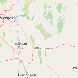
Map view of Jimbilnan Wilderness

Use this park location map to pinpoint Jimbilnan Wilderness in United States of America, understand its exact geographic position, and read its mapped placement within the surrounding landscape more clearly.

Pigeon | © OpenStreetMap contributors

Location context for Jimbilnan Wilderness

Nevada
Park atlas

Compare surrounding Mojave Desert landscapes and connected conservation units.

Parks Near Jimbilnan Wilderness and Related Protected Areas in the Region

Browsing other protected areas near Jimbilnan Wilderness reveals shared desert canyon terrain and regional wildlife corridors. Examining adjacent Nevada wilderness units helps place compact desert habitats within a broader geographical context.
A watercolor painting showing a soft-toned landscape with a winding river in the foreground, a forested middle ground, and rolling mountains in the distance.
Protected landscapeUnited States of America
About 0.5 km away#1 closest

East

Lake Mead National Recreation Area: Desert Reservoir and Protected Landscape Atlas

United States protected geography and reservoir terrain

Spanning the lower Colorado River, Lake Mead National Recreation Area represents a unique convergence of desert ecosystems and large-scale water management. Its geography includes extensive reservoir shorelines, deep canyon corridors, and volcanic basin terrain that provide a foundational look at the arid environments of the American Southwest. The area remains a significant study of how engineered water features alter and interact with complex desert landscapes.

Area
6,053.31 km²
Established
1936
IUCN
V
Visitors
6.4M annual
A horizontal watercolor painting depicting soft desert hills in shades of green, yellow, and soft pink.
Wildlife reserveClark County
About 35 km away#2 closest

North

Muddy Mountains Wilderness: Geographic Atlas and Protected Desert Landscape Map

Exploration of sandstone terrain and Clark County topography.

Navigate the complex desert geography of the Muddy Mountains Wilderness, a protected area characterized by its vivid red cliffs, ancient cross-bedded sandstone, and steep elevation gains. This atlas entry provides essential context on the wilderness boundaries, regional landscape patterns, and environmental features that define this significant Mojave Desert refuge.

Area
194.87 km²
Established
2002
Relief
Mountain
Water
Minor water
Wildlife reserveNevada
About 46 km away#3 closest

South

Ireteba Peaks Wilderness: Protected Desert Mountains and Lake Mohave Reservoir Shoreline

Mapping the Eldorado Mountains within southern Nevada desert protected areas.

Spanning the southern Eldorado Mountains and the northern shores of Lake Mohave, Ireteba Peaks Wilderness represents a critical Mojave Desert protected area. This landscape integrates rugged, rocky ridgelines with arid desert slopes and reservoir inlets. Its geographic character, shaped by both federal wilderness designation and proximity to the Avi Kwa Ame National Monument, preserves a vital slice of Nevada desert terrain and native ecological habitat.

Area
132.51 km²
Established
2002
IUCN
Ib
Relief
Mountain
A watercolor painting showing soft green hills, distant pink-hued mountains, and a pale blue lake in a serene, stylized landscape.
Protected landscapeNevada
About 53 km away#4 closest

Northwest

Humboldt, Toiyabe National Forest: Protected Landscape and Regional Mountain Geography

A vast network of Nevada mountain ranges and alpine wilderness

Humboldt, Toiyabe National Forest serves as a defining public land entity across Nevada and eastern California. As the largest national forest in the contiguous United States, it preserves a striking collection of isolated mountain ranges, including the Ruby Mountains and the rugged Jarbidge wilderness, within a broader basin-and-range landscape. Examine the boundaries and terrain that characterize this complex, high-desert ecosystem.

Area
25,454 km²
Established
1908
Relief
Mountain
Access
Easy access
Watercolor painting of green rolling hills and distant purple mountains with a small waterfall flowing into a body of water in the foreground.
Protected landscapeNevada
About 53 km away#5 closest

West

Spring Mountains National Recreation Area: Alpine Geography and Protected Mountain Landscapes

A rugged mountain anchor in the southern Nevada desert

Rising sharply from the desert floor, Spring Mountains National Recreation Area features dramatic elevation shifts across 316,000 acres of forested canyons and rocky ridges. This protected landscape preserves vital mountain habitat and diverse terrain, ranging from pinyon-juniper woodlands to high-alpine environments near Mount Charleston, serving as a distinct natural contrast to the Mojave surroundings.

Area
1,280 km²
Established
1993
IUCN
V
Relief
Mountain
Wildlife reserveClark County
About 65 km away#6 closest

East

Jumbo Springs Wilderness: Geographic Profile and Protected Landscape Atlas

A rugged desert preserve in Clark County, Nevada

Jumbo Springs Wilderness preserves a dense concentration of desert geology within a compact footprint. Users can analyze the protected boundaries, which feature Precambrian metamorphic formations and granitic domes that rise above arid drainages. This area functions as a critical desert refuge near the Lake Mead reservoir, providing a distinct look at the transition between rocky mountain slopes and water-influenced desert microhabitats.

Area
18.74 km²
Established
2002
IUCN
Ib
Relief
Upland
Watercolor painting showing stylized green mountains, pine trees, and soft yellow and purple tones in the landscape.
Wildlife reserveNevada
About 70 km away#7 closest

Northwest

Mount Charleston Wilderness: Protected Mountain Geography and Spring Mountains Atlas

High-altitude wilderness and ancient forest landscapes in southern Nevada

Spanning the crest of the Spring Mountains, Mount Charleston Wilderness stands as a protected natural landmark in Nevada. This area offers an atlas-focused view of subalpine ridges, ancient bristlecone pine forests, and steep fault-block terrain that contrast significantly with the arid Mojave Desert basins located below.

Area
232.46 km²
Established
1989
IUCN
Ib
Relief
Mountain
National parkArizona
About 79 km away#8 closest

East

Grand Canyon National Park: Arizona National Park Protected Landscape & Geography

Explore mapped boundaries and regional atlas context.

Grand Canyon National Park stands as a premier national park, showcasing a unique protected landscape within Arizona's diverse geography. This detailed entry focuses on the park's specific geographic identity, its mapped boundaries, and its significance within the regional atlas. Discover the contours of this protected area and its place in the natural terrain of the American Southwest.

Area
4,926.08 km²
Established
1919
IUCN
II
Visitors
4.9M annual

Common questions about visiting, size, designation, and location context for Jimbilnan Wilderness

Jimbilnan Wilderness FAQs for park facts, access, geography, and protected area context

Find quick answers about Jimbilnan Wilderness, including protected-area facts, park geography, trail and visitor context, and how the park fits into its surrounding country and regional landscape.
MoriAtlas Explorer

Continue Your Protected Areas Search Across the Global Atlas

Deepen your exploration by continuing the structured search for national parks and protected areas worldwide. Utilize the comprehensive filtering capabilities to compare different conservation landscapes and refine your understanding of global park geography. Discover more about the distribution and characteristics of protected natural areas.

Global natural geography