
Mori Atlas logo
Wildlife reserveJoyce Kilmer-Slickrock Wilderness

Mapping the protected watersheds and ancient cove hardwood ecosystems of the Unicoi Mountains

Joyce Kilmer-Slickrock Wilderness: A Geographic Atlas of Appalachian Old-Growth Forest Landscapes

Joyce Kilmer-Slickrock Wilderness protects a significant expanse of the southern Appalachian Mountains, featuring deep creek valleys and rare old-growth forest stands. This atlas provides a detailed look at the protected topography, ranging from the towering tulip poplars of the Joyce Kilmer Memorial Forest to the high-elevation grassy balds at Bob Stratton Bald. Discover the complex network of stream corridors and mountain ridges that define this preserved wilderness.

wilderness areaold-growth forestAppalachian cove hardwoodstulip poplarnational forestsouthern Appalachians
A digital illustration of a mountainous valley landscape with a river in the foreground, coniferous trees, and tall granite cliffs including a waterfall in the background.

Joyce Kilmer-Slickrock Wilderness

Wildlife reserve

Park overview

Structured park overview, official facts, and landscape profile for Joyce Kilmer-Slickrock Wilderness

Joyce Kilmer-Slickrock Wilderness park facts, protected area profile, and essential visitor context

Review the core facts for Joyce Kilmer-Slickrock Wilderness, including designation, size, terrain, visitor scale, habitats, and operating context in one park-focused overview.

About Joyce Kilmer-Slickrock Wilderness

Joyce Kilmer-Slickrock Wilderness sits at the heart of the southern Blue Ridge, where the Nantahala and Cherokee National Forests meet along the North Carolina and Tennessee border. The wilderness occupies the upper watersheds of Slickrock Creek and Little Santeetlah Creek, two mountain streams that rise on opposite slopes of Bob Stratton Bald and ultimately drain into the Little Tennessee River. Tapoco is the nearest community, and the roads that reach the area trace the routes once used by early twentieth-century logging operations.

At a landscape scale, the wilderness is a study in the geography of the southern Appalachians: steep ridges, deeply incised creek valleys, and high grassy balds typical of the Unicoi Mountains. Bob Stratton Bald and adjoining summits give the area its open, meadow-like skylines, while the lower slopes drop into shaded, moisture-rich coves that support extraordinarily diverse forest communities. This vertical range, from creek bottoms to grassy peaks, is central to the wilderness's ecological identity.

Ecologically, Joyce Kilmer-Slickrock is significant for the extent and quality of its old-growth forest. The Joyce Kilmer Memorial Forest along Little Santeetlah Creek is a classic Appalachian cove hardwood community, dominated by tulip poplar, eastern hemlock, red and white oak, American basswood, American beech, and American sycamore. Together with additional old-growth stands in the Slickrock Creek basin, the wilderness contains one of the largest continuous blocks of old forest in the Eastern United States, surrounded largely by mature second-growth forest that has regrown after decades of selective logging.

The wilderness matters not only for what grows within it but also for its place within a larger protected landscape. It adjoins the Citico Creek Wilderness to the south, forming an expansive, low-impact forest block that supports wide-ranging wildlife and protects the headwaters of streams that have shaped both the natural and human history of the region. For visitors, researchers, and conservationists, Joyce Kilmer-Slickrock stands as a defining reference point for what an eastern temperate forest can look like when allowed to function across centuries at full scale.

Quick facts and research context for Joyce Kilmer-Slickrock Wilderness

Joyce Kilmer-Slickrock Wilderness was established by the U.S. Forest Service in 1975 and protects roughly 17,000 to 19,000 acres within the Nantahala National Forest in North Carolina and the Cherokee National Forest in Tennessee. It is classified as an IUCN Category Ib wilderness area, meaning the land is managed to preserve its natural character without significant human intervention.

Its core conservation feature is the Joyce Kilmer Memorial Forest, a 3,800-acre tract of old-growth cove hardwood forest along Little Santeetlah Creek, dedicated in 1936 as a living memorial to poet Joyce Kilmer. The wider wilderness includes about 5,926 acres of old growth, making it one of the largest such tracts in the eastern United States. Tapoco, in North Carolina, is the nearest community, and the wilderness adjoins the Citico Creek Wilderness to the south.

Protection and recognition

Examine documented terrestrial protection metrics and transboundary scope

Joyce Kilmer-Slickrock Wilderness Protection Status and Recognition

Terrestrial protection status for Joyce Kilmer-Slickrock Wilderness outlines management scope and transboundary boundaries. Official conservation records capture framework details without supplemental international recognition sources.

Protection details

Protection scope
Terrestrial
Transboundary protection
Yes
Park context

Deeper park guide and search-rich context for Joyce Kilmer-Slickrock Wilderness

Joyce Kilmer-Slickrock Wilderness history, landscape, wildlife, and travel context

Explore Joyce Kilmer-Slickrock Wilderness through its history, landscape character, ecosystems, wildlife, conservation priorities, cultural context, and seasonal travel timing in a structured park guide built for atlas discovery and search intent.

Why Joyce Kilmer-Slickrock Wilderness stands out

Joyce Kilmer-Slickrock is best known for the sheer scale and age of its old-growth Appalachian forest, particularly the towering tulip poplars of the Joyce Kilmer Memorial Forest, some of which exceed 100 feet in height, 20 feet in circumference, and 400 years in age. The grove is widely regarded as one of the most awe-inspiring examples of unlogged cove hardwood forest in the Eastern United States. Equally defining is the wilderness's broader ecological character: tightly nested creek valleys climbing into the Unicoi Mountains, classic Appalachian grassy balds such as Bob Stratton Bald, and a continuous forest matrix that has endured largely unbroken since the early twentieth century. The area's combination of biological richness, ecological continuity, and scenic integrity makes it a benchmark site for eastern forest conservation.
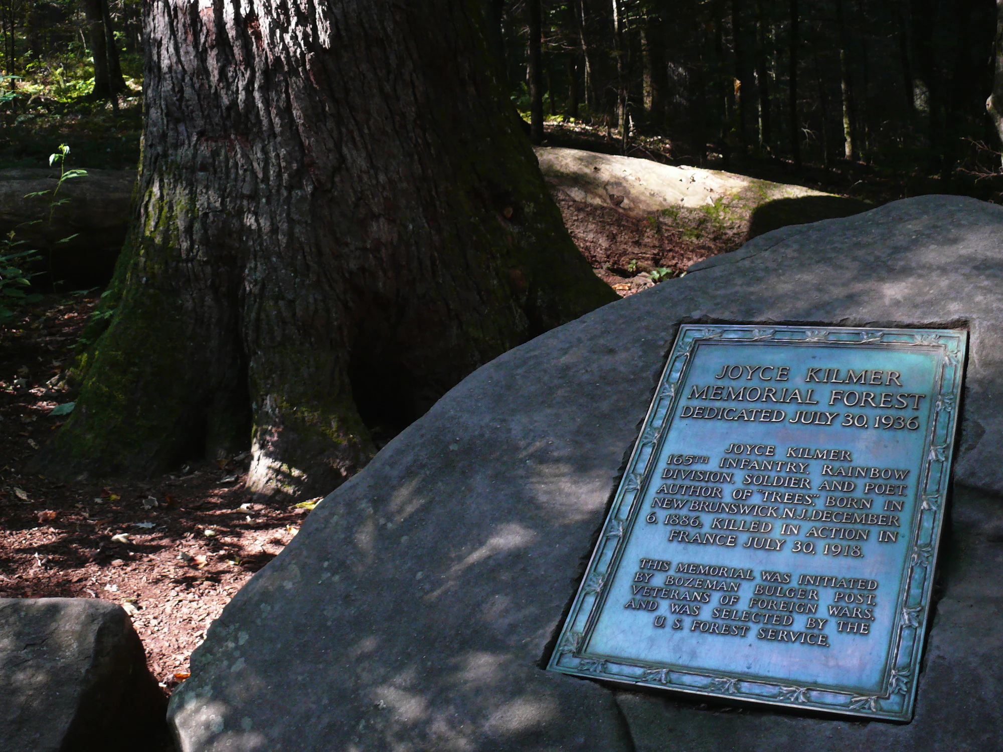
A bronze memorial plaque for Joyce Kilmer Memorial Forest, mounted on a large rock in a shaded forest setting.
The memorial plaque dedicated to Joyce Kilmer at the entrance to the Joyce Kilmer Memorial Forest.

Joyce Kilmer-Slickrock Wilderness history and protected-area timeline

The modern history of Joyce Kilmer-Slickrock Wilderness begins in the early twentieth century, when the forests of the Slickrock Creek watershed were intensively worked by the Babcock Lumber Company. By the time operations ended, roughly two-thirds of the watershed had been logged. The completion of Calderwood Dam in 1922 flooded the company's railroad grade, cutting off access to the remaining timber and effectively halting further cutting in the area, an unintentional but pivotal moment for the future of the forest.

In the 1930s, the Veterans of Foreign Wars approached the U.S. Forest Service with a proposal to create a living memorial to Joyce Kilmer, an American poet and journalist who was killed in World War I and whose poem Trees became a popular expression of reverence for the natural world. After evaluating millions of acres, the Forest Service selected an undisturbed 3,800-acre tract along Little Santeetlah Creek. In 1936, this tract was formally dedicated as the Joyce Kilmer Memorial Forest, anchoring the broader area in the public imagination as a place set aside in a poet's name.

The surrounding landscape and the Joyce Kilmer Memorial Forest were subsequently shielded from development and large-scale exploitation as part of the national forest system. In 1975, Congress designated the expanded Joyce Kilmer-Slickrock Wilderness, formalizing protection of the old-growth groves, the Slickrock and Little Santeetlah watersheds, and the high-country ridges and balds that connect them. The designation placed the area under the strict management standards of the National Wilderness Preservation System, a status it continues to hold under the U.S. Forest Service.

Joyce Kilmer-Slickrock Wilderness landscape and geographic character

Joyce Kilmer-Slickrock Wilderness is shaped by the parallel valleys of Slickrock Creek and Little Santeetlah Creek, which carve deep, narrow gorges into the Unicoi Mountains. The terrain alternates between steep, forested slopes and more open, gently rounded ridgelines, with elevation changing rapidly as streams descend toward the Little Tennessee River. This valley-and-ridge pattern is characteristic of the southern Blue Ridge and gives the wilderness much of its topographic drama.

Among the most striking landscape features are the grassy balds that crown the higher elevations. Bob Stratton Bald, a roughly 5,360-foot open summit at the southwestern corner of the wilderness, is the symbolic high point of the area. From its meadows, the eye takes in both the Slickrock and Little Santeetlah valleys below, and the slopes of Stratton Bald are the literal headwaters of both creeks. Such treeless summits are a signature Appalachian feature, and their presence here adds open, far-reaching vistas unusual within an otherwise densely forested wilderness.

The lower elevations of the wilderness are anchored by the cove along Little Santeetlah Creek, where deep soils, persistent moisture, and protection from wind have allowed trees to grow to extraordinary dimensions. Slickrock Creek's basin shows a mix of older forest along its upper slopes and younger regrowth lower down, reflecting the area's logging history. Throughout the wilderness, exposed rock outcrops, cascading tributaries, and quiet, shaded stream corridors create a landscape that feels both remote and intricately textured.

Joyce Kilmer-Slickrock Wilderness ecosystems, habitats, and plant life

The ecological identity of Joyce Kilmer-Slickrock Wilderness is defined by one of the largest blocks of old-growth forest remaining in the Eastern United States. The Joyce Kilmer Memorial Forest along Little Santeetlah Creek is an extraordinary example of an Appalachian cove hardwood forest, a forest type unique to the southern mountains and notable for both its species richness and its scale. Covelike sites such as this are typically the most biologically productive and diverse communities in the Appalachian forest system.

Beyond the memorial grove, the wider wilderness includes substantial old growth in the upper watershed of Slickrock Creek, with the balance of the area made up of mature second-growth forest that has been recovering from early twentieth-century logging for many decades. This combination of true old growth alongside late-successional regrowth provides a rare, multi-aged forest landscape in a region where extensive unlogged forest is exceptional.

The mix of habitats here is unusually broad: shaded cove forests, rocky slopes, stream corridors, high-elevation balds, and exposed ridgelines each support different plant and animal communities. The resulting ecological mosaic contributes to the wilderness's outstanding conservation value and to its importance as a living laboratory for understanding eastern forest dynamics.

Joyce Kilmer-Slickrock Wilderness wildlife and species highlights

The wildlife of Joyce Kilmer-Slickrock Wilderness reflects the quality and continuity of its forest cover. The combination of old-growth stands, mature second-growth forest, cool, shaded streams, and open high-elevation balds supports a rich community of Appalachian forest species. Salamanders, native fish, and aquatic invertebrates thrive in the cool, undisturbed waters of Slickrock Creek and Little Santeetlah Creek, while the forest itself provides habitat for black bear, white-tailed deer, wild turkey, and numerous songbird species typical of mature eastern hardwood forest.

The wilderness and its adjoining Citico Creek Wilderness form a particularly significant landscape for wide-ranging and disturbance-sensitive species, including neotropical migrant birds and other animals that depend on large, unbroken forest tracts. The presence of centuries-old trees, many of them well over 400 years old, also creates important nesting cavities and microhabitats that are absent from younger forests.

Because the wilderness is managed to maintain its wilderness character, wildlife here is shaped by minimal human disturbance, natural disturbance regimes, and the slow ecological processes that govern mature forest communities. This gives the area substantial value for both conservation and ecological research on the central and southern Appalachian ecosystems.

Joyce Kilmer-Slickrock Wilderness conservation status and protection priorities

Joyce Kilmer-Slickrock Wilderness is one of the most important conservation sites in the Eastern United States for the protection of old-growth temperate forest. With approximately 5,926 acres of old growth, a substantial portion of it within the Joyce Kilmer Memorial Forest, the wilderness preserves an ecological resource that has largely vanished from the eastern landscape. Old growth of this scale is exceedingly rare east of the Mississippi River, and the area is therefore a benchmark for understanding what eastern temperate forests can become when allowed to develop without large-scale human intervention.

The wilderness was formally protected in 1975 under the National Wilderness Preservation System, joining a select group of eastern landscapes recognized for their outstanding ecological, scenic, and historical values. Its IUCN Category Ib designation reflects its status as a place managed primarily to safeguard its natural character and ecological processes, with strongly limited infrastructure and development.

The protection also carries historical and cultural weight: the original Joyce Kilmer Memorial Forest was set aside in 1936 as a tribute to a poet whose work celebrated trees and the natural world. Designating the wider landscape as wilderness more than three decades later extended that early conservation gesture into a comprehensive framework for protecting the full watershed. The result is a landscape that links ecological preservation, forest history, and literary heritage across more than a century of evolving conservation practice.

Joyce Kilmer-Slickrock Wilderness cultural meaning and human context

The cultural identity of Joyce Kilmer-Slickrock Wilderness is closely tied to the memory of Joyce Kilmer, the American poet and journalist best known for his poem Trees. Killed in World War I, Kilmer became a powerful symbol of reverence for nature, and the 1936 dedication of the Joyce Kilmer Memorial Forest by the Veterans of Foreign Wars and the U.S. Forest Service was a deliberate effort to translate that reverence into an enduring, place-based tribute.

The wilderness also reflects longer histories of land use in the southern Appalachians, including the early commercial logging era that shaped the watershed before Calderwood Dam silenced the saws. The contrast between heavily cut slopes and the surviving old-growth stands gives the area a layered cultural and ecological narrative, in which a working forest landscape transitioned first into a memorial grove and then into a fully protected wilderness.

Top sights and standout views in Joyce Kilmer-Slickrock Wilderness

Joyce Kilmer-Slickrock Wilderness is defined by the scale of its ancient trees, the rarity of its eastern old-growth forest, and the integrity of its watersheds. The tulip poplar grove at the heart of the Joyce Kilmer Memorial Forest, with individual trees exceeding 100 feet tall and 400 years old, offers a visceral sense of what eastern temperate forests looked like before widespread logging.

Its high country adds another dimension: the open, sweeping views from Bob Stratton Bald, the convergence of two creek systems in a single wilderness, and a continuous forest connection into the adjoining Citico Creek Wilderness. Together, these qualities make the area both a premier destination for those drawn to old-growth forest experiences and a reference site for the broader story of forest conservation in the eastern United States.

Best time to visit Joyce Kilmer-Slickrock Wilderness

Spring and fall are widely regarded as the most rewarding seasons to experience Joyce Kilmer-Slickrock Wilderness. In spring, blooming understory plants and fresh leaf-out bring vivid color to the cove forests and make the scale of the tulip poplars especially striking, while mild temperatures are favorable for the steep, often strenuous trails that descend into the creek valleys.

Fall delivers the most dramatic color display in the hardwood canopy, when the mix of tulip poplar, oak, hickory, sourwood, and other species turns the ridgelines into layered palettes of red, orange, and gold. The open balds, including Bob Stratton Bald, provide wide views over this autumn canopy, an experience quite different from the enclosed forest walks in the lower creek valleys.

Summer can be warm and humid, especially at lower elevations where the forest canopy is dense and breezes are limited; winter brings cooler temperatures and occasional snow, and while trails can be more difficult due to ice and shorter daylight hours, the bare-season forest showcases the structure of the old trees in a way no other season does.

Monthly climate preview

Long-term representative point measurements tracking annual temperature and precipitation rhythms

Joyce Kilmer-Slickrock Wilderness Climate Normals and Weather by Month

Representative coordinate records show measured monthly temperature variation alongside consistent precipitation patterns across the protected landscape. Examining the complete twelve-month climatology reveals full baseline extremes for long-term terrain analysis.
Annual mean13 °C
2 °C23 °C
Jan
Feb
Mar
Apr12°
May17°
Jun21°
Jul23°
Aug23°
Sep19°
Oct13°
Nov
Dec
Warmest month
July

23 °C

Coolest month
January

1.6 °C

Wettest month
February

4.4 mm/day

Driest month
October

2.7 mm/day

Park location guide

Geography guide, regional context, and park location map for Joyce Kilmer-Slickrock Wilderness

Joyce Kilmer-Slickrock Wilderness park geography, regions, and map view in United States of America

Understand where Joyce Kilmer-Slickrock Wilderness sits in United States of America through a broader geographic reading of the surrounding landscape, nearby location context, and its mapped position within the national park landscape.

How Joyce Kilmer-Slickrock Wilderness fits into United States of America

The United States of America is a federal presidential republic and one of the world's largest countries by area and population. It consists of 50 states across a vast territory spanning multiple time zones, with its capital in Washington, D.C. and largest city in New York City. The nation has a diverse economy, influential political system, and significant cultural and military presence globally.

Wider geography shaping Joyce Kilmer-Slickrock Wilderness in United States of America

The United States occupies a vast territory in North America, bordered by Canada to the north and Mexico to the south. The 48 contiguous states stretch from the Atlantic to the Pacific Ocean, while Alaska occupies the northwestern region and Hawaii is an archipelago in the Pacific. The country encompasses diverse terrain including the Rocky Mountains, Appalachian Mountains, Great Plains, and extensive river systems.

Map view of Joyce Kilmer-Slickrock Wilderness

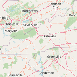
Use this park location map to pinpoint Joyce Kilmer-Slickrock Wilderness in United States of America, understand its exact geographic position, and read its mapped placement within the surrounding landscape more clearly.

Pigeon | © OpenStreetMap contributors

Location context for Joyce Kilmer-Slickrock Wilderness

North CarolinaTennessee
Recorded earthquake history

Browse the Historical Earthquake Catalogue for Joyce Kilmer-Slickrock Wilderness

Examine the recorded history of seismic events in the vicinity of the Joyce Kilmer-Slickrock Wilderness. This MoriAtlas collection presents a searchable overview of historical data to assist with geographic study and regional seismic context for this protected area.

Joyce Kilmer-Slickrock Wilderness Earthquakes

Catalogued events

31 events

Strongest magnitude

Magnitude 4.7

Most recent event

May 10, 2025

This history includes earthquakes recorded inside the park or within 50 km of its borders

Visualizing old-growth Appalachian forests, creek valleys, and grassy balds

Joyce Kilmer-Slickrock Wilderness Photos and Landscapes

Visual records reveal the rugged topography and ancient forest canopies defining Joyce Kilmer-Slickrock Wilderness. Protected landscapes display towering tulip poplars, deep stream gorges, and high-elevation mountain terrain across southern Appalachian watersheds.

A bronze memorial plaque for Joyce Kilmer Memorial Forest, mounted on a large rock in a shaded forest setting.

A close up view of the thick, textured trunks of massive old-growth trees rising through a dense, lush green forest understory.

Park atlas

Compare surrounding mountain forests and connected southern Appalachian reserves

Other Parks and Protected Areas Near Joyce Kilmer-Slickrock Wilderness

Browsing other parks near Joyce Kilmer-Slickrock Wilderness reveals connected mountain forest habitats and adjacent protected landscapes across the southern Appalachians. Comparing regional protected areas provides broader geographic context for old growth ecosystems and steep creek valleys.
A horizontal watercolor painting depicting a soft green landscape with rolling hills, a meandering stream, and foreground grasses against a light white background.
Protected landscapeNorth Carolina
Park boundaries overlap#1 closest

East

Nantahala National Forest: Geographic Overview of Protected Appalachian Mountain Landscapes

Mapping deep river gorges and temperate rainforests in North Carolina

The Nantahala National Forest represents a significant conservation achievement, encompassing diverse southern Appalachian mountain terrain. The landscape features deep river gorges, ancient old-growth forests, and extensive networks of waterfalls. This overview provides mapped context on its vast wilderness areas, including Joyce Kilmer-Slickrock, and the long-distance trail corridors that traverse this temperate rainforest region.

Area
2,150 km²
Established
1920
Relief
Mountain
Climate
Temperate
National parkTennessee
3.1 km away#2 closest

Northeast

Great Smoky Mountains National Park: Exploring Its Protected Landscape and Regional Geography

Tennessee's premier national park, mapped for landscape discovery.

Delve into the protected area identity of Great Smoky Mountains National Park, a significant natural landmark within Tennessee. This page provides detailed context on its mountainous terrain, mapped ecological zones, and its foundational role in the broader geography of eastern North America. Understanding the park's specific protected landscape features and its geographic setting is essential for appreciating its unique conservation value.

Area
2,114.15 km²
Established
1934
IUCN
II
Visitors
12.2M annual
Wildlife reserveTennessee
44 km away#3 closest

West

Gee Creek Wilderness: Geographic Atlas of an Appalachian Forested Wildlife Reserve

Protected mountain terrain in the Tennessee foothills

Gee Creek Wilderness is a federally protected area in southeastern Tennessee characterized by its small, roadless footprint and rich Appalachian forest composition. The reserve showcases the dramatic intersection of forested ridgelines and stream-carved valleys, providing a concentrated look at the ecological character of the Cherokee National Forest's lower Appalachian zone.

Area
10.09 km²
Established
1975
IUCN
Ib
Relief
Upland
A pale, minimalist watercolor painting showing layers of soft green hills and a gentle stream against a white background.
Wildlife reserveGeorgia
67 km away#4 closest

South

Raven Cliffs Wilderness: Exploring the Appalachian Ridges and Protected Forest Landscapes

High-elevation wilderness area in northern Georgia.

Spanning steep ridges and narrow valleys, Raven Cliffs Wilderness represents a significant protected area within the Chattahoochee National Forest. The landscape transitions from high, exposed ridgelines to dense hardwood forest, offering a compact yet varied study in Appalachian mountain geography.

Area
36.89 km²
Established
1986
IUCN
Ib
Relief
Mountain
A wide watercolor painting showing a landscape of green rolling hills with trees in the foreground and layers of purple mountains in the background against a white background.
Protected areaGilmer County
71 km away#5 closest

Southwest

Rich Mountain Wilderness: Mapping Appalachian Ridges and Protected Terrain in Georgia

Explore the high-elevation forests of Gilmer County.

Rich Mountain Wilderness encompasses nearly 9,500 acres of undisturbed Appalachian mountain landscape. Characterized by its signature 4,050-foot peak and unique porter's loam soils, the area supports a diverse forest ecosystem shielded under federal wilderness protection within the Chattahoochee National Forest.

Area
38.35 km²
Established
1986
IUCN
Ib
Relief
Mountain
A soft watercolor illustration depicting a winding river, a small waterfall over layered rocks, and distant rolling mountains in muted green, blue, and brown tones.
Wildlife reserveUnited States of America
80 km away#6 closest

Southeast

Ellicott Rock Wilderness: Geographic and Historic Protected Landscape Overview

A rare tri-state wilderness in the Southern Appalachian Mountains

Discover the mapped terrain of Ellicott Rock Wilderness, a protected area defined by its steep river gorges, dense cove forests, and unique position at the tripoint of three U.S. states. This wilderness area preserves the Chattooga River corridor and historic survey landmarks within the southern Blue Ridge Mountains, offering deep insight into the regional geography of the American southeast.

Area
33.48 km²
Established
1975
IUCN
Ib
Relief
Mountain
Protected landscapeSouth Carolina
81 km away#7 closest

East

Sumter National Forest: Mapping Protected Landscapes and Terrain in South Carolina

Bridging Piedmont forests and Appalachian mountain foothills

Sumter National Forest offers a study in geographic contrast, as its three districts span the transition from South Carolina Piedmont ridges to the rugged spurs of the Blue Ridge Mountains. This protected area features the Chattooga Wild and Scenic River corridor, expansive hardwood-conifer mosaics, and complex mountain watersheds. The forest provides a window into regional land restoration, where reclaimed farmland and mountain ridges now form a continuous network of protected natural terrain.

Area
1,500.98 km²
Established
1936
Relief
Mixed relief
Climate
Temperate
Watercolor painting of a winding trail through grassy hills with mountains in the background, using a soft pastel color palette of greens, purples, and yellows.
Protected landscapeNorth Carolina
82 km away#8 closest

East

Pisgah National Forest: Protected Appalachian Mountain Geography and Regional Mapping

An extensive mountain forest in western North Carolina

Pisgah National Forest represents a major protected landscape in the southern Appalachian Mountains of North Carolina. Its diverse terrain includes high peaks above 6,000 feet, dense hardwood forests, and deep river gorges. Recognized as a historic center for professional forestry, the area protects extensive watersheds and wilderness zones, offering a detailed case study in Appalachian geography, conservation science, and rugged mountain topography.

Area
2,075.06 km²
Established
1916
Relief
Mountain
Climate
Temperate

Common questions about visiting, size, designation, and location context for Joyce Kilmer-Slickrock Wilderness

Joyce Kilmer-Slickrock Wilderness FAQs for park facts, access, geography, and protected area context

Find quick answers about Joyce Kilmer-Slickrock Wilderness, including protected-area facts, park geography, trail and visitor context, and how the park fits into its surrounding country and regional landscape.
MoriAtlas Explorer

Continue Your Protected Areas Search Across the Global Atlas

Deepen your exploration by continuing the structured search for national parks and protected areas worldwide. Utilize the comprehensive filtering capabilities to compare different conservation landscapes and refine your understanding of global park geography. Discover more about the distribution and characteristics of protected natural areas.

Global natural geography