Mori Atlas logo
Wildlife reserveKachina Peaks Wilderness

A detailed geographic study of Arizona's highest mountain peaks and unique volcanic caldera systems

Kachina Peaks Wilderness; Mapping the High Volcanic Terrain and Alpine Protected Landscapes of Arizona

Kachina Peaks Wilderness encompasses the dramatic high-elevation landscape of the San Francisco Peaks in north-central Arizona. As a protected wilderness area, it preserves a distinct volcanic caldera, the Inner Basin, and the state's only true Arctic-Alpine vegetation zone. The geography here is defined by ancient geological processes and steep terrain, reaching the summit of Humphreys Peak as it rises above the surrounding Coconino National Forest.

wilderness areavolcanic landscapealpine zonemountainssacred peaksCoconino National Forest

Kachina Peaks Wilderness

Wildlife reserve

Park overview

Structured park overview, official facts, and landscape profile for Kachina Peaks Wilderness

Kachina Peaks Wilderness park facts, protected area profile, and essential visitor context

Review the core facts for Kachina Peaks Wilderness, including designation, size, terrain, visitor scale, habitats, and operating context in one park-focused overview.

About Kachina Peaks Wilderness

Kachina Peaks Wilderness sits in the heart of northern Arizona, a relatively compact but exceptionally elevated protected landscape that contains some of the most visually striking terrain in the state. Although it covers only about 18,600 acres, the wilderness captures the entire upper structure of the San Francisco Peaks, the dominant mountain massif visible from Flagstaff and much of the surrounding high country.

The defining feature of the wilderness is the volcanic origin of the landscape. The San Francisco Peaks are the deeply eroded remains of a composite volcano that was active millions of years ago; its final catastrophic eruption emptied the magma chamber beneath the cone, causing the summit to collapse inward and forming the wide caldera known today as the Inner Basin. The peaks that today circle this basin, including Humphreys, Agassiz, Fremont, and Doyle, are the resistant remnants of the old volcanic rim.

Ecologically, the wilderness is remarkable because it crosses multiple life zones in a very short vertical distance. From pine and mixed conifer forest at the base, the terrain climbs through spruce-fir woodland, then into a small but distinct Arctic-Alpine zone near the summits. This high-elevation area, covering only a few square miles, supports plant communities and a federally threatened species found nowhere else in Arizona, making Kachina Peaks Wilderness an important refuge for alpine biodiversity in an otherwise warm-desert region.

Culturally, the wilderness is one of the most spiritually significant landscapes in the American Southwest. The peaks are sacred to multiple Indigenous nations, including the Hopi, Havasupai, Navajo, and Zuni. Religious sites and shrines have been documented within the wilderness, and some continue to be used today, adding a living human dimension to what is otherwise a landscape of stone, forest, and high weather.

Quick facts and research context for Kachina Peaks Wilderness

Kachina Peaks Wilderness lies in Coconino County, north-central Arizona, within the Coconino National Forest and immediately north of the city of Flagstaff. It was designated as wilderness in 1984 and is administered by the U.S. Forest Service.

The wilderness sits atop an eroded composite volcano whose caldera forms the Inner Basin, surrounded by Humphreys, Agassiz, Fremont, and Doyle Peaks. Above the tree line, a small but ecologically unique Arctic-Alpine zone harbors the only population of the threatened San Francisco Peaks groundsel.

Protection and recognition

Documented terrestrial protection scope and conservation management parameters

Kachina Peaks Wilderness Protection Status and Designation Records

Kachina Peaks Wilderness maintains a documented terrestrial protection scope within the regional conservation network. Structured records outline the official designation framework and administrative parameters governing the protected landscape.

Protection details

Protection scope
Terrestrial
Transboundary protection
No
Park context

Deeper park guide and search-rich context for Kachina Peaks Wilderness

Kachina Peaks Wilderness history, landscape, wildlife, and travel context

Explore Kachina Peaks Wilderness through its history, landscape character, ecosystems, wildlife, conservation priorities, cultural context, and seasonal travel timing in a structured park guide built for atlas discovery and search intent.

Why Kachina Peaks Wilderness stands out

Kachina Peaks Wilderness is best known for enclosing Humphreys Peak, Arizona's highest mountain, and the surrounding high volcanic terrain of the San Francisco Peaks. It contains the state's only true Arctic-Alpine ecosystem, a fragile tundra-like zone that supports the federally threatened San Francisco Peaks groundsel. Equally defining is the wilderness's cultural and spiritual importance. The peaks are considered sacred by the Hopi, Havasupai, Navajo, and Zuni, and according to Hopi belief, kachina spirits dwell on the summits during the summer monsoon season. This blend of high volcanic geography and living Indigenous religious heritage gives the wilderness a distinctive identity among American wilderness areas.
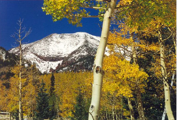
A snow-capped mountain peak looms behind a grove of aspen trees with vibrant yellow autumn leaves under a clear blue sky.
Humphreys Peak framed by autumn foliage in the Kachina Peaks Wilderness.

Kachina Peaks Wilderness history and protected-area timeline

Kachina Peaks Wilderness was formally designated in 1984, becoming part of the National Wilderness Preservation System at a time when many of America's most distinctive high-country areas were receiving elevated protection. Its establishment recognized both the outstanding volcanic and ecological character of the upper San Francisco Peaks and the long-standing cultural significance of the peaks to Indigenous peoples of the Colorado Plateau.

Although the wilderness designation is relatively recent, the land it protects has been central to regional human history for far longer. The peaks have featured prominently in the religious life, oral traditions, and seasonal practices of the Hopi and their neighbors for generations, and shrines within the wilderness continue that tradition today.

The area has also been shaped by a long history of natural resource use around the San Francisco Peaks, including timber, grazing, and later recreational development, with the city of Flagstaff and Arizona Snowbowl lying in close proximity. Designation as wilderness placed this particular high-elevation core under stronger restrictions, helping to preserve both its fragile alpine ecosystems and its sacred landscape qualities.

Kachina Peaks Wilderness landscape and geographic character

The landscape of Kachina Peaks Wilderness is defined by the dramatic high terrain of the San Francisco Peaks, the eroded remnant of a once-massive composite volcano. The trails and routes within the wilderness lead up to some of the highest summits in Arizona: Humphreys Peak, the towering Agassiz Peak, the broad-shouldered Fremont Peak, and the smaller Doyle Peak, all arranged around the great bowl of the Inner Basin.

The Inner Basin itself is a textbook volcanic feature, a caldera formed when the ancient volcano collapsed during its final eruption millions of years ago. Its slopes are steep, its headwalls dramatic, and its upper basin still reads clearly as a collapsed summit rather than an ordinary valley. Around and below the caldera walls, the terrain drops through a sequence of rocky ridges, glacial moraines, and abandoned meltwater channels, making this one of the clearest places in Arizona to read the imprint of both volcanic and Ice Age processes.

The vertical range of the wilderness creates an unusually compressed visual transition. From forested approaches on the lower slopes, the landscape climbs into subalpine parkland, then breaks through the tree line into open alpine tundra-like terrain near the summits. Snow lingers well into summer in shaded chutes and high basins, and the contrast between bare volcanic rock, persistent snowfields, and dark conifer stands gives the wilderness a scenic intensity that belies its small footprint.

Kachina Peaks Wilderness ecosystems, habitats, and plant life

Kachina Peaks Wilderness contains one of the most striking ecological gradients in the American Southwest, compressing several distinct vegetation zones into a small geographic area. The lower elevations are dominated by ponderosa pine and mixed conifer forest typical of the Mogollon Rim country, which grade upward into stands of Douglas-fir, white fir, and eventually spruce-fir forest as elevation increases.

Above the coniferous tree line, the wilderness opens into Arizona's only genuine Arctic-Alpine vegetation zone. This narrow, fragile high-elevation environment is dominated by cushion plants, sedges, grasses, and other hardy alpine species adapted to extreme cold, short growing seasons, and intense ultraviolet exposure. The terrain here includes frost-shattered rock, exposed ridges, and small glacial remnants that together create conditions similar to those found much farther north.

Within this alpine zone, Kachina Peaks Wilderness holds the entire global population of the threatened San Francisco Peaks groundsel, a rare high-elevation wildflower endemic to these summits. Its presence makes the wilderness disproportionately important for plant conservation, despite the small size of the zone that supports it.

Kachina Peaks Wilderness wildlife and species highlights

The wildlife profile of Kachina Peaks Wilderness reflects the strong vertical layering of its habitats. Lower forested slopes support species typical of the Colorado Plateau, including mule deer, black bears, elk, and a wide variety of small mammals such as squirrels and chipmunks. Predators such as mountain lions and coyotes move through the forested terrain, while raptors use the open ridges and cliffs for hunting.

At higher elevations, the coniferous forests provide nesting and foraging habitat for many bird species characteristic of montane western landscapes, including corvids, woodpeckers, and various songbirds adapted to cool, dense forest. Above the tree line, in the sparse alpine zone, wildlife presence is limited but ecologically significant, with hardy species adapted to high winds, short summers, and harsh winters occupying the rocky open ground.

The wilderness also plays an important role in ecological connectivity within the larger San Francisco Peaks complex, allowing wildlife to move between forested habitats around the Inner Basin and the surrounding national forest. This makes the area valuable not just for individual species, but as a functioning high-country ecosystem in northern Arizona.

Kachina Peaks Wilderness conservation status and protection priorities

Kachina Peaks Wilderness holds a unique conservation position in Arizona because of the rare alpine ecosystems within its boundaries. The small Arctic-Alpine zone high on the peaks is the only place in the state where true tundra-like vegetation occurs, and it supports the entire population of the threatened San Francisco Peaks groundsel, making the wilderness a critical site for plant conservation in the Southwest.

By enclosing the highest and most ecologically sensitive portions of the San Francisco Peaks, wilderness designation has provided a legal framework to limit road construction, mechanical development, and heavy infrastructure that could otherwise threaten these fragile communities. The wilderness status also buffers the caldera and inner basin against large-scale disturbance, helping preserve both the geological features and the ecological processes that shaped them.

Beyond its biological role, conservation responsibility in this wilderness extends to the protection of its cultural landscape. As a place sacred to multiple tribal nations, the area's conservation significance includes the preservation of religious sites, traditional use areas, and natural features embedded in oral tradition, giving the wilderness a combined natural and cultural value that is unusual in the National Wilderness Preservation System.

Kachina Peaks Wilderness cultural meaning and human context

Kachina Peaks Wilderness carries profound cultural meaning for several Indigenous nations of the American Southwest, most prominently the Hopi, but also the Havasupai, Navajo, and Zuni. In Hopi belief, the peaks are the seasonal home of kachinas, powerful spirit beings who are believed to dwell on the summits during part of the year and who are associated with the arrival of summer monsoon clouds and rain crucial to agriculture on the Hopi mesas.

The cultural importance of the peaks is not merely historical. Religious shrines and ceremonial sites have been identified within the wilderness, and some continue to be actively used today. The wilderness therefore contains a living cultural landscape in which natural features such as springs, ridges, and summits are woven into prayer, pilgrimage, and traditional ecological knowledge.

This enduring significance has shaped the management and public perception of the area. It also gives visitors a reminder that the San Francisco Peaks are not just a scenic backdrop to Flagstaff, but a sacred high place whose meaning to Indigenous communities long predates the establishment of the wilderness designation or the surrounding town.

Top sights and standout views in Kachina Peaks Wilderness

Kachina Peaks Wilderness is a compact but unusually rich protected landscape that combines Arizona's highest mountain, a textbook volcanic caldera, the state's only true Arctic-Alpine zone, and a sacred landscape central to multiple Indigenous traditions.

For visitors, the highlights include climbs to Humphreys Peak, exploration of the Inner Basin, and cross-country skiing or snowshoeing in winter under some of the highest and coldest conditions accessible in Arizona. For ecologists and conservationists, the wilderness stands out for protecting the only habitat of a federally threatened alpine plant. For cultural visitors, it is a place where geology, ecology, and living religious tradition converge on a single mountain massif.

Best time to visit Kachina Peaks Wilderness

Summer is the most accessible and popular window for experiencing Kachina Peaks Wilderness, when alpine trails above the Inner Basin are largely snow-free and the high peaks can be climbed under long daylight hours. This period also corresponds to the traditional seasonal importance of the summits in Hopi cosmology, when kachinas are believed to bring summer rains to the mesas below.

Winter transforms the wilderness into a quieter, colder landscape dominated by snow, attracting backcountry skiers, snowboarders, and snowshoers willing to manage deep snowpack and harsh weather at high elevation. Visitors in winter should be prepared for sub-freezing temperatures, deep snow at the SNOTEL Snowslide Canyon site, and dramatically reduced trail access above the upper basin.

Shoulder seasons offer their own appeal, with crisp air, fewer visitors, and the chance to see the transition between snow and wildflower at the edge of the alpine zone, but conditions can be highly variable and weather shifts rapid at this elevation.

Monthly climate preview

Long-term monthly temperature averages and precipitation records for Arizona

Kachina Peaks Wilderness Climate Normals and Measured Temperature Ranges

Representative coordinate records show measured temperature variations and precipitation distribution across twelve distinct monthly intervals. Reviewing the complete meteorological profile provides comprehensive insight into long-term climate normals for this protected area.
Annual mean10 °C
-1 °C22 °C
Jan-1°
Feb
Mar
Apr
May13°
Jun19°
Jul22°
Aug21°
Sep17°
Oct10°
Nov
Dec-1°
Warmest month
July

21.9 °C

Coolest month
December

-0.9 °C

Wettest month
August

2 mm/day

Driest month
June

0.2 mm/day

Park location guide

Geography guide, regional context, and park location map for Kachina Peaks Wilderness

Kachina Peaks Wilderness park geography, regions, and map view in United States of America

Understand where Kachina Peaks Wilderness sits in United States of America through a broader geographic reading of the surrounding landscape, nearby location context, and its mapped position within the national park landscape.

How Kachina Peaks Wilderness fits into United States of America

The United States of America is a federal presidential republic and one of the world's largest countries by area and population. It consists of 50 states across a vast territory spanning multiple time zones, with its capital in Washington, D.C. and largest city in New York City. The nation has a diverse economy, influential political system, and significant cultural and military presence globally.

Wider geography shaping Kachina Peaks Wilderness in United States of America

The United States occupies a vast territory in North America, bordered by Canada to the north and Mexico to the south. The 48 contiguous states stretch from the Atlantic to the Pacific Ocean, while Alaska occupies the northwestern region and Hawaii is an archipelago in the Pacific. The country encompasses diverse terrain including the Rocky Mountains, Appalachian Mountains, Great Plains, and extensive river systems.

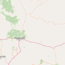
Map view of Kachina Peaks Wilderness

Use this park location map to pinpoint Kachina Peaks Wilderness in United States of America, understand its exact geographic position, and read its mapped placement within the surrounding landscape more clearly.

Pigeon | © OpenStreetMap contributors

Location context for Kachina Peaks Wilderness

ArizonaCoconino County
Recorded earthquake history

Review the Historical Earthquake Catalog for Kachina Peaks Wilderness

Examine documented seismic events in the vicinity of Kachina Peaks Wilderness through our structured historical catalog. MoriAtlas offers a clear view of recorded epicentres, magnitudes, and depths for this region, providing valuable geographic context for those exploring the seismic history of Arizona landscapes.

Kachina Peaks Wilderness Earthquake History

Catalogued events

20 events

Strongest magnitude

Magnitude 5.3

Most recent event

May 10, 2023

This history includes earthquakes recorded inside the park or within 50 km of its borders

Visual reference guide to high alpine terrain, rugged calderas, and protected ecosystems.

Kachina Peaks Wilderness Photos and Volcanic Mountain Landscapes

Visual documentation captures the dramatic topography, volcanic calderas, and fragile alpine vegetation zones defining the high elevation terrain. Examining protected area imagery provides a clear understanding of the rugged volcanic relief and rare tundra habitats found across the summits.

A snow-capped mountain peak looms behind a grove of aspen trees with vibrant yellow autumn leaves under a clear blue sky.

A dirt hiking trail winding through a dense pine forest on a mountainside, with tall evergreen trees flanking the path.

Park atlas

Compare surrounding high country terrain and related regional protected landscapes.

Explore Protected Areas and Parks Near Kachina Peaks Wilderness

Browse other parks near Kachina Peaks Wilderness to evaluate connected mountain ecosystems and regional volcanic terrain. Continuing into adjacent protected areas provides a broader geographic perspective on the high elevation geography of the American Southwest.
A horizontal watercolor illustration showing a calm lake in the foreground, surrounded by grassy banks, evergreen trees, and rolling mountains in the distance under a pale sky.
Protected landscapeArizona
11 km away#1 closest

North

Kaibab National Forest: Protected Plateau Landscapes and Forested Geography in Arizona

High-elevation forest terrain bordering the Grand Canyon

Spanning over 1.6 million acres in Arizona, Kaibab National Forest is characterized by its split geographic configuration, with distinct sections flanking the North and South rims of the Grand Canyon. The terrain ranges from the high-altitude Kaibab Plateau to volcanic uplands near Williams, encompassing four designated wilderness areas and varied forest ecosystems that provide a critical buffer for the surrounding canyon country.

Area
6,500 km²
Established
1909
Relief
Mountain
Climate
Temperate
A watercolor painting showing a winding river flowing through a forested valley with gentle hills in the background.
Wildlife reserveArizona
28 km away#2 closest

Southwest

Red Rock-Secret Mountain Wilderness: A Geographic Overview of Arizona Protected Lands

Canyon landscapes and high mesa terrain in Arizona

Red Rock-Secret Mountain Wilderness serves as a significant protected block near Sedona, featuring a complex network of slot canyons, natural arches, and sandstone pinnacles. This wilderness area preserves the ecological transition from the high-elevation forested rim down into warmer, arid canyon bottoms, offering a deep look at the geology of the Colorado Plateau edge.

Area
191 km²
Established
1984
IUCN
Ib
Relief
Mountain
Watercolor painting of a calm lake surrounded by green forests and distant mountain ridges.
Protected areaArizona
37 km away#3 closest

Southwest

Prescott National Forest: Geographic Overview of Arizona Protected Landscapes and Wilderness

Regional geography and protected terrain map of the Bradshaw Mountains

Spanning over one million acres, Prescott National Forest represents a defining outdoor landscape in Arizona. The terrain transitions from high desert chaparral to dense ponderosa pine forests, featuring eight distinct wilderness areas, rugged canyon systems, and essential watershed corridors that shape the regional ecology near Prescott.

Area
5,100 km²
Established
1908
Relief
Mountain
Climate
Temperate
A horizontal watercolor illustration depicting a desert landscape with distant purple mountain peaks, rolling green hills, and a winding path, rendered in soft, light colors.
Wildlife reserveArizona
46 km away#4 closest

South

Munds Mountain Wilderness Protected Area and Red Rock Landscape Mapping

Arizona high-desert wilderness and canyon-edge geography

Located southeast of Sedona, Munds Mountain Wilderness encompasses roughly 18,150 acres of dramatic sandstone cliffs and elevated plateaus. This area serves as a key site for observing the convergence of pinyon-juniper woodlands with iconic desert rock formations, providing a clear window into the rugged topography of central Arizona.

Area
73.45 km²
Established
1984
IUCN
Ib
Relief
Mountain
National parkArizona
69 km away#5 closest

Northwest

Grand Canyon National Park: Arizona National Park Protected Landscape & Geography

Explore mapped boundaries and regional atlas context.

Grand Canyon National Park stands as a premier national park, showcasing a unique protected landscape within Arizona's diverse geography. This detailed entry focuses on the park's specific geographic identity, its mapped boundaries, and its significance within the regional atlas. Discover the contours of this protected area and its place in the natural terrain of the American Southwest.

Area
4,926.08 km²
Established
1919
IUCN
II
Visitors
4.9M annual
Protected landscapeArizona
95 km away#6 closest

South

Tonto National Forest: Understanding the Geography of an Expansive Protected Landscape

Exploring the vertical ecosystem gradients in Central Arizona

Spanning from arid Sonoran basins to the towering Mogollon Rim, Tonto National Forest offers a unique study in vertical geography and protected land management. This expansive territory provides a vital map of Southwest life zones, encompassing reservoir systems, rugged river canyons, and critical wilderness habitat that define the environmental identity of the region.

Area
11,627 km²
Established
1905
Visitors
5.9M annual
Relief
Mountain
Wildlife reserveArizona
99 km away#7 closest

South

Mazatzal Wilderness: Geographic Overview of Arizona's Expansive Protected Mountain Terrain

Mapping the ecological transition from desert canyon to forest ridge

Mazatzal Wilderness stands as an essential protected area in central Arizona, covering vast tracts of the Tonto and Coconino National Forests. The landscape is defined by the stark vertical contrast between the low-lying Verde River corridor and the high-elevation forests of the Mazatzal Mountains. This expansive wilderness remains a key study in regional topography and ecological zonation for those exploring the rugged backcountry of the southwestern United States.

Area
1,021.4 km²
Established
1964
IUCN
Ib
Relief
Mountain
Wildlife reserveYavapai County
About 118 km away#8 closest

West

Juniper Mesa Wilderness: Geological Landscape and Protected Area Mapping

Essential protected land data in Yavapai County

Juniper Mesa Wilderness protects a rare sedimentary mesa capped by Tapeats sandstone, rising above a vast granite landscape in Yavapai County. This geographic survey highlights the canyon-cut topography and the shifting vegetation zones that characterize the Transition Zone ecology within the Prescott National Forest.

Area
29.97 km²
Established
1984
IUCN
Ib
Relief
Mountain

Common questions about visiting, size, designation, and location context for Kachina Peaks Wilderness

Kachina Peaks Wilderness FAQs for park facts, access, geography, and protected area context

Find quick answers about Kachina Peaks Wilderness, including protected-area facts, park geography, trail and visitor context, and how the park fits into its surrounding country and regional landscape.
MoriAtlas Explorer

Continue Your Protected Areas Search Across the Global Atlas

Deepen your exploration by continuing the structured search for national parks and protected areas worldwide. Utilize the comprehensive filtering capabilities to compare different conservation landscapes and refine your understanding of global park geography. Discover more about the distribution and characteristics of protected natural areas.

Global natural geography