Mori Atlas logo
Wildlife reserveKalakpa Game Production Reserve

Tracing the ecological mosaic of forest and savanna terrain along the Togo Mountain foothills

Kalakpa Game Production Reserve: A Detailed Geographic Survey of Protected Landscapes in the Volta Region of Ghana

Kalakpa Game Production Reserve encompasses a significant protected landscape spanning 320 square kilometers in southeastern Ghana. This wildlife reserve functions as a critical forest and savanna ecotone where dry woodlands interlock with dense gallery forests across the lower slopes of the Togo Mountains. The terrain offers a complex mosaic of rocky hills and valley drainage systems that sustain vital bird populations and native woodland ecosystems within the Volta Region.

forest reservesavannaecotonewoodlandgallery forestTogo Mountains

Kalakpa Game Production Reserve

Wildlife reserve

Park overview

Structured park overview, official facts, and landscape profile for Kalakpa Game Production Reserve

Kalakpa Game Production Reserve park facts, protected area profile, and essential visitor context

Review the core facts for Kalakpa Game Production Reserve, including designation, size, terrain, visitor scale, habitats, and operating context in one park-focused overview.

About Kalakpa Game Production Reserve

Kalakpa Game Production Reserve occupies a meaningful place in Ghana's network of protected areas as one of the larger reserves in the southeastern part of the country. Spanning roughly 320 square kilometers, it protects a landscape where the humid forests of West Africa transition into drier guinea savanna, a transition zone known ecologically as an ecotone. Such ecotones are often disproportionately rich in species because they combine elements of both adjacent biomes, and Kalakpa embodies this pattern through its mixture of dry woodland, gallery forest, and rocky hill terrain.

The reserve is located on the foothills of the Togo Mountains, which run along the border between Ghana and Togo. This geographic setting gives the landscape its varied topography, with elevations rising gradually from the surrounding lowlands and rocky outcrops breaking up the vegetation cover. The regional setting, in the Volta Region near the town of Ho, places the reserve within reach of several local communities whose relationship with the land has evolved alongside the reserve's history.

Kalakpa's ecological importance is formally recognized within the international conservation community. BirdLife International has designated it an Important Bird Area, a status reserved for sites that support significant populations of bird species, whether through breeding, migration, or year-round residence. Combined with its forest-savanna mosaic and its protection under multiple layers of national and international recognition, Kalakpa represents a notable example of Ghana's effort to conserve its transitional ecosystems in a landscape that has long been shaped by both natural processes and human activity.

Quick facts and research context for Kalakpa Game Production Reserve

Kalakpa Game Production Reserve was established in 1975 by the Government of Ghana and covers approximately 32,000 hectares in the Ho Municipal Area of the Volta Region. It lies about 120 kilometers northeast of Accra and 30 kilometers south of Ho, the regional capital. The reserve lies within the forest-savanna ecotone and contains distinctive dry woodland dominated by Borassus and Combretum species, with gallery strips of semi-deciduous rainforest crossing the landscape. It is classified as IUCN Category VI, a protected area with sustainable use of natural resources, and has been recognized as an Important Bird Area by BirdLife International.

Protection and recognition

Examine terrestrial protected area designations and management frameworks.

Kalakpa Game Production Reserve Protection Status and Governance Data

Kalakpa Game Production Reserve features documented terrestrial protection status and administrative management parameters. Structured records compile available designation history and international recognition sources for detailed analysis.

Protection details

Protection scope
Terrestrial
Transboundary protection
No
Park context

Deeper park guide and search-rich context for Kalakpa Game Production Reserve

Kalakpa Game Production Reserve history, landscape, wildlife, and travel context

Explore Kalakpa Game Production Reserve through its history, landscape character, ecosystems, wildlife, conservation priorities, cultural context, and seasonal travel timing in a structured park guide built for atlas discovery and search intent.

Why Kalakpa Game Production Reserve stands out

Kalakpa is best known for its position within the forest-savanna ecotone, where dry Borassus, Combretum woodland interlocks with gallery strips of semi-deciduous rainforest across a landscape of rocky hills. The reserve's formal recognition as an Important Bird Area reflects the significant bird populations that the mosaic of woodland and forest patches sustains. Combined with its location on the lower slopes of the Togo Mountains, this gives Kalakpa a distinctive ecological character within Ghana's protected-area system.

Kalakpa Game Production Reserve history and protected-area timeline

The Kalakpa Game Production Reserve was formally established in 1975 by the Government of Ghana as part of the country's effort to protect representative ecosystems and manage wildlife resources in the southeastern part of the country. Before its designation as a reserve, the area was primarily used as a hunting ground favored by expatriates living in Ghana, reflecting the broader colonial-era pattern of game management in West Africa that often emphasized recreational hunting over conservation.

Following Ghanaian independence and the gradual evolution of the country's wildlife policy, the area was transitioned into a formally protected reserve with a focus on game production and ecological conservation. Over the decades since its establishment, the reserve has had to contend with growing pressures from surrounding communities, including reports of agricultural encroachment, illegal logging, and informal settlement within reserve boundaries. These pressures have prompted periodic interventions from regional authorities, including calls in 2018 for enforcement measures to relocate encroaching communities from four host districts in the Volta Region.

Kalakpa Game Production Reserve landscape and geographic character

Kalakpa's landscape is shaped by its position on the lower slopes and foothills of the Togo Mountains, the long ridge that marks the border between Ghana and Togo. Rather than presenting a single uniform terrain, the reserve is composed of a mosaic of rocky hills, gently undulating lowlands, and valley systems where vegetation patterns shift according to soil, drainage, and elevation. The rocky hills break up the woodland canopy and create variation in microhabitats across the reserve.

The broader landform setting places Kalakpa within a transitional geography between the Volta Basin and the eastern uplands of Ghana. Drainage from the Togo Mountains feeds seasonal streams that cross the reserve and support the gallery forest strips that contrast with the surrounding dry woodland. Together, these features produce a landscape that combines the openness of savanna country with the structural complexity of rocky uplands and the dense vegetation of valley forests.

Kalakpa Game Production Reserve ecosystems, habitats, and plant life

The defining ecological feature of Kalakpa is its position within the forest-savanna ecotone, the transitional belt where the closed-canopy forests of the West African forest zone fragment and dissolve into the more open guinea-savanna landscapes further north. This ecotone character is expressed through the reserve's vegetation, which is dominated by dry woodland featuring Borassus palms and Combretum trees, two characteristic species of the African savanna biome.

Interrupting the dry woodland are galleries, narrow strips of semi-deciduous rainforest that follow watercourses and moister valley bottoms through the reserve. These gallery forests act as ecological corridors and concentration points for biodiversity within an otherwise drier matrix. The combination of woodland, gallery forest, rocky hill terrain, and seasonal streams creates a structurally diverse habitat that supports a wide range of plant and animal life across a relatively compact area.

Kalakpa Game Production Reserve wildlife and species highlights

Kalakpa's mosaic of dry woodland, gallery forest, and rocky hills supports a notable diversity of birdlife, which has been formally recognized through the reserve's designation as an Important Bird Area by BirdLife International. The combination of savanna and forest-edge habitats makes the reserve particularly valuable for species that depend on ecotonal conditions, including those that move between forest interiors and more open landscapes across seasons.

The reserve's larger mammals and other fauna reflect its position as a game production reserve, with the broader landscape offering a mix of savanna and forest-edge habitats that support species associated with both biomes. The presence of gallery forest corridors within the wider dry woodland matrix also supports species that depend on denser vegetation cover, adding to the wildlife interest of the area beyond its importance for birds.

Kalakpa Game Production Reserve conservation status and protection priorities

Kalakpa Game Production Reserve plays a meaningful role in Ghana's conservation landscape by protecting a representative section of the forest-savanna ecotone, one of the most ecologically distinctive transitions in the country. Its formal classification as an IUCN Category VI reserve, a protected area with sustainable use of natural resources, reflects the dual goals of conserving ecological values while allowing certain compatible uses of natural resources within its boundaries.

The reserve's recognition as an Important Bird Area by BirdLife International elevates its conservation profile beyond national borders, placing it within a global framework for the protection of sites of significance for bird populations. At the same time, the reserve has faced significant conservation challenges, including agricultural encroachment, illegal logging, and informal settlement by communities from surrounding districts. These pressures have prompted responses from regional authorities and highlight the ongoing tension between landscape protection and the needs of nearby populations, an issue that will continue to shape the reserve's future management.

Kalakpa Game Production Reserve cultural meaning and human context

The Kalakpa reserve lies within a region of Ghana long inhabited by Ewe-speaking communities, whose traditional livelihoods have historically intersected with the forests, woodlands, and hills of the Volta Region. Before its formal protection, the area functioned as a hunting ground frequented by expatriates during the colonial period, a history that reflects both the colonial origins of wildlife policy in West Africa and the longer-standing relationships between local communities and the surrounding landscape.

Today, the reserve is bordered and partly inhabited by communities from four districts in the Volta Region: Adaklu, Ho West, Ho, and Central Tongu. The relationship between these communities and the reserve has been a defining dimension of Kalakpa's history, producing both cultural ties to the land and ongoing tensions over land use, resource access, and the practical challenges of managing a large protected area in a populated landscape.

Top sights and standout views in Kalakpa Game Production Reserve

Kalakpa's most distinctive qualities lie in the ecological richness of its forest-savanna mosaic, where dry Borassus–Combretum woodland interlocks with gallery strips of semi-deciduous rainforest across the foothills of the Togo Mountains. The reserve's formal recognition as an Important Bird Area highlights its importance for bird populations in a region where savanna and forest habitats meet. Set against the regional context of southeastern Ghana, the reserve offers a large, ecologically varied protected landscape that combines natural value with an enduring history of human interaction.

Best time to visit Kalakpa Game Production Reserve

The most favorable period for experiencing Kalakpa's landscapes is generally the drier season, when the savanna woodland is more open and accessible and the contrast between dry woodland and gallery forest is most visually distinct. During this period, the rocky hill terrain and the broader mosaic of vegetation can be appreciated under clearer atmospheric conditions. The wet season transforms the landscape into a denser, lusher setting, with the gallery forests expanding visually along watercourses and seasonal streams becoming more active.
Monthly climate preview

Long-term monthly temperature and precipitation patterns sampled from representative coordinate data.

Kalakpa Game Production Reserve Climate Normals and Annual Temperature Rhythm

Representative coordinate records show sustained warm monthly averages alongside distinct shifts in precipitation across the annual cycle. Detailed twelve-month climatology data provides deeper insight into measured temperature ranges and rainfall distribution.
Annual mean27 °C
25 °C29 °C
Jan28°
Feb29°
Mar28°
Apr28°
May27°
Jun26°
Jul25°
Aug25°
Sep25°
Oct26°
Nov27°
Dec27°
Warmest month
February

28.8 °C

Coolest month
July

24.8 °C

Wettest month
June

5.6 mm/day

Driest month
January

0.5 mm/day

Park location guide

Geography guide, regional context, and park location map for Kalakpa Game Production Reserve

Kalakpa Game Production Reserve park geography, regions, and map view in Ghana

Understand where Kalakpa Game Production Reserve sits in Ghana through a broader geographic reading of the surrounding landscape, nearby location context, and its mapped position within the national park landscape.

How Kalakpa Game Production Reserve fits into Ghana

Ghana, officially the Republic of Ghana, is a West African nation spanning approximately 240,000 km² along the Gulf of Guinea. It achieved independence from Britain in 1957, becoming the first Sub-Saharan colony to do so, and transitioned to a republic in 1960. The country has a population of over 35 million, with Accra as its capital and largest city. Ghana features diverse ecosystems from coastal savannas to tropical rainforests and is linguistically and ethnically rich, with English as the official language.

Wider geography shaping Kalakpa Game Production Reserve in Ghana

Ghana is located in West Africa along the Gulf of Guinea and Atlantic Ocean to its south. It borders Côte d'Ivoire to the west, Burkina Faso to the north, and Togo to the east. The country spans diverse ecologies including coastal savannas and tropical rainforests.

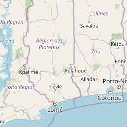
Map view of Kalakpa Game Production Reserve

Use this park location map to pinpoint Kalakpa Game Production Reserve in Ghana, understand its exact geographic position, and read its mapped placement within the surrounding landscape more clearly.

Pigeon | © OpenStreetMap contributors

Location context for Kalakpa Game Production Reserve

Volta Region
Park atlas

Compare adjacent forest reserves and transitional landscapes across the region

Explore Parks Near Kalakpa Game Production Reserve and Surrounding Protected Areas

Browse nearby protected areas and regional conservation zones situated along the transitional foothills of the Togo Mountains. This geographic comparison helps trace wider ecological patterns beyond the borders of Kalakpa Game Production Reserve.
Wildlife reserveVolta Region
About 48 km away#1 closest

North

Tafi Atome Monkey Sanctuary: Mapping Ghana's Community Protected Wildlife Reserves

Protected sacred grove geography in the Volta Region

Tafi Atome Monkey Sanctuary preserves a unique tropical forest ecosystem that has been protected by local tradition for over two centuries. Located in the Volta Region of Ghana, this wildlife reserve demonstrates the significance of community-based conservation. View the sanctuary through the lens of its forest structure, primate populations, and the surrounding rural mosaic that makes this site a key element of the region's protected landscape.

Established
1993
Relief
Lowland
Climate
Tropical
Access
Access unknown
A watercolor painting showing a soft, impressionistic landscape of Keta Lagoon, featuring patches of green vegetation, yellow grasses, and calm water against a light, airy background.
Protected areaVolta Region
About 76 km away#2 closest

Southeast

Keta Lagoon Protected Area: Coastal Wetland Geography and Regional Landscape Mapping

A vital ecological and cultural landscape in Ghana's Volta Region

Keta Lagoon represents a primary coastal wetland system in eastern Ghana. Spanning the coastline between sandy barriers and inland floodplains, this protected area features a unique mosaic of mangroves, tidal flats, and islands. Its role as a major waterbird habitat and the center of Anlo-Ewe cultural life makes it a significant site for understanding West African coastal geography and environmental conservation.

Area
1,200 km²
Established
1992
Relief
Lowland
Climate
Tropical
Wildlife reserveGreater Accra Region
About 106 km away#3 closest

Southwest

Sakumo Ramsar Site Wildlife Reserve: Geographic and Protected Landscape Overview

Coastal lagoon and savanna wetland within the Greater Accra Region

Located along the southern coast of Ghana, the Sakumo Ramsar Site functions as a unique wildlife reserve where a seasonally shifting lagoon meets freshwater marshes and coastal savanna. This map-focused profile examines the ecological boundaries and terrain features of this significant wetland, which serves as a vital sanctuary for migratory birds despite its position within the dense urban fabric of the Accra-Tema metropolitan area.

Area
14 km²
Established
1992
Relief
Lowland
Climate
Tropical
A horizontal watercolor painting depicting a winding river flowing through a lush green landscape with distant hills under a light sky.
Biosphere reserveBenin
About 118 km away#4 closest

East

Mono Transboundary Biosphere Reserve: Mapped Protected Landscapes and Regional Geography

Coastal river deltas, wetlands, and savanna transition zones

The Mono Transboundary Biosphere Reserve preserves a critical intersection of freshwater river systems and marine coastal environments. Stretching along the border of Benin and Togo, this protected area includes expansive mangroves, lagoons, and floodplains that transition into inland savanna. The geography of the reserve reflects a dynamic interface between land and water, encompassing a range of natural terrain that supports both ecological conservation and integrated regional land use.

Area
3,462.85 km²
Established
2017
Relief
Lowland
Climate
Tropical
A horizontal watercolor painting showing a winding river flowing through a lush marshy landscape with distant hills in the background.
Nature reserveGreater Accra Region
About 131 km away#5 closest

Southwest

Densu Delta Ramsar Site: Coastal Wetland Geography in the Greater Accra Region

Protected nature reserve, lagoon network, and tidal marshland

Located at the mouth of the Densu River, this Ramsar site features an interconnected system of mangroves, salt pans, and shallow lagoons. The protected area serves as an essential coastal buffer and bird habitat, showcasing the complex interplay between riverine freshwater and the marine environment of the Gulf of Guinea.

Area
58.93 km²
Established
1992
Water
Water-dominated
National parkBono East Region
About 133 km away#6 closest

Northwest

Digya National Park: Ghana's Oldest National Park, Bordering Lake Volta

Explore its unique geography and mapped protected boundaries.

Digya National Park is a significant protected area in Ghana, renowned as the nation's oldest, established in 1900 and gazetted as a national park in 1971. Occupying 3,743 square kilometers in the Bono East Region, it is distinctively bordered on three sides by the vast Lake Volta, creating an unparalleled terrestrial-aquatic habitat interface. This national park represents a key point in Ghana's geographic atlas, situated in a transitional zone between forest and savanna ecosystems, and is a vital hub for wildlife conservation and the study of its unique landscape character.

Area
3,743 km²
Established
1971
IUCN
II
Relief
Lowland
Protected areaOuémé
About 168 km away#7 closest

East

Basse vallée de l'Ouémé, lagune de Porto-Novo, lac Nokoué: Benin Wetland and Protected Area

Geographic analysis of a major West African riverine and lagoon system

Spanning the lower reaches of the Ouémé River, this protected wetland area in southern Benin integrates complex fluvial and coastal landscapes. The territory includes Lake Nokoué and the Porto-Novo lagoon, creating a vital hydrological basin that supports seasonal floodplains, mangrove fringes, and significant ecological connectivity. Examine the mapped boundaries and natural terrain of this unique West African environmental corridor.

Area
916 km²
Relief
Lowland
Climate
Tropical
Access
Access unknown
Wildlife reserveCentral Region
About 172 km away#8 closest

Southwest

Muni-Pomadze Ramsar Site: Protected Coastal Wetlands and Forest Reserves in Ghana

Coastal lagoons, mangrove stands, and undulating hill geography

Covering a compressed sequence of coastal and inland landforms, the Muni-Pomadze Ramsar Site serves as a significant protected landscape. This area encompasses the Muni Lagoon, shoreline dunes, and the forested slopes of the Yenku and Egyasimanku Hills, creating an ecologically diverse habitat that defines the geography of the surrounding coastline.

Area
3 km²
Established
1992
IUCN
II

Common questions about visiting, size, designation, and location context for Kalakpa Game Production Reserve

Kalakpa Game Production Reserve FAQs for park facts, access, geography, and protected area context

Find quick answers about Kalakpa Game Production Reserve, including protected-area facts, park geography, trail and visitor context, and how the park fits into its surrounding country and regional landscape.
MoriAtlas Explorer

Continue Your Protected Areas Search Across the Global Atlas

Deepen your exploration by continuing the structured search for national parks and protected areas worldwide. Utilize the comprehensive filtering capabilities to compare different conservation landscapes and refine your understanding of global park geography. Discover more about the distribution and characteristics of protected natural areas.

Global natural geography