Mori Atlas logo
State or regional parkKalamalka Lake Provincial Park and Protected Area

Mapping the grassland ecosystems and shoreline corridors of this North Okanagan protected area

Kalamalka Lake Provincial Park and Protected Area: Regional Landscape and Geography

Kalamalka Lake Provincial Park and Protected Area serves as a vital conservation foothold for native grasslands and diverse forest stands in the North Okanagan region of British Columbia. This site provides an essential look at the transition from valley floor meadows to forested slopes, framing the northern edge of Kalamalka Lake. By preserving these rare natural habitats, the area highlights the complex environmental history and distinct geological character of the southern Canadian interior.

provincial parkOkanagan ValleyKalamalka Lakegrassland ecosystemshoreline habitatmixed forest

Kalamalka Lake Provincial Park and Protected Area

State or regional park

Park overview

Structured park overview, official facts, and landscape profile for Kalamalka Lake Provincial Park and Protected Area

Kalamalka Lake Provincial Park and Protected Area park facts, protected area profile, and essential visitor context

Review the core facts for Kalamalka Lake Provincial Park and Protected Area, including designation, size, terrain, visitor scale, habitats, and operating context in one park-focused overview.

About Kalamalka Lake Provincial Park and Protected Area

Kalamalka Lake Provincial Park and Protected Area sits at the northern end of the Okanagan Valley, where the landscape transitions from the lakeshore of Kalamalka Lake up into the grass-covered benches and forested slopes that frame the eastern side of the basin. Although it lies within easy reach of Vernon, the park functions as a substantial green refuge along the lake's edge, preserving habitats and open space that have largely been converted to agriculture, development, and settlement elsewhere in the region.

The protected area is a designated Provincial Park and Protected Area under the British Columbia provincial park system, managed by BC Parks, and it has been recognized with an IUCN Category II classification typically reserved for ecologically significant natural areas. Its roughly 978 hectares include shoreline frontage on Kalamalka Lake, dry valley-bottom grasslands, pockets of mixed forest, and the surrounding terrain that has long defined the visual character of this part of the Okanagan.

Beyond its conservation role, the park serves as a year-round outdoor recreation resource for residents and visitors in the North Okanagan. Cross-country ski trails, hiking paths, and forest access points spread through the area, while two recorded archaeological sites underscore the deeper human history embedded in the landscape. The combination of scientific importance, cultural heritage, and accessibility has made the park one of the most visited natural areas around Vernon.

The protected area also forms part of the broader identity of Kalamalka Lake itself. The lake's seasonal colour changes, intensified by calcium carbonate crystal formation and temperature-driven layering, are best appreciated from viewpoints within or near the park, linking the protected area's scenery directly to one of the Okanagan's most recognizable natural phenomena.

Quick facts and research context for Kalamalka Lake Provincial Park and Protected Area

Kalamalka Lake Provincial Park and Protected Area lies in the North Okanagan Regional District of British Columbia, Canada, on the shore of Kalamalka Lake near Vernon. Established on September 11, 1975, it is classified as an IUCN Category II protected area and is managed by BC Parks. The park covers about 978 hectares and protects one of the last substantial remnants of the natural valley-bottom grasslands that historically stretched from Vernon to Osoyoos.

Protection and recognition

Examine terrestrial protection status and documented designation records.

Kalamalka Lake Provincial Park and Protected Area Protection Status

Terrestrial protection status records for Kalamalka Lake Provincial Park and Protected Area outline administrative boundaries and conservation classifications. Documented administrative scope details provide verified geographic facts for conservation researchers and regional park analysts.

Protection details

Protection scope
Terrestrial
Transboundary protection
No
Park context

Deeper park guide and search-rich context for Kalamalka Lake Provincial Park and Protected Area

Kalamalka Lake Provincial Park and Protected Area history, landscape, wildlife, and travel context

Explore Kalamalka Lake Provincial Park and Protected Area through its history, landscape character, ecosystems, wildlife, conservation priorities, cultural context, and seasonal travel timing in a structured park guide built for atlas discovery and search intent.

Why Kalamalka Lake Provincial Park and Protected Area stands out

The park is best known for protecting a remnant of the Okanagan's natural grasslands and for offering shoreline access to Kalamalka Lake, a lake celebrated for vivid seasonal colour changes. As summer arrives, calcium carbonate crystals form in the warming water and create striking blue and green hues, while cooler transitional seasons sometimes produce deep blue ribbons visible from within the park. Equally important to its identity is the combination of open grassland, mixed forest, and recreational trail networks that link the conservation landscape with the neighbouring community of Coldstream and the city of Vernon.
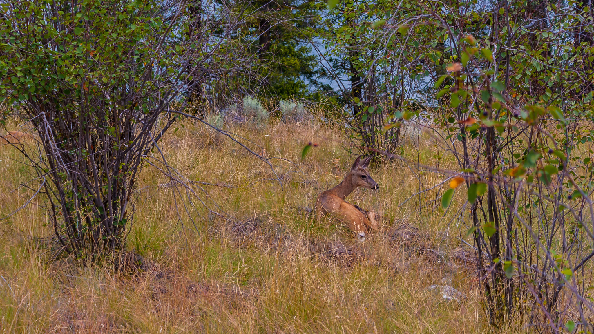
A brown deer lying down in tall, dry yellow grass surrounded by scattered shrubs and trees.
A deer resting in the grassy landscape of Kalamalka Lake Provincial Park.

Kalamalka Lake Provincial Park and Protected Area history and protected-area timeline

Kalamalka Lake Provincial Park and Protected Area was formally established on September 11, 1975, as a protected area within the British Columbia provincial park system. Its creation reflected growing recognition of how rare intact natural grasslands had become in the Okanagan Valley, where decades of agricultural conversion, settlement, and pastoral use had reduced continuous native grassland to scattered remnants.

By setting aside roughly 978 hectares of shoreline, grassland, and forest near Coldstream, the province secured a representative sample of the once-vast grass-covered valley landscape that historically stretched from Vernon south to Osoyoos. The park's name is taken directly from Kalamalka Lake, the body of water it borders.

Two archaeological sites recorded within the park point to a much longer human relationship with this landscape, predating the establishment of the modern park. While detailed archaeological interpretation is limited in the available sources, their presence confirms that the area has long carried cultural and resource significance for the Indigenous peoples and earlier inhabitants of the Okanagan. The protected area continues to be managed by BC Parks as both a conservation landscape and a publicly accessible recreational space near Vernon.

Kalamalka Lake Provincial Park and Protected Area landscape and geographic character

The landscape of Kalamalka Lake Provincial Park and Protected Area is defined by the eastern shore of Kalamalka Lake and the rising terrain that climbs gently away from it. Near the water, the park includes shoreline flats and low benches, while moving inland the land rises into dry, grass-covered slopes that are typical of the natural valley grasslands of the Okanagan. These open grasslands give the park an expansive, sky-oriented character that contrasts with the denser Douglas-fir and mixed forests that occupy the moister draws and upper slopes within its boundaries.

A signature visual feature associated with the park is the surface of Kalamalka Lake itself. In late spring and into summer, warming water encourages the formation of calcium carbonate crystals that scatter incoming sunlight, producing vivid turquoise and emerald tones. During cooler transitional periods in spring and fall, temperature layering sometimes produces deep blue ribbons across the lake, visible from park viewpoints and reinforcing the sense that the surrounding landscape and lake colour shifts together.

The terrain within the park supports a network of trails that traverse open meadows, forest patches, and lakeshore sections. This combination of gentle relief, intermittent tree cover, and water frontage gives the park a varied but approachable topography that reflects the broader Okanagan valley environment.

Kalamalka Lake Provincial Park and Protected Area ecosystems, habitats, and plant life

Kalamalka Lake Provincial Park and Protected Area protects an ecologically valuable mix of dry valley-bottom grassland, mixed forest, and lakeshore habitat, representing landscape types that have become uncommon in the Okanagan. The open grasslands, in particular, are a focal point of the park's ecological identity because they preserve native grass and forb communities that historically covered the valley from Vernon to Osoyoos and have since been heavily altered elsewhere.

Alongside the grasslands, the park contains forest stands and forest-grassland transition zones that support a more mesic environment, while the Kalamalka Lake shoreline introduces lacustrine and riparian habitat elements along the park's boundary. The resulting mosaic supports a wider range of wildlife and plant communities than any single habitat type would on its own, and it provides migration corridors and seasonal range for species that move between grassland, forest, and water.

The protected status of the area ensures that these grassland and forest habitats remain relatively undisturbed compared to surrounding private and agricultural lands, making the park an important refuge for the ecological communities that once characterized this stretch of the Okanagan Valley.

Kalamalka Lake Provincial Park and Protected Area wildlife and species highlights

Wildlife in Kalamalka Lake Provincial Park and Protected Area reflects the park's mix of grassland, forest, and lakeshore habitats. Mammals documented in or strongly associated with the park include coyote, mule deer and other deer, American black bear, Columbian ground squirrel, marmot, mink, bobcat, and red fox. Several of these species, including the ground squirrel, marmot, and fox, are closely tied to the open grassland and edge habitats that the park preserves.

The forested portions of the protected area provide habitat structure for larger mammals such as black bear, deer, and bobcat, while the lakeshore and riparian fringes support smaller predators and semiaquatic mammals such as mink. The open vistas and forest-grassland edges also create productive conditions for observing wildlife, in part because animals move readily between cover and open feeding areas.

Birdlife and other taxonomic groups are not described in detail in the available source material, but the diversity of habitats suggests the park supports a varied bird community associated with dry interior grasslands, mixed interior forests, and freshwater shoreline environments typical of the Okanagan.

Kalamalka Lake Provincial Park and Protected Area conservation status and protection priorities

Kalamalka Lake Provincial Park and Protected Area plays an important conservation role in the Okanagan because it preserves one of the last sizeable examples of the natural valley grassland ecosystem that historically extended from Vernon to Osoyoos. Most of that original grassland has been converted to agriculture, pasture, or developed land, making the park a critical refuge for native grass communities and the species that depend on them.

Its designation as a Provincial Park and Protected Area under BC Parks, along with its IUCN Category II classification, reflects formal recognition of the park's ecological significance. The protected status provides a level of habitat security that surrounding lands no longer enjoy, allowing grasslands, forest stands, and shoreline habitats to function with relatively limited human disturbance.

By maintaining a connected mosaic of grassland, forest, and lakeshore habitat along Kalamalka Lake, the park also contributes to broader landscape-scale conservation goals in the North Okanagan, supporting species diversity, ecological connectivity, and the long-term viability of native plant and animal communities in a heavily modified valley landscape.

Kalamalka Lake Provincial Park and Protected Area cultural meaning and human context

The park's cultural context is rooted partly in its two recorded archaeological sites, which confirm a long history of human presence and activity in the area around Kalamalka Lake. These sites indicate that the landscape has been meaningful to people long before the modern park was established, and they tie the protected area to broader Indigenous and historical land-use patterns of the Okanagan Valley.

Today the park also carries strong regional identity for the communities of Coldstream and Vernon, serving as a shared natural landmark where ecological conservation, recreation, and cultural heritage intersect along the shore of one of the Okanagan's signature lakes.

Top sights and standout views in Kalamalka Lake Provincial Park and Protected Area

Kalamalka Lake Provincial Park and Protected Area stands out for the unusual combination of protected grassland, forest, and lakeshore within a single accessible valley landscape. Its shoreline on Kalamalka Lake, whose vivid seasonal colours are generated by calcium carbonate crystal formation and temperature layering, makes the park a major scenic destination in its own right.

Equally important are its year-round trail network, its cross-country skiing opportunities, and the presence of two archaeological sites that emphasize the area's deeper human story. Together these features make the park both an ecological stronghold and a cultural and recreational anchor for the North Okanagan.

Best time to visit Kalamalka Lake Provincial Park and Protected Area

Late spring through early summer is one of the most rewarding times to experience the park, when warming lake temperatures promote the formation of calcium carbonate crystals and the surface of Kalamalka Lake takes on its vivid blue and green colours. This period also brings fresh growth to the surrounding grasslands and forests, and offers comfortable conditions for hiking and shoreline exploration.

The cooler transitional seasons of spring and fall occasionally produce deep blue ribbons across the lake and reveal quieter, more reflective conditions in the park. Winter extends the park's appeal by transforming its trail network into cross-country skiing terrain, while surrounding forests and grasslands remain accessible for winter wildlife viewing and quiet walks.
Monthly climate preview

Long-term representative coordinate measurements of monthly temperature and precipitation variation

Kalamalka Lake Provincial Park and Protected Area Climate Normals and Annual Weather Rhythm

Kalamalka Lake Provincial Park and Protected Area exhibits a measured annual temperature range alongside steady monthly precipitation patterns sampled across a representative coordinate. Examining the complete twelve-month record reveals deeper long-term climate normals and detailed seasonal weather distributions.
Annual mean5 °C
-7 °C17 °C
Jan-7°
Feb-5°
Mar-1°
Apr
May10°
Jun13°
Jul17°
Aug17°
Sep12°
Oct
Nov-2°
Dec-7°
Warmest month
July

17.5 °C

Coolest month
January

-7.3 °C

Wettest month
June

1.9 mm/day

Driest month
August

0.8 mm/day

Park location guide

Geography guide, regional context, and park location map for Kalamalka Lake Provincial Park and Protected Area

Kalamalka Lake Provincial Park and Protected Area park geography, regions, and map view in Canada

Understand where Kalamalka Lake Provincial Park and Protected Area sits in Canada through a broader geographic reading of the surrounding landscape, nearby location context, and its mapped position within the national park landscape.

How Kalamalka Lake Provincial Park and Protected Area fits into Canada

Canada is a federal parliamentary constitutional monarchy spanning North America from the Atlantic to the Pacific and Arctic Oceans. With a population of over 41 million, it is officially bilingual in English and French at the federal level. The country gained independence from the United Kingdom through a gradual process culminating in 1982.

Wider geography shaping Kalamalka Lake Provincial Park and Protected Area in Canada

Canada occupies the northern portion of North America, sharing its longest international border with the United States. The country extends from the Atlantic Ocean to the Pacific Ocean and northward into the Arctic Ocean, giving it the longest coastline of any nation.

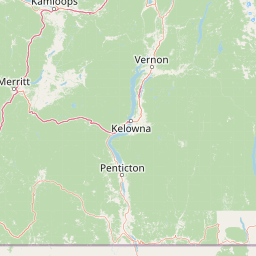
Map view of Kalamalka Lake Provincial Park and Protected Area

Use this park location map to pinpoint Kalamalka Lake Provincial Park and Protected Area in Canada, understand its exact geographic position, and read its mapped placement within the surrounding landscape more clearly.

Pigeon | © OpenStreetMap contributors

Location context for Kalamalka Lake Provincial Park and Protected Area

British Columbia

Visual reference guide to protected valley grasslands, shoreline habitats, and seasonal lake colours

Kalamalka Lake Provincial Park and Protected Area Photos and Landscapes

Visual documentation reveals the distinctive terrain, open valley grasslands, and mixed forest environments preserved within the protected area. Examining park imagery helps clarify the unique shoreline character and shifting blue and green waters of Kalamalka Lake.

A brown deer lying down in tall, dry yellow grass surrounded by scattered shrubs and trees.

Park atlas

Compare adjacent valley reserves and protected landscapes across the surrounding region

Parks Near Kalamalka Lake Provincial Park and Protected Area for Regional Discovery

Browsing other parks near Kalamalka Lake Provincial Park and Protected Area reveals connected Okanagan Valley ecosystems and shared grassland terrain. Evaluating adjacent protected landscapes helps trace regional conservation patterns and environmental geography beyond a single shoreline.
Protected landscapeBritish Columbia
About 38 km away#1 closest

Southeast

Graystokes Provincial Park: Geographic Overview of British Columbia Protected Wilderness

Exploring the Okanagan Highland plateau and alpine wetland systems

Graystokes Provincial Park functions as a key protected landscape in the British Columbia interior. This backcountry expanse is defined by its rolling plateau terrain, encompassing alpine wetlands, meadows, and riparian habitats set against a backdrop of Engelmann spruce and subalpine fir forests.

Area
119.58 km²
Established
2001
Relief
Highland
Climate
Alpine
A watercolor painting showing a serene lake view with forested shoreline, grassy foreground, and rolling mountains in the distance, set against a soft, light background.
State or regional parkBritish Columbia
About 62 km away#2 closest

North

Mara Provincial Park: Protected Shoreline and Geographic Features in British Columbia

Mapping the Shuswap region's essential day-use lakeshore environment

Situated on the southern edge of Mara Lake, Mara Provincial Park functions as a key protected site in the Shuswap region of British Columbia. This area provides public access to sandy beaches and serves as the primary boat launch for the surrounding interior lake system, preserving natural terrain against private lakeshore development.

Area
0.05 km²
Established
1958
IUCN
II
Relief
Lowland
A watercolor painting showing a soft landscape with rolling hills, a winding stream or lake, and grassy vegetation.
State or regional parkBritish Columbia
About 98 km away#3 closest

West

Kentucky Alleyne Provincial Park: Glacial Landscapes and Interior Protected Areas

Mapping kettle lake geography in the British Columbia interior

Kentucky Alleyne Provincial Park preserves a compact, richly varied landscape of kettle lakes, eskers, and dry interior forest. Located in the Nicola region of British Columbia, this protected area offers a clear look at glacial landforms and sun-warmed Ponderosa pine woodlands, standing as a distinct geographic landmark within the Canadian interior range country.

Area
1.9 km²
Established
1981
IUCN
II
Relief
Upland
A horizontal watercolor illustration depicting gentle green hills, a small grove of trees, and a pale ground plane against a white background.
Protected areaBritish Columbia
About 107 km away#4 closest

Northwest

Lac du Bois Grasslands Protected Area: Mapped Geography and Interior Plateau Landscapes

Exploring dryland ecosystems and native prairies in British Columbia.

Located in the Thompson-Nicola Regional District, this protected area spans over fifteen thousand hectares of rolling hills and elevated rocky benches. It remains a flagship example of interior plateau conservation, preserving a unique ecological gradient that stretches from arid sagebrush-covered terrain up into denser montane coniferous forest communities.

Area
157.12 km²
Established
1996
IUCN
II
Relief
Upland
A pale, minimalist watercolor painting showing a soft green treeline along a riverbank with light mountain silhouettes in the distance.
State or regional parkBritish Columbia
About 108 km away#5 closest

South

Inkaneep Provincial Park: Mapped Geography and Protected Riparian Landscapes in British Columbia

Conserving riverine habitats and arid valley biodiversity in the Okanagan

Inkaneep Provincial Park occupies a distinct corridor along the Okanagan River, safeguarding vital riparian vegetation and cottonwood forests in one of Canada's driest regions. This protected area supports important ecological functions, ranging from salmon habitat restoration to providing refuge for rare bird species, representing a meaningful component of the south Okanagan geographic network.

Area
0.205 km²
Established
1956
IUCN
II
Relief
Lowland
National parkBritish Columbia
About 118 km away#6 closest

Northeast

Mount Revelstoke National Park: Explore Protected Landscape Geography and Mapped Boundaries

British Columbia's National Park Atlas Entry

Delve into the protected landscape of Mount Revelstoke National Park, a critical national park located in British Columbia. This entry provides a detailed look at its mapped geographic extent and protected area identity, offering valuable context for regional atlas exploration. Understand the park's distinct contribution to the mapped natural landscapes of Canada.

Area
260 km²
Established
1914
IUCN
II
Visitors
775.2K annual
State or regional parkBritish Columbia
About 121 km away#7 closest

Southeast

Jewel Lake Provincial Park: Geography and Protected Landscapes in British Columbia

A ridge-flanked valley lake with historic mining heritage

Jewel Lake Provincial Park preserves a narrow, forty-nine hectare freshwater ecosystem in the Boundary region of British Columbia. The area provides a detailed look at ridge-flanked mountain terrain and the historical mining landscape that defines this section of the West Kootenay-Boundary corridor.

Area
0.49 km²
Established
1981
IUCN
II
Climate
Temperate
Watercolor painting of a calm river winding through a forested landscape with soft hills in the background at sunset.
State or regional parkBritish Columbia
About 121 km away#8 closest

South

Kettle River Recreation Area: Protected Dry Belt Landscapes and River Geography in British Columbia

Mapping riparian corridors and southern interior ecological zones

Located within the Kootenay Boundary, Kettle River Recreation Area protects a rare intersection of dry ponderosa pine-bunchgrass communities and old growth cottonwood stands. The park creates a distinct geographic enclosure shaped by a sharp S-bend in the river, providing a significant reference point for dry-belt interior ecosystems within the broader British Columbia provincial park network.

Area
1.79 km²
Established
1972
IUCN
II
Relief
Upland

Common questions about visiting, size, designation, and location context for Kalamalka Lake Provincial Park and Protected Area

Kalamalka Lake Provincial Park and Protected Area FAQs for park facts, access, geography, and protected area context

Find quick answers about Kalamalka Lake Provincial Park and Protected Area, including protected-area facts, park geography, trail and visitor context, and how the park fits into its surrounding country and regional landscape.
MoriAtlas Explorer

Continue Your Protected Areas Search Across the Global Atlas

Deepen your exploration by continuing the structured search for national parks and protected areas worldwide. Utilize the comprehensive filtering capabilities to compare different conservation landscapes and refine your understanding of global park geography. Discover more about the distribution and characteristics of protected natural areas.

Global natural geography