
Mori Atlas logo
Nature reserveKalkarer Moor / Tongrube Toni

A compact mosaic of calcareous spring-fed mires and reclaimed open-water mining habitats.

Kalkarer Moor / Tongrube Toni Nature Reserve and Wetland Landscape in North Rhine-Westphalia

(Naturschutzgebiet Kalkarer Moor / Tongrube Toni)

Kalkarer Moor / Tongrube Toni forms a significant protected wetland mosaic within the western Eifel foothills. This nature reserve integrates the ancient botanical heritage of a spring-fed calcareous lowland moor with the modern groundwater-filled basin of a former clay quarry. The terrain supports a complex layering of reedbeds, wet meadows, and alder-dominated woodlands that provide a critical ecological refuge across the agricultural landscape of the Euskirchen district.

calcareous fenlowland moorwetlandreedbednature reserveNaturschutzgebiet
An illustration of a green valley with a winding river flowing through a meadow, surrounded by pine forests and high rocky cliffs with a waterfall cascading down.

Kalkarer Moor / Tongrube Toni

Nature reserve

Park overview

Structured park overview, official facts, and landscape profile for Kalkarer Moor / Tongrube Toni

Kalkarer Moor / Tongrube Toni park facts, protected area profile, and essential visitor context

Review the core facts for Kalkarer Moor / Tongrube Toni, including designation, size, terrain, visitor scale, habitats, and operating context in one park-focused overview.

About Kalkarer Moor / Tongrube Toni

Kalkarer Moor / Tongrube Toni is a compact but ecologically rich nature reserve in the western Eifel foothills of North Rhine-Westphalia. It occupies a low-lying site south of Euskirchen, near the small districts of Kreuzweingarten, Arloff and Kalkar in the municipality of Bad Münstereifel. The roughly 49.6 hectare area sits at the northern margin of the Mersbach valley, where the small Mersbach stream, a tributary of the Erft, flows eastward along the boundary.

The reserve brings together two contrasting landscape elements that historically developed in parallel. The Kalkarer Moor is a spring-fed, calcareous lowland fen built up where groundwater rich in dissolved limestone reaches the surface. Around it, a mosaic of vegetation has developed over more than a century of human use and abandonment. Open calcareous fen surfaces in the southeastern part are largely overgrown with common reed, while black alder woods occupy parts of the southern area. To the northeast lies an extensively managed fresh meadow bordered by a hedgerow, and roughly one third of the total area has become shrubby or succeeded into woodland of trembling aspen, sycamore and silver birch.

The second half of the reserve's identity is the Tongrube Toni, a former clay extraction pit visible on aerial photographs from 1945. After clay mining ceased in 1974, the pit was not backfilled, and rising groundwater gradually filled it, creating a new still-water habitat integrated within the moorland complex. This combination of older wetland and more recent open-water habitat gives the reserve a layered character, where different successional stages meet within easy walking distance.

Ecologically the area is significant because the calcareous groundwater is a prerequisite for the rare calcicolous plant communities that survive today. Botanical interest has been documented here since the mid-nineteenth century, making the area one of the historically important wetland sites in the region. In modern times the reserve is valued for its species-rich wet and nutrient-poor grassland, mire vegetation, marshland birds and invertebrates that depend on these stable hydrological conditions.

Quick facts and research context for Kalkarer Moor / Tongrube Toni

Kalkarer Moor / Tongrube Toni is a designated nature reserve (Naturschutzgebiet) of about 49.6 hectares located south of the city of Euskirchen in the Bad Münstereifel area of North Rhine-Westphalia. It lies within the Kreis Euskirchen and is bordered by the districts of Kreuzweingarten, Arloff and Kalkar. The Mersbach, a tributary of the River Erft, runs along its northern edge. The reserve combines a calcareous, spring-fed lowland moor with a groundwater-filled former clay pit. It is one of the oldest nature reserves in the district, with botanical references dating to the mid-1800s and formal landscape protection from 1935, followed by nature reserve designation in 1965.

Protection and recognition

Documented terrestrial protection metrics and official establishment records

Kalkarer Moor / Tongrube Toni Protection Status and Designation History

Kalkarer Moor / Tongrube Toni maintains a terrestrial protection status established in 1965 under recorded conservation frameworks. Designated records track baseline management scope without assuming external international recognition sources.

Protection details

Protection scope
Terrestrial
Designated year
1965
Transboundary protection
No
WDPA ID
82024
Park context

Deeper park guide and search-rich context for Kalkarer Moor / Tongrube Toni

Kalkarer Moor / Tongrube Toni history, landscape, wildlife, and travel context

Explore Kalkarer Moor / Tongrube Toni through its history, landscape character, ecosystems, wildlife, conservation priorities, cultural context, and seasonal travel timing in a structured park guide built for atlas discovery and search intent.

Why Kalkarer Moor / Tongrube Toni stands out

The reserve is best known for its calcareous fen (Kalkflachmoor), one of the few spring-fed lowland mires still influenced by carbonate-rich groundwater in the western Eifel region. This foundation supports a distinctive mosaic of reedbeds, wet meadows, black alder groves, and wooded areas dominated by aspen, sycamore and silver birch. A second defining feature is the Tongrube Toni, a former clay quarry that was abandoned in 1974 and subsequently filled by rising groundwater, creating an open-water wetland that added new habitat types to the existing moor.
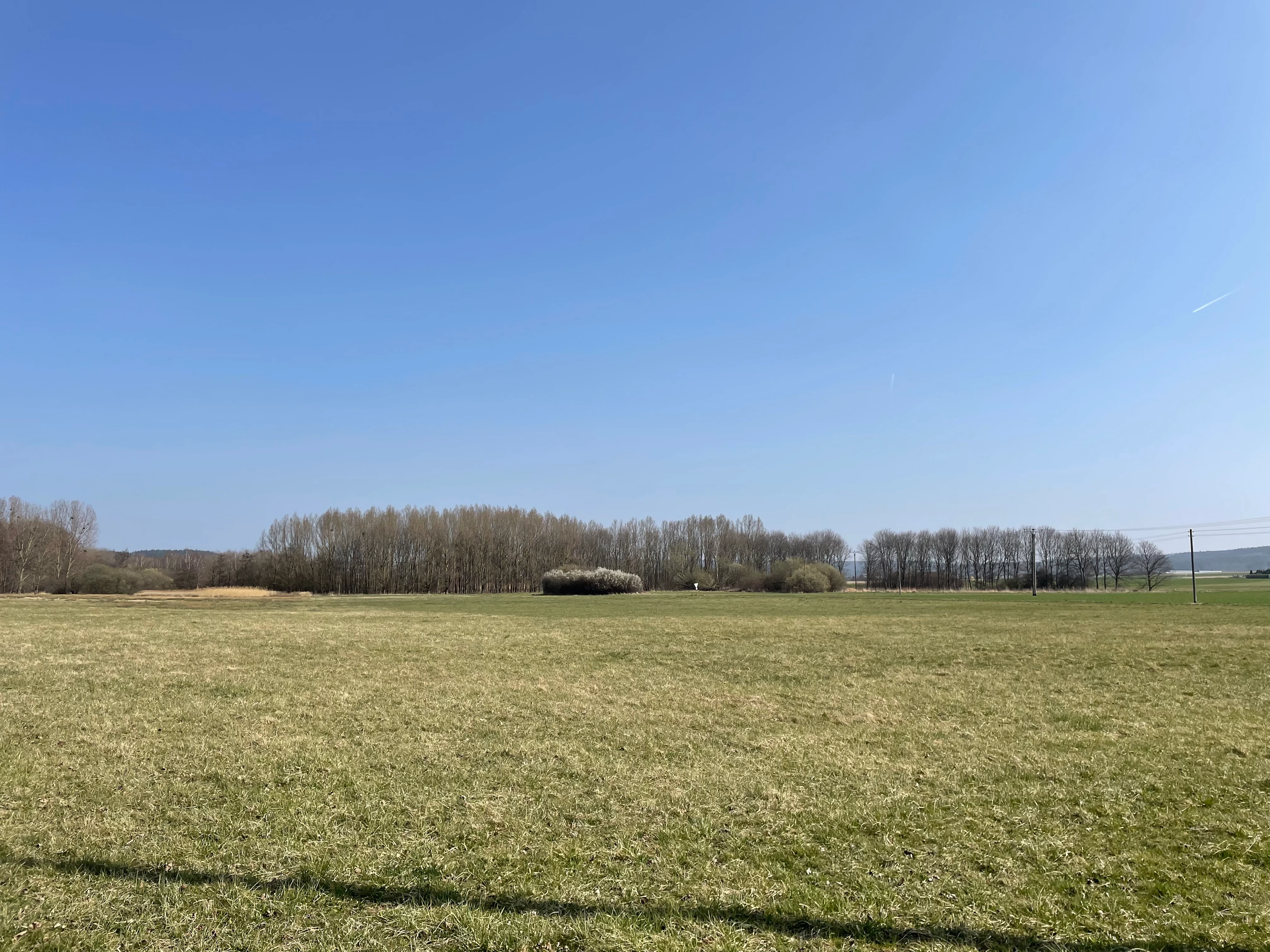
A wide, eye-level landscape shot of a dry, grassy meadow under a clear blue sky, with a line of thin trees in the midground.
A wide view of the open landscape at Kalkarer Moor and Tongrube Toni nature reserve.

Kalkarer Moor / Tongrube Toni history and protected-area timeline

The Kalkarer Moor has a deep land-use history, visible even in early mapping. The Tranchot map, created between 1801 and 1828, already records the area as being used predominantly as meadow and pasture. Botanical literature from the mid-nineteenth century mentions the site because of its unusual flora for the region, establishing its scientific reputation long before formal protection existed.

By the early twentieth century, draining of the surrounding land had begun to take a toll on the mire. Lowering of the water table through increased groundwater extraction caused the spring-fed parts of the moor to dry out substantially by 1918, accompanied by a documented decline in species. In the early 1950s the Mersbach stream was straightened and deepened to improve drainage of the surrounding farmland, and further drying of the source fen was observed during this period. Until the early twentieth century peat was also reportedly cut here for fuel.

Recognition of the area's natural value gradually translated into legal protection. In 1935 the Kalkarer Moor was placed under landscape protection (Landschaftsschutz), and in 1965 parts of it were formally designated as a nature reserve (Naturschutzgebiet), making it one of the older protected sites in the Kreis Euskirchen.

A more recent chapter in the reserve's history is tied to clay extraction. Aerial photographs from 1945 already show the Toni pit and adjacent agricultural parcels. Clay mining continued there until 1974, when the operation was closed. Because the pit was simply abandoned rather than filled, groundwater seeped in and created a new aquatic habitat, effectively expanding the wetland complex.

The single biggest modern turning point came with groundwater management reform. From 2010, after a two-year pause in extraction, the local water association conducted a trial phase that concluded in 2015 with a new extraction plan. Instead of allowing withdrawals of up to 2.5 million cubic metres per year, future use was capped at up to 750,000 cubic metres per year, significantly reducing pressure on the reserve's hydrology and giving the mire a better chance of recovery.

Kalkarer Moor / Tongrube Toni landscape and geographic character

The landscape of Kalkarer Moor / Tongrube Toni is a quiet, low-lying wetland mosaic set within the gently rolling terrain of the western Eifel foothills. The reserve lies in a shallow valley position at the foot of the surrounding agricultural and wooded uplands of Bad Münstereifel, with the Mersbach cutting across its northern edge from west to east.

The defining surface feature is the calcareous flat mire itself (Kalkflachmoor). Its central and southeastern sections are largely covered by tall reed stands that have expanded across the open fen surfaces, creating dense, seasonally swaying stands of common reed. Around this core, the terrain transitions into different habitat types. To the northeast, an extensively managed fresh meadow lies open and flat, framed by a path-side hedgerow that softens the boundary between the reserve and surrounding farmland. In the south, wetter ground supports dense stands of black alder, while along the edges the soil dries out enough for shrub thickets and successional woodland dominated by trembling aspen, sycamore and silver birch to take hold.

The Tongrube Toni introduces a different element of relief. Where the former clay pit lies, the ground drops into a basin, now holding standing groundwater rather than active industrial infrastructure. This sunken pit adds open water and gently sloping shorelines to the mosaic, producing habitat that is structurally distinct from the surrounding marsh and reed.

Overall, the landscape reads as a compact patchwork of small, contrasting features rather than a single broad panorama. The visual strength of the area lies in the way reedbeds, wet woodland, water-filled quarry and managed grassland sit close together, defined by subtle changes in water level, soil chemistry and vegetation height rather than dramatic topography.

Kalkarer Moor / Tongrube Toni ecosystems, habitats, and plant life

Ecologically, the reserve is unusual for the region because the groundwater feeding it is rich in dissolved carbonates. This produces a calcareous, spring-fed fen, a habitat type that has become rare across much of the western Eifel. The combination of stable hydrochemistry and a long history of low-intensity land use has allowed a relatively rich specialist flora and fauna to persist.

Inventories have documented 419 vascular plant species, around 70 moss species and a Charophyte algae (Armleuchteralge), some of which do not occur naturally elsewhere in the broader region. The vegetation mosaic includes reed-dominated fen surfaces, moist and nutrient-poor grassland, black alder swamp woodland, and drier successional woodland of aspen, sycamore and silver birch. The result is a layered vegetation pattern where open fen, marsh, wet woodland and dry woodland meet within a short distance.

The wet conditions also shape nutrient dynamics. The management plan explicitly aims to prevent further eutrophication and the spread of dense reed stands, both of which can displace the more diverse fen communities. Maintaining low nutrient input from surrounding farmland and avoiding further drainage are central to keeping the habitat spectrum intact.

The slightly acidic and base-rich mosaic supports a range of invertebrates, mosses and algae that depend on stable, clean water conditions, which is a key reason why the area has been flagged as regionally important for conservation.

Kalkarer Moor / Tongrube Toni wildlife and species highlights

The reserve is particularly notable for its birdlife, which depends on the combination of reedbeds, wet woodland, open water and damp grassland. Species recorded within the area include common snipe (Bekassine), grasshopper warbler (Feldschwirl), common nightingale (Nachtigall), golden oriole (Pirol), reed bunting (Rohrammer), white ermine moth (Schwarzspanner), short-eared owl (Sumpfohreule), marsh warbler (Sumpfrohrsänger), Eurasian reed warbler (Teichrohrsänger), and water rail (Wasserralle).

Several of these species are tied closely to specific structural elements within the reserve. Marsh warbler, reed warbler, reed bunting and water rail depend on the extensive reedbeds along the fen, while short-eared owl and common snipe favour the more open marsh and rough grassland. Common nightingale and golden oriole are typically associated with the wet woodland edges and shrubby transitions, illustrating how the different habitat patches within the small reserve support distinct bird communities.

Beyond birds, the mosaic of fen, water-filled quarry and woodland edges provides habitat for a range of invertebrates and small wetland-dependent mammals, although detailed information on these groups is limited. From a conservation standpoint, the continued presence of marsh-nesting birds and mire-associated species is one of the strongest indicators that the reserve still functions as a viable wetland refuge in this part of North Rhine-Westphalia.

Kalkarer Moor / Tongrube Toni conservation status and protection priorities

Kalkarer Moor / Tongrube Toni is designated as a nature reserve (Naturschutzgebiet) under North Rhine-Westphalian conservation law, and its core objective is the long-term preservation of the calcareous flat mire and its associated flora and fauna. Protection aims to prevent further eutrophication, to halt excessive expansion of reed stands at the expense of more diverse fen communities, and to maintain the high species diversity that has drawn botanists to the site for more than a century.

Active management is closely tied to hydrology. Because the area's botanical value depends on calcareous spring water reaching the surface, the reserve plan calls for refraining from further watercourse engineering on the Mersbach, from fertilizing the surrounding grassland, and from any land-use change that would further lower the water table. Where the original spring-fed fen had partly dried out in the twentieth century, the plan envisages targeted restoration of the source mire (Quellmoor) so that characteristic mire species can recolonize.

A major conservation milestone came in 2015, when a new groundwater extraction plan capped withdrawals at up to 750,000 cubic metres per year, roughly one third of the previously permitted maximum of up to 2.5 million cubic metres. This change is expected to gradually improve the water supply to the reserve and to support recovery of degraded parts of the fen. A 2019 management and development plan published by Kreis Euskirchen lays out the detailed steps for monitoring, restoration and ongoing protection of the site.

Kalkarer Moor / Tongrube Toni cultural meaning and human context

The cultural context of Kalkarer Moor / Tongrube Toni is closely tied to long-standing rural land use in the western Eifel. Historical maps from the early nineteenth century show the area already shaped by meadow and pasture management, while the mid-1800s botanical literature indicates that the site attracted scientific attention from outside the region because of its unusual plant communities. Peat cutting is also reported from earlier in the twentieth century, reflecting a tradition of small-scale, local use of mire resources.

Industrial activity is represented by the Tongrube Toni itself. Clay mining left a visible mark on the landscape during the mid-twentieth century, and although extraction ended in 1974, the abandoned pit has been incorporated into the protected area rather than erased from it. The result is a reserve where centuries of agricultural use, brief industrial use and modern conservation management overlap in the same small catchment.

Top sights and standout views in Kalkarer Moor / Tongrube Toni

The reserve's biggest highlight is the juxtaposition of an ancient calcareous spring-fed lowland moor with a modern open-water wetland created from a former clay pit. Together they provide a layered habitat mosaic of reedbeds, wet meadows, black alder woods and successional shrub in an unusually compact area.

It is also one of the historically and scientifically significant wetland sites in the Kreis Euskirchen, with botanical references dating back to the mid-nineteenth century and formal protection stretching back to 1935. The 2015 reform of groundwater extraction, which sharply reduced permitted withdrawals, gives the reserve an unusually clear story of conservation-driven hydrological recovery.

Best time to visit Kalkarer Moor / Tongrube Toni

Late spring and early summer are generally the most rewarding periods for visiting a calcareous wetland reserve of this type, when the reedbeds are at their tallest and wetland birds such as reed warblers, marsh warblers and reed buntings are most actively calling and breeding. Early mornings tend to be the most productive time for observing these species.

Outside the breeding season, the reserve still has visual interest: autumn brings colour changes in the wet woodland of black alder, aspen and birch, and winter can offer a stark, open view of the fen structure once the reed has died back. Visitors should expect damp, sometimes boggy ground and water-filled sections around the former clay pit regardless of season, so solid footwear is appropriate throughout the year.


Monthly climate preview

Long-term monthly temperature and precipitation data from representative coordinates

Kalkarer Moor / Tongrube Toni Climate Normals and Annual Weather Patterns

Representative coordinate records show measured monthly temperature variations alongside steady precipitation rates across the sampled terrain. Complete twelve-month normals provide deeper analytical context for studying long-term meteorological patterns.
Annual mean9 °C
0 °C18 °C
Jan
Feb
Mar
Apr
May12°
Jun15°
Jul18°
Aug18°
Sep14°
Oct
Nov
Dec
Warmest month
July

17.9 °C

Coolest month
January

0 °C

Wettest month
June

2.5 mm/day

Driest month
April

1.6 mm/day

Park location guide

Geography guide, regional context, and park location map for Kalkarer Moor / Tongrube Toni

Kalkarer Moor / Tongrube Toni park geography, regions, and map view in Germany

Understand where Kalkarer Moor / Tongrube Toni sits in Germany through a broader geographic reading of the surrounding landscape, nearby location context, and its mapped position within the national park landscape.

How Kalkarer Moor / Tongrube Toni fits into Germany

Germany is a federal republic in Western and Central Europe with a population of over 83 million across sixteen constituent states. It is Europe's largest economy by nominal GDP and a major global exporter and importer. The capital is Berlin, and the country borders Denmark, Poland, Czech Republic, Austria, Switzerland, France, Luxembourg, Belgium, and the Netherlands.

Wider geography shaping Kalkarer Moor / Tongrube Toni in Germany

Germany is located in Western and Central Europe, spanning 357,022 km². It borders Denmark to the north, Poland and the Czech Republic to the east, Austria and Switzerland to the south, and France, Luxembourg, Belgium, and the Netherlands to the west. The country has coastlines on the Baltic Sea and North Sea to the north, with the Alps located in the southern region.

Map view of Kalkarer Moor / Tongrube Toni

Use this park location map to pinpoint Kalkarer Moor / Tongrube Toni in Germany, understand its exact geographic position, and read its mapped placement within the surrounding landscape more clearly.

Pigeon | © OpenStreetMap contributors

Location context for Kalkarer Moor / Tongrube Toni

North Rhine-Westphalia

Visual reference collection showcasing calcareous fens, reedbeds, and quarry water bodies

Kalkarer Moor / Tongrube Toni Landscape Photos and Wetland Scenery

Visual documentation captures the varied terrain and protected wetland mosaic of Kalkarer Moor / Tongrube Toni. Detailed imagery reveals spring-fed fens, open water basins, and wet woodland habitats across the reserve.

A wide, eye-level landscape shot of a dry, grassy meadow under a clear blue sky, with a line of thin trees in the midground.

Park atlas

Compare regional wetland reserves and surrounding Eifel landscape features

Explore Protected Areas and Parks Near Kalkarer Moor / Tongrube Toni

Browse nearby nature reserves and protected landscapes situated across the western Eifel foothills. Compare regional wetland habitats to understand wider conservation patterns beyond Kalkarer Moor / Tongrube Toni.
A horizontal watercolor painting depicting a gentle, hazy green landscape with rolling hills, a line of trees, and a foreground meadow.
Protected landscapeNorth Rhine-Westphalia
About 0.1 km away#1 closest

North

Naturpark Rheinland: Geography and Protected Area Overview in North Rhine-Westphalia

A complex metropolitan nature park and lake district

Naturpark Rheinland represents a distinct convergence of reclaimed lignite mining landscapes, quiet lowland forests, and floodplain wetlands. Its mapped boundaries reveal a diverse terrain of ridges and river valleys that define the environmental character of the Cologne-Bonn metropolitan region.

Area
1,045 km²
Established
1959
Relief
Upland
Climate
Temperate
A horizontal watercolor illustration showing red sandstone rock formations nestled among stylized green trees against a pale yellow background.
Nature reserveMechernich
About 6.4 km away#2 closest

West

Katzensteine Nature Reserve: Red Sandstone Formations and Archaeological Heritage in Mechernich

Protected geological terrain in the North Rhine-Westphalia Eifel region

Katzensteine stands as a distinctive protected landscape defined by 15 meter high red Middle Buntsandstein cliffs. Beyond its geological status, the nature reserve links Stone Age archaeology and Roman industrial history within the Veybach valley. This area provides essential context for the broader sandstone belt spanning the Eifel, showcasing the interplay between natural erosion, sediment layering, and long-standing human presence in the German landscape.

Established
1937
Relief
Upland
Climate
Temperate
Access
Access unknown
Nature reserveNorth Rhine-Westphalia
About 10 km away#3 closest

Southwest

Kakushöhle Nature Reserve: Atlas and Geographic Mapping of an Eifel Travertine Landscape

Geographic study of travertine cave formations and archaeological terrain in Germany

Kakushöhle constitutes an essential protected area for understanding travertine rock formation and human history within the Eifel. The site features an open cave complex nestled in the Kakusfelsen, providing a clear window into prehistoric geological and human occupation patterns across the North Rhine-Westphalia landscape.

Area
0.058 km²
Established
1932
Relief
Upland
Climate
Temperate
Watercolor painting of a soft green landscape with a stream flowing through wetlands and light hills in the distance.
Nature reserveNordrhein-Westfalen
About 11 km away#4 closest

Southeast

Houverather Bach und Nebenbäche: Geography and Protected Brook Systems of the Ahr Eifel

A multi-parcel nature reserve spanning wet meadows and stream-side forest corridors

Houverather Bach und Nebenbäche constitutes a unique protected landscape structured around the Houverather Bach. This reserve comprises eight individual parcels that preserve essential riparian habitats, including reed-fringed fish ponds, meadowsweet-rich grasslands, and beech woodland stands. Spanning the boundary regions of the northern Ahr Eifel, this protected area highlights the importance of maintaining small-scale stream valley ecosystems within the district of Euskirchen.

Area
0.692 km²
Established
2007
Relief
Upland
Climate
Temperate
Watercolor illustration of rolling green hills and meadows with patches of pink and yellow flowers
National parkNorth Rhine-Westphalia
About 16 km away#5 closest

West

Eifel National Park: North Rhine-Westphalia Protected Area Atlas

Explore mapped boundaries and regional geography.

Gain a structured understanding of Eifel National Park, a key protected area within Germany's North Rhine-Westphalia region. This page focuses on its geographic identity, detailing mapped boundaries and offering context within the state's broader natural landscapes. MoriAtlas enhances your exploration by presenting Eifel National Park as a distinct entity within a larger geographic framework, ideal for atlas-based research and understanding protected land distribution.

Area
107 km²
Established
2004
IUCN
II
Relief
Upland
Nature reserveNorth Rhine-Westphalia
About 19 km away#6 closest

South

Vogelschutzgebiet Ahrgebirge Nature Reserve, North Rhine-Westphalia Protected Landscape

Mapped ridge terrain and woodland habitat in the western Eifel region

The Vogelschutzgebiet Ahrgebirge serves as a significant nature reserve protecting the North Rhine-Westphalian side of the Ahrgebirge ridge. Its geography consists of dense, near-natural deciduous forests, stream-cut valleys, and deadwood habitats that provide breeding ground for specialist avian species, forming part of a larger interconnected network across the Rhenish Slate Mountains.

Area
5.8 km²
Established
2004
A soft watercolor painting depicting a panoramic landscape with rolling green hills, patches of forest, and gentle terrain.
Nature reserveNordrhein-Westfalen
About 21 km away#7 closest

East

Kottenforst-Waldville Nature Reserve: Protected Landscape Geography and Forest Mapping

A significant oak-hornbeam woodland complex within Nordrhein-Westfalen.

Kottenforst-Waldville comprises extensive, interconnected forest blocks defined by their high-value oak-hornbeam stands and rare woodland pools known as Maare. This protected area supports a dense regional network of spring brooks and floodplain woodlands, serving as a critical refuge for woodpecker populations and raptors within the anthropogenically shaped landscape of the Rhine valley.

Area
35.853 km²
Established
2004
A soft watercolor illustration showing a peaceful landscape with gentle hills, trees, and small ponds reflecting light.
Nature reserveNordrhein-Westfalen
About 22 km away#8 closest

Northeast

Quarzsandgrube Nature Reserve: Geographic Profile and Protected Landscape Context

Protected mosaic of pioneer habitats in the Rhein-Sieg-Kreis

Located on the terrace slopes of the Rhein-Sieg-Kreis, Quarzsandgrube represents a significant refuge for early successional flora and fauna. The site features an uneven terrain of exposed sandy soils and water-filled hollows, providing a vital habitat corridor alongside adjacent protected areas. This detailed geographic profile maps the environmental conditions that define its current status as a protected nature reserve.

Area
0.29 km²
Established
1994
IUCN
IV

Common questions about visiting, size, designation, and location context for Kalkarer Moor / Tongrube Toni

Kalkarer Moor / Tongrube Toni FAQs for park facts, access, geography, and protected area context

Find quick answers about Kalkarer Moor / Tongrube Toni, including protected-area facts, park geography, trail and visitor context, and how the park fits into its surrounding country and regional landscape.
MoriAtlas Explorer

Continue Your Protected Areas Search Across the Global Atlas

Deepen your exploration by continuing the structured search for national parks and protected areas worldwide. Utilize the comprehensive filtering capabilities to compare different conservation landscapes and refine your understanding of global park geography. Discover more about the distribution and characteristics of protected natural areas.

Global natural geography