Mori Atlas logo
Natural monumentKalkberghöhle

Mapping the geological profile and protected habitat boundaries of this unique gypsum cave system

Kalkberghöhle Natural Monument: Cartographic Exploration of a Significant Northern German Karst Landscape

(Segeberger Kalkberghöhle)

Kalkberghöhle serves as a rare geological and biological reference point within the East Holstein uplands of northern Germany. This protected natural monument exhibits a distinctive phreatic gypsum structure formed by long-term karst processes, standing out against the surrounding glacial moraine terrain. Beyond its geological status, the site functions as a critical winter hibernation refuge, defined by its specialized subterranean climate and strictly protected environmental boundaries.

gypsum caveshow cavekarst landscapebatsbat hibernation siteNatura 2000 site

Kalkberghöhle

Natural monument

Park overview

Structured park overview, official facts, and landscape profile for Kalkberghöhle

Kalkberghöhle park facts, protected area profile, and essential visitor context

Review the core facts for Kalkberghöhle, including designation, size, terrain, visitor scale, habitats, and operating context in one park-focused overview.

About Kalkberghöhle

The Kalkberghöhle is a gypsum show cave inside the Segeberger Kalkberg, a prominent hill rising about forty meters above the surrounding young moraine landscape near Bad Segeberg in Schleswig-Holstein, northern Germany. The hill is composed primarily of anhydrite that has been pushed upward through the overlying glacial deposits by the deep movement of underground salt layers, a salt-tectonic origin that explains the presence of soluble rock reaching the surface in an otherwise glacially shaped terrain. Within this gypsum mass, long-term dissolution by groundwater has hollowed out an extensive cave system that today ranks as the second longest gypsum cave in Germany.

Quick facts and research context for Kalkberghöhle

The Kalkberghöhle sits within the Segeberger Kalkberg, a gypsum and anhydrite hill near Bad Segeberg in Schleswig-Holstein that was uplifted by underlying salt movement. It is a phreatic solution cave formed by dissolution of gypsum below a stable karst water table, making it a rare example of a so-called phreatic Laughöhle within a glacial moraine landscape.

It is the northernmost show cave and the northernmost karst cave in Germany, and at roughly 2,260 meters in total surveyed length it is the second longest gypsum cave in the country after the Wimmelburger Schlotte. The cave is also recognized as a Fauna-Flora-Habitat site within the Natura 2000 network because of its exceptional importance as a hibernation site for thousands of bats each winter.

Protection and recognition

Documented terrestrial protection metrics and management history for Kalkberghöhle

Kalkberghöhle Protection Status and Official Designated History

Terrestrial protection status for Kalkberghöhle dates back to its establishment in 1942, reflecting documented conservation framing. Official records compile foundational management history and recognition frameworks to maintain complete geographic profiles.

Protection details

Protection scope
Terrestrial
Designated year
1942
Transboundary protection
No
Park context

Deeper park guide and search-rich context for Kalkberghöhle

Kalkberghöhle history, landscape, wildlife, and travel context

Explore Kalkberghöhle through its history, landscape character, ecosystems, wildlife, conservation priorities, cultural context, and seasonal travel timing in a structured park guide built for atlas discovery and search intent.

Why Kalkberghöhle stands out

The Kalkberghöhle is best known as one of Europe's most important underground bat roosts. Each winter around twenty-five thousand bats of multiple species hibernate in the cave's stable, frost-free passages, drawn by the constant climate conditions deep inside the gypsum massif. Annual bat counts and research dating back to the late 1920s have made the cave a long-term reference site for bat studies in northern Germany. Equally distinctive is the cave itself. As a phreatic gypsum cave set within a glacially formed moraine landscape, it displays the characteristic upside-down triangular dissolution profile of a phreatic Laug cavern, topped by a flat horizontal ceiling rather than the dramatic dripstone formations of limestone show caves. The combination of an unusual geological setting and an outstanding biological role gives the Kalkberghöhle a strongly dual identity.
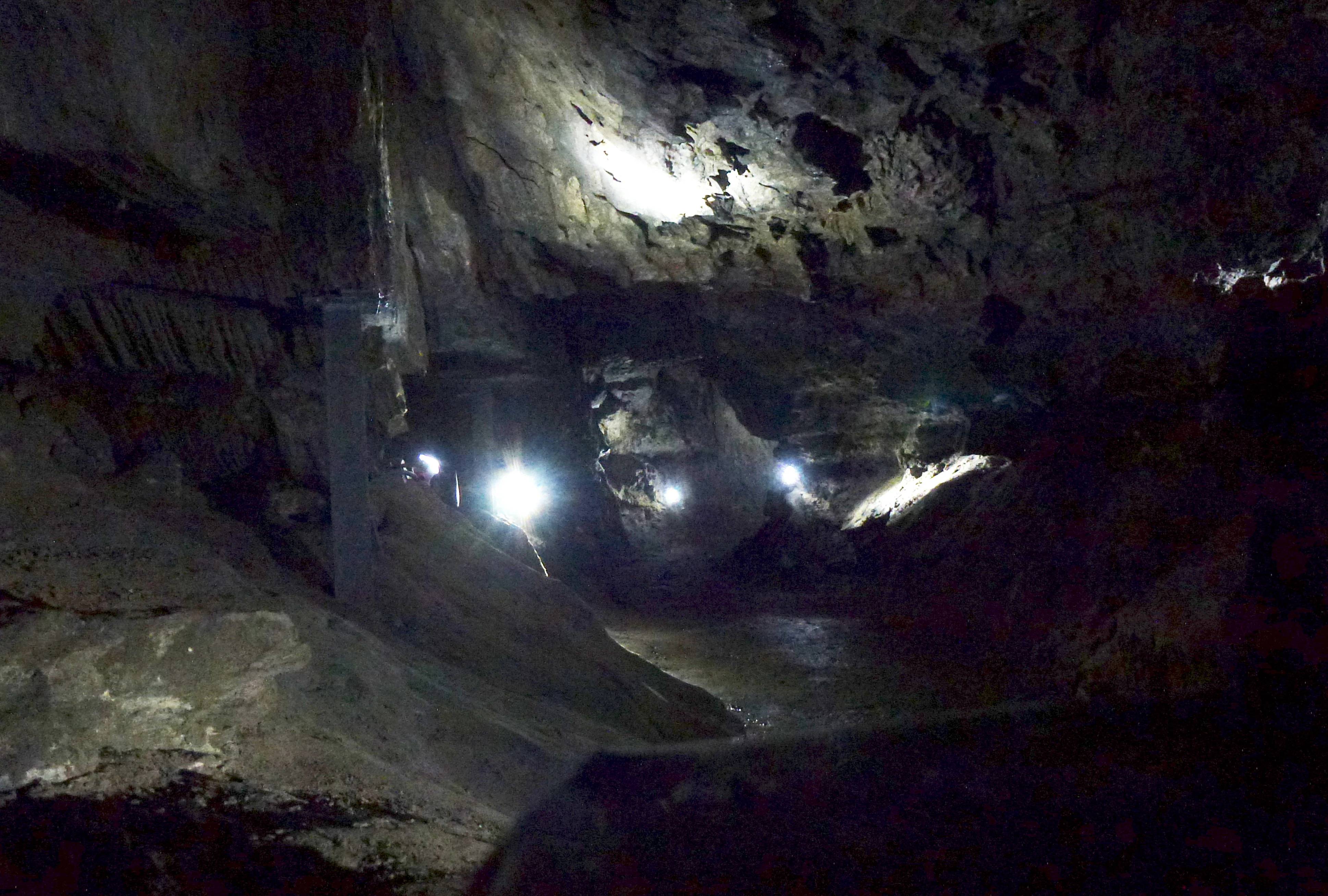
A dimly lit interior view of a natural gypsum cave with rough stone walls, uneven floor, and artificial light sources creating bright spots in the darkness.
The interior of the Kalkberghöhle, showing the rugged cavern walls and pathways.

Kalkberghöhle history and protected-area timeline

The cave was discovered in March 1913 when gypsum miners broke into a hollow in the north face of the Kalkberg. The opening would likely have been passed over as another minor pocket were it not for teacher trainees from the local seminary in Segeberg, who learned of the find from children playing in the quarry and carried out the first proper exploration on March 16, 1913. A more thorough survey followed three days later under the direction of the mine foreman Stolze, and by the end of that same year the cave had been opened to visitors and an initial cave map drawn up.

Kalkberghöhle landscape and geographic character

The Kalkberghöhle lies within a compact gypsum and anhydrite hill that rises abruptly out of the gently rolling young moraine landscape of the East Holstein uplands. Because the hill is built of soluble rock rather than glacial debris, its flanks expose pale, sharply sculpted cliffs that contrast strongly with the surrounding green, hummocky terrain shaped by the last glaciation.

Kalkberghöhle ecosystems, habitats, and plant life

Ecologically, the Kalkberghöhle is dominated by the cave's unusually stable microclimate, which has made it one of the most important hibernation sites for bats in central Europe. The constant humidity, cool but frost-free temperatures, and undisturbed interior passages provide ideal winter conditions for tens of thousands of bats returning year after year.

Kalkberghöhle wildlife and species highlights

The defining wildlife feature of the Kalkberghöhle is its extraordinary bat population. Roughly eight bat species hibernate in the cave, with the winter total reaching around twenty-five thousand animals, and a smaller summer population of roughly eight hundred bats using parts of the cave in the warmer months.

Kalkberghöhle conservation status and protection priorities

Conservation recognition for the Kalkberghöhle has accumulated in stages as the cave's ecological significance became clearer. In 1942 the remaining rock face of the Kalkberg, including the section of cave then known, was designated a natural monument, though parts of the cave system still lay outside the protected area. A new nature conservation ordinance in 1995 finally brought the entire cave within a protected zone and added the nearby Kleiner Segeberger See as an explicit protection target.

Kalkberghöhle cultural meaning and human context

The Kalkberghöhle is closely tied to the identity of Bad Segeberg itself. The town's chalk gypsum hill and the cave within it have long been a focal point of local identity, and the cave's national role as a bat hibernation site has shaped how the community presents itself, including the establishment of the Noctalis bat information and experience center near the cave entrance in 2006.

Top sights and standout views in Kalkberghöhle

The Kalkberghöhle stands out as a uniquely northern karst cave embedded in a glacial landscape, a geological curiosity in its own right, and as one of the largest documented bat hibernation sites in Europe. Its combination of phreatic gypsum cave morphology with an unmatched biological role gives it a profile quite different from most popular German show caves, and its status as a Natura 2000 site underlines how seriously this dual identity is taken.

Best time to visit Kalkberghöhle

From a visitor perspective the cave is approachable mainly in the warmer half of the year, when it is open to guided tours, while in winter the hibernating bat population is protected by a seasonal closure from October through March. Cooler months inside the cave are characterized by silence and careful research access rather than tourism, and summer visits offer the chance to combine the underground experience with the surrounding East Holstein uplands in favorable weather.

Monthly climate preview

Long-term representative monthly averages for temperature and precipitation

Kalkberghöhle Climate Normals and Annual Temperature Rhythm

Representative coordinate records show measured multi-year temperature variations alongside steady precipitation patterns across twelve months. Exploring the full monthly dataset reveals complete temperature ranges and precipitation normals for Kalkberghöhle.
Annual mean9 °C
1 °C18 °C
Jan
Feb
Mar
Apr
May12°
Jun15°
Jul18°
Aug18°
Sep14°
Oct
Nov
Dec
Warmest month
July

17.8 °C

Coolest month
January

0.5 °C

Wettest month
July

2.4 mm/day

Driest month
April

1.3 mm/day

Park location guide

Geography guide, regional context, and park location map for Kalkberghöhle

Kalkberghöhle park geography, regions, and map view in Germany

Understand where Kalkberghöhle sits in Germany through a broader geographic reading of the surrounding landscape, nearby location context, and its mapped position within the national park landscape.

How Kalkberghöhle fits into Germany

Germany is a federal republic in Western and Central Europe with a population of over 83 million across sixteen constituent states. It is Europe's largest economy by nominal GDP and a major global exporter and importer. The capital is Berlin, and the country borders Denmark, Poland, Czech Republic, Austria, Switzerland, France, Luxembourg, Belgium, and the Netherlands.

Wider geography shaping Kalkberghöhle in Germany

Germany is located in Western and Central Europe, spanning 357,022 km². It borders Denmark to the north, Poland and the Czech Republic to the east, Austria and Switzerland to the south, and France, Luxembourg, Belgium, and the Netherlands to the west. The country has coastlines on the Baltic Sea and North Sea to the north, with the Alps located in the southern region.

Map view of Kalkberghöhle

Use this park location map to pinpoint Kalkberghöhle in Germany, understand its exact geographic position, and read its mapped placement within the surrounding landscape more clearly.

Pigeon | © OpenStreetMap contributors

Location context for Kalkberghöhle

Schleswig-Holstein

Examine the unique gypsum cliffs, glacial moraine terrain, and protected habitats of the northernmost German cave.

Kalkberghöhle Photos and Landscapes: Visual Explorer of Northern Karst Scenery

Visual records reveal the striking karst terrain, gypsum cliffs, and subterranean environments that define Kalkberghöhle within the East Holstein uplands. Photographic documentation provides direct insight into the protected habitats, rare geology, and regional scenery surrounding this major European bat roost.

A dimly lit interior view of a natural gypsum cave with rough stone walls, uneven floor, and artificial light sources creating bright spots in the darkness.

Park atlas

Compare nearby protected landscapes and regional geological features across northern Germany

Explore Parks Near Kalkberghöhle and Surrounding Regional Protected Areas

Browsing other parks near Kalkberghöhle allows visitors to examine related protected landscapes, regional geological formations, and diverse natural habitats throughout northern Germany. Expanding the exploration provides valuable geographic context for understanding how unique gypsum caves and glacial moraine terrains connect across the wider regional ecosystem.
Watercolor painting of a wide landscape with green fields, rolling hills, and trees with pink and green foliage.
Protected areaSchleswig-Holstein
About 8.7 km away#1 closest

Southwest

Leezener Au Protected Area: Glacial Tunnel Valley Geography and Habitat Conservation in Schleswig-Holstein

A mapped overview of glacial river corridors and riparian restoration

Discover the geographic essence of the Leezener Au, a protected river corridor shaped by Ice Age glacial activity in Schleswig-Holstein. This area preserves a mosaic of lowland peat, wet meadows, and forested slopes that serve as a crucial habitat link in the regional Trave river basin.

Established
2005
Relief
Lowland
Climate
Temperate
Scope
Terrestrial
Nature reserveSchleswig-Holstein
About 9.1 km away#2 closest

North

Tarbeker Moor Nature Reserve and Glacial Peatland Basin Geography

A restored wetland landscape in Schleswig-Holstein, Germany

Tarbeker Moor functions as a crucial nature reserve that showcases the successful rewetting of a former industrial peatland. Located in a shallow glacial meltwater channel north of Bad Segeberg, the park offers a distinct study in landscape recovery, featuring a dense mosaic of open water, floating vegetation, and diverse amphibian habitats.

Area
1.31 km²
Established
2004
Protected landscapeSchleswig-Holstein
About 25 km away#3 closest

Northeast

Naturpark Holsteinische Schweiz: Geographic Atlas of a Northern German Protected Landscape

Lake-dense glacial regions and forest habitats in Schleswig-Holstein.

Spanning 75,000 hectares across the districts of Ostholstein, Plön, and Segeberg, Naturpark Holsteinische Schweiz offers a rich look at a classic post-glacial landscape. This structured overview details the park's intricate network of lakes, winding streams like the Schwentine, and restored peatlands that support essential waterbird habitats. Gain a deeper understanding of the park's topography, from the Bungsberg ridges to the expansive lowland depressions that define this region.

Area
753.28 km²
Established
1986
Relief
Upland
Climate
Temperate
A watercolor painting showing a soft, panoramic landscape with rolling hills in the background, a small stream winding through a grassy foreground, and a cluster of trees on the right.
Nature reserveSchleswig-Holstein
About 26 km away#4 closest

Southeast

Kannenbruch Nature Reserve in Schleswig-Holstein: A Regional Atlas of Protected Woodland Geography

Mapping the radial forestry lanes and bog-forest ecosystems

Kannenbruch represents a distinctive intersection of cultural history and natural succession within Schleswig-Holstein. The reserve protects a waterlogged, low-lying bog-forest characterized by its deliberate, star-shaped layout of radiating forestry lanes. This structured landscape provides a window into Biedermeier-era spatial planning while supporting a rich diversity of spring-flowering geophytes on its damp, heavy soils.

Area
0.25 km²
Established
1995
Relief
Lowland
Climate
Temperate
Nature reserveSchleswig-Holstein
About 37 km away#5 closest

North

Wald nordwestlich Boksee Nature Reserve: Geographic Atlas and Protected Landscape Mapping

Ancient deciduous woodland within the Schleswig-Holstein moraine region

Wald nordwestlich Boksee stands as a protected nature reserve representative of Central European beech and oak ecosystems. Situated in the Plön district of Schleswig-Holstein, the site offers a detailed look at glacial moraine landscapes, historic boundary embankments, and the ecological management of ancient woodland habitats. This overview provides mapping context and structural insights into the forest's role within the local biodiversity corridor.

Area
0.25 km²
Established
2004
Relief
Upland
Climate
Temperate
Watercolor painting showing a wide, panoramic view of a marshy landscape with green fields, winding water channels, and faint pink clouds in the sky.
Nature reservePinneberg
About 38 km away#6 closest

Southwest

Himmelmoor Nature Reserve and Mapped Peatland Landscape in Pinneberg, Germany

Detailed geography of a restored raised bog

Trace the extensive bog terrain of Himmelmoor in Pinneberg, Germany. This former raised bog is now a focal point for large-scale wetland rewetting. Explore the site's flat, waterlogged geography, industrial heritage, and its protected status as a crucial natural mosaic within the broader regional landscape.

Established
2022
Relief
Lowland
Climate
Temperate
Access
Easy access
A horizontal watercolor painting depicting a soft, ethereal landscape with green trees on the left and right, a winding stream in the center, and pale rolling hills in the background against a light, misty sky.
Nature reserveSchleswig-Holstein
About 39 km away#7 closest

Northwest

FFH-Gebiet Wennebeker Moor und Langwedel Nature Reserve: Geographic and Landscape Atlas

Protected mire and heathland complex in Schleswig-Holstein

The FFH-Gebiet Wennebeker Moor und Langwedel nature reserve encompasses a complex mosaic of wet and dry heath, quaking bogs, and Nardus grasslands. This site is distinguished by its unique integration of conservation obligations with active military land use, creating a rare habitat environment within a gently rolling morainal landscape.

Area
2.3 km²
Established
2004
Relief
Lowland
Climate
Temperate
Nature reserveSchleswig-Holstein
About 42 km away#8 closest

Northwest

Wälder der nördlichen Itzehoer Geest: Protected Area and Forest Landscape Atlas

Natura 2000 ancient woodland in Schleswig-Holstein

Explore the geography of Wälder der nördlichen Itzehoer Geest, featuring four historical forest tracts across glacial moraines. This protected area highlights Atlantic acid beech forests and floodplain habitats, preserving centuries-old woodland continuity within the broader Schleswig-Holstein landscape.

Area
7.11 km²
Established
2004
Relief
Upland
Climate
Temperate

Common questions about visiting, size, designation, and location context for Kalkberghöhle

Kalkberghöhle FAQs for park facts, access, geography, and protected area context

Find quick answers about Kalkberghöhle, including protected-area facts, park geography, trail and visitor context, and how the park fits into its surrounding country and regional landscape.
MoriAtlas Explorer

Continue Your Protected Areas Search Across the Global Atlas

Deepen your exploration by continuing the structured search for national parks and protected areas worldwide. Utilize the comprehensive filtering capabilities to compare different conservation landscapes and refine your understanding of global park geography. Discover more about the distribution and characteristics of protected natural areas.

Global natural geography