Mori Atlas logo
Nature reserveKammereckswiesen und Herchwiesen von Langen

Examining the complex mosaic of dry sandy grasslands and wet meadow landscapes in the Upper Rhine Plain.

Kammereckswiesen und Herchwiesen von Langen Nature Reserve: A Detailed Geographic Overview

(Kammereckswiesen, Herchwiesen, Schmale Wiesen und Belzbornwiesen von Langen)

Kammereckswiesen und Herchwiesen von Langen represents a vital nature reserve situated in the southwestern outskirts of Langen, Hessen. This protected area stands out for its remarkably compact landscape, which interweaves dry aeolian sand ridges with low-lying damp meadows and reed beds. Through our detailed mapping of this Hessian site, observers can trace the ecological connectivity of its diverse habitats, which serve as a critical refuge for rare grassland invertebrates and meadow flora in a suburbanized region.

nature reservemeadowlandgrassland habitatsandy grasslandwet meadowreed bed

Kammereckswiesen und Herchwiesen von Langen

Nature reserve

Park overview

Structured park overview, official facts, and landscape profile for Kammereckswiesen und Herchwiesen von Langen

Kammereckswiesen und Herchwiesen von Langen park facts, protected area profile, and essential visitor context

Review the core facts for Kammereckswiesen und Herchwiesen von Langen, including designation, size, terrain, visitor scale, habitats, and operating context in one park-focused overview.

About Kammereckswiesen und Herchwiesen von Langen

Kammereckswiesen und Herchwiesen von Langen belongs to the category of small, ecologically intensive nature reserves that are common in the highly populated Rhine-Main region of Hesse. Although the protected landscape is not dramatic in scale or in altitudinal relief, it is unusually valuable in ecological terms because it preserves a complex of meadow habitats that have been lost from most of the surrounding lowlands. The reserve sits in a wedge of open land between the Frankfurt-Heidelberg railway line to the east and the Kreisstraße 168 to the west, with the Herchwiesen, Schmale Wiesen, and Belzbornwiesen extending this band of open habitat further east toward the Egelsbacher Weg.

The ecological character of the area is defined by the interaction of two contrasting substrates. In some parts, wind-blown sand (Flugsand) creates dry, nutrient-poor conditions that support thin, herb-rich swards reminiscent of classical sandy grassland. In other parts, heavier clay-rich soils retain moisture and give rise to marsh marigold meadows, reed beds, and tall-sedge communities. This juxtaposition within a single reserve is what gives the site its conservation significance, since it allows species with very different moisture and nutrient requirements to coexist in close proximity.

The reserve's legal framework reflects both national and European priorities for habitat conservation. At the regional level it is designated as a Hessian Nature Reserve (Naturschutzgebiet), managed by the lower nature conservation authority of the Offenbach district. At the European level, the Kammereckswiesen together with the Kirchnerseckgraben stream corridor are part of the Natura 2000 network as a Fauna-Flora-Habitat (FFH) site, ensuring the protection of listed habitat types such as lowland hay meadows and tall-herb fens alongside specific species of conservation concern.

The cultural character of the landscape is closely tied to traditional, extensive grassland farming. The meadows have been maintained through low-intensity mowing and minimal fertilizer use, and the continuation of this regime is the single most important condition for preserving their ecological value. As the surrounding area has become increasingly urbanized, with Langen, Egelsbach, Dreieich, and the Frankfurt conurbation all within easy reach, the reserve has acquired an additional role as a green refuge and a fragment of the older, more rural landscape of the southern Rhine-Main plain.

Quick facts and research context for Kammereckswiesen und Herchwiesen von Langen

The reserve was formally designated in 1982 and is administered by the lower nature conservation authority of the Offenbach district. It was expanded in 2009 to include the Herchwiesen east of the Frankfurt-Heidelberg railway line, and again in 2018 when the Schmale Wiesen and Belzbornwiesen were added, giving the present-day designation its longer official name.

The site is classified under IUCN Category IV as a Habitat/Species Management Area. Its core protected area covers about 28.8 hectares, with a larger 45-hectare FFH (Fauna-Flora-Habitat) zone that also includes the Kirchnerseckgraben stream west of the local Kreisstraße 168 and east toward the A5 motorway. The reserve forms part of the wider chain of protected grassland sites that characterize the rural green spaces between Langen, Egelsbach, and Dreieich.

Protection and recognition

Examine the registered conservation framework and official protected area data.

Kammereckswiesen und Herchwiesen von Langen Protection Status and Records

Kammereckswiesen und Herchwiesen von Langen holds a recorded designation profile within global protected area databases. Reviewers can analyze the official conservation status and administrative metrics associated with this protected landscape.

Protection details

WDPA ID
82033
Park context

Deeper park guide and search-rich context for Kammereckswiesen und Herchwiesen von Langen

Kammereckswiesen und Herchwiesen von Langen history, landscape, wildlife, and travel context

Explore Kammereckswiesen und Herchwiesen von Langen through its history, landscape character, ecosystems, wildlife, conservation priorities, cultural context, and seasonal travel timing in a structured park guide built for atlas discovery and search intent.

Why Kammereckswiesen und Herchwiesen von Langen stands out

The reserve is best known for its remarkably heterogeneous meadows, where species-rich dry sandy grassland and wet meadow communities occur side by side within a very small spatial footprint. This juxtaposition, created by the interplay of wind-blown sand deposits and patches of clay-rich substrate, allows a single meadow complex to host a wide variety of plant and animal species that are otherwise tied to different, geographically separate habitat types. It is also recognized as a refuge for grassland invertebrates, particularly rare butterflies and dragonflies that depend on the continuation of extensive low-input mowing. The presence of botanically notable species such as Allium angulosum, Dactylorhiza majalis, and Dianthus superbus has given the site a reputation among conservation biologists working on traditional meadow habitats in the Rhine-Main area.
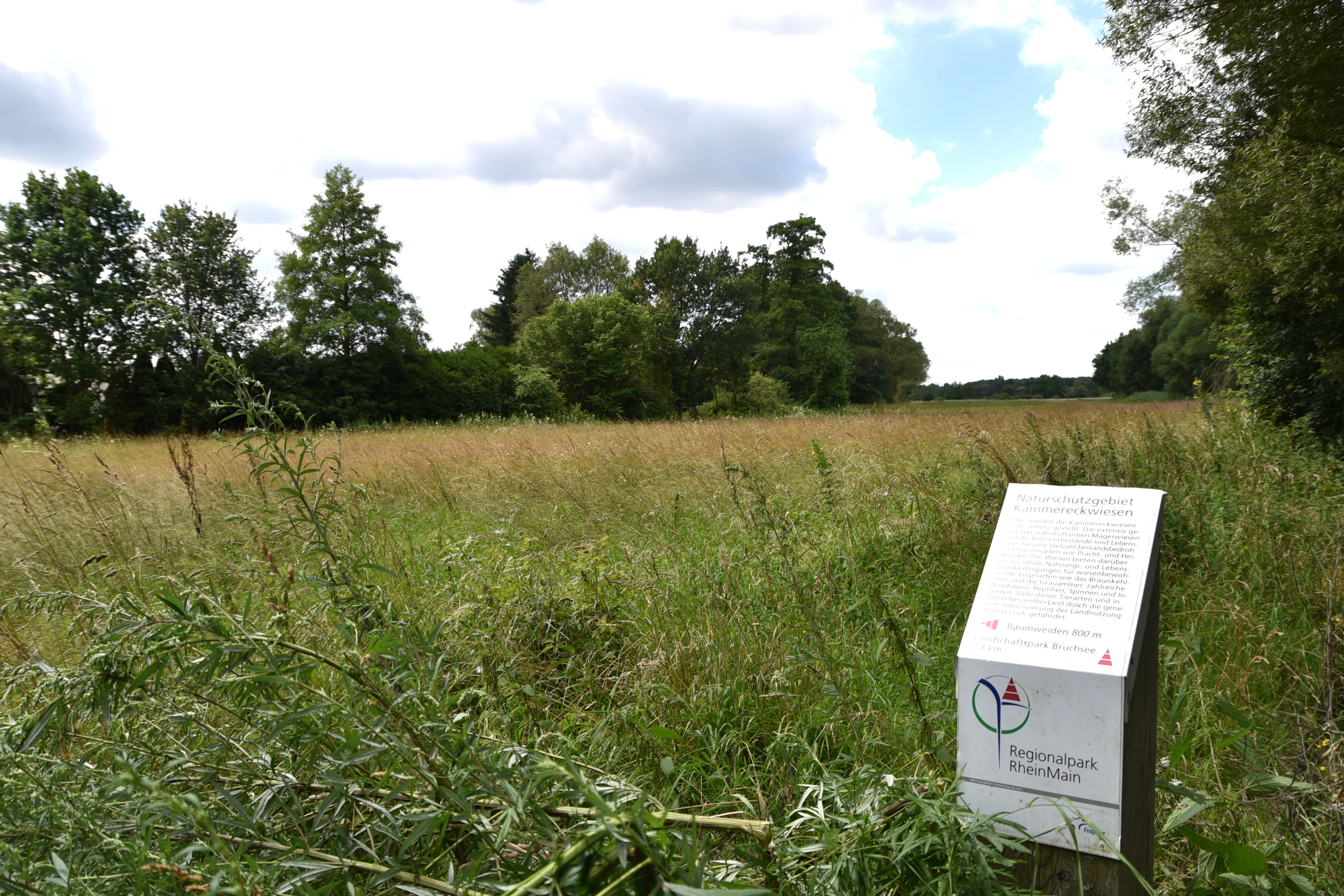
A white information sign stands in the foreground, with a grassy meadow and a line of trees in the background.
Information sign at the Kammereckswiesen und Herchwiesen von Langen nature reserve.

Kammereckswiesen und Herchwiesen von Langen history and protected-area timeline

The nature reserve was first designated in 1982, at a time when many of the traditional meadow complexes in the Rhine-Main lowlands were already under pressure from agricultural intensification, road building, and suburban expansion. Its original designation focused on the Kammereckswiesen, the meadow block west of the Frankfurt-Heidelberg railway, and it was initially understood as a small island of extensive grassland habitat surrounded by increasingly managed land.

A first major expansion occurred in 2009, when the Herchwiesen, a long band of meadow east of the railway line, were incorporated into the reserve. This broadened its ecological footprint and improved connectivity for meadow species that depend on open, low-input habitat. In 2018, further additions were made in the form of the Schmale Wiesen and Belzbornwiesen, extending the protected meadows once more eastward along the edge of the town of Langen. This brought the reserve close to its present-day configuration and gave it the longer official name that reflects all four meadow areas.

In 2000, the Kammereckswiesen together with the Kirchnerseckgraben stream, which runs west of the Kreisstraße 168 toward the A5 autobahn, were recognized as a European Fauna-Flora-Habitat site under the Natura 2000 network. This step gave the meadows a transnational framework for conservation and linked their future management to the EU Habitats Directive. Since the late 1990s, ecological monitoring and management planning have been carried out to evaluate the effectiveness of protection measures and to maintain the extensive grassland character on which the reserve's biodiversity depends.

Kammereckswiesen und Herchwiesen von Langen landscape and geographic character

The landscape of Kammereckswiesen und Herchwiesen von Langen is a lowland meadow landscape, lying just under fifty meters of relief in the Upper Rhine Plain south of Frankfurt. Although it lacks dramatic topographic features, it is visually distinctive because it retains a patchwork of open, herb-rich meadows framed by infrastructure corridors. To the east, the Frankfurt-Heidelberg railway line forms a hard boundary, while to the west runs the Kreisstraße 168; the meadows of the Herchwiesen, Schmale Wiesen, and Belzbornwiesen extend further east toward the Egelsbacher Weg along the edge of Langen.

On a finer scale, the terrain is shaped by the interplay of two substrates. Patches of wind-blown sand (Flugsand) form small dry ridges and flats that support thin, lean grassland. These are interleaved with low-lying areas where clay-rich, sometimes waterlogged soils have produced slightly sunken, damper depressions. The result is a mosaic of dry sandy grassland, mesic meadow, marsh marigold meadow, reed bed, and tall-sedge fen within a very compressed spatial range. Small groves and lines of shrubs (Gehölze) provide additional structural variation and serve as perches for birds and as shelter for invertebrates.

The Kirchnerseckgraben, a small watercourse west of the Kreisstraße 168, further diversifies the landscape. Although it is a modest drainage channel rather than a major river, it contributes a linear wet element to the reserve and is included in the FFH designation precisely because of its value for habitat connectivity. The interplay of dry sand grassland, moist meadow, reed bed, and small stream forms a sequence of micro-landscapes that together produce the visual and ecological richness of the protected area.

Kammereckswiesen und Herchwiesen von Langen ecosystems, habitats, and plant life

Ecologically, Kammereckswiesen und Herchwiesen von Langen is best understood as a species-rich semi-natural grassland complex rather than a wilderness or forest reserve. Its biodiversity is built on the persistence of extensive agricultural use, especially low-intensity mowing and minimal fertilization, both of which allow a wide variety of herbs, grasses, and sedges to coexist.

The drier sandy areas support lean, herb-rich plant communities typical of the regional Flugsand habitats, with species adapted to low nutrient levels and periodic drought. In contrast, the damper clay-influenced patches support marsh marigold meadows, reed bed communities, and large sedge stands. The botanical inventory of the reserve lists species such as Allium angulosum (Kantiger Lauch), Dactylorhiza majalis (Breitblättriges Knabenkraut), and Dianthus superbus (Pracht-Nelke) as particularly noteworthy.

The vegetation mosaic is mirrored by a corresponding diversity of habitat structures, from short-grazed turf to dense reed, from isolated shrubs to linear gallery-like vegetation along the stream. This structural and floristic complexity is what underpins the site's value for invertebrates, birds, and other wildlife. Because the surrounding matrix has become increasingly built-up and intensively farmed, the reserve functions as a relatively self-contained ecological refuge for many species that no longer have viable habitat outside its boundaries.

Kammereckswiesen und Herchwiesen von Langen wildlife and species highlights

The wildlife interest of the reserve centers on invertebrates that depend on the interface between open meadow vegetation and small patches of damp, herb-rich habitat. The mosaic of dry and mesic grasslands supports a particular suite of butterfly and dragonfly species, including butterflies whose life cycles are closely tied to specific meadow plants. Among the most notable species historically recorded is the dark meadow-knapweed blue (Dunkler Wiesenknopf-Ameisenbläuling), a butterfly that is often used as an indicator of the quality of extensive meadow management.

Botanically, the populations of Allium angulosum, Dactylorhiza majalis, and Dianthus superbus have given the reserve particular recognition among botanists working on meadow flora in the Rhine-Main region. Orchids and other meadow specialists rely on the timing and intensity of mowing, and the reserve's continued habitat quality is closely linked to a management regime that allows these species to complete their reproductive cycles.

In the past, the reserve also supported a characteristic set of ground-nesting meadow birds, including lapwing (Kiebitz), whinchat (Braunkehlchen), stonechat (Schwarzkehlchen), and corn bunting (Grauammer). These breeding populations have largely declined or disappeared, reflecting regional trends across much of lowland Germany rather than conditions specific to this site alone. Nevertheless, the reserve still provides important foraging habitat for migrating and wintering birds, and its open character makes it a useful site for observing seasonal changes in the local avifauna.

Kammereckswiesen und Herchwiesen von Langen conservation status and protection priorities

From a conservation perspective, the reserve is significant primarily because it preserves a complex of lowland meadow habitats that have been extensively lost from the Rhine-Main lowlands over the course of the twentieth century. Its designation as a Hessian Nature Reserve gives the meadows legal protection against conversion, intensification, or development, while its inclusion in the European Natura 2000 network frames its management within the goals of the EU Habitats Directive.

The FFH site 'Kammereckswiesen und Kirchnerseckgraben von Langen' contributes to the broader conservation of habitat types such as species-rich lowland hay meadows, tall-herb fens, and reed communities, as well as specific species cited in the directive's annexes. Its small size is offset by the unusually high habitat diversity on site: a single reserve is able to contribute to the conservation status of multiple habitat types at once.

Conservation management is closely tied to continued extensive grassland use. The persistence of the species-rich meadows depends on regular but carefully timed mowing, on the avoidance of fertilizer application, and on the prevention of woody encroachment that would gradually convert the open habitat into scrub. Ecological monitoring carried out since the 1990s has shown that, with appropriate management, the reserve is capable of maintaining its distinctive flora and fauna over the long term, even in the face of strong pressures from its urbanized surroundings.

Kammereckswiesen und Herchwiesen von Langen cultural meaning and human context

The Kammereckswiesen and Herchwiesen fit into a long rural tradition of meadow use in what is now the southern Rhine-Main region. Before suburban expansion transformed the area around Langen, Egelsbach, and Dreieich into a densely populated commuter belt for the Frankfurt metropolitan area, the local landscape was dominated by open farmland, orchards, and meadowland. The reserve preserves a fragment of that older agricultural landscape, in which hay production and extensive grazing shaped both the topography and the biodiversity of the land.

The place names of the meadows themselves reflect this long-standing land use: 'Wiesen' simply means meadows, while locally specific names such as Kammereck, Herch, Schmale, and Belzborn are rooted in micro-topography, historical land parcels, or local hydrological features. Although the original cultural ties to the land have weakened under suburbanization, the reserve still offers a tangible link to the traditional rural environment of the region and serves as an example of how that environment can be integrated into a modern metropolitan setting.

Top sights and standout views in Kammereckswiesen und Herchwiesen von Langen

A particular highlight of Kammereckswiesen und Herchwiesen von Langen is the unusually tight coexistence of dry sandy grassland and damp meadow vegetation in a single compact reserve, producing a level of botanical and structural diversity that would normally require a much larger area. The presence of regionally rare meadow plants, especially orchids and other specialists like Dianthus superbus and Allium angulosum, adds clear scientific and aesthetic value to a modest site.

Best time to visit Kammereckswiesen und Herchwiesen von Langen

Because the reserve is primarily a meadow landscape, its character shifts markedly with the seasons and with the rhythm of mowing. Late spring and early summer are often the most rewarding period for visiting, when the meadows are in full bloom and the variety of plant species is at its most visible. This is also when many of the reserve's key meadow plants, including Dactylorhiza majalis, are flowering.

Mid-summer, after the traditional first cut of hay, gives a different but equally appealing impression, with fresh regrowth and the chance to observe the reserve's butterfly and dragonfly fauna more easily in lower vegetation. For visitors primarily interested in plant diversity, late spring through early summer offers the strongest display; for those interested in insects and open meadow character, mid- to late summer after the first cut can also be rewarding. Autumn and winter visits will mainly show the broader landscape structure and the contrast between the meadow reserve and its surrounding infrastructure corridors.

Monthly climate preview

Long term representative temperature and precipitation patterns across the protected landscape

Kammereckswiesen und Herchwiesen von Langen Climate Normals And Annual Weather By Month

Representative coordinate records show average monthly temperatures ranging from freezing winter lows to warm summer maximums alongside steady daily precipitation rates. Examining the full twelve month profile reveals the complete climatological rhythm for this regional park.
Annual mean10 °C
0 °C21 °C
Jan
Feb
Mar
Apr10°
May14°
Jun18°
Jul21°
Aug20°
Sep15°
Oct10°
Nov
Dec
Warmest month
July

20.6 °C

Coolest month
January

0.2 °C

Wettest month
July

2.2 mm/day

Driest month
April

1.4 mm/day

Park location guide

Geography guide, regional context, and park location map for Kammereckswiesen und Herchwiesen von Langen

Kammereckswiesen und Herchwiesen von Langen park geography, regions, and map view in Germany

Understand where Kammereckswiesen und Herchwiesen von Langen sits in Germany through a broader geographic reading of the surrounding landscape, nearby location context, and its mapped position within the national park landscape.

How Kammereckswiesen und Herchwiesen von Langen fits into Germany

Germany is a federal republic in Western and Central Europe with a population of over 83 million across sixteen constituent states. It is Europe's largest economy by nominal GDP and a major global exporter and importer. The capital is Berlin, and the country borders Denmark, Poland, Czech Republic, Austria, Switzerland, France, Luxembourg, Belgium, and the Netherlands.

Wider geography shaping Kammereckswiesen und Herchwiesen von Langen in Germany

Germany is located in Western and Central Europe, spanning 357,022 km². It borders Denmark to the north, Poland and the Czech Republic to the east, Austria and Switzerland to the south, and France, Luxembourg, Belgium, and the Netherlands to the west. The country has coastlines on the Baltic Sea and North Sea to the north, with the Alps located in the southern region.

Map view of Kammereckswiesen und Herchwiesen von Langen

Use this park location map to pinpoint Kammereckswiesen und Herchwiesen von Langen in Germany, understand its exact geographic position, and read its mapped placement within the surrounding landscape more clearly.

Pigeon | © OpenStreetMap contributors

Location context for Kammereckswiesen und Herchwiesen von Langen

Hessen

Visualizing the rare mosaic of dry sandy grasslands and damp meadow habitats in central Germany

Kammereckswiesen und Herchwiesen von Langen Photos and Protected Area Scenery

Photographic documentation reveals the intricate mosaic of dry sandy ridges and damp clay depressions that characterize this protected lowland meadow environment. Examining these protected area views allows researchers to observe the distinct vegetative zones and structural diversity preserved within the Rhine-Main region.

A white information sign stands in the foreground, with a grassy meadow and a line of trees in the background.

Park atlas

Compare surrounding lowland meadowlands and connected conservation landscapes in the region

Other Parks Near Kammereckswiesen und Herchwiesen von Langen and Regional Protected Areas

Browsing other protected areas near Kammereckswiesen und Herchwiesen von Langen reveals similar lowland grassland habitats and regional meadow ecosystems. Examining these adjacent natural sites provides a broader geographic comparison of conservation landscapes across the surrounding Upper Rhine Plain.
Nature reserveHesse
About 3.2 km away#1 closest

South

Faulbruch bei Erzhausen: Protected Wetland Landscapes and Regional Nature Reserve Atlas

Mapping rare fen woodlands and wet meadow habitats in southern Hesse

This nature reserve protects an ecologically distinct combination of black alder fen, mat grass pastures, and calcareous meadows near Erzhausen. Situated on silty, peaty soils within the southern Hessian lowlands, the site serves as a vital refuge for specialized biodiversity, maintained by its unique groundwater hydrology and surrounding anthropogenic borders.

Area
0.658 km²
Established
2001
Relief
Lowland
Climate
Temperate
A watercolor painting showing a soft, bright landscape with green rolling hills, distant trees, and scattered yellow wildflowers.
Nature reserveHessen
About 6.4 km away#2 closest

Southeast

Im Mörsbacher Grund von Darmstadt-Arheilgen: Geography and Protected Wetland Atlas

Nature reserve landscape mapping in Hessen, Germany

Explore the structured landscape of Im Mörsbacher Grund von Darmstadt-Arheilgen. This nature reserve provides essential habitat connectivity through its wet meadows, orchids, and alluvial woodlands along the Hahnwiesenbach stream, representing an important segment of the regional conservation network.

Area
0.681 km²
Established
1987
IUCN
IV
Scope
Terrestrial
Nature reserveHessen
About 6.7 km away#3 closest

Northeast

Oberwiesen von Sprendlingen Nature Reserve: Landscape and Protected Area Geography

Wet meadows and seminatural grassland in the Hessen region

Located near Dreieich, Oberwiesen von Sprendlingen occupies seventeen hectares of diverse terrain where flat plains meet rolling hills. This nature reserve protects a documented array of fen fragments, reed beds, and tall herb stands, functioning as an ecological bridge within the regional network of protected Hessen landscapes.

Area
0.17 km²
Established
1996
IUCN
IV
Relief
Lowland
A pale, soft watercolor landscape painting of a quiet lake with shoreline reeds, trees in the background, and branches framing the scene on the sides.
Nature reserveHesse
About 6.9 km away#4 closest

South

Am Kleewoog von Gräfenhausen Nature Reserve: Geography and Protected Area Landscape Overview

A regional sanctuary of sand habitats and former gravel pits in Hesse

Examine the distinct ecological geography of Am Kleewoog von Gräfenhausen. This reserve showcases the transition between rugged, water-filled gravel excavations and stable pine-oak forest stands on acidic inland dunes. Gain insight into the regional importance of this protected mosaic as an amphibian refuge and a remnant of the unique geological substrate found across the Darmstadt sand sheet.

Area
0.209 km²
Established
1985
IUCN
IV
Relief
Lowland
A horizontal watercolor painting showing a quiet pond or lake surrounded by low, green vegetation and soft, pastel skies.
Nature reserveHesse
About 7.2 km away#5 closest

North

Gehspitzweiher bei Neu-Isenburg: A Protected Nature Reserve in the Rhine-Main Region of Hesse

Mapping the ecological transition of an abandoned post-industrial extraction site

Gehspitzweiher bei Neu-Isenburg stands as an important nature reserve defined by its sunken basin and diverse habitat mosaic. Located within the Alten Heegwald forest near Frankfurt, this 25-hectare area showcases the natural recovery of former quarry lands into a hotspot for dragonfly, amphibian, and bird species within the Hesse landscape.

Area
0.25 km²
Established
1981
IUCN
IV
Nature reserveHessen
About 7.7 km away#6 closest

Northeast

Luderbachaue von Dreieich: A Protected Floodplain Forest and Habitat in Hessen, Germany

Mapping the ecological geography of a significant lowland nature reserve

Spanning over 290 hectares, Luderbachaue von Dreieich serves as a major protected floodplain forest. The site preserves a diverse mosaic of oak, beech, and alder-ash woodlands that sustain rare fungal communities and old-growth timber, maintaining a vital green corridor in the urbanized Rhine-Main region.

Area
2.938 km²
Established
1996
IUCN
IV
Relief
Lowland
Nature reserveHessen
About 10 km away#7 closest

Southwest

Am Belzberg Nature Reserve: A Detailed Atlas of Protected Sand Grassland Landscapes

Protected natural areas and regional terrain in Hessen, Germany

Explore the specialized geography of Am Belzberg, a nature reserve nestled in the Untermainebene region of Hessen. This protected area represents an essential habitat for dry-substrate plant communities and local fauna, serving as a key example of small-scale conservation management in the lower Main river plain.

Area
0.053 km²
Established
1996
IUCN
IV
A horizontal watercolor illustration depicting a soft, pastel-colored meadow with wildflowers in the foreground and a gentle forest line in the background against a white background.
Nature reserveLandkreis Darmstadt-Dieburg
About 11 km away#8 closest

East

Neuwiese von Messel Nature Reserve: Mapped Geography and Protected Landscape Context

Essential nature reserve located in Landkreis Darmstadt-Dieburg

Neuwiese von Messel consists of open meadow islands surrounded by mature deciduous forest, creating a representative forest-meadow mosaic in the Messeler Hügelland. This nature reserve functions as a vital conservation site for specialized plants and habitat types, protected within the European Natura 2000 network. Gain insight into its terrain, soil-based biodiversity, and the centuries-old traditional management that sustains this protected German landscape.

Area
1.072 km²
Established
1986
IUCN
IV
Relief
Lowland

Common questions about visiting, size, designation, and location context for Kammereckswiesen und Herchwiesen von Langen

Kammereckswiesen und Herchwiesen von Langen FAQs for park facts, access, geography, and protected area context

Find quick answers about Kammereckswiesen und Herchwiesen von Langen, including protected-area facts, park geography, trail and visitor context, and how the park fits into its surrounding country and regional landscape.
MoriAtlas Explorer

Continue Your Protected Areas Search Across the Global Atlas

Deepen your exploration by continuing the structured search for national parks and protected areas worldwide. Utilize the comprehensive filtering capabilities to compare different conservation landscapes and refine your understanding of global park geography. Discover more about the distribution and characteristics of protected natural areas.

Global natural geography