
Mori Atlas logo
Nature reserveKampeters Kolk

A compact heath pond ecosystem showcasing wetland biodiversity and historical basin topography.

Kampeters Kolk Nature Reserve: Mapped Protected Landscapes in the Senne Region of Germany

(Naturschutzgebiet Kampeters Kolk (BI-026))

Kampeters Kolk is a protected nature reserve located within the Senne region of North Rhine-Westphalia, Germany. This site preserves a distinctive mosaic of oligotrophic pond water, wet meadows, and acid heath habitats, functioning as a vital refuge for wetland vegetation and amphibians. Through its unique basin-and-margin geography, the area highlights the ecological importance of remnant peat-cut landscapes within the broader sandy terrain of the Bielefeld territory.

wetlandheath pondSenne landscapenature reserveacid bog vegetationamphibian habitat
A graphic illustration showing a pond with a waterfall in the distance, framed by bare trees and tall grasses in the foreground.

Kampeters Kolk

Nature reserve

Park overview

Structured park overview, official facts, and landscape profile for Kampeters Kolk

Kampeters Kolk park facts, protected area profile, and essential visitor context

Review the core facts for Kampeters Kolk, including designation, size, terrain, visitor scale, habitats, and operating context in one park-focused overview.

About Kampeters Kolk

Kampeters Kolk is one of the smaller, more quietly significant nature reserves within the municipal boundaries of Bielefeld, situated in the sandy Senne landscape in eastern North Rhine-Westphalia. Designated under the identifier BI-026 and classified as an IUCN Category IV Habitat/Species Management Area, the reserve is centered on a shallow pond flanked by wet meadows, sedge beds, reed stands, and willow-buckthorn shrub communities. Together these habitats form a compact but ecologically distinctive mosaic of acid wetland and heath-margin vegetation that contrasts sharply with the surrounding dry Senne sands.

The pond itself originated from historical peat cutting in a small, closed depression where peat had accumulated over time. Turf-extraction created the open water body that defines the landscape of the reserve today, while the nutrient-poor substrate of the surrounding bog and heath margin supported a specialized plant community including heather species, cranberry, bog rosemary, round-leaved sundew, and cotton grass. In its earlier decades the site was celebrated locally as the Rosenteich because of white water lilies that once floated across its surface.

Although the reserve's ecological value has been compromised in recent decades by nutrient influx and water pollution from the surrounding catchment, its designation in 1993 marked an important protective milestone. Today Kampeters Kolk is recognized less for an intact rare-species community and more as a still-functioning wetland habitat and amphibian spawning site within an otherwise dry sandy landscape, alongside a continuing record of ecological change in the Senne region.

Quick facts and research context for Kampeters Kolk

Kampeters Kolk is located in the Senne landscape within the city limits of Bielefeld, North Rhine-Westphalia. It is designated as an IUCN Category IV Habitat/Species Management Area and is officially registered under the identifier BI-026. The protected area covers roughly two hectares and is administered by the lower landscape authority of the city of Bielefeld.

Protection and recognition

Documented conservation records and formal protected area designations

Kampeters Kolk Protection Status and International Recognition Data

Examine official protection records and formal designation details associated with Kampeters Kolk through structured environmental databases. Review verified conservation parameters and international recognition metrics compiled for this protected natural area.

Protection details

WDPA ID
164013
Park context

Deeper park guide and search-rich context for Kampeters Kolk

Kampeters Kolk history, landscape, wildlife, and travel context

Explore Kampeters Kolk through its history, landscape character, ecosystems, wildlife, conservation priorities, cultural context, and seasonal travel timing in a structured park guide built for atlas discovery and search intent.

Why Kampeters Kolk stands out

Kampeters Kolk is best known for its nutrient-poor heath pond surrounded by wet meadows, sedge communities, reed beds, and willow-alder buckthorn shrub thickets. Historically the pond's water surface was ornamented by white water lilies, which gave the site its colloquial name Rosenteich, or 'Rose Pond.' The reserve also preserves a remnant of the acid heath and bog vegetation once characteristic of the Bielefeld Senne landscape. The site is further distinguished by its origin as a turf-cut depression in a small, isolated bog basin, making it a textbook example of a man-influenced yet ecologically valuable Senne heath pond. Although many of the rarer plant species documented in earlier decades have since disappeared due to nutrient enrichment, the reserve still functions as a refuge for wetland flora and amphibian fauna.
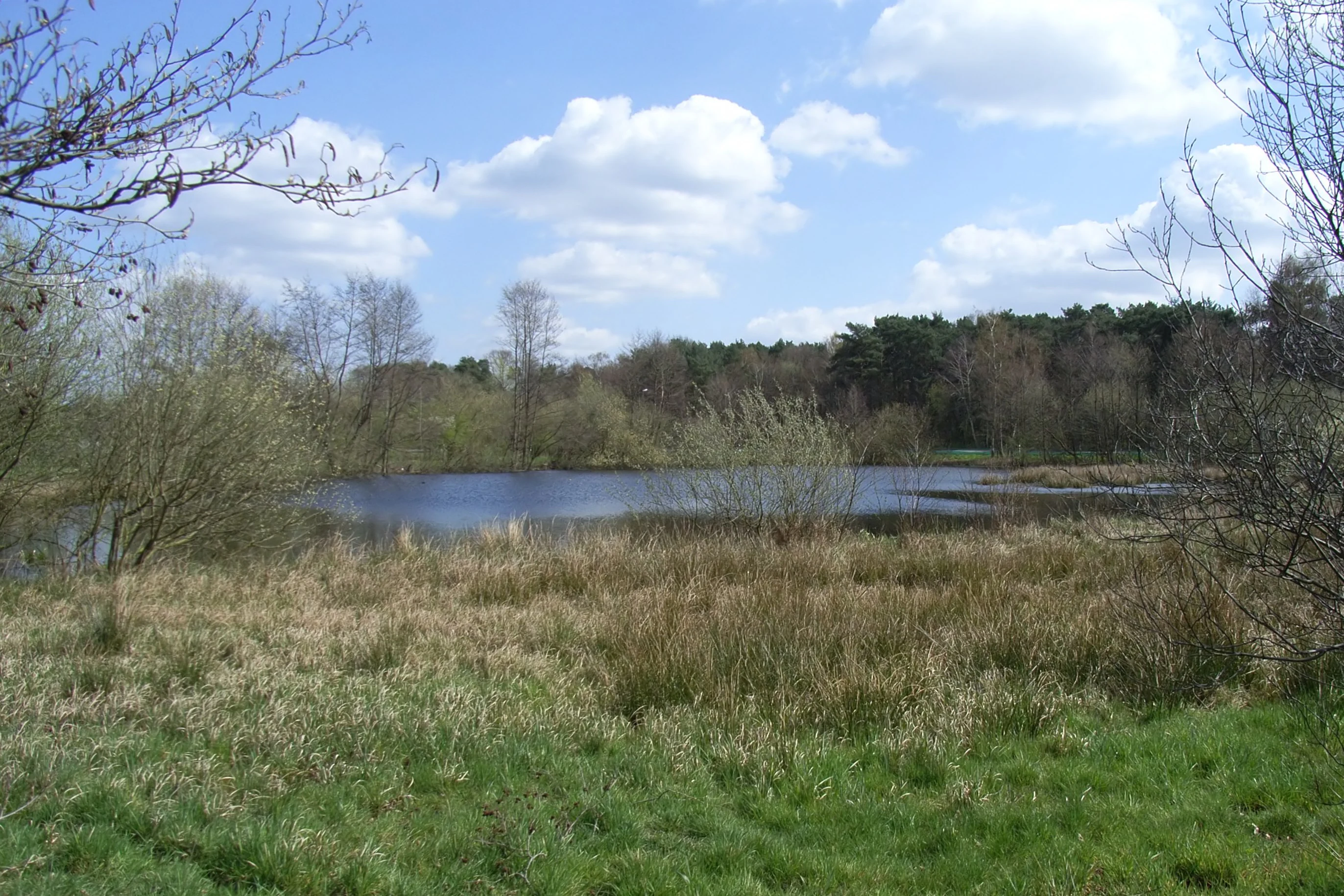
A tranquil pond surrounded by grasses, reeds, and deciduous trees under a blue sky with scattered clouds.
The heath pond at Kampeters Kolk, surrounded by marshy vegetation and forest.

Kampeters Kolk history and protected-area timeline

The pond now known as Kampeters Kolk was already recognized as a natural landmark (Naturdenkmal) as early as 1932, reflecting local appreciation of its distinctive heath pond character and unusual vegetation. Throughout the mid-twentieth century the site drew scientific attention, with detailed plant-community studies published in the 1960s documenting the area's originally species-rich oligotrophic flora.

In 1993 the site was elevated to the status of a formal nature reserve (Naturschutzgebiet) under the designation BI-026, covering roughly two hectares and placing it under the management of the lower landscape authority of the city of Bielefeld. This designation did not, however, halt ongoing ecological deterioration; by the early 2010s local reporting had documented visible declines in water quality and habitat condition. The reserve's history is therefore both a story of early recognition for its ecological distinctiveness and a cautionary example of how nutrient pollution from surrounding land use can overwhelm small protected wetland sites.

Kampeters Kolk landscape and geographic character

Kampeters Kolk sits within the Senne, a broad sandy landscape south of the Teutoburg Forest that today forms part of the city territory of Bielefeld. The reserve's defining landform is a shallow pond occupying a small closed basin, surrounded by a narrow ring of wet meadows, sedge beds, reed zones, and low willow buckthorn shrub thickets. Beyond this wetland fringe, the landscape transitions rapidly into the dry, sandy heath and pine-forest terrain typical of the wider Senne.

The pond itself is artificial in origin: it was created by peat cutting in a small raised bog that had developed in a basin with no natural outflow. This dual character, shaped by both underlying bog hydrology and historical human turf extraction, gives the site a distinctive basin-and-margin topography in which open water, wet meadow, shrub fringe, and upland heath meet within a few tens of meters. The Buschkampstraße borders the pond to the east, while a nearby primary school anchors the site within the local settlement pattern.

Kampeters Kolk ecosystems, habitats, and plant life

The ecological identity of Kampeters Kolk revolves around the interface between open water, acid bog margin, and surrounding heathland. In its mid-twentieth-century state the reserve supported a notable assemblage of oligotrophic specialist plants, including white water lily, marsh gentian, bog bean, cross-leaved heath, cranberry, bog rosemary, round-leaved sundew, narrow-leaved cotton grass, and many-stemmed spike rush. Together these species characterized a nutrient-poor, acidic wetland ecosystem that is now exceptionally rare in the heavily altered Senne landscape.

While the water body itself has shifted through nutrient enrichment away from its original oligotrophic character, the reserve retains structural ecological value through its mosaic of wet meadows, sedge beds, reed stands, and shrub communities. The protected status of the site functions less as a refuge for a complete historical species set and more as a foothold for wetland habitat and amphibian populations within an intensively used region. The presence of the garlic toad as a breeding species illustrates the site's continuing, if reduced, role in supporting Senne wetland fauna.

Kampeters Kolk wildlife and species highlights

From a wildlife perspective, the most consistently highlighted feature of Kampeters Kolk is its role as an amphibian breeding habitat, with the garlic toad documented as a spawning species in the pond. This captures the broader narrative of the reserve as a small wetland refuge embedded in a predominantly dry sandy landscape, where standing water is itself a scarce and valuable resource for amphibians.

Beyond the amphibian interest, the surrounding wet meadows, reed beds, and shrub communities offer shelter and foraging conditions for a range of invertebrate, bird, and small-mammal species typical of wet heath margins. However, the source material does not provide robust documentation of other specific fauna, and so broader detailed wildlife claims are not supported here.

Kampeters Kolk conservation status and protection priorities

Kampeters Kolk is formally protected as a German nature reserve (Naturschutzgebiet), classified at the international level as an IUCN Category IV Habitat/Species Management Area and registered as BI-026 within the North Rhine-Westphalian protected-area system. Its conservation purpose centers on preserving a nutrient-poor heath pond with adjacent wet meadows, sedge communities, reed beds, and willow-buckthorn shrub habitats, along with the rare plant and animal species historically associated with that mosaic.

The site's conservation significance is twofold. It represents one of the few remaining examples of a Senne heath pond landscape, originating from peat cutting in a closed bog basin. And it functions as a working ecological case study: the documentation of species loss, from white water lily, marsh gentian, and bog bean through the latter twentieth century, illustrates how nutrient enrichment from the surrounding catchment can degrade even formally protected wetland sites. Protection here is less about restoring a pristine community and more about slowing further decline and maintaining habitat function for the surviving wetland flora and fauna.

Kampeters Kolk cultural meaning and human context

Locally the site carries the long-standing nickname Rosenteich, a reminder that water lilies once made the pond a familiar scenic feature in the Bielefeld Senne settlement area. The presence of the Georg-Müller-Grundschule Senne school and the Buschkampstraße along its eastern edge also marks Kampeters Kolk as a piece of countryside woven into the daily geography of local residents, rather than a remote wilderness reserve.

Top sights and standout views in Kampeters Kolk

A surviving Senne heath pond reserve of around two hectares, with a basin-and-margin mosaic of wet meadows, sedges, reeds, and willow-buckthorn shrubs. Recognized as a natural monument since 1932 and formally protected since 1993 as nature reserve BI-026, the site offers a compact example of a historically oligotrophic wetland system that continues to support amphibian breeding populations within an otherwise dry sandy landscape.

Best time to visit Kampeters Kolk

Because Kampeters Kolk is a small, ecologically sensitive nature reserve rather than a developed visitor site, the most rewarding visits generally coincide with the warmer months of late spring and summer, when wetland vegetation is most visible and amphibian activity around the pond is most likely to be observable. Early summer in particular can highlight the contrast between the lush wetland margin and the dry sandy Senne heath surrounding it.

Monthly climate preview

Long-term representative monthly averages and temperature ranges for Kampeters Kolk

Kampeters Kolk Climate Normals, Annual Temperature and Precipitation Rhythm

Kampeters Kolk records long-term monthly temperature averages spanning from sub-zero winter minimums to warm summer maximums alongside steady daily precipitation rates. Reviewing the complete twelve-month climatology profile provides deeper analytical context for understanding local environmental conditions.
Annual mean9 °C
1 °C18 °C
Jan
Feb
Mar
Apr
May13°
Jun16°
Jul18°
Aug18°
Sep14°
Oct
Nov
Dec
Warmest month
July

18.1 °C

Coolest month
January

0.5 °C

Wettest month
December

2.6 mm/day

Driest month
April

1.6 mm/day

Park location guide

Geography guide, regional context, and park location map for Kampeters Kolk

Kampeters Kolk park geography, regions, and map view in Germany

Understand where Kampeters Kolk sits in Germany through a broader geographic reading of the surrounding landscape, nearby location context, and its mapped position within the national park landscape.

How Kampeters Kolk fits into Germany

Germany is a federal republic in Western and Central Europe with a population of over 83 million across sixteen constituent states. It is Europe's largest economy by nominal GDP and a major global exporter and importer. The capital is Berlin, and the country borders Denmark, Poland, Czech Republic, Austria, Switzerland, France, Luxembourg, Belgium, and the Netherlands.

Wider geography shaping Kampeters Kolk in Germany

Germany is located in Western and Central Europe, spanning 357,022 km². It borders Denmark to the north, Poland and the Czech Republic to the east, Austria and Switzerland to the south, and France, Luxembourg, Belgium, and the Netherlands to the west. The country has coastlines on the Baltic Sea and North Sea to the north, with the Alps located in the southern region.

Map view of Kampeters Kolk

Use this park location map to pinpoint Kampeters Kolk in Germany, understand its exact geographic position, and read its mapped placement within the surrounding landscape more clearly.

Pigeon | © OpenStreetMap contributors

Location context for Kampeters Kolk

North Rhine-Westphalia

Explore protected wetland terrain, rare acid bog vegetation, and surrounding habitat views.

Kampeters Kolk Photos and Scenery: Visualizing Senne Heath Pond Landscapes

Visual records capture the distinct basin and margin topography of Kampeters Kolk through detailed photography of its central heath pond, wet meadows, and shrub fringes. Examining these protected area views reveals the ecological character and fragile wetland mosaic defining this North Rhine Westphalia nature reserve.

A tranquil pond surrounded by grasses, reeds, and deciduous trees under a blue sky with scattered clouds.

Park atlas

Compare regional wetlands, sandy terrain, and connected nature reserves

Explore Other Parks Near Kampeters Kolk and Surrounding Protected Landscapes

Browsing other protected areas near Kampeters Kolk reveals the broader ecological spread of the surrounding Senne region. Comparing adjacent nature reserves helps place small wetland habitats within a wider network of regional conservation landscapes.
A horizontal watercolor painting showing a small winding river flowing through a lush green forest with soft pink and yellow meadow areas in the foreground.
Nature reserveKreis Gütersloh
About 6.1 km away#1 closest

Southeast

Holter Wald Nature Reserve: Mapping the Protected Woodland and Senne Landscape of Kreis Gütersloh

A major contiguous forest block on the eastern edge of the Westfälische Bucht

Situated in the district of Kreis Gütersloh, Holter Wald is a significant protected area defined by its sandy Senne soils and network of parallel brook valleys. The forest provides a critical lowland habitat for diverse flora and fauna, serving as a rare, large-scale woodland anchor within a largely agricultural region. Explore the terrain characteristics and ecological structure of this key North Rhine Westphalia site.

Area
6.13 km²
Established
2008
IUCN
IV
Relief
Lowland
A watercolor painting of a wetland landscape with soft green hills, trees, and a winding waterway.
Nature reserveNorth Rhine-Westphalia
About 9 km away#2 closest

Southeast

Kipshagener Teiche Nature Reserve: A Protected Wetland Sanctuary in North Rhine-Westphalia

Geographic analysis of historic bogs and managed wetland habitats

Kipshagener Teiche is a small but essential nature reserve in the Senne region, characterized by a distinct mosaic of ponds, transitional bog, and wet heath. Originally protected in 1937, the site serves as a vital record of wetland biodiversity and recovery in western Germany. Its varied topography, featuring dune-based pine plantations and swamp forest, offers a precise look at the intersection of conservation and landscape management in a human-influenced region.

Area
0.113 km²
Established
1970
IUCN
IV
Nature reserveNordrhein-Westfalen
About 13 km away#3 closest

Northeast

Windweheniederung Nature Reserve: Geographic Atlas of an East Westphalian Floodplain

Riparian ecosystems and protected valley land mapping

Windweheniederung represents a specialized nature reserve in Nordrhein-Westfalen that centers on the natural morphology of the Windwehe stream. This protected area provides a critical refuge for wetland-dependent species through its alder-ash woodland and reed-fringed pools. Explore the structural geography of this lowland catchment and understand its role in maintaining functional floodplains amidst a heavily developed regional environment.

Area
0.297 km²
Established
1991
IUCN
IV
Nature reserveNordrhein-Westfalen
About 13 km away#4 closest

Northeast

Windwehetal Nature Reserve: Mapped Protected Brook Valley in Nordrhein-Westfalen

Dynamic stream geography and woodland protected landscapes

Windwehetal represents a compact yet ecologically significant protected area in the German federal state of North Rhine-Westphalia. The reserve showcases near-natural stream dynamics, including undercut slopes reaching three metres, alongside a complex mosaic of gallery woodlands, damp grasslands, and beech forests that define the valley floor and surrounding ridges.

Area
0.565 km²
Established
1998
IUCN
IV
Relief
Upland
Watercolor painting of a green and pink moor landscape with a distant tree line.
Nature reserveNordrhein-Westfalen
About 14 km away#5 closest

West

Hühnermoor Nature Reserve: Geographic Analysis of a Protected Peatland in Nordrhein-Westfalen

A preserved raised-bog landscape and historic botanical refuge

Hühnermoor represents a rare, compact peatland ecosystem situated between ancient sand dunes in the Münsterland region. This nature reserve functions as a critical protected landscape, offering deep insights into regional vegetation history through its stratified peat layers while supporting threatened specialist wetland species.

Area
0.085 km²
Established
1938
IUCN
IV
Relief
Lowland
A horizontal watercolor painting depicting a soft-toned landscape with scattered evergreen trees and undulating, sandy terrain under a light sky.
Nature reserveNordrhein-Westfalen
About 14 km away#6 closest

Southeast

Moosheide Nature Reserve: Mapping the Ancient Inland Dune Landscapes of Nordrhein-Westfalen

Protected heathland and spring-fed habitat geography.

Moosheide provides a focused look at the geomorphology of the western Senne region. This reserve protects some of the oldest inland dunes in northwestern Germany, alongside a rare juxtaposition of dry sandy grasslands and groundwater-dependent stream valleys that support high species diversity.

Area
4.427 km²
Established
1994
IUCN
IV
Relief
Lowland
A soft watercolor painting depicting a marshy wetland with green meadows, tall grasses, and distant rolling hills on a white background.
Nature reserveKreis Gütersloh
About 14 km away#7 closest

Southwest

Im Binner Nature Reserve: Geographic Overview of the Ems Sand Plain Protected Landscape

Mapped wetlands and meadow habitats in Kreis Gütersloh, Germany

Im Binner is a defined nature reserve that anchors a fragment of the historic Ems sand plain ecosystem. This site encompasses a distinctive mix of wet grasslands, shrub-lined boundaries, and converted aquatic habitats, serving as an essential ecological refuge within the intensively farmed lowland geography of North Rhine-Westphalia.

Area
0.3 km²
Established
1988
IUCN
IV
Watercolor painting of a peaceful wetland landscape with green grassy fields, small groups of trees, and a central pond, set against a soft, pale background.
Nature reserveNordrhein-Westfalen
About 16 km away#8 closest

South

Rietberger Emsniederung mit Steinhorster Becken: Geography and Nature Reserve Atlas

Protected floodplain habitats in North Rhine-Westphalia

Situated along the upper Ems river, this protected area serves as an essential ecological corridor. Examine the mapped extent of its wet meadows, basin structures, and riverine channels that distinguish this region from the surrounding agricultural landscape.

Area
9.28 km²
Established
2000
Relief
Lowland
Climate
Temperate

Common questions about visiting, size, designation, and location context for Kampeters Kolk

Kampeters Kolk FAQs for park facts, access, geography, and protected area context

Find quick answers about Kampeters Kolk, including protected-area facts, park geography, trail and visitor context, and how the park fits into its surrounding country and regional landscape.
MoriAtlas Explorer

Continue Your Protected Areas Search Across the Global Atlas

Deepen your exploration by continuing the structured search for national parks and protected areas worldwide. Utilize the comprehensive filtering capabilities to compare different conservation landscapes and refine your understanding of global park geography. Discover more about the distribution and characteristics of protected natural areas.

Global natural geography