Peaks
Góra Ojca
100.6 m

Detailed analysis of lowland terrain, wetland habitats, and mapped landscape features.
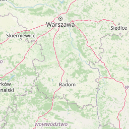
This geographic profile tracks the territorial extent and environmental characteristics of Kampinos National Park in the Masovian Voivodeship of Poland. Covering 385.44 square kilometers, the park encompasses a complex mosaic of temperate forest, inland dunes, riverine systems, and protected wetlands. The structural data provides a focused look at the park's lowland physical geography.
Related tags
Poland's largest forest preserve protecting Europe's finest inland dunes and a stronghold for moose, beavers, and lynx
Kampinos National Park is Poland's second-largest national park and the only one located in the Masovian Voivodeship, situated on the northwestern outskirts of Warsaw. The park encompasses the ancient Kampinos Forest, a vast woodland that is a remnant of the historic Mazovian Forest. Established in 1959 and designated as a UNESCO biosphere reserve in 2000, the park protects a distinctive landscape of sand dunes and wetlands that forms one of Europe's most significant inland dune complexes. The park's protective emblem features the moose, reflecting its importance as one of Poland's three primary locations for this largest member of the deer family. The area holds profound historical significance, with numerous sites commemorating Polish independence struggles and World War II events, including the Palmiry massacre cemetery. The park offers extensive recreational opportunities with over 360 kilometers of hiking trails and 200 kilometers of cycling routes, making it a vital green escape for Warsaw residents and visitors alike.
Country memberships and regional administration data for Poland
Interactive boundary geometry and recorded area metrics
Explore lowland relief classifications and recorded natural features
Peaks
100.6 m
Peaks
89 m
Peaks
93.2 m
Peaks
87 m
Peaks
83.1 m
Peaks
91.5 m
Temperate lowland terrain featuring extensive forest cover, wetlands, and dunes
Forest · Wetland · Dunes · Rivers · Grassland
Temperate coniferous forest · Wetland · Dune habitat · Riverine habitat
Compare regional geography, inland dunes, and connected natural landscapes

West

A vital protected area in Masovian Voivodeship
The landscape of Kampinoski Park Narodowy is defined by the Grochalskie Piachy dune complex and diverse riparian habitats. This atlas entry covers the geological history and protected boundaries of this significant lowland forest, tracing the Vistula river valley's influence on the surrounding terrain and ecological character.
Southwest
Central Polish river valley and reservoir terrain
Examine the territorial boundaries and landscape character of Sulejowski Park Krajobrazowy. This protected area integrates riverine corridors, large reservoir habitats, and mixed lowland forests across the Lodzkie Voivodeship, providing a core reference for understanding the ecological geography of the central Pilica valley.
South
Protected riparian ecosystems and riverine lowland geography
Łąki Ciebłowickie represents an ecologically rich floodplain environment within the Lodzkie Voivodeship. This nature reserve preserves a sequence of vital lowland habitats ranging from marshy meadows to oak-hornbeam forests. Analyze the mapped boundaries and natural terrain features that define this protected riverine mosaic in the heart of central Europe.

North
Geographic analysis of breakthrough valley landscapes and lowland river habitats
This protected area centers on a narrow, gorge-like section of the Wkra River, which cuts through the older land surfaces of the Masovian Voivodeship. The reserve protects vital floodplain forest fragments and demonstrates a clear transition from river-edge alder woodlands to drier plateau slopes, providing a compact example of lowland riverine geomorphology.
Southwest
Floristic reserve and managed coniferous forest geography
Rezerwat przyrody Małecz is a key floristic site in Poland, safeguarding rare Pontic-origin flora and ancient forest stands. This reserve showcases the integration of strict protection zones with moist and dry mixed coniferous forest communities within the Spała Forest District, offering deep insight into regional botanical conservation.
Southwest
Protected fresh mixed forest within the Sulejów Landscape Park context
Rezerwat przyrody Meszcze represents a compact, protected forest block in central Poland. Known for its historical small-leaved lime regeneration, this reserve provides a key case study for forest structure and lowland biodiversity within the Lodzkie Voivodeship, serving as an important part of the Sulejów Landscape Park's protected corridor.

Southeast
A riparian heritage site in the Mazowieckie region
Situated in the Vistula floodplain, Rezerwat przyrody Morysin stands as a significant protected area defined by its massive old-growth trees and layered cultural history. The terrain incorporates diverse wetland features, including the Sobieski Canal and Wilanówka stream, creating a vital habitat for cavity-nesting species and a rare example of integrated natural and historic preservation.

Southwest
Rawka River valley mapping and Puszcza Bolimowska forest terrain
Bolimowski Park Krajobrazowy encompasses a unique mosaic of postglacial plains and riverine ecosystems in central Poland. The area is defined by the Rawka River, which forms a network of meanders, oxbow lakes, and terraces, while surrounding forests retain historical links to the vast primeval woods of Puszcza Bolimowska. This protected territory offers a significant habitat for diverse wildlife, including moose and beaver, within a landscape characterized by its shifting transition between deep forest, wet meadows, and light oak groves.
Deepen your understanding of Kampinos National Park by reviewing the protected area's specific topographic features and ecological context. Use MoriAtlas to map the connections between the dune ridges and forest ecosystems found across this significant Masovian landscape.