

Mori Atlas logo
Nature reserveKattang Nature Reserve

An atlas analysis of protected headlands, eucalyptus woodlands, and coastal heathland biodiversity.

Kattang Nature Reserve: Mapping the Coastal Cliffs and Littoral Landscapes of New South Wales

Kattang Nature Reserve represents a critical protected landscape on the New South Wales Mid North Coast. This atlas entry details the reserve's dramatic geography, defined by the sheer cliffs of Perpendicular Point and a dense mosaic of littoral rainforest, dry eucalyptus woodland, and exposed coastal heathland. Gain insight into the compact environmental transitions that distinguish this area within the broader Australian coastal geography.

coastal reserveheadland cliffslittoral rainforesteucalyptus woodlandheathlandwildflowers

Kattang Nature Reserve

Nature reserve

Park overview

Structured park overview, official facts, and landscape profile for Kattang Nature Reserve

Kattang Nature Reserve park facts, protected area profile, and essential visitor context

Review the core facts for Kattang Nature Reserve, including designation, size, terrain, visitor scale, habitats, and operating context in one park-focused overview.

About Kattang Nature Reserve

Kattang Nature Reserve is a small but ecologically rich coastal reserve on the Mid North Coast of New South Wales, Australia. Located a short distance east of Laurieton and within reach of Port Macquarie, it represents one of several small nature reserves that dot the NSW coastline and protect remnants of the region's natural vegetation in the face of long-standing coastal development.

Beyond its modest size, Kattang stands out for the way it compresses several very different vegetation communities and landforms into one reserve. Within its boundaries the landscape shifts from open coastal headlands and dramatic sea cliffs to sheltered pockets of dry eucalyptus forest, expanses of heathland, and small but ecologically important patches of littoral rainforest. This variety makes the reserve feel larger and more layered than its actual footprint would suggest, and it gives visitors a compressed cross-section of the Mid North Coast's natural environments.

The reserve is managed by the NSW National Parks and Wildlife Service, which oversees a network of similarly small coastal reserves along the New South Wales coast. While Kattang does not have the name recognition of larger nearby parks such as Sea Acres National Park, it is valued for its scenery, its botanical significance, and its appeal as a quiet bushwalking destination. Its proximity to Laurieton and relative ease of access from the Pacific Highway make it a practical destination for visitors exploring the broader coastal landscape between Port Macquarie and the Manning River region.

Kattang's principal drawcard is Perpendicular Point, where the land falls away in steep cliffs to the sea, producing one of the more admired coastal viewpoints in the area. Beyond the headland scenery, the reserve's heathlands and woodlands support a notable wildflower season in the cooler months, drawing naturalists and casual visitors alike.

Quick facts and research context for Kattang Nature Reserve

Kattang Nature Reserve is a small coastal protected area managed by the NSW National Parks and Wildlife Service on the Mid North Coast of New South Wales. Established in March 1984, it covers a compact area near Laurieton, south of Port Macquarie, and protects a dense mosaic of headland, woodland, heathland, and littoral rainforest communities in close proximity to one another.

Protection and recognition

Terrestrial conservation framework and documented protection details

Kattang Nature Reserve Protection Status and Official Designation Facts

Kattang Nature Reserve maintains a documented terrestrial protection scope within its regional conservation framework. Official records compile available designation history, management scope, and statutory recognition standards for the protected area.

Protection details

Protection scope
Terrestrial
Transboundary protection
No
Park context

Deeper park guide and search-rich context for Kattang Nature Reserve

Kattang Nature Reserve history, landscape, wildlife, and travel context

Explore Kattang Nature Reserve through its history, landscape character, ecosystems, wildlife, conservation priorities, cultural context, and seasonal travel timing in a structured park guide built for atlas discovery and search intent.

Why Kattang Nature Reserve stands out

Kattang is best known for the dramatic Perpendicular Point headland, where cliffs descend roughly 40 metres to the sea below, and for the reserve's unusual concentration of vegetation types. Within a very small footprint, it combines exposed coastal headlands, dry eucalyptus woodland, wet and dry heathland, and two surviving patches of littoral rainforest that mirror the better-known rainforest communities of nearby Sea Acres National Park. The reserve is also favored locally for wildflower displays in late winter and early spring, and it is considered a possible habitat for the extremely rare scented acronychia, a rainforest shrub of significant botanical interest.
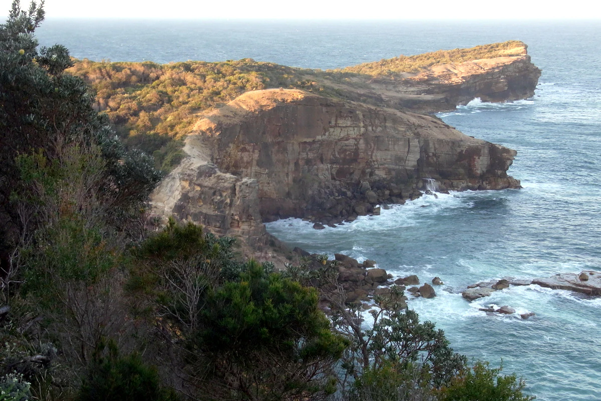
A wide angle view of a rocky headland extending into the ocean with coastal cliffs and scrub vegetation.
Coastal cliffs at Perpendicular Point in Kattang Nature Reserve.

Kattang Nature Reserve history and protected-area timeline

Kattang Nature Reserve was formally established in March 1984, bringing an important block of coastal land on the New South Wales Mid North Coast under formal conservation management by the NSW National Parks and Wildlife Service. The reserve's creation was part of the broader effort during that period to secure surviving patches of native vegetation along the heavily settled New South Wales coastline.

The protected status of the reserve reflects longstanding recognition that the headlands, heath, and forest patches around Laurieton hold botanical communities that have been extensively reduced elsewhere by agriculture and coastal development. By setting aside this compact area, the reserve preserves not only scenic headland but also remnants of local dry eucalyptus woodland and, importantly, two small patches of littoral rainforest that are floristically connected to the larger rainforest communities at nearby Sea Acres National Park.

Kattang Nature Reserve landscape and geographic character

Kattang's landscape is defined by the meeting of land and sea along a deeply indented section of the New South Wales Mid North Coast. The reserve's centerpiece is Perpendicular Point, a bold headland where the land terminates in sheer cliffs rising roughly 40 metres above the Tasman Sea. These cliffs give the reserve its most memorable scenery, with steep drops, exposed rock faces, and the constant presence of ocean spray shaping the vegetation that clings to the cliffs and ledges.

Inland from the headlands, the terrain transitions into a mosaic of more sheltered environments. There are gentle ridgelines and slopes clothed in dry eucalyptus woodland, open expanses of heathland that turn vivid during the wildflower season, and sheltered pockets where moisture and protection allow small patches of littoral rainforest to persist. The compact size of the reserve means these very different landscapes are encountered in close succession, and short walks can move visitors from dramatic coastal cliffs into quiet enclosed forest within a small distance.

Kattang Nature Reserve ecosystems, habitats, and plant life

The natural significance of Kattang Nature Reserve lies in the unusual variety of ecological communities packed into its small area. The reserve protects examples of exposed coastal headland vegetation, dry eucalyptus woodland, wet heathland, dry heathland, and two surviving patches of littoral rainforest, giving it a suite of habitats that would typically be spread across a much larger landscape.

The two littoral rainforest patches at Kattang are particularly important. Although small, they are botanically similar to the rainforest communities at the larger and better-known Sea Acres National Park to the north, and they represent surviving fragments of a vegetation type that once extended more broadly along the New South Wales coast. Concerns about the future of these patches have given the reserve an outsized botanical interest beyond its size.

The heathlands and woodlands of Kattang also support a strong wildflower presence in the cooler months, with the heath communities in particular generating the seasonal floral displays that draw visitors to the reserve each year. There is also ongoing botanical interest in whether the extremely rare scented acronychia grows within the reserve, a possibility that has added to its conservation profile.

Kattang Nature Reserve wildlife and species highlights

The wildlife profile of Kattang Nature Reserve is closely tied to the variety of habitats it protects. The exposed headlands and cliffs provide nesting and perching sites for seabirds and coastal bird species, while the heathlands and eucalyptus woodlands offer habitat for smaller woodland birds, honeyeaters, and a range of insect life associated with the reserve's wildflower displays. The sheltered conditions of the littoral rainforest patches support a different community of birds and invertebrates more typical of moist forest environments.

The reserve is not primarily known as a wildlife-viewing destination in the way that larger Australian parks are, but the combination of coastal, heath, woodland, and rainforest habitats at Kattang creates opportunities to encounter a breadth of fauna well beyond what its small footprint would normally suggest. Local naturalists value the reserve as a place where multiple ecological communities and their associated wildlife can be observed within a single visit.

Kattang Nature Reserve conservation status and protection priorities

Kattang Nature Reserve is a key small-scale conservation holding on the New South Wales Mid North Coast, protecting a compact but unusually rich set of vegetation communities in a region where coastal development, agriculture, and past land clearing have significantly reduced natural habitat. Its formal establishment under the NSW National Parks and Wildlife Service in 1984 recognized the reserve's botanical and landscape values, and it continues to be managed as part of the state's network of coastal reserves.

From a conservation perspective, the reserve's significance is heightened by the presence of two small littoral rainforest patches. These fragments are floristically linked to the rainforest of Sea Acres National Park and represent a vegetation type that is increasingly rare along the New South Wales coast. Protecting these remnants, along with the surrounding heathland and eucalyptus woodland, gives Kattang a botanical conservation value that extends well beyond its modest size.

Top sights and standout views in Kattang Nature Reserve

Kattang Nature Reserve's standout features include the dramatic cliff scenery of Perpendicular Point, where the land drops roughly 40 metres to the Tasman Sea, and the rare presence of two small littoral rainforest patches, which link the reserve botanically to the larger rainforest communities of neighboring Sea Acres National Park. Equally distinctive is the reserve's compact mosaic of headland, eucalyptus woodland, and wet and dry heathland, which together create a layered natural experience usually associated with much larger parks.

The strong wildflower displays in late winter and early spring, combined with accessible bushwalking routes and proximity to Laurieton and Port Macquarie, give the reserve additional appeal as a coastal nature destination on the New South Wales Mid North Coast.

Best time to visit Kattang Nature Reserve

Late winter and early spring are widely regarded as the most rewarding times to experience Kattang Nature Reserve. During these months, the reserve's heathlands produce their strongest displays of wildflowers, the cooler weather makes walking the headland trails more comfortable, and the coastal scenery of Perpendicular Point is particularly clear.

Outside this peak floral season, the reserve remains attractive year-round for those interested in its cliffs, littoral rainforest patches, and varied vegetation communities, though conditions are generally warmer and drier through the summer months.

Monthly climate preview

Long-term representative monthly averages for temperature and precipitation

Kattang Nature Reserve Climate Normals and Annual Temperature Patterns

Representative coordinate records show measured monthly temperature and precipitation normals for Kattang Nature Reserve from 1991 to 2020. Detailed twelve-month climate profiles provide full visibility into long-term meteorological rhythms at this location.
Annual mean20 °C
16 °C24 °C
Jan24°
Feb24°
Mar23°
Apr21°
May19°
Jun17°
Jul16°
Aug17°
Sep18°
Oct20°
Nov21°
Dec23°
Warmest month
February

23.9 °C

Coolest month
July

16.1 °C

Wettest month
February

6.2 mm/day

Driest month
September

1.5 mm/day

Park location guide

Geography guide, regional context, and park location map for Kattang Nature Reserve

Kattang Nature Reserve park geography, regions, and map view in Australia

Understand where Kattang Nature Reserve sits in Australia through a broader geographic reading of the surrounding landscape, nearby location context, and its mapped position within the national park landscape.

How Kattang Nature Reserve fits into Australia

Australia is a constitutional monarchy and federal parliamentary democracy comprising six states and ten territories. With a population of nearly 28 million, it is one of the world's most urbanised countries, with most people concentrated on the eastern seaboard. The country has a high Human Development Index and is known for its cultural diversity, ancient Aboriginal heritage, and unique wildlife.

Wider geography shaping Kattang Nature Reserve in Australia

Australia occupies the entire Australian continent, the island of Tasmania, and numerous smaller islands. It is the world's flattest and driest inhabited continent, featuring vast deserts in the interior (the Outback), tropical rainforests along the eastern coast, and a coastline bordering the Indian and Pacific Oceans.

Map view of Kattang Nature Reserve

Use this park location map to pinpoint Kattang Nature Reserve in Australia, understand its exact geographic position, and read its mapped placement within the surrounding landscape more clearly.

Pigeon | © OpenStreetMap contributors

Location context for Kattang Nature Reserve

New South Wales

Visualizing the dramatic coastal headlands, cliffs, and varied habitats of the New South Wales coast

Kattang Nature Reserve Photos and Scenic Protected Area Landscapes

Visual documentation of Kattang Nature Reserve reveals the striking terrain of Perpendicular Point, where sheer ocean cliffs meet exposed rocky headlands and coastal heath. Studying these protected landscapes helps researchers and visitors understand the rare convergence of eucalyptus woodland and littoral rainforest within a compact coastal reserve.

A wide angle view of a rocky headland extending into the ocean with coastal cliffs and scrub vegetation.

Park atlas

Compare regional geography and connected coastal protected landscapes across the New South Wales coast

Explore Protected Areas and Parks Near Kattang Nature Reserve

Browse nearby national parks and protected areas sharing similar coastal headland and forest terrain. Regional comparison reveals how coastal ecosystems connect across the surrounding landscape.
National parkNew South Wales
About 5.4 km away#1 closest

West

Dooragan National Park: Coastal Mountain Protected Landscape and Old-Growth Forest Atlas

Explore the geography and mapped boundaries of this New South Wales national park.

Dooragan National Park is a significant protected area in New South Wales, renowned for the dramatic North Brother Mountain and its exceptional old-growth blackbutt forests. This park offers a rich exploration of coastal mountain geography, providing valuable mapped landscape context for the Mid North Coast region. Discover the park's unique ecological environment and its role as a protected natural asset.

Area
11 km²
Established
1997
IUCN
II
Relief
Mountain
Marine protected areaNew South Wales
About 6 km away#2 closest

Southeast

Cod Grounds Marine Park: Protected Marine Geography and Submerged Reef Structure

Coastal New South Wales Marine Protected Area

Cod Grounds Marine Park is a compact, four-square-kilometer marine sanctuary located 5.5 kilometers off the New South Wales coast. The area features a distinctive landscape of submerged rocky pinnacles that rise from the flat Manning Shelf, serving as a critical no-take refuge for the grey nurse shark. This site represents a specialized example of temperate reef ecosystem protection within the broader Temperate East Marine Parks Network.

Area
4 km²
Established
2007
IUCN
II
Relief
Lowland
National parkNew South Wales
About 12 km away#3 closest

West

Middle Brother National Park: New South Wales Protected Area and Geographic Exploration

Mapped boundaries and regional landscape context for this national park.

Middle Brother National Park represents a distinct protected landscape within the state of New South Wales, Australia. This entry offers detailed geographic context, focusing on the park's mapped boundaries and its significance as a national park. Users can explore its place within the regional geography of New South Wales, gaining a structured understanding of this protected area through an atlas-focused perspective.

Area
18.3 km²
Established
1999
IUCN
II
Relief
Mountain
National parkNew South Wales
About 19 km away#4 closest

Northwest

Bago Bluff National Park: New South Wales National Park with Panoramic Views

Explore its mapped geography and protected forest landscapes.

Bago Bluff National Park in New South Wales presents a remarkable protected landscape characterized by its prominent bluff formation, offering breathtaking panoramic views over the Hastings Valley. This national park preserves extensive wet sclerophyll forests and eucalypt woodlands, contributing to a rich mosaic of natural habitats and supporting a vibrant bird population. The park's geography is deeply tied to its geological history, with local quarries revealing significant fossil specimens. As a key protected area, it provides valuable context for understanding the regional landscape and mapped natural terrain of eastern Australia.

Area
40.23 km²
Established
1999
IUCN
II
Relief
Upland
National parkMid North Coast
About 20 km away#5 closest

North

Sea Acres National Park: National Park Protected Landscape and Geographic Atlas

Explore mapped boundaries and regional context.

Sea Acres National Park is a designated national park offering a unique glimpse into Australia's protected natural landscapes. This page provides detailed geographic information, focusing on its mapped boundaries and its setting within the Mid North Coast region. Understand the park's protected landscape characteristics and its contribution to the broader regional geography, enhancing your atlas exploration.

Area
0.76 km²
Established
1987
IUCN
II
Relief
Lowland
National parkNew South Wales
About 23 km away#6 closest

Southwest

Crowdy Bay National Park: New South Wales Protected Coastal Landscape and Terrain Map

Explore mapped boundaries and diverse natural geography within this national park.

Crowdy Bay National Park offers a compelling example of coastal protected landscape in New South Wales, Australia. This page facilitates a detailed atlas exploration of its natural geography, focusing on the interaction between ocean beaches, headlands, and inland forested terrain. Understand the park's specific location and its characteristic ecosystems, providing a structured view of this significant national park for geographic discovery.

Area
102 km²
Established
1972
IUCN
II
Relief
Lowland
National parkNew South Wales
About 29 km away#7 closest

West

Coorabakh National Park: A Protected Volcanic Landscape in New South Wales

Discover unique terrain, mapped protected boundaries, and regional geography.

Coorabakh National Park in New South Wales, Australia, is characterized by its striking volcanic trio: Big Nellie, Flat Nellie, and Little Nellie. These peaks dominate the rugged escarpment terrain, offering a unique geographic vista. The park protects a rich mosaic of tall eucalypt forests and sheltered subtropical rainforest gullies, highlighting its ecological diversity. For those interested in atlas-style exploration, Coorabakh National Park provides a clear example of a protected landscape with significant geological and ecological features within the broader regional context of New South Wales.

Area
18 km²
Established
1999
IUCN
II
Relief
Highland
National parkNew South Wales
About 36 km away#8 closest

North

Limeburners Creek National Park National Park: Understanding Its Geography and Protected Landscape

Explore mapped boundaries and regional context within New South Wales.

Limeburners Creek National Park is a significant protected area within the geography of New South Wales, Australia. This page offers an in-depth look at its specific landscape, mapped boundaries, and role as a national park. It is structured to support users interested in the detailed geographic context and atlas-level understanding of protected lands, providing a clear view of this entity's natural setting and mapped presence.

Area
91.2 km²
Established
2010
IUCN
II
Relief
Lowland

Common questions about visiting, size, designation, and location context for Kattang Nature Reserve

Kattang Nature Reserve FAQs for park facts, access, geography, and protected area context

Find quick answers about Kattang Nature Reserve, including protected-area facts, park geography, trail and visitor context, and how the park fits into its surrounding country and regional landscape.
MoriAtlas Explorer

Continue Your Protected Areas Search Across the Global Atlas

Deepen your exploration by continuing the structured search for national parks and protected areas worldwide. Utilize the comprehensive filtering capabilities to compare different conservation landscapes and refine your understanding of global park geography. Discover more about the distribution and characteristics of protected natural areas.

Global natural geography