
Mori Atlas logo
Protected areaKeta Lagoon

Mapping the expansive salt marshes, tidal flats, and cultural heritage of this West African coastal system

Keta Lagoon Protected Area and Coastal Wetland Geography in Ghana's Volta Region

Keta Lagoon stands as the largest coastal wetland in Ghana, stretching along the Gulf of Guinea within the Volta Region. This protected area encompasses a complex network of saline open water, mangrove swamps, and floodplains that serve as a critical migratory hub for waterbirds along the East Atlantic Flyway. Beyond its ecological function, the lagoon remains a deeply integrated cultural landscape shaped by centuries of traditional salt winning, fisheries, and the history of the Anlo-Ewe people.

coastal lagoonRamsar wetlandImportant Bird Areamangrove swampfloodplainWest African coast
A flat-design, vector-style illustration of a mountain valley with a waterfall cascading into a winding river, surrounded by trees and a soft sunrise in the background.

Keta Lagoon

Protected area

Park overview

Structured park overview, official facts, and landscape profile for Keta Lagoon

Keta Lagoon park facts, protected area profile, and essential visitor context

Review the core facts for Keta Lagoon, including designation, size, terrain, visitor scale, habitats, and operating context in one park-focused overview.

About Keta Lagoon

Keta Lagoon is a large, shallow coastal lagoon system on the eastern edge of Ghana, in the Volta Region. It is the biggest of more than ninety lagoons distributed along the country's 550-kilometer coastline and runs roughly 126 kilometers along the shore, separated from the Gulf of Guinea by a narrow sandy barrier and backed inland by floodplains, flood-prone farmlands, and extensive mangrove swamps. The combined lagoon and its surrounding wetlands form the Keta Lagoon Ramsar Site, encompassing about 1,200 square kilometers of brackish water, mudflats, mangroves, and seasonally inundated floodplain.

The lagoon's waters are brackish and dynamic, influenced both by seasonal tidal inflow from the Gulf of Guinea and by freshwater streams that drain into it from the north, including the Aka, the Tordzi River, and the Belikpa stream. This mix of salt and fresh water makes the system productive for a wide range of fish and shellfish and gives it its characteristic blend of marine, brackish, and freshwater habitats. Around the lagoon's edge sit towns such as Keta, Anloga, Woe, Kedzi, Anyako, Anlo Afiadenyigba, Denu, and Adina, all of which depend heavily on the water body for transport, food, and income.

Ecologically, the lagoon complex stands out as one of the most important coastal bird areas in West Africa. It supports more than seventy waterbird species, including large populations of migratory waders such as the spotted redshank along the East Atlantic Flyway, as well as curlew sandpiper, little stint, black-winged stilt, white-faced whistling-duck, and several herons and egrets. The combination of shallow feeding areas, sheltered mangrove fringes, and varied tidal flats makes it a critical refueling and wintering site on international migration routes.

At the same time, the lagoon is a working landscape. Fishing, salt production, coconut cultivation, reed harvesting for handicrafts, and boat transport all take place in and around its waters. Traditional Anlo spirituality also remains intertwined with the lagoon, particularly through spiritual associations like Gbele and Mami Wata, and through ritual practices that link catches, rainfall, and community well-being to the behavior of the water body. Designated a Ramsar Wetland in 1992, an Important Bird Area by BirdLife International, and the subject of major coastal defense works in the late twentieth and early twenty-first centuries, Keta Lagoon is now recognized both as a conservation priority and as a vulnerable coastal system under pressure from population growth, erosion, mangrove loss, and climate-driven change.

Quick facts and research context for Keta Lagoon

Keta Lagoon lies in Ghana's Volta Region on the eastern coast, separated from the Gulf of Guinea by a narrow sandbar and bounded on its landward side by floodplains and mangrove swamps. The full Keta Lagoon Ramsar Site covers about 1,200 square kilometers and was designated a Wetland of International Importance under the Ramsar Convention in 1992, with reference number 567. It has also been identified by BirdLife International as an Important Bird Area because of the large numbers of migratory and resident waterbirds it supports.

The lagoon has a tropical savanna climate with a single wet season and a long dry harmattan period. Its waters are brackish, influenced by tidal inflow from the Gulf of Guinea and by freshwater streams including the Aka, Tordzi, and Belikpa, and they support both marine and freshwater fisheries. Keta, Anloga, and a constellation of smaller towns around the lagoon have a combined population of more than ninety thousand, and their economic and cultural lives are deeply interwoven with the water body itself.

Protection and recognition

Documented designation timeline, management scope, and international recognition

Keta Lagoon Protection Status and Terrestrial Conservation History

Keta Lagoon holds a documented terrestrial protection status established in 1992, anchoring its long-term conservation framework. Official records track the designation history and management scope associated with this protected landscape.

Protection details

Protection scope
Terrestrial
Designated year
1992
Transboundary protection
No
Park context

Deeper park guide and search-rich context for Keta Lagoon

Keta Lagoon history, landscape, wildlife, and travel context

Explore Keta Lagoon through its history, landscape character, ecosystems, wildlife, conservation priorities, cultural context, and seasonal travel timing in a structured park guide built for atlas discovery and search intent.

Why Keta Lagoon stands out

Keta Lagoon is best known as Ghana's most important coastal wetland for waterbirds and as the cultural heart of Anlo-Ewe country. It is recognized as the single most significant waterbird site on the entire Ghana coast, supporting over seventy resident and migratory species and an estimated total population of more than one hundred thousand waterbirds, including globally important numbers of several wader species along the East Atlantic Flyway. Equally distinctive is the lagoon's role in the life of the Anlo-Ewe people who settled its shores in the seventeenth century after migrating from Notsie. Traditional spiritual practices, salt-winning during the harmattan, mangrove-based fisheries, and the annual Tagbaza lagoon festival all draw on the water body, and the lagoon complex has come to symbolize both the cultural heritage and the environmental vulnerability of eastern Ghana.
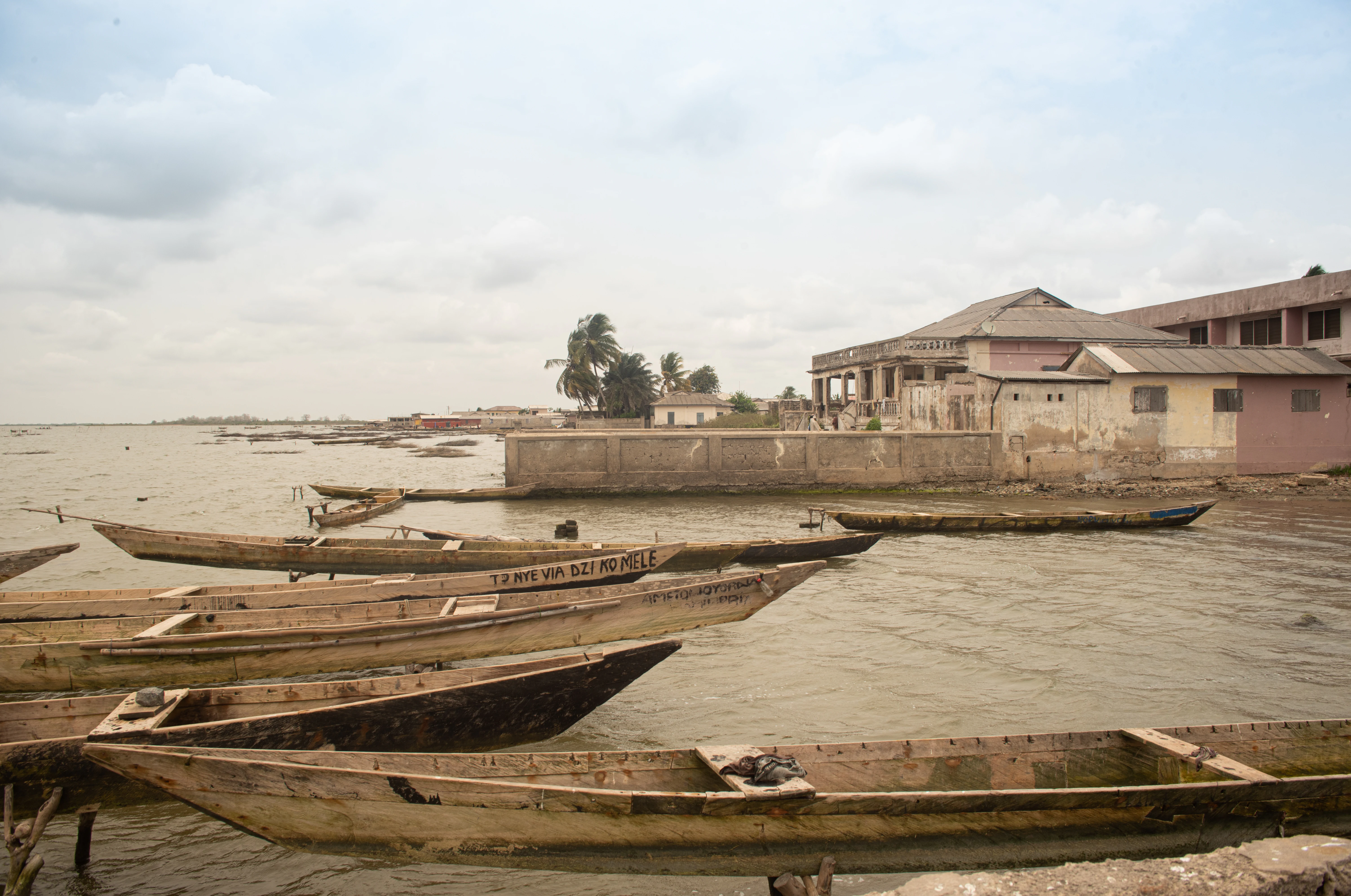
A group of weathered wooden canoes docked in shallow water near buildings on the shore of Keta Lagoon.
Traditional wooden fishing boats moored at the water's edge in Anyako, located within the Keta Lagoon wetland area.

Keta Lagoon history and protected-area timeline

The human history of Keta Lagoon begins with the migration of the Anlo-Ewe people from Notsie in central Togo in the mid-seventeenth century. After settling first at Anloga, these groups spread along the shores of the lagoon, establishing a network of small towns and villages that collectively framed the water body as the center of everyday life in Anlo land. Over time, fishing, salt-winning, boat building, and trade turned the lagoon into the economic backbone of the region.

Colonial administrators began systematic recording of high water levels at Keta from 1907 onward, when floods periodically displaced whole communities. Despite repeated appeals from local merchants and residents, the colonial government largely left responsibility for flood and erosion control to the inhabitants themselves, and the question of whose duty it was to protect the coast became a defining theme in Anlo-Ewe political life. Early attempts at coastal engineering, including a 1963 canal cut by Aryee of the Public Works Department, failed when the structure was swept away in a major flood. Salt production on the lagoon, meanwhile, expanded from the early eighteenth century into a major economic activity tied to the harmattan dry season.

In the modern era, restoration, conservation and a major defense effort reshaped the lagoon. In 1992, the Keta Lagoon complex was inscribed on the list of Wetlands of International Importance under the Ramsar Convention, with reference number 567. The Keta Sea Defence project, begun in 1999, aimed to limit coastal erosion and flooding, including through a canal that allows excess water to drain into the sea and roads built across shallow eastern waters to support construction. BirdLife International designated the lagoon an Important Bird Area, recognizing its global significance for migratory waterbirds. At the same time, traditional spiritual practices and festivals such as Tagbaza continued to mark the lagoon as a living cultural landscape, even as fishing effort, mangrove cutting, and shifting rainfall patterns reshaped its ecology.

Keta Lagoon landscape and geographic character

Keta Lagoon lies within a flat coastal plain in the southeastern corner of Ghana, where a long, narrow sandbar separates the lagoon from the Gulf of Guinea. The sandbar itself is a thin depositional feature shaped by wave and wind action, while inland, the terrain gives way to broad floodplains and tide-influenced lowlands that periodically flood during the wet season. The result is a low-relief, water-dominated landscape in which it is often hard to tell where the lagoon ends and its fringing wetlands begin.

Several small islands punctuate the lagoon. Seva is the best-known inhabited island, with a small community linked to the mainland by a road through the water to Konu. Further afield are Dudu, uninhabited, and Netivi Kpota, known for its coconut trees. The shoreline itself is fringed in many places by mangrove swamps, especially along quieter northern and western edges, while the eastern side is increasingly shaped by the Keta Sea Defence infrastructure, including canals, embankments, and access roads built across shallow parts of the lagoon.

The broader regional context suggests that the lagoon basin is geologically young. Some scientists theorize that it was formed when ancient seas receded, leaving behind a sandy coastline; others argue that it marks the bed of a former, much larger river system; and a third theory points to it as the remnant of freshwater ponds created by melting ice during past climatic shifts. Whatever the precise origin, the lagoon's present character combines sandy beaches, saline open water, muddy tidal flats, and mangroves, creating a richly textured coastal wetland landscape.
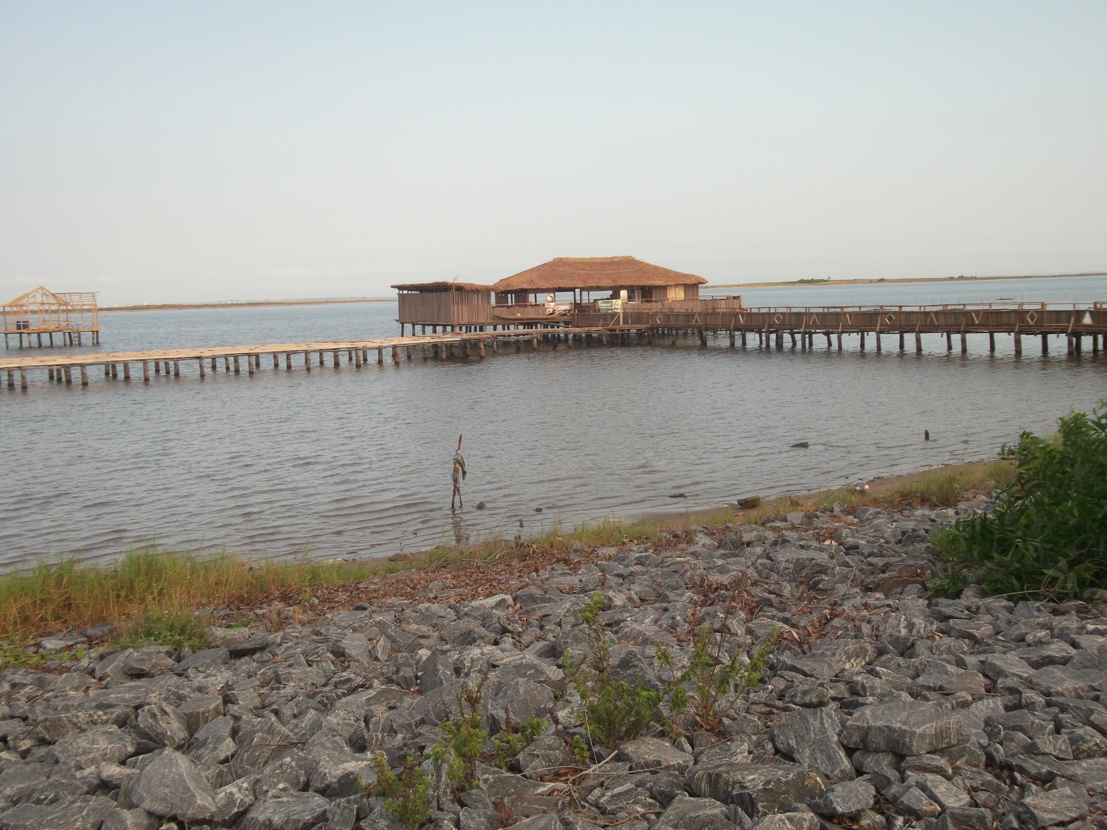
A long wooden pier with a roofed structure at its end stretches out over the calm water of Keta Lagoon, with a rocky shoreline in the foreground.
A wooden pier extending into the waters of Keta Lagoon, with a sheltered structure at the end.

Keta Lagoon ecosystems, habitats, and plant life

The Keta Lagoon complex represents one of the most ecologically diverse coastal wetland systems in West Africa. It blends saline open water, brackish shallows, freshwater inflows, mangrove swamps, and seasonally flooded grasslands, supporting a wide range of aquatic and semi-aquatic life. The mangrove fringe is particularly important, serving as nursery habitat for fish and shrimp and as a structural buffer against coastal erosion.

Vegetation around the lagoon reflects the interplay of salt and fresh water. Red and white mangroves line much of the shore, while raffia palms and aquatic reeds thrive in fresher, less saline margins where rivers enter the lagoon. Coconut trees are common along the coastal strip, and patches of dry coastal vegetation occupy the sandy barrier that separates the lagoon from the sea. Together these plant communities underpin the productivity of the entire system by stabilizing sediments, recycling nutrients, and sheltering juvenile fish.

The lagoon's brackish environment makes it a transition zone between marine and freshwater habitats. Seasonal pulses of marine water through tidal inlets and the engineered canal allow marine fish to enter and breed in calmer inland waters, while rivers such as the Aka and Tordzi deliver fresh water and nutrients from the north. This creates a mosaic of salinity conditions in which marine, brackish, and freshwater species coexist, sustaining a particularly productive but also particularly vulnerable fishery.

Keta Lagoon wildlife and species highlights

Keta Lagoon is recognized as the most important waterbird site on the Ghana coast and one of the most significant coastal bird areas along the Gulf of Guinea. Combined with the nearby Songor Lagoon, it ranks among the four most important waterbird sites on the Gulf of Guinea coast. Surveys have recorded more than seventy species of resident and migratory birds, with an estimated total population of well over one hundred thousand individuals, including globally significant numbers of at least twenty-one species.

The lagoon is especially important for migratory waders. It supports almost a third of the estimated East Atlantic Flyway population of the spotted redshank, and large numbers of curlew sandpiper, little stint, and black-winged stilt also pass through seasonally. White-faced whistling-duck occurs in sizeable flocks, and several heron and egret species use the shallow margins throughout the year. Key waterbird hotspots include the Fiahor, Woe, Tegbi, Adina, and Afiadenyigba sections of the lagoon.

Fish are the lagoon system, with both freshwater and marine species using its waters for feeding, spawning, and nursery habitat. Freshwater species such as Nile tilapia, redbelly tilapia, and jewel cichlids are present alongside marine visitors including mojarra, halfbeaks, needlefish, juvenile sardines, mullets, and crevalle jacks. The lagoon is also a major habitat for crabs, shrimps, and other crustaceans, both for the wild fishery and for aquaculture supported by the post-Sea Defence dredging and ocean link. Endemic Sarotherodon melanotheron dominates catches in places, reflecting the lagoon's unique brackish-water fish community.

Keta Lagoon conservation status and protection priorities

The Keta Lagoon complex is one of the most important protected coastal wetlands in West Africa. It was designated a Ramsar Wetland of International Importance in 1992 under reference number 567 and has been recognized by BirdLife International as an Important Bird Area. These designations reflect both the lagoon's exceptional birdlife and its broader ecological significance as a mosaic of mangroves, open water, mudflats, and seasonally flooded grasslands.

Despite its protected status, the lagoon faces serious conservation pressures. Large areas of red and white mangrove have been cut for fuelwood and to make way for salt pans, undermining spawning, breeding, and feeding sites for fish and reducing the system's resilience to erosion. Overfishing, including the use of small mesh nets, has altered the size structure and species composition of catches, while pollution from domestic waste and habitat degradation further stress the ecosystem.

The Keta Sea Defence project, begun in 1999, has reshaped the conservation picture by reopening a controlled link between the lagoon and the sea, allowing floodwater to drain more effectively and shrimps to access lagoon habitat. This has helped restore some economic value to the fishery, even as it raised new concerns about salinity changes and interrupted sediment flows. Local fishing restrictions, including bans on fishing on certain days, reflect community-level attempts to manage catches sustainably, while calls from national figures and local leaders have highlighted the continuing need to protect the lagoon from garbage dumping, harmful fishing chemicals, and overextraction of its natural resources.

Keta Lagoon cultural meaning and human context

Keta Lagoon is at the center of Anlo-Ewe cultural life. The Anlo state formed when Ewe migrants from Notsie in central Togo settled first at Anloga in the seventeenth century and then expanded along the lagoon's shores, creating a network of towns tied together by the water body. Over generations, the lagoon has shaped language, customs, livelihoods, and political identity in Anlo land, and it remains a powerful symbol of community belonging.

Traditional spiritual practices remain closely tied to the lagoon. Practitioners of the Anlo belief system hold that the lagoon is inhabited by spirits who must be honored to ensure good catches. Rituals at sites such as Gbele near Anlo Afiadenyigba, including the ceremonial offering of livestock to the water, are still performed. The Bate Clan maintains a relationship with Mama Bate, a sea Orisha linked to Mami Wata, and explains the historical expansion of land around Keta through this spiritual bond.

Festivals, dances, and oral traditions keep the lagoon's cultural role alive. The annual Tagbaza, or Lagoon Festival, organized by chiefs and people of Anlo Afiadenyigba, brings communities together to celebrate and reflect on the health of the water body. Traditional dances such as agbadza, gahu, atsiagbekor, babasiko, and misago draw on the rhythms of lagoon life, while the economic practices that surround the water, from salt-winning to net-making and boat-building, form a craft heritage passed down through generations. At the same time, intergenerational change is gradually reshaping these traditions, as younger fishermen increasingly explain declining catches through ecological rather than spiritual causes.

Top sights and standout views in Keta Lagoon

Keta Lagoon stands out for the sheer scale of its open water, its importance as a hub of Anlo-Ewe life, and its global value for migratory waterbirds. It is the single most important waterbird site on Ghana's coast and one of the four most important along the Gulf of Guinea, supporting more than seventy species and an estimated population of over one hundred thousand birds, including exceptional numbers of spotted redshank and other waders on the East Atlantic Flyway.

The lagoon also stands out for the depth of its cultural imprint. Salt-winning during the harmattan, mangrove-based fishing, traditional boat-building, and spiritual rituals all remain part of the working life of the lagoon, while festivals like Tagbaza reinforce its identity as a living cultural landscape. As a Ramsar Wetland, an Important Bird Area, and a long-contested site of coastal defense and environmental management, it offers a rare combination of ecological, economic, and cultural significance along the West African coast.

Best time to visit Keta Lagoon

The character of a visit to Keta Lagoon is shaped by the contrast between the wet and dry seasons on Ghana's eastern coast. During the wet season, from roughly May through October, the lagoon and its floodplains swell with rainfall and river inflow, creating expansive muddy margins that are particularly rich for waterbirds and visually dramatic for travelers interested in wetland scenery. Heavy rain and periodic flooding can, however, make low-lying roads and villages harder to access.

The harmattan dry season, from November into February, transforms the lagoon into a different landscape. Shallower parts of the lagoon close to towns such as Adina, Afiadenyigba, and Anyako evaporate under dry winds, leaving salt pans where communities harvest crystals in a practice that has been part of local life for centuries. Birding remains rewarding throughout, but the cooler, dustier harmattan air gives the lagoon a calmer, more contemplative atmosphere, well suited to cultural visits, festival attendance, and exploration of the various fishing towns that ring the shore.
Monthly climate preview

Long-term representative temperature and precipitation patterns across the annual cycle

Keta Lagoon Climate Normals and Measured Monthly Temperature Rhythms

Historical NASA Power records for Keta Lagoon reveal sustained warmth and distinct monthly precipitation variations across a representative coordinate. Reviewing the complete twelve-month climatology provides deeper insight into measured long-term temperature ranges and precipitation shifts.
Annual mean27 °C
25 °C29 °C
Jan28°
Feb29°
Mar28°
Apr28°
May27°
Jun26°
Jul25°
Aug25°
Sep26°
Oct26°
Nov27°
Dec28°
Warmest month
February

28.7 °C

Coolest month
August

24.8 °C

Wettest month
June

5.7 mm/day

Driest month
January

0.5 mm/day

Park location guide

Geography guide, regional context, and park location map for Keta Lagoon

Keta Lagoon park geography, regions, and map view in Ghana

Understand where Keta Lagoon sits in Ghana through a broader geographic reading of the surrounding landscape, nearby location context, and its mapped position within the national park landscape.

How Keta Lagoon fits into Ghana

Ghana, officially the Republic of Ghana, is a West African nation spanning approximately 240,000 km² along the Gulf of Guinea. It achieved independence from Britain in 1957, becoming the first Sub-Saharan colony to do so, and transitioned to a republic in 1960. The country has a population of over 35 million, with Accra as its capital and largest city. Ghana features diverse ecosystems from coastal savannas to tropical rainforests and is linguistically and ethnically rich, with English as the official language.

Wider geography shaping Keta Lagoon in Ghana

Ghana is located in West Africa along the Gulf of Guinea and Atlantic Ocean to its south. It borders Côte d'Ivoire to the west, Burkina Faso to the north, and Togo to the east. The country spans diverse ecologies including coastal savannas and tropical rainforests.

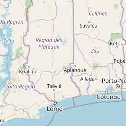
Map view of Keta Lagoon

Use this park location map to pinpoint Keta Lagoon in Ghana, understand its exact geographic position, and read its mapped placement within the surrounding landscape more clearly.

Pigeon | © OpenStreetMap contributors

Location context for Keta Lagoon

Volta Region

Explore protected area views, mangrove habitats, and waterbird environments across the lagoon.

Keta Lagoon Photos and Scenery: Visualizing Ghana Coastal Wetland Landscapes

Visual documentation reveals the distinctive terrain, open water expanses, and tidal flats that define this protected coastal wetland environment. Examining photographic records helps researchers and visitors understand the complex topography and ecological character of the region more clearly.

A group of weathered wooden canoes docked in shallow water near buildings on the shore of Keta Lagoon.

A series of wooden buildings with thatched roofs built on stilts over calm lagoon water under a pale sky.

A long wooden pier with a roofed structure at its end stretches out over the calm water of Keta Lagoon, with a rocky shoreline in the foreground.

Park atlas

Compare adjacent wetland reserves, coastal lagoons, and regional habitats

Explore Protected Areas Near Keta Lagoon and Surrounding Coastal Wetlands

Browse nearby protected landscapes and coastal ecosystems following a visit to Keta Lagoon. Expanding the search helps contextualize regional waterbird habitats and wetland geography.
Wildlife reserveVolta Region
About 76 km away#1 closest

Northwest

Kalakpa Game Production Reserve: Atlas Overview of Protected Terrain in Ghana

Ecological mosaic landscape in the Volta Region

Kalakpa Game Production Reserve represents a diverse protected area where Borassus and Combretum woodlands meet semi-deciduous gallery forests. Situated on the foothills of the Togo Mountains, this reserve provides essential habitat in the forest-savanna transition of southeastern Ghana, defined by its rugged rocky hills and seasonal valley streams.

Area
320 km²
Established
1975
IUCN
VI
Relief
Upland
Wildlife reserveGreater Accra Region
About 98 km away#2 closest

West

Sakumo Ramsar Site Wildlife Reserve: Geographic and Protected Landscape Overview

Coastal lagoon and savanna wetland within the Greater Accra Region

Located along the southern coast of Ghana, the Sakumo Ramsar Site functions as a unique wildlife reserve where a seasonally shifting lagoon meets freshwater marshes and coastal savanna. This map-focused profile examines the ecological boundaries and terrain features of this significant wetland, which serves as a vital sanctuary for migratory birds despite its position within the dense urban fabric of the Accra-Tema metropolitan area.

Area
14 km²
Established
1992
Relief
Lowland
Climate
Tropical
A horizontal watercolor painting depicting a winding river flowing through a lush green landscape with distant hills under a light sky.
Biosphere reserveBenin
About 101 km away#3 closest

Northeast

Mono Transboundary Biosphere Reserve: Mapped Protected Landscapes and Regional Geography

Coastal river deltas, wetlands, and savanna transition zones

The Mono Transboundary Biosphere Reserve preserves a critical intersection of freshwater river systems and marine coastal environments. Stretching along the border of Benin and Togo, this protected area includes expansive mangroves, lagoons, and floodplains that transition into inland savanna. The geography of the reserve reflects a dynamic interface between land and water, encompassing a range of natural terrain that supports both ecological conservation and integrated regional land use.

Area
3,462.85 km²
Established
2017
Relief
Lowland
Climate
Tropical
Wildlife reserveVolta Region
About 123 km away#4 closest

Northwest

Tafi Atome Monkey Sanctuary: Mapping Ghana's Community Protected Wildlife Reserves

Protected sacred grove geography in the Volta Region

Tafi Atome Monkey Sanctuary preserves a unique tropical forest ecosystem that has been protected by local tradition for over two centuries. Located in the Volta Region of Ghana, this wildlife reserve demonstrates the significance of community-based conservation. View the sanctuary through the lens of its forest structure, primate populations, and the surrounding rural mosaic that makes this site a key element of the region's protected landscape.

Established
1993
Relief
Lowland
Climate
Tropical
Access
Access unknown
A horizontal watercolor painting showing a winding river flowing through a lush marshy landscape with distant hills in the background.
Nature reserveGreater Accra Region
About 127 km away#5 closest

West

Densu Delta Ramsar Site: Coastal Wetland Geography in the Greater Accra Region

Protected nature reserve, lagoon network, and tidal marshland

Located at the mouth of the Densu River, this Ramsar site features an interconnected system of mangroves, salt pans, and shallow lagoons. The protected area serves as an essential coastal buffer and bird habitat, showcasing the complex interplay between riverine freshwater and the marine environment of the Gulf of Guinea.

Area
58.93 km²
Established
1992
Water
Water-dominated
Protected areaOuémé
About 140 km away#6 closest

Northeast

Basse vallée de l'Ouémé, lagune de Porto-Novo, lac Nokoué: Benin Wetland and Protected Area

Geographic analysis of a major West African riverine and lagoon system

Spanning the lower reaches of the Ouémé River, this protected wetland area in southern Benin integrates complex fluvial and coastal landscapes. The territory includes Lake Nokoué and the Porto-Novo lagoon, creating a vital hydrological basin that supports seasonal floodplains, mangrove fringes, and significant ecological connectivity. Examine the mapped boundaries and natural terrain of this unique West African environmental corridor.

Area
916 km²
Relief
Lowland
Climate
Tropical
Access
Access unknown
Wildlife reserveCentral Region
About 170 km away#7 closest

West

Muni-Pomadze Ramsar Site: Protected Coastal Wetlands and Forest Reserves in Ghana

Coastal lagoons, mangrove stands, and undulating hill geography

Covering a compressed sequence of coastal and inland landforms, the Muni-Pomadze Ramsar Site serves as a significant protected landscape. This area encompasses the Muni Lagoon, shoreline dunes, and the forested slopes of the Yenku and Egyasimanku Hills, creating an ecologically diverse habitat that defines the geography of the surrounding coastline.

Area
3 km²
Established
1992
IUCN
II
A horizontal watercolor painting showing a soft, stylized forest landscape with rolling hills, diverse trees, and vegetation in shades of green, yellow, and purple.
Nature reserveAtlantique
About 172 km away#8 closest

Northeast

Forêt relique de Niaouli Nature Reserve: Geography and Protected Landscape Boundaries

A scientific forest refuge in the Atlantique region of southern Benin

The Forêt relique de Niaouli nature reserve covers 220 hectares of protected land, serving as a rare survivor of the semi-deciduous forest that once characterized this part of coastal Benin. This site provides researchers and geography enthusiasts with a deep look into riparian and plateau forest ecosystems. Its ongoing value stems from its long-term ecological data and unique position within the broader West African forest block.

Area
2.2 km²
Established
1997
Relief
Lowland
Climate
Tropical

Common questions about visiting, size, designation, and location context for Keta Lagoon

Keta Lagoon FAQs for park facts, access, geography, and protected area context

Find quick answers about Keta Lagoon, including protected-area facts, park geography, trail and visitor context, and how the park fits into its surrounding country and regional landscape.
MoriAtlas Explorer

Continue Your Protected Areas Search Across the Global Atlas

Deepen your exploration by continuing the structured search for national parks and protected areas worldwide. Utilize the comprehensive filtering capabilities to compare different conservation landscapes and refine your understanding of global park geography. Discover more about the distribution and characteristics of protected natural areas.

Global natural geography