Mori Atlas logo
State or regional parkKhutzeymateen Provincial Park

Mapping the old-growth Sitka spruce forests and critical grizzly bear habitats of the North Coast.

Khutzeymateen Provincial Park: A Protected Coastal Wilderness Sanctuary in British Columbia

(Khutzeymateen/K'tzim-A-Deen Grizzly Sanctuary)

Khutzeymateen Provincial Park preserves a unique coastal landscape at the head of a remote Pacific inlet in British Columbia. This wilderness area functions as a dedicated grizzly bear sanctuary, safeguarding essential salmon-bearing rivers and the largest contiguous stand of old-growth Sitka spruce remaining on Earth. The terrain encompasses steep mountain ridges that descend into a sheltered estuary, creating a rare and undisturbed temperate rainforest ecosystem.

grizzly bear sanctuaryold-growth forestSitka sprucecoastal temperate rainforestestuarysalmon habitat

Khutzeymateen Provincial Park

State or regional park

Park overview

Structured park overview, official facts, and landscape profile for Khutzeymateen Provincial Park

Khutzeymateen Provincial Park park facts, protected area profile, and essential visitor context

Review the core facts for Khutzeymateen Provincial Park, including designation, size, terrain, visitor scale, habitats, and operating context in one park-focused overview.

About Khutzeymateen Provincial Park

Khutzeymateen Provincial Park is a remote, high-conservation-value wilderness area on the North Coast of British Columbia, Canada, stretching from the head of Khutzeymateen Inlet deep into the surrounding Kitimat Ranges. Designated in 1994, it is one of the most ecologically significant protected areas in the province, combining a productive estuarine system, old-growth temperate rainforest, and one of Canada's strongest grizzly bear populations.

The park sits within a network of adjacent protected and conservancy lands, bordered by Ksi X'anmaas Conservancy and the Ksi X'anmas watershed to the north, Khutzeymateen Inlet Conservancy to the west, and Khyex Conservancy along the Khyex River watershed to the south. This broader landscape context matters: grizzlies, salmon, and forest ecosystems do not respect administrative boundaries, and the park's protections are reinforced by the surrounding conservancies that maintain habitat connectivity.

The park's defining feature is its dual ecological identity. On one side is the Khutzeymateen River estuary, described as the first undisturbed estuary of its size to be protected along the British Columbia north coast. On the other is an extensive upland forest dominated by old-growth Sitka spruce, the largest contiguous block of such forest remaining globally. Together, these habitats support salmon runs, coastal brown bears, and a full suite of temperate rainforest species.

Visitor access is deliberately restricted. All arrivals by boat must check in at the K'tzim-a-deen Ranger Station, shore landings are prohibited, and only guided tours of the river estuary and limited controlled wildlife viewing from the inlet are allowed. This tight management reflects both the fragility of the habitat and the park's founding mission: to keep grizzlies and old-growth forest as undisturbed as possible while still allowing careful, low-impact observation.

Quick facts and research context for Khutzeymateen Provincial Park

Khutzeymateen Provincial Park is located on the North Coast of British Columbia, Canada, in the northern Kitimat Ranges at the head of Khutzeymateen Inlet, roughly 37 kilometers northeast of Prince Rupert. It was established by the provincial government on August 15, 1994, and officially opened two days later by Prince Philip, Duke of Edinburgh, alongside 13 Tsimshian hereditary chiefs.

The park combines about 44,588 hectares of upland with around 464 hectares of foreshore within the Khutzeymateen River drainage basin, and protects both estuarine habitat and the largest contiguous stand of old-growth Sitka spruce in the world. It is recognized as the first protected area in Canada created specifically for grizzly bears, and is managed under BC Parks as a Class A provincial park with the dual designation Khutzeymateen/K'tzim-A-Deen Grizzly Sanctuary.

Protection and recognition

Examine the documented conservation framework, management scope, and official designation history.

Khutzeymateen Provincial Park Protection Status and Mapped Designation Records

Khutzeymateen Provincial Park protection status brings together mixed conservation scopes and official designation records for detailed regional analysis. Reviewing these documented management frameworks provides clear insight into the governance context and protected area boundaries.

Protection details

Protection scope
Mixed
Transboundary protection
No
Park context

Deeper park guide and search-rich context for Khutzeymateen Provincial Park

Khutzeymateen Provincial Park history, landscape, wildlife, and travel context

Explore Khutzeymateen Provincial Park through its history, landscape character, ecosystems, wildlife, conservation priorities, cultural context, and seasonal travel timing in a structured park guide built for atlas discovery and search intent.

Why Khutzeymateen Provincial Park stands out

Khutzeymateen is best known as Canada's first grizzly bear sanctuary, a protected area created explicitly to conserve grizzlies and the coastal temperate rainforest habitat on which they depend. The sanctuary's estuary and salmon-bearing rivers provide dense, predictable food sources for bear populations, making it one of the most significant grizzly strongholds in British Columbia. Equally distinctive is the forest itself: Khutzeymateen contains what is described as the largest contiguous stand of old-growth Sitka spruce remaining on the planet, a feature that places the park among the most important temperate rainforest reserves in the world. The combination of intact estuary, old-growth coastal forest, and protected grizzly population gives the park a globally unusual ecological profile.
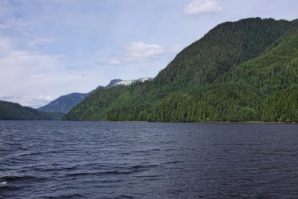
A wide view of a calm inlet with dark water, flanked by steep, forested mountains under a blue sky with light clouds.
The tranquil waters of the Khutzeymateen Inlet, surrounded by dense coastal rainforest and mountain slopes.

Khutzeymateen Provincial Park history and protected-area timeline

The history of Khutzeymateen Provincial Park begins with a threat rather than a celebration. The valley and inlet had been designated for logging when, in 1982, wildlife biologist and conservationist Wayne McCrory received an anonymous tip about a unique, undisturbed valley on British Columbia's northwest coast. Accompanied by bear researchers Stephen Herrero and Ralph Archibald, McCrory visited the inlet in October 1982 and was reportedly overwhelmed by what the team found.

The campaign to protect the area began there. A 300-kilometer hunting ban was established around the inlet, and the provincial government commissioned a study into ways of logging the area without harming grizzlies. Over the following years, researchers worked with Prince Philip, Duke of Edinburgh, then president of the World Wildlife Fund, and with the Lax-kw'alaams First Nation and Coast Tsimshian hereditary chiefs, to build support for formal protection.

The park was established by order-in-council on August 15, 1994, on the advice of Premier Mike Harcourt to Lieutenant Governor David Lam. Two days later, on August 17, 1994, Prince Philip formally opened the sanctuary alongside 13 Tsimshian hereditary chiefs. The park is widely cited as the first protected area in Canada created specifically to safeguard grizzly bears and their habitat.

In 2008, the surrounding Khutzeymateen Inlet Conservancy was established to extend protection of important grizzly intertidal and foreshore habitat, preserve biological diversity, and maintain social, ceremonial, and cultural uses of the area by the Coast Tsimshian. The conservancy addition reflects an ongoing effort to keep the inlet ecosystem intact even as pressures on British Columbia's coastal bears have continued, with grizzlies still lost to poaching, vehicle collisions, and government-sanctioned animal control.

Khutzeymateen Provincial Park landscape and geographic character

Khutzeymateen's landscape is shaped by the meeting of steep coastal mountains and a sheltered Pacific inlet. The park lies in the northern Kitimat Ranges, and its uplands rise sharply from a narrow coastal strip carved by the Khutzeymateen River and its estuary. The terrain combines rugged forested ridges, deeply incised valleys, and a quiet tidal headwater where the river meets the sea.

The inlet itself is a defining landscape feature. Khutzeymateen Inlet penetrates far inland, creating a buffered environment where freshwater and saltwater systems overlap in an unusually intact estuarine complex. The protected foreshore, although small in total area compared with the surrounding uplands, is critical because it forms the productive edge where salmon, bears, and coastal forest ecosystems intersect.

Forests dominate the visible landscape. The uplands hold an extensive, contiguous block of old-growth Sitka spruce, a temperate rainforest environment where mature trees, deep moss layers, and damp understory create a tightly shaded, moisture-rich world. The combination of mountain backdrop, quiet inlet, and ancient forest gives Khutzeymateen a strongly enclosed, almost primeval coastal character very different from open subalpine parks further inland.

Khutzeymateen Provincial Park ecosystems, habitats, and plant life

The park's ecological identity is built around the interaction of three systems: a salmon-bearing river and estuary, a coastal temperate rainforest of old-growth Sitka spruce, and the grizzly bear population that depends on both.

The estuary is the ecological engine. Salmon runs moving up the Khutzeymateen River concentrate nutrients in the inlet, feeding bears and a wider food web that includes eagles, wolves, and other scavengers and predators. The park protects the first undisturbed estuary of its size along the British Columbia north coast, which gives the system a level of natural nutrient cycling and shoreline integrity rarely preserved elsewhere in the region.

Behind the estuary, the upland forests grade from spruce-dominated shoreline stands into the broader temperate rainforest of the Kitimat Ranges. The presence of what is described as the largest contiguous block of old-growth Sitka spruce remaining on Earth gives the park a global significance for forest conservation, since these ancient stands support complex understory plant communities, large woody debris systems, and microhabitats used by countless coastal species.

Khutzeymateen Provincial Park wildlife and species highlights

Wildlife at Khutzeymateen is dominated ecologically, culturally, and politically by the grizzly bear. The park was established for grizzlies, and the sanctuary remains one of the most important strongholds for the species on the British Columbia coast. Bears congregate along the estuary during salmon runs, taking advantage of an intact shoreline and undisturbed feeding conditions that are increasingly rare elsewhere.

The same conditions that support bears, salmon-rich inlets, intact estuarine habitat, and extensive old forest, support a broader coastal fauna typical of the North Coast region. This includes scavenging and predatory species drawn to salmon carcasses, wetland and intertidal birds, and forest-dwelling mammals associated with old-growth temperate rainforest. Although detailed species inventories are not the focus of available source material, the park is widely recognized for the density and visibility of its coastal brown bear population during peak salmon season.

Despite the park's protections, the source material notes that dozens of grizzlies in British Columbia are still killed each year by poaching, vehicle collisions, and government-sanctioned animal control, a reminder that even a designated sanctuary does not isolate grizzlies from broader regional pressures.

Khutzeymateen Provincial Park conservation status and protection priorities

Khutzeymateen's conservation significance is unusually direct: the park exists primarily to keep grizzly bears and their habitat intact in an otherwise heavily logged and hunted coastal region. It is recognized as the first protected area in Canada created specifically to safeguard grizzly bears and their habitat, giving it both symbolic and practical importance in the history of North American bear conservation.

The protected area is also a stronghold for old-growth forest. By safeguarding the largest contiguous stand of old-growth Sitka spruce in the world, along with the first undisturbed estuary of its size on the BC north coast, the park preserves elements of the coastal temperate rainforest that have largely been lost elsewhere. The 2008 establishment of the Khutzeymateen Inlet Conservancy further extended these protections into surrounding intertidal and foreshore habitats important to bears.

Conservation management is unusually strict for a provincial park. All access is by boat, visitors must check in at the K'tzim-a-deen Ranger Station, and only guided tours and limited, controlled wildlife viewing from the inlet are permitted; shore landings are prohibited and land use is strictly forbidden. This tightly controlled regime reflects the park's founding principle that ecological integrity, rather than broad public recreation, is the primary conservation objective.

Khutzeymateen Provincial Park cultural meaning and human context

The cultural context of Khutzeymateen is inseparable from the Coast Tsimshian, particularly the Lax-kw'alaams First Nation, whose traditional territory includes the inlet and surrounding watershed. Salmon, the intertidal zone, and the bears that feed on them are central to Tsimshian livelihoods, food systems, and cosmology, and the area continues to hold social, ceremonial, and cultural value.

The 1994 park opening formalized this relationship: Prince Philip opened the sanctuary alongside 13 Tsimshian hereditary chiefs, marking the protected area as a collaborative outcome rather than a top-down designation. The 2008 Khutzeymateen Inlet Conservancy explicitly recognized preservation of social, ceremonial, and cultural uses of the area by the Coast Tsimshian as one of its purposes. The K'tzim-a-Deen name used in the park's official title reflects this ongoing Indigenous place-based identity.

Top sights and standout views in Khutzeymateen Provincial Park

Khutzeymateen's standout features include its status as Canada's first grizzly bear sanctuary, its old-growth Sitka spruce forests described as the largest contiguous stand remaining on Earth, and a protected estuary that is the first undisturbed system of its size along the BC north coast. The park's combination of mammalian megafauna, ancient temperate rainforest, and a tightly restricted access system gives it an unusually direct conservation profile.

Equally distinctive is the partnership history behind the park: a rare alignment of biologists, the Lax-kw'alaams First Nation, and international conservation figures such as Prince Philip producing a protected area designed around wildlife needs rather than recreation. The result is a sanctuary where the experience, for those permitted to enter, is shaped by quiet wildlife observation from the water rather than traditional hiking or camping.

Best time to visit Khutzeymateen Provincial Park

The park's character shifts with the salmon cycle, which is the strongest seasonal signal for any visit. Late spring and summer typically bring the most active bear presence along the estuary, when bears move to the shoreline to feed on out-migrating and returning salmon, making this the period most associated with wildlife viewing opportunities.

Outside the peak salmon months, the inlet's quieter conditions and the muted atmosphere of the temperate rainforest still offer strong scenery value, though wildlife is generally less concentrated. Because access is tightly controlled and weather on the North Coast is often wet and changeable, any visit should be understood as a weather-flexible, marine-based experience shaped primarily by the rhythms of the estuary rather than by conventional summer or winter travel calendars.
Monthly climate preview

Measured long-term temperature ranges and precipitation trends across twelve recorded months.

Khutzeymateen Provincial Park Climate Normals and Annual Weather Patterns

Representative coordinate records show average monthly temperatures ranging from sub-zero winter minimums to mild summer maximums alongside varying daily precipitation rates. Reviewing the complete twelve-month climate profile reveals the full scope of recorded temperature and moisture patterns at this location.
Annual mean5 °C
-3 °C13 °C
Jan-3°
Feb-2°
Mar
Apr
May
Jun10°
Jul13°
Aug13°
Sep10°
Oct
Nov
Dec-2°
Warmest month
August

12.9 °C

Coolest month
January

-2.7 °C

Wettest month
October

9.1 mm/day

Driest month
May

3.6 mm/day

Park location guide

Geography guide, regional context, and park location map for Khutzeymateen Provincial Park

Khutzeymateen Provincial Park park geography, regions, and map view in Canada

Understand where Khutzeymateen Provincial Park sits in Canada through a broader geographic reading of the surrounding landscape, nearby location context, and its mapped position within the national park landscape.

How Khutzeymateen Provincial Park fits into Canada

Canada is a federal parliamentary constitutional monarchy spanning North America from the Atlantic to the Pacific and Arctic Oceans. With a population of over 41 million, it is officially bilingual in English and French at the federal level. The country gained independence from the United Kingdom through a gradual process culminating in 1982.

Wider geography shaping Khutzeymateen Provincial Park in Canada

Canada occupies the northern portion of North America, sharing its longest international border with the United States. The country extends from the Atlantic Ocean to the Pacific Ocean and northward into the Arctic Ocean, giving it the longest coastline of any nation.

Map view of Khutzeymateen Provincial Park

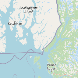
Use this park location map to pinpoint Khutzeymateen Provincial Park in Canada, understand its exact geographic position, and read its mapped placement within the surrounding landscape more clearly.

Pigeon | © OpenStreetMap contributors

Location context for Khutzeymateen Provincial Park

British Columbia

Visual exploration of coastal rainforests, steep mountain ridges, and protected estuaries

Khutzeymateen Provincial Park Photos: Landscapes, Scenery, and Wilderness Views

Visual documentation captures the rugged mountain terrain, ancient Sitka spruce forests, and tidal estuaries that define the protected landscape. Detailed photography reveals the unique coastal character of Canada's premier grizzly bear sanctuary.

A wide view of a calm inlet with dark water, flanked by steep, forested mountains under a blue sky with light clouds.

Park atlas

Compare regional wilderness reserves and coastal temperate rainforest landscapes

Explore Protected Areas and Parks Near Khutzeymateen Provincial Park

Browse neighboring protected areas and wilderness reserves sharing the rugged geography of the British Columbia coast. Continued geographic comparison reveals broader ecological patterns across adjacent coastal mountain ranges and protected river estuaries.
A soft watercolor illustration depicting a calm river scene with evergreen trees, a grassy riverbank, and distant rolling hills in pale green and pink tones.
State or regional parkBritish Columbia
About 45 km away#1 closest

Southeast

Exchamsiks River Provincial Park: Protected Old-Growth Forest Geography in British Columbia

A rare maritime Sitka spruce landscape in the Skeena River estuary

Situated at the meeting of the Exchamsiks and Skeena rivers, this provincial park protects a significant stand of unlogged old-growth coastal rainforest. The terrain provides a compact, ecologically essential example of the temperate habitat characteristic of British Columbia's north coast, featuring moisture-loving spruce and salmonberry understory landscapes.

Area
0.182 km²
Established
1956
Relief
Lowland
Climate
Temperate
A soft watercolor painting of a winding river flowing through a lush, green landscape with forested hills in the background.
Nature reserveBritish Columbia
About 50 km away#2 closest

South

Gamble Creek Ecological Reserve: Protected Nature Reserve Geography and Forest Map

British Columbia North Coast forest and peatland research landscape.

Situated on the North Coast of British Columbia, Gamble Creek Ecological Reserve is a designated nature reserve comprising forest and bog ecosystems. The protected area serves as an important site for studying plant communities, including sphagnum moss and coastal bog species, within a unique altitudinal transition between coastal hemlock and subalpine zones.

Area
10.26 km²
Established
1991
IUCN
Ia
Relief
Mixed relief
A watercolor painting showing a lake, a forested shoreline, and distant mountains in a soft palette.
State or regional parkBritish Columbia
About 52 km away#3 closest

Southwest

Diana Lake Provincial Park: Mapping Coastal Rainforest and Wetland Geography in British Columbia

An examination of North Coast forest and freshwater ecosystems

Diana Lake Provincial Park represents a significant protected area in British Columbia, showcasing the diverse ecological character of the North Coast. The park boundary encompasses a mosaic of old-growth rainforest, open blanket bogs, and freshwater aquatic systems. By protecting these varied terrains, the region maintains vital habitats for Pacific salmon species while providing a structured landscape for understanding the wet maritime environment of the Pacific Northwest.

Area
2.33 km²
Established
1980
IUCN
II
Relief
Upland
Watercolor painting of a coastal scene with green islands, coniferous trees, and soft, hazy mountains in the background, set against a white background.
Marine protected areaBritish Columbia
About 62 km away#4 closest

Southwest

Kitson Island Marine Provincial Park Map and Coastal Protected Area Atlas

Protected island and estuarine landscape in British Columbia

Kitson Island Marine Provincial Park encompasses a vital coastal island and the adjacent Flora Bank at the mouth of the Skeena River. This protected marine environment provides a rare example of accessible sandy beach terrain on the North Coast. Use this atlas resource to understand the park boundaries, island geography, and estuarine interface within the broader Inside Passage conservation network.

Area
0.45 km²
Established
1993
IUCN
II
Relief
Lowland
State or regional parkBritish Columbia
About 66 km away#5 closest

East

Kitsumkalum Provincial Park: Geography and Landscape Atlas of Northern British Columbia

Mapped protected areas and forest terrain in the Skeena region

Kitsumkalum Provincial Park serves as a compact protected node within the mountainous landscape of northern British Columbia. This record details the park's transition from lake to river outlet, the surrounding coniferous forests, and the geographic significance of the Skeena watershed. Gain spatial insight into the park boundaries and the historical context of its shoreline where early homesteading once flourished.

Area
0.4 km²
Established
1946
IUCN
II
Relief
Lowland
A soft watercolor illustration depicting a winding creek bordered by pine forests, with rolling mountains in the background, set against a plain white background.
State or regional parkBritish Columbia
About 89 km away#6 closest

East

Kleanza Creek Provincial Park: Coast Mountains Canyon and Salmon Protected Landscape

Regional protected geography in northwestern British Columbia

Kleanza Creek Provincial Park offers an intimate look at a rugged Coast Mountains landscape. The area is defined by its deep, forested rock canyons and the cascading waters of Kleanza Creek, which serve as essential habitat for spawning pink salmon. This protected site retains historical significance from nineteenth-century placer mining and provides a compact example of the complex terrain found in this part of British Columbia.

Area
2.69 km²
Established
1956
Relief
Mountain
Climate
Temperate
A horizontal watercolor painting showing a calm inlet surrounded by forested hills and distant mountains.
State or regional parkBritish Columbia
About 106 km away#7 closest

South

Klewnuggit Inlet Marine Provincial Park: Regional Geography and Protected Area Mapping

Coastal inlet, freshwater lakes, and northern forest ecosystems.

Klewnuggit Inlet Marine Provincial Park showcases the dramatic meeting of mountain, forest, and sea. Spanning from the sheltered waters of the Grenville Channel to inland freshwater systems, the park offers a detailed study of northern coastal geography, fjord-like marine channels, and diverse bird and marine wildlife habitats.

Area
18 km²
Established
1993
IUCN
II
Relief
Mixed relief
A soft, light watercolor painting of a winding river flowing through a forested valley with distant, muted mountain ranges under a pale sky.
Protected areaBritish Columbia
About 185 km away#8 closest

Southeast

Kitlope Heritage Conservancy: Coastal Temperate Rainforest and Mountain Watersheds

A vast protected area in the Kitimat-Stikine region of British Columbia

Spanning from the Gardner Canal to glaciated inland summits, the Kitlope Heritage Conservancy protects an entire, undisturbed watershed. It is defined by its transition from saltwater fjords through ancient, salmon-bearing river valleys to high granite peaks, acting as a vital benchmark for coastal ecosystem integrity in the Pacific Northwest.

Area
3,220.2 km²
Established
1996
IUCN
Ib
Relief
Mountain

Common questions about visiting, size, designation, and location context for Khutzeymateen Provincial Park

Khutzeymateen Provincial Park FAQs for park facts, access, geography, and protected area context

Find quick answers about Khutzeymateen Provincial Park, including protected-area facts, park geography, trail and visitor context, and how the park fits into its surrounding country and regional landscape.
MoriAtlas Explorer

Continue Your Protected Areas Search Across the Global Atlas

Deepen your exploration by continuing the structured search for national parks and protected areas worldwide. Utilize the comprehensive filtering capabilities to compare different conservation landscapes and refine your understanding of global park geography. Discover more about the distribution and characteristics of protected natural areas.

Global natural geography