Mori Atlas logo
Wildlife reserveKiavah Wilderness

A rare pinyon-juniper ecosystem within the high-desert terrain of Kern County

Kiavah Wilderness: Mapping the Protected Scodie Mountains and Mojave Desert Transition

Kiavah Wilderness spans the rugged transitional zone where the southern Sierra Nevada meets the Mojave Desert in Kern County. This protected area features the Scodie Mountains plateau, an abrupt 3,000-foot escarpment, and unique high-desert canyons. By preserving significant pinyon-juniper woodland and critical habitat, the wilderness offers a distinct look at the intersection of high-country terrain and arid desert landforms.

Mojave DesertSierra NevadaScodie MountainsWilderness areaPinyon-juniper woodlandDesert wildflowers

Kiavah Wilderness

Wildlife reserve

Park overview

Structured park overview, official facts, and landscape profile for Kiavah Wilderness

Kiavah Wilderness park facts, protected area profile, and essential visitor context

Review the core facts for Kiavah Wilderness, including designation, size, terrain, visitor scale, habitats, and operating context in one park-focused overview.

About Kiavah Wilderness

Kiavah Wilderness occupies one of the most ecologically distinctive corners of California's desert country. The protected area lies in Kern County, west of the small town of Inyokern and roughly 50 miles northeast of Bakersfield, with the town of Lake Isabella to the west reached by California State Route 178, the same route that climbs over Walker Pass at the northern boundary of the wilderness. From there, the landscape drops into the Scodie Mountains and onto a broad plateau that is simultaneously part of the southern Sierra Nevada and the Mojave Desert.

At the heart of Kiavah are the Scodie Mountains, with Skinner Peak reaching 7,073 feet in the south and Pinyon Peak reaching 6,768 feet in the north. The plateau is incised by a network of canyons and broken by alluvial fans and bajadas, while the northern edge rises in a sharp 3,000-foot escarpment that gives the area a strong sense of relief for such a compressed wilderness. Three better-known seasonal springs, Yellowjacket, McIvers, and Willow Springs, emerge from the plateau's slopes, with additional seeps scattered through folded canyon floors.

What makes Kiavah especially significant is the unusual overlap of ecosystems that converge here. The wilderness supports a substantial pinyon-juniper woodland, one of only two significant protected examples of this habitat type in California, layered with Mojave Desert species and Sierra Nevada edge species. Joshua trees, creosote, sagebrush, Mormon tea, burrobush, and shadscale share the slopes with pinyon pine, juniper, grey pine, and canyon oak. In spring, the desert floors briefly transform with wildflower blooms that typically run from April into June.

Kiavah is also a wildlife refuge in a broader management sense. Although its semiarid conditions and scarce natural water limit wildlife numbers, the area includes water developments and artificial springs maintained by the Forest Service to support mule deer, mountain quail, and California quail. It is part of the National Cooperative Land and Wildlife Management Area, the Jawbone–Butterbredt Area of Critical Environmental Concern, and a section of the Pacific Crest Trail, which traverses 17 miles of the wilderness and brings long-distance hikers through its varied terrain.

Quick facts and research context for Kiavah Wilderness

Kiavah Wilderness lies in southern Kern County, California, immediately south of Walker Pass and roughly 50 miles northeast of Bakersfield. Its 88,290 acres straddle the Scodie Mountains and the adjacent Mojave Desert plateau, with terrain that rises above 7,000 feet before dropping steeply to high-desert basins.

The area was federally designated in 1994 under the California Desert Protection Act and is managed cooperatively by the U.S. Forest Service and the Bureau of Land Management, with most of its acreage falling within the Sequoia National Forest. It sits within the National Cooperative Land and Wildlife Management Area and forms part of the Jawbone–Butterbredt Area of Critical Environmental Concern.

Protection and recognition

Examine terrestrial protection scope and recognized conservation history

Kiavah Wilderness Protection Status and Official Designation Records

Kiavah Wilderness maintains a documented terrestrial protection scope within official conservation frameworks. Official records organize designated management details and recognition status for this protected natural area.

Protection details

Protection scope
Terrestrial
Transboundary protection
No
Park context

Deeper park guide and search-rich context for Kiavah Wilderness

Kiavah Wilderness history, landscape, wildlife, and travel context

Explore Kiavah Wilderness through its history, landscape character, ecosystems, wildlife, conservation priorities, cultural context, and seasonal travel timing in a structured park guide built for atlas discovery and search intent.

Why Kiavah Wilderness stands out

Kiavah Wilderness is best known as one of only two protected areas in California supporting a significant pinyon-juniper woodland, set within the dramatic ecological transition between the southern Sierra Nevada and the Mojave Desert. The Scodie Mountains plateau, with its abrupt 3,000-foot escarpment, seasonal springs, and weathered canyons, defines the visual character of the wilderness. The area is also recognized for the Walker Pass milkvetch, a rare and endemic wildflower known from very few populations, all located in Kern County. Its location along a 17-mile stretch of the Pacific Crest Trail, combined with its joint Forest Service and BLM management, gives Kiavah both an ecological and a long-distance hiking identity.
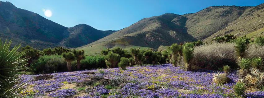
A wide, sunny landscape view of a purple wildflower field in the foreground, with scattered desert shrubs, Joshua trees, and large, arid mountains under a clear sky in the background.
A vibrant field of purple wildflowers blooming in the Kiavah Wilderness with the Scodie Mountains in the background.

Kiavah Wilderness history and protected-area timeline

Kiavah Wilderness was formally established in 1994 as part of the California Desert Protection Act, signed into law as Public Law 103–433. The act was a major federal effort to strengthen protections for the desert landscapes of southeastern California, redesignating existing lands and elevating large tracts of public land into permanent wilderness status.

Before and after this federal designation, the area's lands were administered primarily by the U.S. Forest Service, particularly as part of the Sequoia National Forest, and the Bureau of Land Management. Today, the two agencies jointly manage Kiavah, recognizing both the forest character of its uplands and the desert character of its bajadas and basins. The wilderness also forms part of the National Cooperative Land and Wildlife Management Area and the BLM's Jawbone–Butterbredt Area of Critical Environmental Concern, signaling that management of the area goes back beyond its wilderness designation and continues to integrate habitat, wildlife, and cultural values into its protected framework.

Kiavah Wilderness landscape and geographic character

Kiavah Wilderness is defined by the Scodie Mountains, a compact southern spur of the Sierra Nevada that rises as a broad plateau above the Mojave Desert. The plateau is split by the rugged topography of the Scodies themselves, with Skinner Peak at 7,073 feet forming the high point in the south and Pinyon Peak at 6,768 feet anchoring the north.

The terrain is heavily shaped by erosion and time. Deep canyons cut the flanks of the plateau in most directions, while the northern face falls away in a 3,000-foot escarpment that creates an abrupt transition between high country and desert lowland. Across the base of the mountains, classic Mojave landforms take over: weathered alluvial fans, bajadas, dry washes, and scattered rocky ridges that characterize the larger desert setting.

Water, though scarce, is a defining feature of the landscape. Three named seasonal springs, Yellowjacket, McIvers, and Willow Springs, emerge from the slopes of the plateau, and other seeps appear in the folds of various canyons. These small, concentrated pockets of moisture create narrow oasis-like ribbons of vegetation that stand out against the otherwise austere backdrop. Walker Pass, the historic crossing point of the southern Sierra Nevada, marks the northern boundary of the wilderness and gives the area one of its most recognizable geographic landmarks.

Kiavah Wilderness ecosystems, habitats, and plant life

The ecological story of Kiavah Wilderness is one of blend and overlap rather than separation. Because the area sits directly between the southern Sierra Nevada and the Mojave Desert, it captures species and habitat types from both regions in a single protected landscape, producing plant and animal communities that are uncommon elsewhere in California.

The most distinctive natural feature of Kiavah is its extensive pinyon-juniper woodland. The wilderness is one of only two protected areas in the state that supports a significant stand of this woodland type, where pinyon pine and juniper intermingle with grey pine and canyon oak on the mid-elevations. Below these woodlands, the vegetation shifts into more familiar Mojave Desert communities, with creosote, sagebrush, Mormon tea, burrobush, and shadscale dominating the lower bajadas, and Joshua trees scattered along the margins.

A particularly notable feature of Kiavah's ecology is the Walker Pass milkvetch, a rare and endemic wildflower in the pea family. It was first described in 1987 from a collection made near a newly constructed section of the Pacific Crest Trail, and today fewer than ten known populations survive, all within Kern County. The species grows in sandy to loamy and granitic soils beneath pinyon pines and canyon live oaks, on west-facing slopes between roughly 5,600 and 6,200 feet. While not formally listed as endangered, it remains one of the most botanically distinctive elements of the wilderness.

Spring is the most visible natural season for vegetation and visitors alike, as ephemeral wildflower displays color the desert floors from April through June before fading back into the surrounding shrub matrix.

Kiavah Wilderness wildlife and species highlights

Wildlife in Kiavah Wilderness is shaped by aridity, elevation range, and the limited availability of natural water. The semiarid climate and the scarcity of reliable springs restrict the abundance and diversity of larger animals, but the mix of woodland, canyon, and desert habitats creates niches for several characteristic species of the southern Sierra Nevada and Mojave Desert transition zone.

Mule deer are among the most visible mammals, and small numbers are supported in part by water developments installed by the U.S. Forest Service to compensate for the lack of natural surface water. Birdlife includes species typical of dry mountains and open desert, with mountain quail and California quail, also known as valley quail, present in the canyons and lower slopes, alongside raptors and passerines such as rough-legged hawk, yellow-headed blackbird, gray-crowned rosy finch, and sage sparrow.

Because of its importance for sensitive desert wildlife, parts of Kiavah fall within the BLM's Jawbone–Butterbredt Area of Critical Environmental Concern, an area designated to protect desert wildlife species and associated habitat values. The wilderness is also part of the National Cooperative Land and Wildlife Management Area, reflecting an integrated management approach in which wildlife habitat protection is a core element alongside wilderness character and recreation management.

Kiavah Wilderness conservation status and protection priorities

Kiavah Wilderness is an important conservation area because it anchors one of the most sensitive transition zones in California's desert and mountain regions. Its combination of pinyon-juniper woodland with classic Mojave Desert shrub communities in a single protected boundary is rare in California, and the area's protected status helps ensure that this combination is preserved from fragmentation, off-road vehicle damage, and habitat degradation.

The wilderness designation itself, made under the California Desert Protection Act in 1994, provides the strongest layer of long-term federal protection. On top of that, much of Kiavah overlaps with the Bureau of Land Management's Jawbone–Butterbredt Area of Critical Environmental Concern, a designation focused specifically on protecting critical desert wildlife and Native American cultural values. The area is also part of the National Cooperative Land and Wildlife Management Area, an arrangement that encourages coordinated management of wildlife resources across agency boundaries.

The presence of the rare Walker Pass milkvetch, known from fewer than ten populations, all in Kern County, gives Kiavah additional conservation weight. Because the plant is not currently listed under state or federal endangered species laws, the wilderness designation itself is a primary safeguard for its long-term survival. Active habitat management, including the installation of water guzzlers and spring improvements to support mule deer and native quail, adds a practical conservation dimension that complements the more passive protection of wilderness status.

Kiavah Wilderness cultural meaning and human context

Kiavah Wilderness sits at a culturally significant crossroads in the southern Sierra Nevada. Walker Pass, which forms part of the northern boundary of the wilderness, has long served as a historical route through the southern Sierra Nevada and remains a recognizable landmark for travelers moving between the Mojave Desert and the San Joaquin Valley.

The region's broader cultural and environmental importance is also reflected in the fact that part of Kiavah lies within the Jawbone–Butterbredt Area of Critical Environmental Concern, where one of the BLM's explicit goals is to protect Native American cultural values alongside wildlife habitat. The presence of historic and prehistoric cultural sites in and around the Scodie Mountains contributes to this wider cultural context, even though detailed site information is not the focus of the wilderness's modern protected status.

Top sights and standout views in Kiavah Wilderness

Kiavah Wilderness's standout features include its position as one of only two protected pinyon-juniper woodlands of significant size in California, set against a dramatic Scodie Mountains backdrop that combines high plateau terrain with a stark 3,000-foot escarpment. The wilderness also stands out for harboring the rare Walker Pass milkvetch, an endemic wildflower known from fewer than ten populations, and for hosting a 17-mile stretch of the Pacific Crest Trail.

Equally distinctive is the area's blend of management and context. Kiavah is jointly managed by the U.S. Forest Service and the Bureau of Land Management, lies mostly within the Sequoia National Forest, and overlaps the Jawbone–Butterbredt Area of Critical Environmental Concern. This layered protection framework reinforces both the wild character and the ecological value of a landscape that bridges the Sierra Nevada and the Mojave Desert.

Best time to visit Kiavah Wilderness

The most rewarding time to experience Kiavah Wilderness visually and ecologically is spring, when the desert slopes light up with wildflower displays that typically run from April into June. This is also the season when the few seasonal springs, including Yellowjacket, McIvers, and Willow Springs, are most likely to be flowing, and when the contrast between the blooming desert floor and the still snow-flecked higher elevations of the Scodie Mountains is most striking.

Outside of spring, the cooler months of fall and early winter are a quieter alternative for hiking and backpacking along the Pacific Crest Trail or the Cholla Canyon Trail, when temperatures are more moderate and the terrain is less exposed to desert heat. Summer visits are possible but tend to be demanding due to the arid conditions and high temperatures typical of the Mojave Desert influences across the lower elevations.

Monthly climate preview

Long-term representative coordinate records for monthly temperature and precipitation variation

Kiavah Wilderness Climate Normals and Representative Annual Temperature Patterns

Kiavah Wilderness records measured representative climate normals featuring distinct annual temperature swings and low baseline precipitation across the monitored coordinate. Reviewing the complete twelve-month dataset clarifies the full range of historical monthly temperature variations and precipitation totals.
Annual mean14 °C
5 °C26 °C
Jan
Feb
Mar
Apr12°
May16°
Jun22°
Jul26°
Aug25°
Sep22°
Oct15°
Nov
Dec
Warmest month
July

26 °C

Coolest month
December

4.9 °C

Wettest month
February

1.6 mm/day

Driest month
June

0.1 mm/day

Park location guide

Geography guide, regional context, and park location map for Kiavah Wilderness

Kiavah Wilderness park geography, regions, and map view in United States of America

Understand where Kiavah Wilderness sits in United States of America through a broader geographic reading of the surrounding landscape, nearby location context, and its mapped position within the national park landscape.

How Kiavah Wilderness fits into United States of America

The United States of America is a federal presidential republic and one of the world's largest countries by area and population. It consists of 50 states across a vast territory spanning multiple time zones, with its capital in Washington, D.C. and largest city in New York City. The nation has a diverse economy, influential political system, and significant cultural and military presence globally.

Wider geography shaping Kiavah Wilderness in United States of America

The United States occupies a vast territory in North America, bordered by Canada to the north and Mexico to the south. The 48 contiguous states stretch from the Atlantic to the Pacific Ocean, while Alaska occupies the northwestern region and Hawaii is an archipelago in the Pacific. The country encompasses diverse terrain including the Rocky Mountains, Appalachian Mountains, Great Plains, and extensive river systems.

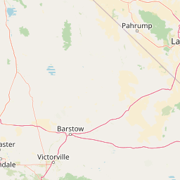
Map view of Kiavah Wilderness

Use this park location map to pinpoint Kiavah Wilderness in United States of America, understand its exact geographic position, and read its mapped placement within the surrounding landscape more clearly.

Pigeon | © OpenStreetMap contributors

Location context for Kiavah Wilderness

CaliforniaKern County
Recorded earthquake history

Review the Historical Earthquake Catalogue for Kiavah Wilderness

Explore the recorded history of seismic events associated by location with the Kiavah Wilderness. This collection provides transparent access to historical data points, allowing for a better understanding of the seismic context near this protected desert landscape.

Kiavah Wilderness Earthquake History

Catalogued events

2,139 events

Strongest magnitude

Magnitude 7.1

Most recent event

Aug 23, 2026

This history includes earthquakes recorded inside the park or within 50 km of its borders

Visual reference guide to the protected terrain, pinyon woodland, and desert habitats.

Kiavah Wilderness Photos and Landscape Scenery Exploration

Visual records capture the rugged topography of the Scodie Mountains and the stark transition zone where the southern Sierra Nevada meets the Mojave Desert. Photographic documentation reveals pinyon juniper woodland, weathered canyons, and high desert landforms across the protected landscape.

A wide, sunny landscape view of a purple wildflower field in the foreground, with scattered desert shrubs, Joshua trees, and large, arid mountains under a clear sky in the background.

Park atlas

Compare regional park geography and adjacent protected landscapes across the southern Sierra Nevada

Explore Protected Areas and Parks Near Kiavah Wilderness and the Surrounding Mojave Transition

Browsing parks near Kiavah Wilderness reveals adjacent protected landscapes spanning the transitional boundary between mountain terrain and desert basins. Regional park comparison connects high-desert ecosystems with surrounding woodland habitats for comprehensive geographic discovery.
Watercolor painting of a panoramic mountain landscape with stylized pine trees and soft green meadows.
Protected landscapeCalifornia
Park boundaries overlap#1 closest

Northwest

Sequoia National Forest: Protected Sierra Nevada Geography and Mountain Terrain

A vast protected landscape spanning 1.1 million acres in California

Spanning Tulare, Kern, and Fresno counties, Sequoia National Forest preserves iconic giant sequoia groves across multiple river watersheds. The terrain features vertical relief exceeding 11,000 feet, showcasing a range of ecosystems from chaparral slopes and coniferous forests to glacial cirques and granite spires located within the southern Sierra Nevada range.

Area
4,829.17 km²
Established
1908
Relief
Mountain
Climate
Mediterranean
A soft watercolor painting of rolling hills and mountain ridges, featuring shades of green, yellow, and faint pink on a white background.
Wildlife reserveCalifornia
0.7 km away#2 closest

North

Domeland Wilderness: Granite Spires and Kern Plateau Geography in the Southern Sierra Nevada

A protected wilderness landscape on the California high plateau

Spanning over 130,000 acres, Domeland Wilderness offers a deep look into the geological transition zone of the southern Sierra Nevada. The protected landscape is characterized by its iconic granite domes and spires, vast summer range meadows for deer, and the winding course of the Wild and Scenic South Fork Kern River. This atlas entry details the rugged terrain, ridge boundaries, and ecological diversity found across this lightly visited high-altitude wilderness.

Area
526.42 km²
Established
1964
IUCN
Ib
Relief
Mountain
A watercolor illustration showing a soft-focused desert landscape with gentle rolling hills, sparse desert vegetation, and muted earthy tones.
Wildlife reserveKern County
8 km away#3 closest

Southeast

El Paso Mountains Wilderness: Geological Atlas and Protected Landscape Overview

Mojave Desert geography within Kern County, California

Explore the volcanic structure of El Paso Mountains Wilderness, a desert landscape dominated by Black Mountain, red buttes, and narrow canyons. This atlas entry details the protected boundary and geological features of this Mojave Desert wildlife reserve, highlighting the intersection of volcanic badlands and ancient archaeological sites.

Area
96.2 km²
Established
1994
IUCN
Ib
Relief
Mountain
A horizontal watercolor painting depicting a mountain range in the background with rolling hills and a winding river or stream in the foreground.
Protected landscapeCalifornia
34 km away#4 closest

North

Inyo National Forest: An Atlas of Protected Landscapes and Sierra Nevada Geography

High altitude wilderness and volcanic terrain in Eastern California

Spanning from the arid Owens Valley floor to the 14,000 foot crest of the Sierra Nevada, Inyo National Forest remains a cornerstone of the American West. This protected landscape contains the Ancient Bristlecone Pine Forest, Mount Whitney, and the Mono Inyo volcanic chain, providing a dense geographic record of glacial, tectonic, and ecological diversity across a vast managed corridor.

Area
7,702.71 km²
Established
1907
IUCN
Ib
Relief
Mountain
Watercolor painting of a mountain landscape with trees in the midground and a simple river or valley floor in the foreground, executed in a soft, light-toned palette.
Protected areaUnited States of America
About 48 km away#5 closest

North

Inyo Mountains Wilderness: Protected Landscapes and Geographic Features in California

A study of fault block terrain and desert mountain ecosystems.

The Inyo Mountains Wilderness serves as a dramatic ecological bridge between the Owens Valley and Saline Valley. This expansive protected area offers a look into late Proterozoic to Cambrian geology and distinct vertical plant zonation. Mapping the range reveals a network of canyons, ridges, and slopes that sustain endemic biodiversity and ancient bristlecone pine stands within the Great Basin periphery.

Area
806.17 km²
Relief
Mountain
Climate
Arid
Access
Remote access
National parkCalifornia
71 km away#6 closest

Northwest

Sequoia National Park National Park: Geographic Identity and Protected Landscape Atlas

Explore mapped boundaries and the terrain of this California protected area.

Gain a structured understanding of Sequoia National Park as a protected landscape, focusing on its mapped geographic boundaries and its context within California. This entry provides foundational data for exploring the park's natural terrain and its role in a broader atlas of conservation lands, ideal for users seeking detailed geographic information.

Area
1,635.19 km²
Established
1890
IUCN
II
Visitors
1.2M annual
National parkCalifornia
78 km away#7 closest

Northeast

Death Valley National Park: Exploring California's Mapped Protected Landscape

View the geographic boundaries and desert terrain.

Access a detailed atlas perspective of Death Valley National Park, a protected national park situated in California. Understand the park's distinct mapped boundaries and its role within the regional geography. This resource highlights the unique desert landscape, offering focused insights into its protected-area identity and natural terrain for geographic discovery.

Area
13,848.4 km²
Established
1994
IUCN
II
Visitors
1.1M annual
A watercolor painting showing a panoramic view of mountain ranges, a treeline, and a calm body of water in the foreground.
Wildlife reserveCalifornia
81 km away#8 closest

North

John Muir Wilderness: Sierra Nevada Protected Landscape and High Mountain Geography

California wilderness area with glacial basins and granite peaks

John Muir Wilderness represents one of the largest protected high-elevation areas in the contiguous United States. Spanning the Sierra Nevada crest, its granite terrain is sculpted by Pleistocene glaciation into sharp arêtes, deep canyons, and hundreds of alpine lakes. This wilderness serves as a vital geographic anchor for mountain ecosystems, offering an extensive look at the high-country landscape of eastern California.

Area
2,641.76 km²
Established
1964
IUCN
Ib
Relief
Mountain

Common questions about visiting, size, designation, and location context for Kiavah Wilderness

Kiavah Wilderness FAQs for park facts, access, geography, and protected area context

Find quick answers about Kiavah Wilderness, including protected-area facts, park geography, trail and visitor context, and how the park fits into its surrounding country and regional landscape.
MoriAtlas Explorer

Continue Your Protected Areas Search Across the Global Atlas

Deepen your exploration by continuing the structured search for national parks and protected areas worldwide. Utilize the comprehensive filtering capabilities to compare different conservation landscapes and refine your understanding of global park geography. Discover more about the distribution and characteristics of protected natural areas.

Global natural geography