
Mori Atlas logo
Nature reserveKiesteich bei Frieda

Examining the ecological reclamation and geographic boundaries of this wetland reserve

Kiesteich bei Frieda Nature Reserve: An Analysis of the Werra Valley Protected Landscape

(Naturschutzgebiet Kiesteich bei Frieda)

Kiesteich bei Frieda represents a significant case of ecological transition where a former industrial gravel pit has evolved into a vital aquatic habitat. Located within the Werra-Meißner-Kreis, this nature reserve is characterized by a central water body and expansive reedbeds that serve as a critical refuge for regional wildlife. The surrounding geography, defined by the Werra valley and the bordering hills of the Eschweger Becken, provides a distinct landscape context for this protected site.

wetlandgravel pit reclamationamphibian reservewaterbirdsreedbednature reserve
A flat vector illustration of a marshy park scene at sunset featuring tall grasses, scattered trees, a waterfall, and a fallen log in the foreground.

Kiesteich bei Frieda

Nature reserve

Park overview

Structured park overview, official facts, and landscape profile for Kiesteich bei Frieda

Kiesteich bei Frieda park facts, protected area profile, and essential visitor context

Review the core facts for Kiesteich bei Frieda, including designation, size, terrain, visitor scale, habitats, and operating context in one park-focused overview.

About Kiesteich bei Frieda

Kiesteich bei Frieda represents a successful ecological transition from an industrial extraction site to a tightly protected natural zone. The pond itself was created in the mid-1930s through gravel mining on the right bank of the Werra river. After extraction activities concluded, the abandoned pit slowly filled with water and became a focal point for local biodiversity. Over time, a dense ring of reeds and shrubs established itself along the waterline, while the surrounding former agricultural fields reverted to wild grasslands and tall herb meadows as part of natural ecological succession, eventually transitioning into a thicket of pioneer trees.

Geographically, the reserve sits in the Unteres Werrabergland, serving as a transitional space between the Schwebda and Jestädt Werra floodplains and the higher terrain of the Rosoppe-Frieda hill country to the north. To the south, the landscape climbs toward the wooded heights of the Schlierbachswald. Topographically, the area is largely flat and waterlogged, which makes it highly inaccessible. There are no designated walking paths crossing the reserve, and the central water surface cannot be viewed from the surrounding roads or agricultural land.

human infrastructure, including the federal highway Bundesstraße 249 and the embankment of a former railway line, forms the northwestern boundary of the reserve. Because the nearby Werra valley serves as a major migration corridor for European amphibians, this proximity to a busy road necessitated the installation of permanent wildlife barriers and underground amphibian tunnels along the highway, specifically to safeguard the large local populations of toads, frogs, and newts moving between their aquatic spawning grounds and their winter habitats.

Quick facts and research context for Kiesteich bei Frieda

The Kiesteich bei Frieda nature reserve covers approximately 6.6 hectares within the municipality of Meinhard, specifically in the district of Frieda. Officially designated in 1988, it is classified as an IUCN Category IV habitat and species management area. The site is embedded in the Geo-Naturpark Frau-Holle-Land and forms a critical part of the larger Auenverbund Werra landscape protection zone, which safeguards the flooding dynamics of the Werra river.

Protection and recognition

Documented conservation parameters and administrative designation metrics

Kiesteich bei Frieda Protection Status and Mapped Terrestrial Designation Records

Terrestrial protection metrics for Kiesteich bei Frieda outline the formal conservation scope and registered boundaries on record. Official database entries consolidate baseline management details without international recognition overlays.

Protection details

Protection scope
Terrestrial
WDPA ID
164089
Park context

Deeper park guide and search-rich context for Kiesteich bei Frieda

Kiesteich bei Frieda history, landscape, wildlife, and travel context

Explore Kiesteich bei Frieda through its history, landscape character, ecosystems, wildlife, conservation priorities, cultural context, and seasonal travel timing in a structured park guide built for atlas discovery and search intent.

Why Kiesteich bei Frieda stands out

The reserve is best known as an undisturbed wetland refuge born out of industrial activity. Originally functioning as a gravel extraction pit during the mid-1930s, the site was reclaimed by natural processes as mining ceased, evolving into a thriving pond ecosystem over several decades. Today, it is highly valued for its dense reedbed fringes, its role as a major spawning ground for the common toad, and its function as a safe resting area for diverse waterbird populations.
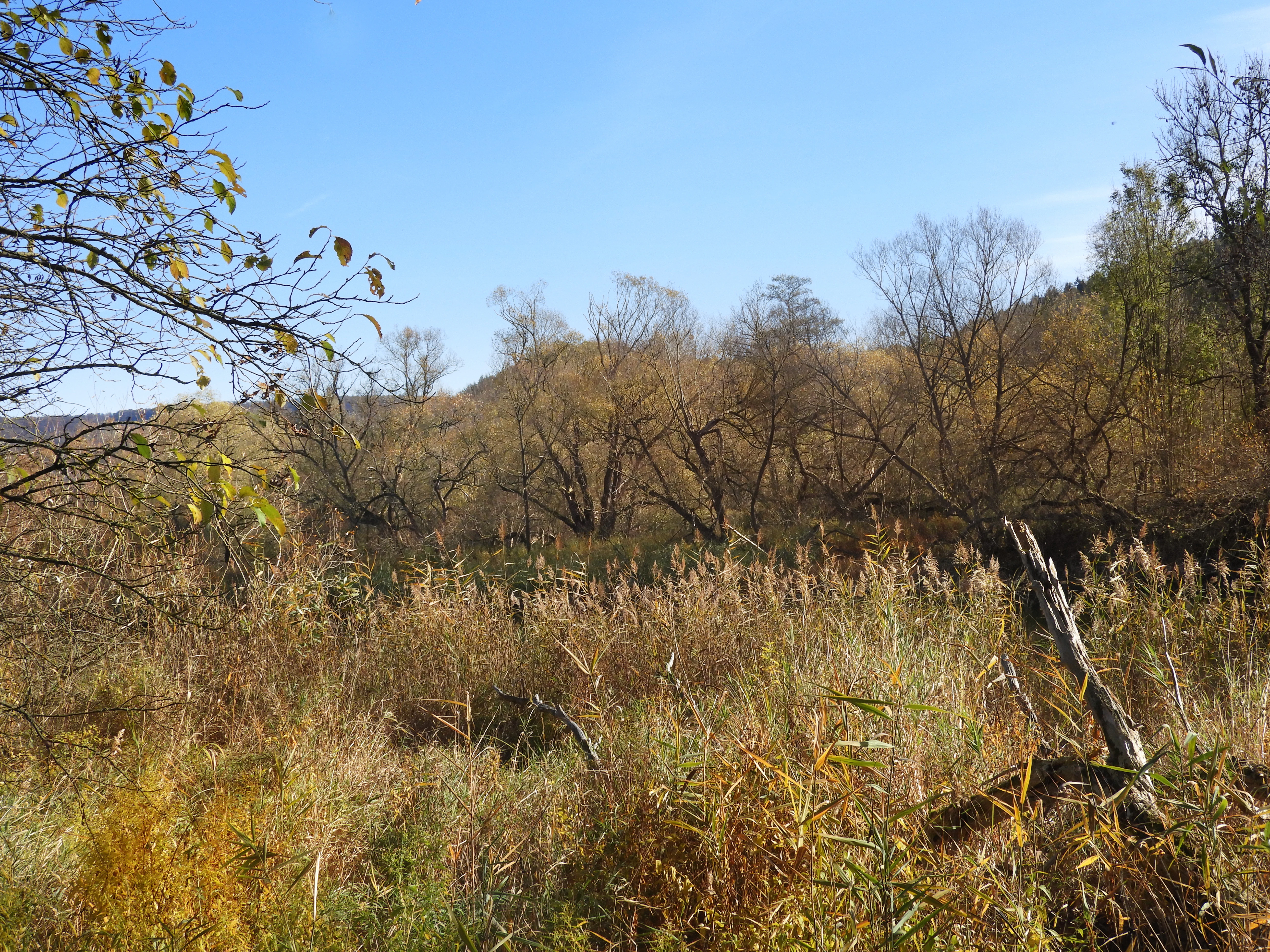
A view of a wetland area in autumn, featuring golden grasses and reeds in the foreground with deciduous trees and a hillside in the background under a blue sky.
Reeds and woodland habitat within the Kiesteich bei Frieda nature reserve.

Kiesteich bei Frieda history and protected-area timeline

The physical history of the Kiesteich bei Frieda began in the mid-1930s, when a gravel pit was excavated on the right bank of the Werra river, fundamentally altering the local topography. For several decades, the site was an active industrial zone before mining operations eventually ceased. Following the abandonment of the site, the excavated pit was left to fill, and nature began to reclaim the disturbed earth.

The formal protection of the area was established much later, driven by the growing ecological importance of the newly formed wetland. On July 22, 1988, the Regierungspräsidium in Kassel issued a formal ordinance to designate the pond and its surrounding fringes as a protected nature reserve, aiming to preserve its function as an amphibian spawning ground and a habitat for waterbirds. This ordinance was officially enacted when it was announced in the State Gazette of Hesse on May 22, 1989. Later, recognizing the broader ecological value of the contiguous river ecosystem, the pond was incorporated as a contrasting component into the Auenverbund Werra landscape protection area in 1992.

Kiesteich bei Frieda landscape and geographic character

The physical landscape of Kiesteich bei Frieda is defined by a shallow, roughly 6.6-hectare central pond that acts as the core geographical feature. This water surface is completely encircled by a dense, organic border of tall reeds, pioneer shrubs, and early-succession trees, forming a thick vegetative buffer that obscures the water from external view. The flat, marshy environment of the immediate reserve transitions abruptly into the surrounding agricultural lands, which are characterized by open fields on the eastern and western flanks.

On a broader regional scale, the reserve is embedded in the Eschweger Becken, a distinct natural region characterized by the wide, sweeping valley of the Werra. The high hills of the Osthessisches Bergland bracket the basin to the north, while the heavily forested ridges of the Fulda-Werra-Bergland, including the Schlierbachswald, overlook the terrain to the south. The Werra river itself runs immediately along the southern and southeastern edges of the reserve, providing a constant hydrological influence that shapes the microclimate and soil moisture of the protected grounds.

Kiesteich bei Frieda ecosystems, habitats, and plant life

The ecological character of the reserve is shaped almost entirely by the presence of standing water and the resulting hydrological conditions. The pond is bordered by a continuous belt of marshland vegetation, dominated by robust reedbeds that thrive in the saturated soils. Moving outward from the water, the habitat demonstrates a classic successional gradient. The former arable fields surrounding the pond were abandoned after the creation of the reserve, allowing them to transition from open, species-rich grass and tall herb meadows into relatively dense pre-forest growth, characterized by the spontaneous colonization of pioneer trees and hardy shrubs.

Because the area is officially off-limits to the public, the biological communities inside the reserve develop without human interference. This undisturbed status is highly significant for the local ecology, as it provides a stable environment for aquatic insects, emergent aquatic plants, and the complex microbial life of the wetland sediments. The integration of the site into the Geo-Naturpark Frau-Holle-Land further contextualizes the reserve as a vital component of the wider regional biodiversity, bridging the gap between the aquatic Werra ecosystem and the adjacent terrestrial forests.

Kiesteich bei Frieda wildlife and species highlights

The undisturbed nature of the reserve makes it an exceptionally valuable sanctuary for local wildlife, particularly for species dependent on aquatic environments. The pond and its protective reedbed fringes function as a crucial breeding, resting, and feeding ground for numerous waterbird species. Bird populations observed in and around the water include a mix of common, highly adaptable species alongside rarer birds that face significant conservation threats across Europe.

Amphibians represent the most documented and actively managed wildlife population within the reserve. The site hosts a particularly large congregation of common toads that migrate to the Kiesteich annually to spawn. To protect these vulnerable populations during their seasonal movements, conservation authorities worked with transportation planners to install permanent physical barriers along the adjacent Bundesstraße 249. These barriers guide the toads, along with various local frog and newt species, toward specially constructed underground tunnels that allow them to cross the highway safely as they make their way to and from their overwintering sites in the neighboring Eichenberg bei Frieda reserve.

Kiesteich bei Frieda conservation status and protection priorities

Conservation management at Kiesteich bei Frieda is structured around a tiered system of environmental protection. The core zone is maintained as a strict nature reserve, corresponding to the IUCN Category IV classification for habitat and species management areas. The primary legal framework was established by a 1988 ordinance, designed specifically to preserve the aquatic breeding grounds required by local amphibians and the nesting territories of waterbirds. By keeping the site completely free of public paths, conservation managers ensure that the wildlife experiences minimal levels of human disturbance.

At a wider scale, the reserve operates as a vital, protected component of the Auenverbund Werra landscape protection zone. Established in 1992 to cover approximately 4,000 hectares of the Werra floodplain, this broader designation aims to preserve the natural flooding cycles and the associated floodplain ecosystems of the river. Furthermore, the reserve is ecologically linked to nearby European conservation networks. To the north lies the Eichenberg bei Frieda FFH area, which protects dry oak forests and extensive meadows used by the amphibians. To the south, across the Werra valley, the Werra und Wehretal FFH area safeguards large continuous beech forests that provide critical hunting grounds for protected bat species, including the Greater Mouse-eared bat and Bechstein's bat.

Top sights and standout views in Kiesteich bei Frieda

A classic example of ecological reclamation, transitioning from a 1930s industrial gravel pit into a thriving, untouched biological sanctuary.

Functions as a critical, protected migration and spawning corridor for large populations of European amphibians, supported by specialized wildlife infrastructure along the Bundesstraße 249.

Offers a safe, undisturbed habitat for diverse waterbird populations, incorporating both common species and rare, threatened birds.

Serves as a foundational pillar of the regional conservation strategy, bridging strict local nature reserve protections with broad European FFH habitat networks across the Werra valley.

Monthly climate preview

Long-term representative temperature and precipitation data by month

Kiesteich bei Frieda Climate Normals and Annual Temperature Rhythm

Measured monthly normals at a representative coordinate outline the annual temperature span and precipitation rhythm across Kiesteich bei Frieda. Detailed records provide full month-by-month averages to evaluate long-term environmental patterns in depth.
Annual mean8 °C
-1 °C18 °C
Jan-1°
Feb
Mar
Apr
May12°
Jun16°
Jul18°
Aug18°
Sep14°
Oct
Nov
Dec
Warmest month
July

18.3 °C

Coolest month
January

-1.1 °C

Wettest month
July

2.6 mm/day

Driest month
April

1.4 mm/day

Park location guide

Geography guide, regional context, and park location map for Kiesteich bei Frieda

Kiesteich bei Frieda park geography, regions, and map view in Germany

Understand where Kiesteich bei Frieda sits in Germany through a broader geographic reading of the surrounding landscape, nearby location context, and its mapped position within the national park landscape.

How Kiesteich bei Frieda fits into Germany

Germany is a federal republic in Western and Central Europe with a population of over 83 million across sixteen constituent states. It is Europe's largest economy by nominal GDP and a major global exporter and importer. The capital is Berlin, and the country borders Denmark, Poland, Czech Republic, Austria, Switzerland, France, Luxembourg, Belgium, and the Netherlands.

Wider geography shaping Kiesteich bei Frieda in Germany

Germany is located in Western and Central Europe, spanning 357,022 km². It borders Denmark to the north, Poland and the Czech Republic to the east, Austria and Switzerland to the south, and France, Luxembourg, Belgium, and the Netherlands to the west. The country has coastlines on the Baltic Sea and North Sea to the north, with the Alps located in the southern region.

Map view of Kiesteich bei Frieda

Use this park location map to pinpoint Kiesteich bei Frieda in Germany, understand its exact geographic position, and read its mapped placement within the surrounding landscape more clearly.

Pigeon | © OpenStreetMap contributors

Location context for Kiesteich bei Frieda

Werra-Meißner-Kreis

Visual exploration of wetland habitats, reedbed fringes, and aquatic scenery

Kiesteich bei Frieda Photos and Protected Landscape Imagery

Visual records illustrate the wetland reclamation terrain, dense reedbed fringes, and aquatic habitats defining Kiesteich bei Frieda. Photographic documentation provides clear insight into the protected landscape character and regional river valley environment.

A view of a wetland area in autumn, featuring golden grasses and reeds in the foreground with deciduous trees and a hillside in the background under a blue sky.

Park atlas

Compare adjacent wetland reserves and regional valley habitats across northern Hesse

Explore Parks Near Kiesteich bei Frieda and Surrounding Protected Landscapes

Browsing other protected areas near Kiesteich bei Frieda reveals the broader ecological network of the Werra valley floodplain. Comparing these wetland habitats provides valuable geographic context for understanding regional conservation patterns.
A horizontal watercolor painting showing a calm pond with distant hills, trees on the left, and reeds on the right under a soft, sunset-colored sky.
Nature reserveWerra-Meißner-Kreis
About 0.9 km away#1 closest

East

Kiesteich unter der Aue’schen Kugel: Protected Nature Reserve and Wetland Landscape

Regional geography and habitat mapping in Werra-Meißner-Kreis

Kiesteich unter der Aue’schen Kugel is a specialized nature reserve that safeguards essential wetland habitats within the Werra river corridor. This protected area features two former gravel lakes shielded by dense vegetation, serving as a critical refuge for water-dependent species. Its inclusion in the Auenverbund Werra landscape protection network underscores its role in regional ecological connectivity and river-basin conservation efforts.

Area
0.093 km²
Established
1984
IUCN
IV
Access
Highly restricted
A watercolor painting showing a soft, stylized landscape with rolling hills in the background and a variety of bushes and wild vegetation in the foreground.
Nature reserveWerra-Meißner-Kreis
About 4 km away#2 closest

West

Mönchesrieth bei Grebendorf Nature Reserve in Werra-Meißner-Kreis, Germany

A restored wetland refuge in the Werra river floodplain.

Located in northern Hesse, Mönchesrieth bei Grebendorf is a protected nature reserve formed by the flooding of a former gravel extraction site. Its geography features a network of shallow bays and shoreline vegetation that provide essential nesting and foraging grounds for waterbirds within the busy Werra valley corridor. The site represents a successful transition from industrial terrain to a quiet, managed refuge for regional biodiversity.

Area
0.181 km²
Established
1999
IUCN
IV
Relief
Lowland
Wide watercolor illustration of green trees and hills with purple mountains in the background under a pale sky.
Nature reserveThuringia
About 5.5 km away#3 closest

Northwest

Stein, Rachelsberg, Gobert: A Protected Limestone Landscape in Western Thuringia

Mapping a historic nature reserve and beech forest complex

Stein, Rachelsberg, Gobert stands as a key protected area within Thuringia. This nature reserve offers deep insights into limestone ridge geography, historic border woodland continuity, and diverse habitats ranging from dry grasslands to tufa springs and orchid-rich beech forests.

Area
7.16 km²
Established
1999
IUCN
IV
Relief
Mountain
A horizontal watercolor painting depicting a soft-toned, layered landscape of rolling hills and forests in shades of green and pale yellow.
Nature reserveThuringia
About 7.6 km away#4 closest

Southeast

Adolfsburg, Bornberg, Sülzenberg: A Protected Muschelkalk Landscape in Thuringia

Geographic map and protected-area atlas context

This nature reserve stands as a prominent geological feature in the Werrabergland region, where steep Muschelkalk hills and plateaus meet the Werra valley. The site protects a rare assembly of habitats including juniper heathland, scree slopes, and old-growth orchards, offering a dense case study for regional botanical diversity and limestone-terrain mapping in central Germany.

Watercolor illustration showing a wide landscape with green rolling hills in the background, a line of trees in the midground, and a pinkish meadow with grasses in the foreground
Nature reserveHesse
About 7.9 km away#5 closest

Southeast

Frankenloch bei Heldra Nature Reserve: Mapped Protected Landscapes in Hesse, Germany

A rare, near-natural Werra river oxbow and wetland floodplain sanctuary.

Discover the geographic layout of Frankenloch bei Heldra, a protected nature reserve located along the River Werra. This site offers insight into floodplain dynamics, reed-bed ecology, and the restoration of natural river channels within the Werra-Meissner-Kreis district of Hesse, Germany.

Area
0.089 km²
Established
1995
Relief
Lowland
Climate
Temperate
A pale, panoramic watercolor painting depicting a series of rocky outcroppings surrounded by sparse green vegetation against a light, hazy background.
Nature reserveWerra-Meißner-Kreis
About 7.9 km away#6 closest

Southwest

Blaue Kuppe Nature Reserve: Volcanic Basalt Landscapes in Werra-Meißner-Kreis, Germany

Protected geological monument and habitat zone

Blaue Kuppe is a notable basalt hill near Eschwege, preserved for its rare mineralogical record and exposed contact zones between volcanic lava and sedimentary sandstone. The site serves as a vital geological archive and protected nature reserve in the Werra-Meißner-Kreis, showcasing historical volcanic intrusions that shaped the local terrain.

Area
0.068 km²
Established
1939
IUCN
IV
Relief
Upland
Nature reserveWartburgkreis
About 8.4 km away#7 closest

Southeast

Werraaue Treffurt Nature Reserve: Geographic Overview and Protected Floodplain Map

Wartburgkreis wetland refuge and Green Belt stepping stone

Werraaue Treffurt comprises a complex riverine landscape where sediment-rich floodplain soils and restored gravel-pit lakes create a diverse sanctuary. Located near the Thuringia-Hessia state border, this nature reserve integrates into the broader Green Belt, offering significant habitat continuity for species dependent on transition zones. Its position in the Werra valley floor highlights the intersection of hydrological change, historical land-use exclusion, and modern ecological protection in Germany.

Area
0.685 km²
Established
1995
IUCN
IV
Relief
Lowland
Nature reserveThuringia
About 8.4 km away#8 closest

Southeast

Werra bis Treffurt mit Zuflüssen: Protected River and Floodplain Network in Thuringia

Mapping an extensive 191 kilometer Natura 2000 river corridor.

The Werra bis Treffurt mit Zuflüssen protected area serves as a vital ecological corridor in Thuringia. This site encompasses a complex mosaic of fast-flowing highland brooks, expansive floodplain meadows, inland salt sites, and rare dissolution lakes. Its geography bridges high-altitude source regions with lower river valleys, creating a distinctive landscape transect that supports essential freshwater habitats and rare aquatic species across the state.

Area
22.6 km²
Established
2008
IUCN
IV
Relief
Mixed relief

Common questions about visiting, size, designation, and location context for Kiesteich bei Frieda

Kiesteich bei Frieda FAQs for park facts, access, geography, and protected area context

Find quick answers about Kiesteich bei Frieda, including protected-area facts, park geography, trail and visitor context, and how the park fits into its surrounding country and regional landscape.
MoriAtlas Explorer

Continue Your Protected Areas Search Across the Global Atlas

Deepen your exploration by continuing the structured search for national parks and protected areas worldwide. Utilize the comprehensive filtering capabilities to compare different conservation landscapes and refine your understanding of global park geography. Discover more about the distribution and characteristics of protected natural areas.

Global natural geography