
Mori Atlas logo
Nature reserveKiesteich unter der Aue’schen Kugel

Understanding the mapped boundaries and geographic context of this significant river-valley nature reserve

Kiesteich unter der Aue’schen Kugel: A Protected Wetland Refuge in Werra-Meißner-Kreis

(Naturschutzgebiet Kiesteich unter der Aue'schen Kugel)

Kiesteich unter der Aue’schen Kugel represents a carefully managed nature reserve in northern Hesse; serving as a vital sanctuary for waterbirds within the larger Auenverbund Werra conservation corridor. Located at the transition between the Werra river floodplain and the forested slopes of the Schlierbachswald, this protected area transforms former gravel extraction sites into a stable, disturbance-free wetland environment. Its geographic position within the Eschweger Becken highlights the interplay between reclaimed industrial land and regional floodplain ecology.

nature reservegravel pit lakeswetland habitatwaterbird refugeriver floodplainnorthern Hesse
A digital illustration of a calm pond with a small sandbar, several small birds, and dense green forest in the background under a soft sunset sky.

Kiesteich unter der Aue’schen Kugel

Nature reserve

Park overview

Structured park overview, official facts, and landscape profile for Kiesteich unter der Aue'schen Kugel

Kiesteich unter der Aue'schen Kugel park facts, protected area profile, and essential visitor context

Review the core facts for Kiesteich unter der Aue'schen Kugel, including designation, size, terrain, visitor scale, habitats, and operating context in one park-focused overview.

About Kiesteich unter der Aue'schen Kugel

Kiesteich unter der Aue'schen Kugel is a small but ecologically focused nature reserve in the Werra-Meißner-Kreis of northern Hesse, managed specifically to support water-dependent birdlife in a river-valley setting that has otherwise been altered by centuries of agriculture and modern gravel extraction. The protected area lies in the territory of the town of Wanfried and sits on the left bank of the Werra, within the broader geographic unit known as the Eschweger Becken, an open basin where the Werra has historically meandered across alluvial terrain.

The reserve's two lakes originated as gravel excavation pits. After extraction was completed, the resulting water bodies were deliberately incorporated into a protected framework rather than being filled in or developed. In December 1984, an ordinance from the regional forestry and nature conservation authority in Kassel formally established the 9.31-hectare area as a nature reserve. The official purpose was to secure and maintain a disturbance-free breeding and resting habitat for waterbirds, particularly species of conservation concern, while still permitting limited extensive use of the surrounding grassland beyond the standard model ordinance.

A defining physical feature of the site is a dense, continuous strip of shrubs and trees that surrounds the lakes, creating a visual and acoustic buffer from nearby farmland, roads, and angling ponds. The Werra bounds the area to the north, separated from the lakes by roughly a twenty-meter-wide embankment. To the east lies open farmland, to the west additional former gravel pits now used by anglers, and to the south the protection zone ends where the cycle path between Wanfried and the village of Aue runs alongside the Landesstraße 3244, below the wooded Aue'sche Kugel hill. Public access to the lakes themselves is intentionally restricted to preserve their function as a refuge habitat.

Quick facts and research context for Kiesteich unter der Aue'schen Kugel

Nature reserve status: designated in December 1984 by the Bezirksdirektion für Forsten und Naturschutz at the Kassel regional administration. Area: about 9.31 hectares in total. Composition: two post-extraction gravel pit lakes of roughly one and four hectares, enclosed by a continuous dense shrub and woodland margin. Location: in the Wanfried municipal area, Werra-Meißner-Kreis, northern Hesse, immediately west of the Werra river. Geomorphological setting: lower Werra hill country, at the boundary between the Schwebda-Jestädter Werraaue and the Treffurt-Wanfrieder Werratal. IUCN management category: IV (Habitat/Species Management Area). National identifier: 1636011; WDPA code: 164091. Overlapping designation: fully within the landscape protection area Auenverbund Werra, established in 1992.

Protection and recognition

Examine the verified conservation metadata and official registry records for this protected site.

Kiesteich unter der Aue’schen Kugel Protection Status and Designated Area Record

Kiesteich unter der Aue’schen Kugel holds recorded entries within global protected area databases, establishing baseline administrative data. Reviewers can access verified designation details and governance information mapped to standard registry identifiers.

Protection details

WDPA ID
164091
Park context

Deeper park guide and search-rich context for Kiesteich unter der Aue'schen Kugel

Kiesteich unter der Aue'schen Kugel history, landscape, wildlife, and travel context

Explore Kiesteich unter der Aue'schen Kugel through its history, landscape character, ecosystems, wildlife, conservation priorities, cultural context, and seasonal travel timing in a structured park guide built for atlas discovery and search intent.

Why Kiesteich unter der Aue'schen Kugel stands out

The reserve is best known as a quiet, disturbance-free refuge for waterbirds along the Werra, created intentionally from exhausted gravel pits. Its ecological value comes from the combination of open water, a surrounding woody buffer, and proximity to a larger river floodplain that together offer nesting and stopover conditions for water-dependent bird species. Because the lakes are not visible from the public cycle path that passes along the edge, the site is essentially a hidden conservation feature within the agricultural and river-influenced Werra valley landscape.
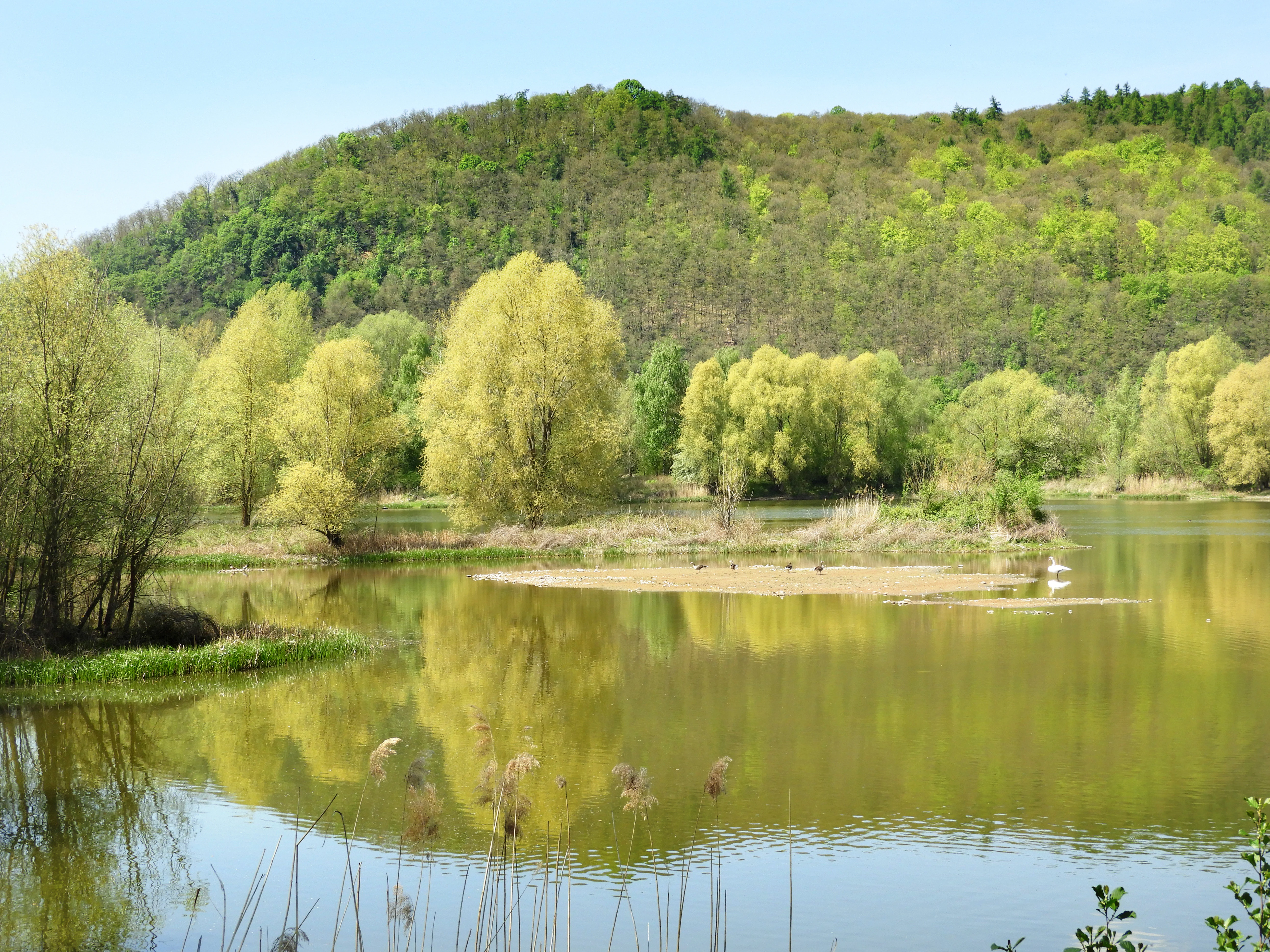
A calm, still pond with reflections of trees in the water, a small gravel island in the center, and a large, wooded hill rising in the background under a clear sky.
A scenic view of the Kiesteich unter der Aue’schen Kugel nature reserve, featuring a peaceful pond and surrounding riparian forest.

Kiesteich unter der Aue'schen Kugel history and protected-area timeline

The history of the Kiesteich begins not with conservation but with industrial gravel extraction. The two lakes that now form the core of the reserve are former Kiestagebau pits, worked for the gravel deposits of the Werra floodplain. Once extraction ceased, the question of what to do with the resulting water bodies became a recognized conservation opportunity rather than a liability, in line with the broader practice in Germany of repurposing exhausted pits as aquatic habitats.

Formal protection came on 13 December 1984, when the Bezirksdirektion für Forsten und Naturschutz at the Regierungspräsidium Kassel issued an ordinance declaring roughly 9.31 hectares around the lakes as a nature reserve. The objective defined in that ordinance was explicit: to secure an undisturbed breeding and roosting area for waterbirds and especially for threatened species among them. Some limited extensive grassland use was still allowed, in a deliberately restrained departure from the standard model ordinance used elsewhere in Hesse.

In 1992, the reserve was incorporated into the much larger Auenverbund Werra landscape protection area, a nearly 4,000-hectare corridor stretching along the middle and lower Werra through the Hersfeld-Rotenburg and Werra-Meißner districts. This broader designation aims to protect meadow and riparian vegetation, preserve near-natural stretches of the river, and where possible restore them. Since then, the Kiesteich has functioned less as an isolated reserve and more as a key node in this connected Werra floodplain conservation network, although the earliest recognition of its value dates back to the 1984 ordinance.

Kiesteich unter der Aue'schen Kugel landscape and geographic character

The protected area sits in a relatively quiet corner of the lower Werra hill country, at the boundary where the flat alluvial Werra floodplain meets the rising slopes of the surrounding wooded ridges. The reserve itself is essentially a mosaic of two still-water bodies and their wooded margin, set into an otherwise open agricultural basin.

According to the standard German natural area classification prepared by the Bundesforschungsanstalt für Landeskunde und Raumordnung in Bad Godesberg, the Kiesteich lies in the Unteres Werrabergland, more precisely at the interface between the Schwebda-Jestädter Werraaue in the Eschweger Becken and the narrower Treffurt-Wanfrieder Werratal to the east. Looking south, the terrain climbs into the Schlierbachswald, part of the Fulda-Werra-Bergland, which in turn belongs to the larger Osthessisches Bergland. These nested units describe a transitional landscape where lowland river dynamics give way to forested uplands within only a short distance.

The local terrain is shaped by the Werra itself, which flows past the reserve to the north and is held back from the lakes by a roughly twenty-meter embankment. To the south, the 274-meter Aue'sche Kugel rises at the northeastern end of the Schlierbachswald. Between the road, the cycle path, and the forested hill, the reserve occupies a narrow but visually compressed stretch of land that emphasizes its character as a tucked-away wetland pocket rather than a broad open landscape.

Kiesteich unter der Aue'schen Kugel ecosystems, habitats, and plant life

Ecologically, the Kiesteich functions primarily as an aquatic and wetland habitat set within an otherwise agricultural and historically disturbed Werra floodplain context. The two lakes are the heart of the system, providing open-water conditions that are otherwise scarce in this intensively used section of the Werra valley. Together with the surrounding land, they offer a combination of aquatic, reed-like, and shrubby microhabitats within a very compact area.

A crucial ecological feature is the dense, continuous strip of woody vegetation that closely encircles both lakes. This buffer shields the water surfaces visually and acoustically, reducing disturbance from passing traffic, anglers on neighboring ponds, and agricultural activity on adjacent fields. The wooded margin also adds structural diversity, creating transition zones between open water, thicket, and the open grassland beyond, which is valuable for a range of species that move between these habitats.

The reserve sits within the larger Auenverbund Werra landscape protection area, a floodplain-oriented corridor covering meadow and riparian vegetation types along the Werra. Its main goal is to protect near-natural stretches of the river and, where possible, to restore them. By being fully nested within this larger landscape framework, the Kiesteich contributes a stable aquatic refuge to a broader network that connects scattered wetland and meadow fragments across multiple districts and significantly expands the effective habitat range of water-dependent species.

Kiesteich unter der Aue'schen Kugel wildlife and species highlights

The reserve is managed and officially designed as a habitat for waterbirds, Wasservögel, with particular attention to species whose populations are of conservation concern in Germany. The official protection ordinance identifies the safeguarding of a disturbance-free breeding and roosting area for these birds as the primary purpose of the designation, meaning that wildlife value is not incidental but centrally embedded in the reserve's legal and management purpose.

The combination of relatively undisturbed open water, dense woody buffer, and proximity to a larger river system makes the Kiesteich attractive both for resident breeding waterbirds during the warmer months and for migratory or wintering species that require quiet stretches of water along the Werra corridor. Because the lakes are deliberately screened from public view and access, they offer a low-disturbance refuge that complements, rather than competes with, the angling ponds located immediately to the west.

Beyond waterbirds, the wooded margin and the immediately adjacent Werra river support typical riparian fauna associated with central German low mountain river landscapes. The reserve is best understood, however, not as a broadly diverse multi-habitat site, but as a focused, well-buffered wetland refuge whose wildlife significance lies mainly in providing reliable, quiet habitat conditions for water-dependent birds along an otherwise heavily altered section of the Werra valley.

Kiesteich unter der Aue'schen Kugel conservation status and protection priorities

From a conservation perspective, the Kiesteich unter der Aue'schen Kugel is a textbook example of how a former extraction site can be transformed into a purpose-built protected area. After gravel mining ceased, rather than being lost to development or backfilled, the resulting water bodies were secured under a 1984 nature reserve ordinance specifically because of their potential value for waterbird habitat in an already heavily modified river-valley landscape.

The site's conservation significance rests on three layered designations. First, the IUCN-classified nature reserve core provides narrowly tailored protection with disturbance control as its central objective. Second, the reserve sits fully within the Auenverbund Werra landscape protection area, established in 1992, which extends broad floodplain-oriented protection across nearly 4,000 hectares of the middle and lower Werra. Together, these layers mean the Kiesteich is not an isolated reserve but an integral ecological node within a much larger riverine conservation network.

The reserve's conservation value is therefore not primarily about landscape grandeur but about functional habitat contribution: providing quiet, well-buffered aquatic habitat that compensates, at least locally, for the loss of natural river dynamics along this stretch of the Werra. The deliberate visual screening of the lakes from nearby roads and paths, and the absence of public access to the water bodies themselves, reflect a management approach that prioritizes habitat quality for sensitive species over recreational or educational use.

Kiesteich unter der Aue'schen Kugel cultural meaning and human context

The Kiesteich does not have a strongly developed cultural or human narrative of its own, and the surrounding cultural context is largely defined by the Werra valley landscape and the small town of Wanfried. The reserve lies at the foot of the Aue'sche Kugel hill, a local toponym that anchors the site in the rural settlement geography of this part of northern Hesse. The reserve area falls within the Geo-Naturpark Frau-Holle-Land, a regional geopark that links natural heritage with the cultural landscape of the Werra and Fulda river systems and the associated folklore of the Frau Holle figure.

The interweaving of modern industrial land use, in this case gravel extraction, with nature conservation is itself a notable element of the area's contemporary identity. Gravel pits are common features of the Werra floodplain in this region, and their reuse as protected habitats is part of a broader pattern of how the working river landscape has been re-imagined for ecological ends after extraction ends.

Top sights and standout views in Kiesteich unter der Aue'schen Kugel

The reserve's standout quality is the way it transforms a former industrial scar into a quiet, protected wetland refuge. Its two lakes, originally left behind by gravel extraction, are now the core of a stable habitat for waterbirds, ringed by a dense wooded buffer that shields them from the surrounding farmland and roads. The site's full inclusion in the large Auenverbund Werra landscape protection area gives it significance well beyond its modest size, linking it into a regional floodplain conservation corridor.

Equally notable is the deliberate management philosophy that defines the Kiesteich. The lakes themselves are not designed for visitor use and are not even visible from the public cycle path that skirts the reserve along the Werratal-Radweg. This choice reflects a clear prioritization of habitat function over recreational access, making the reserve a useful case study in focused, low-disturbance conservation design within an intensively used river-valley landscape.

Best time to visit Kiesteich unter der Aue'schen Kugel

Although the reserve itself is not a visitor attraction and visitors are explicitly asked not to enter the protected zone around the lakes, the surrounding Werra valley landscape can be appreciated at any time of year via the Werratal-Radweg cycle route and the Herkules-Wartburg-Radweg variant that pass just south of the area. Spring and early summer are typically the most rewarding seasons along the Werra valley, when waterbird activity is highest, surrounding meadows and hedgerows are in growth, and the wooded Aue'sche Kugel and Schlierbachswald slopes are in full leaf. Late autumn and winter can also be of interest for those interested in migratory and overwintering waterfowl, as these are periods when such species concentrate around quiet water bodies along the river. Visitors should bear in mind that the lakes themselves are intentionally not accessible and that the experience is primarily one of cycling or walking through the surrounding landscape, not of entering the reserve.

Monthly climate preview

Long-term annual temperature and precipitation patterns from representative coordinates

Kiesteich unter der Aue’schen Kugel Climate Normals and Temperature Rhythms

Historical measurements from 1991 to 2000 outline the measured temperature ranges and monthly precipitation averages recorded at a representative coordinate within Kiesteich unter der Aue’schen Kugel. Detailed twelve-month climate normals provide deeper insight into long-term environmental trends across the protected area.
Annual mean8 °C
-1 °C18 °C
Jan-1°
Feb
Mar
Apr
May12°
Jun16°
Jul18°
Aug18°
Sep14°
Oct
Nov
Dec
Warmest month
July

18.3 °C

Coolest month
January

-1.1 °C

Wettest month
July

2.6 mm/day

Driest month
April

1.4 mm/day

Park location guide

Geography guide, regional context, and park location map for Kiesteich unter der Aue'schen Kugel

Kiesteich unter der Aue'schen Kugel park geography, regions, and map view in Germany

Understand where Kiesteich unter der Aue'schen Kugel sits in Germany through a broader geographic reading of the surrounding landscape, nearby location context, and its mapped position within the national park landscape.

How Kiesteich unter der Aue'schen Kugel fits into Germany

Germany is a federal republic in Western and Central Europe with a population of over 83 million across sixteen constituent states. It is Europe's largest economy by nominal GDP and a major global exporter and importer. The capital is Berlin, and the country borders Denmark, Poland, Czech Republic, Austria, Switzerland, France, Luxembourg, Belgium, and the Netherlands.

Wider geography shaping Kiesteich unter der Aue'schen Kugel in Germany

Germany is located in Western and Central Europe, spanning 357,022 km². It borders Denmark to the north, Poland and the Czech Republic to the east, Austria and Switzerland to the south, and France, Luxembourg, Belgium, and the Netherlands to the west. The country has coastlines on the Baltic Sea and North Sea to the north, with the Alps located in the southern region.

Map view of Kiesteich unter der Aue'schen Kugel

Use this park location map to pinpoint Kiesteich unter der Aue'schen Kugel in Germany, understand its exact geographic position, and read its mapped placement within the surrounding landscape more clearly.

Pigeon | © OpenStreetMap contributors

Location context for Kiesteich unter der Aue'schen Kugel

Werra-Meißner-Kreis

Visualizing the habitats, waterbird refuge, and protected valley terrain

Kiesteich unter der Aue’schen Kugel Photos and Landscape Scenery

Visual records reveal the sheltered waters, wooded wetland margins, and transitional river-valley geography that define the protected landscape. Examining actual park photography helps observers understand the quiet ecological character and habitat structure within the lower Werra basin.

A calm, still pond with reflections of trees in the water, a small gravel island in the center, and a large, wooded hill rising in the background under a clear sky.

Park atlas

Compare adjacent wetland reserves and regional river valley conservation areas across northern Hesse.

Exploring Parks Near Kiesteich unter der Aue’schen Kugel and Surrounding Protected Landscapes

Browsing other protected areas near Kiesteich unter der Aue’schen Kugel reveals a broader network of river valley wetlands and forested hill reserves. Evaluating these adjacent conservation sites provides essential geographical context for northern Hesse wetland habitats.
A horizontal watercolor painting depicting a calm lake with marshy grass in the foreground and rolling mountains in the distance under a soft, pale sky.
Nature reserveWerra-Meißner-Kreis
About 0.9 km away#1 closest

West

Kiesteich bei Frieda Nature Reserve: Exploring the Protected Geography of Werra-Meißner-Kreis

A detailed look at wetland habitats and landscape reclamation in the Werra valley

Kiesteich bei Frieda is a protected nature reserve nestled in the Werra valley of the Werra-Meißner-Kreis. This area, originally formed through gravel mining, now provides a dense vegetative buffer and aquatic ecosystem that serves as a vital corridor for amphibians and waterbirds. Discover the geographic features that define this essential protected sanctuary and understand its integration into the wider regional environmental network.

Area
0.066 km²
Established
1988
IUCN
IV
Relief
Lowland
A watercolor painting showing a soft, stylized landscape with rolling hills in the background and a variety of bushes and wild vegetation in the foreground.
Nature reserveWerra-Meißner-Kreis
About 4.8 km away#2 closest

West

Mönchesrieth bei Grebendorf Nature Reserve in Werra-Meißner-Kreis, Germany

A restored wetland refuge in the Werra river floodplain.

Located in northern Hesse, Mönchesrieth bei Grebendorf is a protected nature reserve formed by the flooding of a former gravel extraction site. Its geography features a network of shallow bays and shoreline vegetation that provide essential nesting and foraging grounds for waterbirds within the busy Werra valley corridor. The site represents a successful transition from industrial terrain to a quiet, managed refuge for regional biodiversity.

Area
0.181 km²
Established
1999
IUCN
IV
Relief
Lowland
Wide watercolor illustration of green trees and hills with purple mountains in the background under a pale sky.
Nature reserveThuringia
About 6 km away#3 closest

Northwest

Stein, Rachelsberg, Gobert: A Protected Limestone Landscape in Western Thuringia

Mapping a historic nature reserve and beech forest complex

Stein, Rachelsberg, Gobert stands as a key protected area within Thuringia. This nature reserve offers deep insights into limestone ridge geography, historic border woodland continuity, and diverse habitats ranging from dry grasslands to tufa springs and orchid-rich beech forests.

Area
7.16 km²
Established
1999
IUCN
IV
Relief
Mountain
A horizontal watercolor painting depicting a soft-toned, layered landscape of rolling hills and forests in shades of green and pale yellow.
Nature reserveThuringia
About 7.3 km away#4 closest

Southeast

Adolfsburg, Bornberg, Sülzenberg: A Protected Muschelkalk Landscape in Thuringia

Geographic map and protected-area atlas context

This nature reserve stands as a prominent geological feature in the Werrabergland region, where steep Muschelkalk hills and plateaus meet the Werra valley. The site protects a rare assembly of habitats including juniper heathland, scree slopes, and old-growth orchards, offering a dense case study for regional botanical diversity and limestone-terrain mapping in central Germany.

Watercolor illustration showing a wide landscape with green rolling hills in the background, a line of trees in the midground, and a pinkish meadow with grasses in the foreground
Nature reserveHesse
About 7.6 km away#5 closest

Southeast

Frankenloch bei Heldra Nature Reserve: Mapped Protected Landscapes in Hesse, Germany

A rare, near-natural Werra river oxbow and wetland floodplain sanctuary.

Discover the geographic layout of Frankenloch bei Heldra, a protected nature reserve located along the River Werra. This site offers insight into floodplain dynamics, reed-bed ecology, and the restoration of natural river channels within the Werra-Meissner-Kreis district of Hesse, Germany.

Area
0.089 km²
Established
1995
Relief
Lowland
Climate
Temperate
A wide watercolor painting showing a gentle river winding through green hills with pink flowering trees and pale blue mountains in the background.
Nature reserveUnstrut-Hainich-Kreis
About 7.9 km away#6 closest

East

Klosterschranne, Faulunger Stein Nature Reserve: Mapped Boundaries and Regional Geography

A protected Muschelkalk valley landscape in the Thuringia region

Klosterschranne, Faulunger Stein consists of a protected woodland and rock environment shaped by limestone erosion. The reserve features sharp valley spurs, calcareous springs, and cliffs that rise up to thirty meters, anchoring a larger network of habitats within the Upper Eichsfeld plateau. Users can examine the layered conservation status and distinct topographic features that define this ecologically significant German site.

Area
2.983 km²
Established
1996
IUCN
IV
Relief
Mountain
Nature reserveWartburgkreis
About 8.1 km away#7 closest

Southeast

Werraaue Treffurt Nature Reserve: Geographic Overview and Protected Floodplain Map

Wartburgkreis wetland refuge and Green Belt stepping stone

Werraaue Treffurt comprises a complex riverine landscape where sediment-rich floodplain soils and restored gravel-pit lakes create a diverse sanctuary. Located near the Thuringia-Hessia state border, this nature reserve integrates into the broader Green Belt, offering significant habitat continuity for species dependent on transition zones. Its position in the Werra valley floor highlights the intersection of hydrological change, historical land-use exclusion, and modern ecological protection in Germany.

Area
0.685 km²
Established
1995
IUCN
IV
Relief
Lowland
Nature reserveThuringia
About 8.1 km away#8 closest

Southeast

Werra bis Treffurt mit Zuflüssen: Protected River and Floodplain Network in Thuringia

Mapping an extensive 191 kilometer Natura 2000 river corridor.

The Werra bis Treffurt mit Zuflüssen protected area serves as a vital ecological corridor in Thuringia. This site encompasses a complex mosaic of fast-flowing highland brooks, expansive floodplain meadows, inland salt sites, and rare dissolution lakes. Its geography bridges high-altitude source regions with lower river valleys, creating a distinctive landscape transect that supports essential freshwater habitats and rare aquatic species across the state.

Area
22.6 km²
Established
2008
IUCN
IV
Relief
Mixed relief

Common questions about visiting, size, designation, and location context for Kiesteich unter der Aue'schen Kugel

Kiesteich unter der Aue'schen Kugel FAQs for park facts, access, geography, and protected area context

Find quick answers about Kiesteich unter der Aue'schen Kugel, including protected-area facts, park geography, trail and visitor context, and how the park fits into its surrounding country and regional landscape.
MoriAtlas Explorer

Continue Your Protected Areas Search Across the Global Atlas

Deepen your exploration by continuing the structured search for national parks and protected areas worldwide. Utilize the comprehensive filtering capabilities to compare different conservation landscapes and refine your understanding of global park geography. Discover more about the distribution and characteristics of protected natural areas.

Global natural geography