Mori Atlas logo
State or regional parkKilby Provincial Park

A study in protected riparian geography and pioneer history in British Columbia

Kilby Provincial Park: Exploring the Harrison River Flood Plain and Heritage Landscapes

Kilby Provincial Park preserves a distinctive stretch of the Harrison River flood plain in British Columbia, serving as an intersection for both heritage preservation and natural riverfront ecosystems. The protected area features an elevated boardwalk network that traverses low-lying terrain, providing access to seasonal birding sites and open riverside spaces. This geography supports a unique blend of historical farm structures and aquatic wildlife habitats that define the park character within the Upper Fraser Valley.

provincial parkBritish ColumbiaFraser ValleyHarrison Riverriverfront parkcampground

Kilby Provincial Park

State or regional park

Park overview

Structured park overview, official facts, and landscape profile for Kilby Provincial Park

Kilby Provincial Park park facts, protected area profile, and essential visitor context

Review the core facts for Kilby Provincial Park, including designation, size, terrain, visitor scale, habitats, and operating context in one park-focused overview.

About Kilby Provincial Park

Kilby Provincial Park sits on the banks of the Harrison River in the community of Harrison Mills, in the Upper Fraser Valley of southwestern British Columbia. Although it is one of the smaller parks in the BC Parks system, its combination of natural shoreline, basic camping infrastructure, and an on-site heritage attraction gives it a layered character unusual for a park of its size. The river setting, the surrounding flood plain, and the historic buildings together define what visitors experience at Kilby.

The park encompasses approximately three hectares of land and includes thirty campsites and a boat launch, making it a practical base for exploring the Harrison River and the broader Fraser Valley landscape. A sandy summer beach along the river is one of the park's main warm-weather attractions, offering an accessible stretch of shoreline for day users and campers. Because the property lies on a flood plain, the historic structures within the park were deliberately elevated and connected by boardwalks, a decision that continues to shape the visual character of the site.

At a broader level, Kilby's significance is twofold. Ecologically, its position on the Harrison River places it within a corridor used by migratory birds, including trumpeter swans from Alaska and large numbers of bald eagles, giving the park a seasonal importance that extends beyond its modest size. Culturally, the Kilby Historic Site preserves a tangible record of early pioneer commerce and community life in the Fraser Valley through the original General Store, the Manchester House Hotel and Post Office, and the surrounding heritage farm. Together these qualities make Kilby Provincial Park a compact but distinctive entry in British Columbia's network of provincial parks.

Quick facts and research context for Kilby Provincial Park

Kilby Provincial Park is located in Harrison Mills within the Fraser Valley Regional District of British Columbia, on the Harrison River overlooking Harrison Bay. Established on 28 August 1973 and managed by BC Parks, it is a small IUCN Category II protected area covering roughly three hectares.

The park combines a 30-site campground and a boat launch on the river with the Kilby Historic Site, a heritage farm that preserves early twentieth-century Fraser Valley life around the original Kilby General Store. Its setting on a flood plain has shaped both its built heritage and its current role as a seasonal wildlife viewing area along the Harrison River corridor.

Protection and recognition

Documented terrestrial protection scope and recognition history for Kilby Provincial Park

Kilby Provincial Park Protection Status and Designated Area Record

Kilby Provincial Park maintains a documented terrestrial protection scope without international recognition sources or transboundary designations on record. Systematic protected area tracking details the administrative designation framework and conservation status associated with this landscape.

Protection details

Protection scope
Terrestrial
Transboundary protection
No
Park context

Deeper park guide and search-rich context for Kilby Provincial Park

Kilby Provincial Park history, landscape, wildlife, and travel context

Explore Kilby Provincial Park through its history, landscape character, ecosystems, wildlife, conservation priorities, cultural context, and seasonal travel timing in a structured park guide built for atlas discovery and search intent.

Why Kilby Provincial Park stands out

Kilby Provincial Park is especially known for the pairing of a compact riverside campground with the Kilby Historic Site, a living history farm built around the early twentieth-century Kilby General Store. The park's riverside beach and campground make it a popular warm-weather stop in the Upper Fraser Valley, while its position along the Harrison River gives it a strong seasonal wildlife identity. In fall and winter the park becomes a viewing point for bald eagles and trumpeter swans migrating from Alaska, drawing birdwatchers to a park that, in summer, functions primarily as a family-friendly heritage and beach destination. This blend of small-scale outdoor recreation, Fraser Valley pioneer history, and accessible birding is what sets Kilby apart from many other small BC provincial parks.
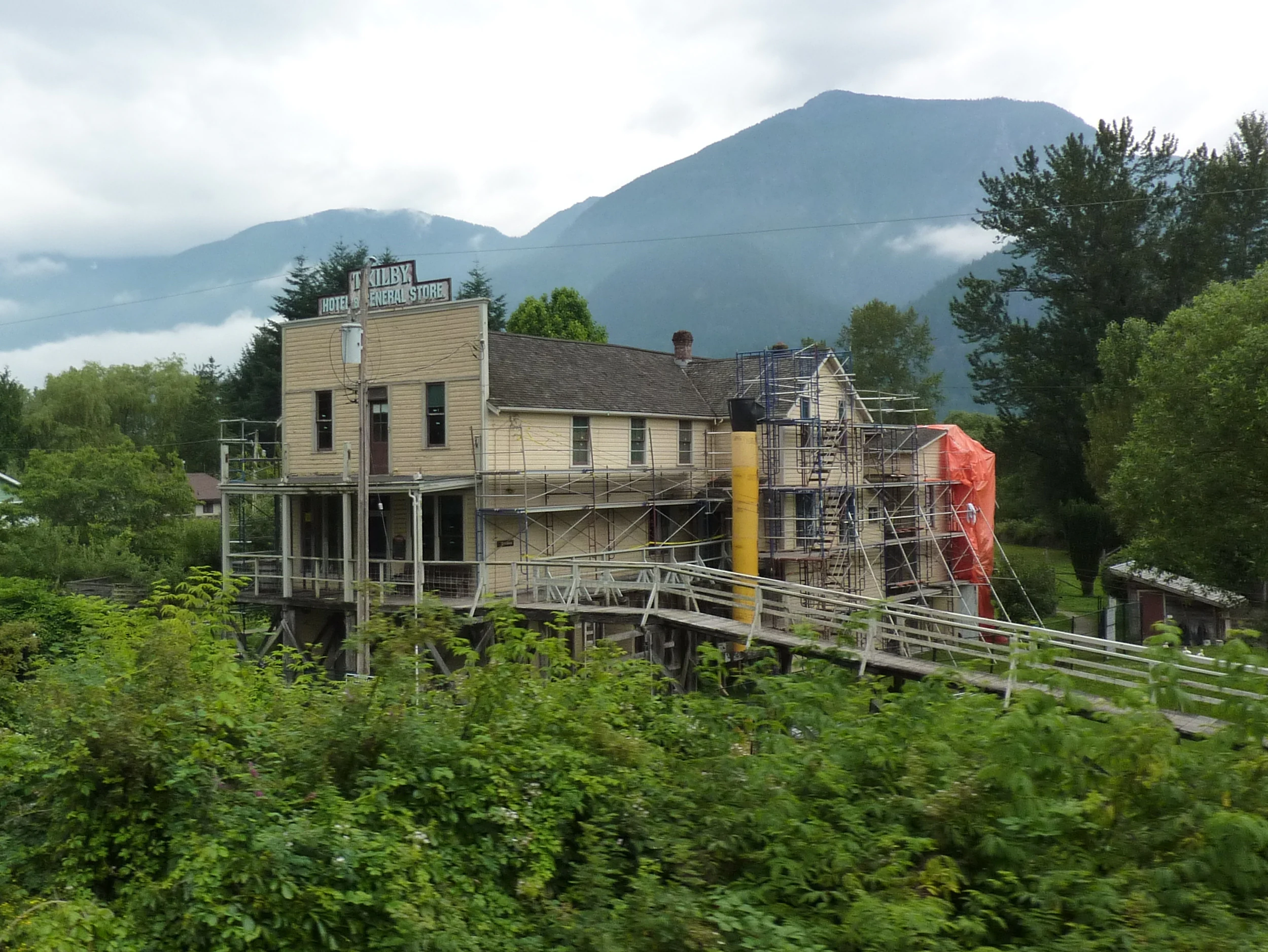
A historic, two-story wooden building with scaffolding surrounding it, set against a backdrop of hazy, cloud-covered mountains.
The historic Kilby Hotel and General Store at Kilby Provincial Park.

Kilby Provincial Park history and protected-area timeline

Kilby Provincial Park was formally established on 28 August 1973 and is managed by BC Parks as an IUCN Category II protected area. The park's identity, however, is closely tied to an older story: the pioneering Kilby family and their role in the early commercial life of Harrison Mills.

Thomas and Eliza Kilby converted an existing temperance hotel, built on pilings and linked to the railway station by a ramp to its second storey, into a general store in 1906. The store quickly became a focal point of the small Harrison Mills community. Their son, Acton Kilby, took over the operation in 1922 and inherited the store outright after Thomas's death in 1928. Acton and his wife Jessie continued to run the General Store until 1977, turning it into one of the longest-operating family businesses in the area.

The early twentieth century brought new forms of travel to the Fraser Valley. In 1926, automobiles began to appear at Harrison Mills, and the Kilbys installed gravity-fed gas pumps that served travellers for several decades. In 1973, the same year the surrounding park was established, Acton received a plaque from Imperial Oil recognizing fifty years of service. The heritage farm that now forms the Kilby Historic Site preserves the General Store, the Manchester House Hotel and Post Office, boardwalks linking the elevated buildings, and a collection of artefacts that together reflect the daily rhythms of early Fraser Valley life.

Kilby Provincial Park landscape and geographic character

Kilby Provincial Park occupies a small but visually distinctive stretch of the Harrison River flood plain in the Upper Fraser Valley. The defining landscape element is the river itself, which curves past the park and opens out toward Harrison Bay, providing both the scenery and the seasonal wildlife setting that characterize the site.

The park's land sits low on the flood plain, a fact that historically required buildings to be raised on pilings and connected by boardwalks. Visitors still encounter this elevated, boardwalk-linked built environment, which sits alongside open grassy areas, an orchard playground, and a sandy riverside beach used in summer. The riverbank, the gentle flood-plain topography, and the surrounding Fraser Valley forest and farmland together create a landscape where water, wetland edge, and human settlement meet within a very small footprint.

Kilby Provincial Park ecosystems, habitats, and plant life

Although Kilby is far smaller than many of British Columbia's protected areas, its position along the Harrison River gives it a meaningful ecological role. The river corridor it adjoins supports seasonal concentrations of birds, and the park's shoreline and adjacent waters form part of a wider habitat network used by both resident and migratory species.

The mix of river, flood plain, and surrounding vegetation supports a transitional environment where water, grassland, and woodland habitats meet. This ecological variety, even within a compact footprint, is what allows the park to function as both a summer recreation area and a winter wildlife viewing site, with the same stretch of shoreline delivering very different ecological experiences across the seasons.

Kilby Provincial Park wildlife and species highlights

Wildlife viewing is one of Kilby Provincial Park's defining seasonal identities. In fall and winter, the park's location on the Harrison River places it within a major migration corridor, and visitors come to watch bald eagles gather in large numbers along the shoreline and surrounding area. The river and nearby fields also attract trumpeter swans migrating south from Alaska during the colder months.

In warmer seasons the wildlife character shifts, with farm animals at the Kilby Historic Site contributing to the visitor experience alongside the typical birdlife of the Fraser Valley riverine environment. Together these patterns give Kilby a distinctive year-round wildlife rhythm unusual for a park of its size.

Kilby Provincial Park conservation status and protection priorities

As an IUCN Category II protected area, Kilby Provincial Park is formally recognized for ecosystem protection, and BC Parks is responsible for its management. Its conservation significance lies less in its size than in its position within the Harrison River corridor, which is important for migratory birds such as trumpeter swans and for seasonal concentrations of bald eagles.

By preserving a small but ecologically meaningful stretch of flood-plain riverfront together with the historic Kilby farm structures, the park combines habitat protection with cultural heritage conservation. This dual focus helps maintain a working example of early Fraser Valley land use while protecting the river edge that supports the area's seasonal wildlife values.

Kilby Provincial Park cultural meaning and human context

The cultural identity of Kilby Provincial Park is inseparable from the Kilby family and the early commercial history of Harrison Mills. The General Store, originally a temperance hotel built on pilings and tied to the railway by a second-storey ramp, was converted by Thomas and Eliza Kilby in 1906 and remained in family hands until 1977. The adjacent Manchester House Hotel and Post Office extend this heritage picture.

Through costumed interpreters, period artefacts, a gallery of store products, and the preserved boardwalk layout of the buildings, the Kilby Historic Site presents early twentieth-century pioneer life in the Fraser Valley in a tangible, walkable form. The park thus functions not only as a natural area but also as a community memory site, anchoring the story of one family's multi-generational role in shaping Harrison Mills.

Top sights and standout views in Kilby Provincial Park

Among Kilby's standout features are its sandy riverside beach, its small but well-equipped campground, and a boat launch that links visitors directly to the Harrison River. Equally distinctive is the Kilby Historic Site, where the 1906 General Store, the Manchester House Hotel and Post Office, and an elevated boardwalk network preserve the look and feel of an early Fraser Valley pioneer settlement.

The park's seasonal wildlife viewing, particularly the fall and winter gatherings of bald eagles and trumpeter swans along the Harrison River, adds a second layer of interest that complements the heritage experience. Together these highlights make Kilby an unusually varied small park within the BC Parks system.

Best time to visit Kilby Provincial Park

The character of a visit to Kilby Provincial Park shifts noticeably with the seasons. Summer brings the park's most recreation-oriented period, with the sandy riverside beach, the campground, and the heritage farm all at their most active, and the boat launch providing easy access onto the Harrison River.

Fall and winter transform the park into a wildlife viewing destination. As temperatures drop, bald eagles congregate along the river and the surrounding area, and trumpeter swans migrating from Alaska pass through the Harrison River corridor, drawing birdwatchers to the same shoreline that, in summer, serves mainly as a beach. Visiting in cooler months therefore offers a very different, and often quieter, experience of the park's natural side.
Monthly climate preview

Long-term representative monthly temperature and precipitation patterns across the year

Kilby Provincial Park Climate Normals, Average Temperature and Precipitation

Representative coordinate records show measured monthly temperature and precipitation variations for Kilby Provincial Park from 1991 to 2020. Examining the complete twelve-month climate profile reveals broader thermal rhythms and precipitation shifts across the protected area.
Annual mean6 °C
-2 °C16 °C
Jan-2°
Feb-1°
Mar
Apr
May10°
Jun12°
Jul16°
Aug16°
Sep13°
Oct
Nov
Dec-2°
Warmest month
August

15.8 °C

Coolest month
December

-2 °C

Wettest month
November

9.1 mm/day

Driest month
July

1.6 mm/day

Park location guide

Geography guide, regional context, and park location map for Kilby Provincial Park

Kilby Provincial Park park geography, regions, and map view in Canada

Understand where Kilby Provincial Park sits in Canada through a broader geographic reading of the surrounding landscape, nearby location context, and its mapped position within the national park landscape.

How Kilby Provincial Park fits into Canada

Canada is a federal parliamentary constitutional monarchy spanning North America from the Atlantic to the Pacific and Arctic Oceans. With a population of over 41 million, it is officially bilingual in English and French at the federal level. The country gained independence from the United Kingdom through a gradual process culminating in 1982.

Wider geography shaping Kilby Provincial Park in Canada

Canada occupies the northern portion of North America, sharing its longest international border with the United States. The country extends from the Atlantic Ocean to the Pacific Ocean and northward into the Arctic Ocean, giving it the longest coastline of any nation.

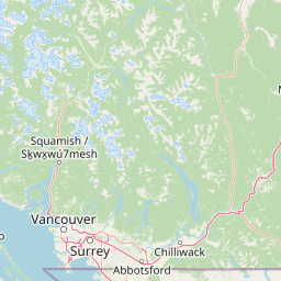
Map view of Kilby Provincial Park

Use this park location map to pinpoint Kilby Provincial Park in Canada, understand its exact geographic position, and read its mapped placement within the surrounding landscape more clearly.

Pigeon | © OpenStreetMap contributors

Location context for Kilby Provincial Park

British Columbia

Explore photographic records of the riverfront ecosystem, historic structures, and seasonal floodplain habitats

Kilby Provincial Park Photos and Scenery: Visualizing the Harrison River Landscape

Visual documentation captures the defining geography and seasonal changes across the protected Harrison River shoreline. Photographic records reveal the interplay between riparian wetlands, heritage structures, and wildlife habitats within the regional landscape.

A historic, two-story wooden building with scaffolding surrounding it, set against a backdrop of hazy, cloud-covered mountains.

Park atlas

Compare nearby regional parks and connected riverfront conservation areas across the Fraser Valley

Explore Other Parks Near Kilby Provincial Park and Surrounding Protected Landscapes

Browse protected areas and riverfront nature reserves located near Kilby Provincial Park in southwestern British Columbia. Expanding the search reveals surrounding regional geography and connected wildlife habitats across the wider Fraser Valley landscape.
State or regional parkBritish Columbia
About 14 km away#1 closest

East

Ferry Island Provincial Park: Geography, Riparian Terrain, and Protected River Boundaries

A study of Fraser River alluvial landscapes and provincial park land use

Ferry Island Provincial Park provides a rare protected island setting along the Fraser River in British Columbia. Spanning 29 hectares near the Agassiz-Rosedale Bridge, this Class C park represents an important alluvial riparian ecosystem within the heavily cultivated Fraser Valley, offering key insights into regional river-corridor geography and protected land management.

Area
0.29 km²
Established
1963
IUCN
II
Access
Access unknown
A watercolor painting showing a soft, hazy landscape of a lake with green forest along the shore and distant purple mountains under a pale sky.
State or regional parkBritish Columbia
About 21 km away#2 closest

West

Davis Lake Provincial Park: Protected Forest and Lake Geography in British Columbia

Regional protected area with old-growth forest and waterfalls

Davis Lake Provincial Park represents a significant protected area in the Fraser Valley, characterized by its undisturbed Western Hemlock forest and the scenic descent of Murdo Creek into McDonald Falls. The park provides an essential look at the regional geography of southwestern British Columbia, balancing dense coniferous canopy with accessible lake-based terrain in a quiet, natural setting.

Area
0.75 km²
Established
1963
IUCN
II
Relief
Upland
A watercolor painting showing a panoramic view of mountain peaks in the distance above green foothills and plains.
Protected landscapeWashington
About 26 km away#3 closest

South

Mount Baker, Snoqualmie National Forest: Mapped Geography and Protected Landscape Analysis

Exploratory atlas of Washington's primary Cascade Range wilderness

Delve into the structural geography of Mount Baker, Snoqualmie National Forest. This protected area corridor serves as a major ecological transition zone between the Puget Sound lowlands and the interior Cascades, characterized by extensive glaciers, wild river systems, and iconic stratovolcanoes that define the regional landscape of Washington state.

Area
6,978 km²
Established
1974
Relief
Mountain
Climate
Alpine
A soft watercolor painting of a landscape featuring a lake, low rolling hills in the background, and grassy vegetation along the foreground shoreline under a warm, pale yellow sky.
State or regional parkFraser Valley Regional District
About 31 km away#4 closest

West

Rolley Lake Provincial Park: An Atlas of Protected Landscapes and Regional Geography

Lakeshore forest terrain and protected park geography

Delve into the geographic identity of Rolley Lake Provincial Park, a state-protected landscape in the Fraser Valley Regional District. This documentation traces the park's internal map, including its central freshwater lake, loop trail connectivity, and surrounding second-growth forest topography, providing essential context for understanding this localized wilderness zone.

Area
1.15 km²
Established
1961
IUCN
II
A watercolor painting showing a soft-focus landscape with rolling green hills, distant mountains, and a central river or water feature.
State or regional parkBritish Columbia
About 31 km away#5 closest

Northwest

Golden Ears Provincial Park: Geographic Atlas and Protected Landscape Overview

Coast Mountains terrain and protected wilderness boundaries

Golden Ears Provincial Park is a major protected wilderness in British Columbia, defined by the twin peaks of the Golden Ears massif and vast glacial lake systems like Alouette and Pitt. This site serves as a vital ecological corridor where lowland forests meet high subalpine ridges. Explore the park through its mapped boundaries and diverse ecological zones within the Pacific Northwest mountain landscape.

Area
609 km²
Established
1967
IUCN
II
Visitors
956.5K annual
A horizontal watercolor painting showing a range of purple-tinted mountain peaks above a green forest and a light pinkish shoreline.
Wildlife reserveWashington
About 31 km away#6 closest

South

Mount Baker Wilderness: Mapped Volcanic Peaks and Glacial Geography in Washington State

Protected wilderness boundaries in the Northern Cascades

Mount Baker Wilderness encompasses a vast mountain landscape characterized by an active stratovolcano and significant permanent snowfields. The terrain features a vertical gradient from dense west side conifer forests to exposed alpine summits, creating a distinct ecological corridor connected to neighboring protected areas in the Pacific Northwest.

Area
485.58 km²
Established
1984
IUCN
Ib
Relief
Mountain
National parkWashington
About 41 km away#7 closest

Southeast

North Cascades National Park: US National Park Protected Landscape and Geographic Context

Explore mapped boundaries and regional Washington geography.

Gain insight into North Cascades National Park, a vital US National Park located in Washington. This entry focuses on its protected land status, mapped geographic extent, and its role within the regional atlas. Users seeking to understand the park's landscape character, natural terrain, and its specific location in Washington will find this an essential point for detailed park geography exploration and protected area discovery.

Area
2,042.26 km²
Established
1968
IUCN
II
Visitors
16.5K annual
A pale, minimalist watercolor illustration of a soft, hazy landscape featuring rolling mountains in the distance, low-lying green shrubs, and rocky terrain along a shoreline.
State or regional parkBritish Columbia
About 45 km away#8 closest

East

Coquihalla Canyon Provincial Park: A Deeply Eroded Granite Gorge in British Columbia

Mapping historic railway tunnels and river canyon landscapes

Trace the winding Coquihalla River as it cuts through ancient volcanic and metamorphic bedrock. This park preserves a unique intersection of industrial heritage and river morphology, showcasing four iconic tunnels bored through solid granite that define this section of the British Columbia interior landscape.

Area
1.59 km²
Established
1986
IUCN
III
Relief
Upland

Common questions about visiting, size, designation, and location context for Kilby Provincial Park

Kilby Provincial Park FAQs for park facts, access, geography, and protected area context

Find quick answers about Kilby Provincial Park, including protected-area facts, park geography, trail and visitor context, and how the park fits into its surrounding country and regional landscape.
MoriAtlas Explorer

Continue Your Protected Areas Search Across the Global Atlas

Deepen your exploration by continuing the structured search for national parks and protected areas worldwide. Utilize the comprehensive filtering capabilities to compare different conservation landscapes and refine your understanding of global park geography. Discover more about the distribution and characteristics of protected natural areas.

Global natural geography