

Mori Atlas logo
Nature reserveKing Range Wilderness

Mapping the dramatic vertical landscape where steep mountain ranges meet the Pacific Ocean shoreline

King Range Wilderness Nature Reserve: A Geographical Overview of California Coastal Terrain

King Range Wilderness represents a defining protected landscape in Humboldt County, California, characterized by its extreme coastal relief. This nature reserve rises abruptly from the Pacific shoreline to peaks over 4,000 feet within a few horizontal miles. The mapped area encompasses old-growth Douglas-fir forests, expansive coastal prairies, dune systems along the Mattole River, and a complex network of rocky headlands and sea stacks that define this remote stretch of the North Coast.

wilderness areaLost Coastcoastal mountainsPacific coastlineold-growth forestDouglas-fir forest

King Range Wilderness

Nature reserve

Park overview

Structured park overview, official facts, and landscape profile for King Range Wilderness

King Range Wilderness park facts, protected area profile, and essential visitor context

Review the core facts for King Range Wilderness, including designation, size, terrain, visitor scale, habitats, and operating context in one park-focused overview.

About King Range Wilderness

The King Range Wilderness anchors the heart of California's Lost Coast, a stretch of shoreline where terrain is so rugged that highways were routed inland, leaving the coast essentially free of roads and large-scale development. This remoteness preserved a remarkable concentration of natural character: sheer mountains plunging toward the Pacific, dense coastal forests, estuarine wetlands, and long sandy beaches that retain a wild and undeveloped character.

Geologically, the King Range belongs to the California Coast Ranges and exhibits some of the shortest horizontal distances between sea level and high peaks anywhere along the coast. This extreme vertical relief, combined with the nearby ocean, produces intense orographic rainfall, persistent summer fog, and a moist microclimate that supports lush vegetation and a unique assemblage of plant communities within a relatively small geographic footprint.

Ecologically, the wilderness protects four areas of particular botanical significance: old-growth Douglas-fir forest on the eastern slopes, the Mattole River dune system, undisturbed coastal prairie, and rare coastal stands of reedgrass. These habitats support large mammals such as black-tailed deer, black bear, mountain lion, and an introduced population of Roosevelt elk, as well as abundant seabirds along the offshore rocks and islands. Honeydew Creek, a tributary watershed within the broader conservation area, further protects habitat for bald eagles, northern spotted owls, mink, and anadromous fish.

Quick facts and research context for King Range Wilderness

The King Range Wilderness is a protected wilderness area in northern California, established in 2006 under the Northern California Coastal Wild Heritage Wilderness Act.

It covers approximately 42,585 acres across Humboldt and Mendocino Counties, and is managed by the Bureau of Land Management as part of the larger King Range National Conservation Area.

Protection and recognition

Documented conservation scope, management frameworks, and designation history

King Range Wilderness Protection Status and International Recognition Data

King Range Wilderness maintains a mixed protection scope governed by documented management frameworks and conservation standards. Recorded designation data outlines the official status and international recognition history associated with the protected landscape.

Protection details

Protection scope
Mixed
Transboundary protection
No
Park context

Deeper park guide and search-rich context for King Range Wilderness

King Range Wilderness history, landscape, wildlife, and travel context

Explore King Range Wilderness through its history, landscape character, ecosystems, wildlife, conservation priorities, cultural context, and seasonal travel timing in a structured park guide built for atlas discovery and search intent.

Why King Range Wilderness stands out

King Range is best known for the Lost Coast, the longest stretch of undeveloped coastline in the contiguous United States outside Alaska. Its landscape rises abruptly from the Pacific Ocean to elevations above 4,000 feet in just three miles, making it the most extreme coastal relief in California. The wilderness is also recognized for its ecological diversity in a compact area: old-growth Douglas-fir, dune ecosystems, coastal prairie, and the offshore Rocks and Islands Wilderness collectively support seabirds, marine mammals, Roosevelt elk, and threatened salmon populations.
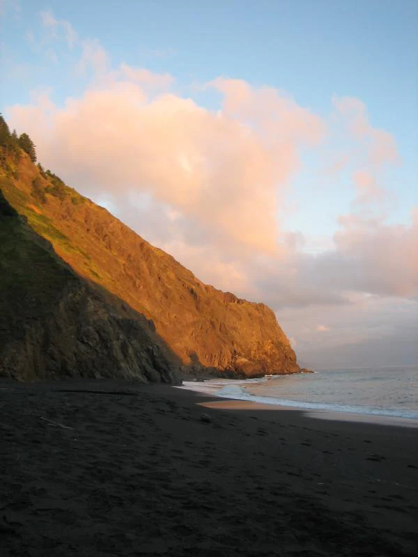
Sunset on the Lost Coast
Sunset view over the Lost Coast in Humboldt County, California.

King Range Wilderness history and protected-area timeline

The human history of the King Range reaches back more than two millennia. The earliest prehistoric sites along the coast date to roughly 2,800 years ago, possibly limited by geological uplift and soil erosion. Native American artifacts indicate settlement by the Wiyot people, later joined around AD 1100 by the Yurok. In more recent centuries, the Mattole, Sinkyone, and Bear River peoples lived in the region. From the late sixteenth century through the 1800s, Spanish, American, and Russian explorers and fur-trappers arrived, and by the 1880s, ranches and farms had developed to supply mining communities and growing settlements. Old homestead ruins and surviving orchards still dot the landscape.

The early twentieth century brought industrial-scale logging to the Douglas-fir forests, and Humboldt County became one of the largest timber-producing counties in California by the 1940s. Pressure to protect the coast began building as early as 1929, when President Herbert Hoover issued Executive Order 5237, withdrawing public parcels from settlement at the request of the state. California's Division of Beaches and Parks saw recreational potential, but the area remained unclassified through the 1950s.

Modern protection of the King Range took shape in the early 1960s. Congressman Clem Miller introduced legislation in 1961 to establish a national conservation area, drawing support from the Sierra Club and the local Mattole Action Committee. After Miller's death in 1962, Congressman Don Clausen continued the effort, and the King Range National Conservation Area was signed into law in 1970. The wilderness designation itself came decades later, in 2006, through the Northern California Coastal Wild Heritage Wilderness Act, which also created the tiny but ecologically important Rocks and Islands Wilderness offshore.

King Range Wilderness landscape and geographic character

The dominant physical feature of the King Range Wilderness is sheer coastal relief. The mountains belong to the California Coast Ranges, and in just about three miles of horizontal distance they rise from the Pacific shoreline to heights of more than 4,000 feet, the steepest coastal profile in the state. Canyons cut deeply into the range, draining short, steep rivers and creeks directly into the ocean.

Along the coast, the wilderness includes long sandy beaches, including the well-known Black Sands Beach, as well as rocky headlands, sea stacks, and the offshore rocks and islands of the California Coastal National Monument. Inland, the terrain moves through Douglas-fir forest, coastal prairie, oak woodlands, and the dune system of the Mattole River valley. The Mattole Estuary itself forms a transitional landscape where river and ocean meet, with meadows of accumulated sediment rising gradually toward the surrounding hills.

King Range Wilderness ecosystems, habitats, and plant life

The King Range supports an unusually dense mosaic of ecological communities given its compact size. Four botanical zones stand out: old-growth Douglas-fir forest on the east-facing slopes, the dune system along the lower Mattole River, undisturbed coastal prairie, and rare coastal stands of the state-listed reedgrass Calamagrostis foliosa. Tanoak and madrone have come to dominate much of the former old-growth Douglas-fir forest that was logged before BLM acquisition, while in some areas the Bureau of Land Management has undertaken active replanting, including large reforestation efforts in the Bear Trap Creek area.

Other characteristic plants include knobcone pine, Oregon grape, salal, manzanita, laurel, beargrass, and coastal oatgrass and bentgrass. The dune environment along the Mattole is a distinctive system shaped by both river sediment and coastal sand movement, while coastal prairie communities are among the rarest and least disturbed of their kind in California. Mushrooms, particularly matsutake under closed-canopy tanoak, also form a notable part of the forest ecosystem and have historical and contemporary cultural significance.

King Range Wilderness wildlife and species highlights

The King Range supports a wide array of terrestrial wildlife typical of California's humid north coast. Mammals include black-tailed deer, American black bear, mountain lion, and Roosevelt elk, the latter re-introduced into the area. Birdlife is rich and varied, reflecting the combination of forest, grassland, marine shoreline, and offshore islands: quail, grouse, doves, hawks, turkey vultures, and osprey occur alongside coastal seabirds that use the offshore rocks and islands as nesting and perching habitat.

The marine environment adds another layer of biodiversity. Harbor seals, Steller sea lions, California sea lions, and elephant seals use the rocky coastline and offshore rocks, while the Mattole River and its tributaries historically supported large runs of coho salmon and steelhead trout. The coho salmon population has declined sharply due to past logging, road building, and floods, and a distinct southern Oregon and northern California evolutionarily significant unit is federally listed as threatened. The Honeydew Creek Wildlife Preserve, within the broader conservation area, protects additional habitat of high conservation interest, including nesting areas for bald eagles and northern spotted owls, habitat for mink, and reaches used by anadromous fish.

King Range Wilderness conservation status and protection priorities

Conservation significance in the King Range stems from several interconnected factors: landscape preservation, watershed restoration, and offshore habitat protection. The Mattole River and its estuary were designated an Area of Critical Environmental Concern by the Bureau of Land Management in 1981, recognizing them as critical to salmonid recovery, estuarine habitat, and broader watershed health. Restoration efforts since the 1970s have addressed the legacy of road building, sedimentation, and canopy loss, including abandonment or reshaping of roads and long-term work to improve summer water temperatures for fish.

The offshore Rocks and Islands Wilderness, designated in 2006, plays a complementary role. It lies within the California Coastal National Monument, established by President Clinton in 2000 under the Antiquities Act of 1906 to protect islands, rocks, exposed reefs, and pinnacles above mean high tide within 12 nautical miles of the California shoreline. These offshore features form a narrow flight lane in the Pacific Flyway, providing critical nesting and perching habitat for millions of seabirds, and support endangered or threatened marine mammals including Steller sea lions and elephant seals.

Together, the terrestrial wilderness and the offshore wilderness represent a rare combined coastal conservation strategy, linking rugged onshore ecosystems and oceanic features under unified protected-area management.

King Range Wilderness cultural meaning and human context

The cultural landscape of the King Range reflects a prolonged history of human presence and use. Indigenous peoples including the Wiyot, Yurok, Mattole, Sinkyone, and Bear River peoples occupied or used these lands over many centuries, and indigenous plant use continues: beargrass, for instance, has long been harvested for basketry, and its protection has become a focus of environmental planning.

The more recent settlement period left scattered homesteads, ranching operations, and logging infrastructure that gradually gave way to conservation management. The historic Punta Gorda Lighthouse near the Mattole estuary stands as a tangible reminder of early coastal navigation and homesteading. Today, the area's cultural identity is closely tied to that sense of historical layering, from prehistoric coastal occupation through homesteading and timber booms, to the present era of wilderness conservation and community-led restoration efforts by nonprofit groups alongside public agencies.

Top sights and standout views in King Range Wilderness

The defining highlight of the King Range Wilderness is its dramatic vertical landscape: mountains rising more than 4,000 feet from the Pacific shoreline within a few lateral miles, creating one of the most striking coastal profiles in North America.

Equally notable is the area's ecological variety within a small footprint: old-growth Douglas-fir, dunes, coastal prairie, estuarine habitat, reedgrass stands, and offshore rocks and islands together host Roosevelt elk, northern spotted owls, bald eagles, harbor and Steller sea lions, and a federally threatened population of coho salmon. The adjacent Lost Coast Trail and the protected Mattole Estuary add both recreational and conservation value, making the area a significant natural and wild coastal landmark in the western United States.

Best time to visit King Range Wilderness

Given the area's heavy annual rainfall, with over 100 inches falling in the Mattole River valley and intense orographic storms affecting the highlands, drier months generally offer the most reliable conditions for coastal hiking and backpacking. Late spring through early fall typically offers lower precipitation and less stormy surf, though coastal fog remains a regular feature, moderating temperatures along the shoreline to roughly 60 degrees Fahrenheit even when inland temperatures exceed 100 degrees.

Visitors should be prepared for changeable weather at any time, with cool, foggy coastal mornings, warmer inland afternoons, and rapidly shifting conditions as storms sweep in off the Pacific. Creek crossings along the Lost Coast Trail can be challenging in the rainy season, so timing visits to drier months materially affects the experience of the backcountry.
Monthly climate preview

Track long-term monthly precipitation totals and temperature ranges across the representative coordinate.

King Range Wilderness Climate Normals and Average Temperature Profiles

Historical coordinate records track measured monthly temperature fluctuations and precipitation rhythms across the protected terrain. Analyzing twelve-month climatology data provides deeper insight into long-term averages for King Range Wilderness.
Annual mean12 °C
10 °C15 °C
Jan11°
Feb10°
Mar10°
Apr11°
May12°
Jun13°
Jul14°
Aug15°
Sep15°
Oct14°
Nov12°
Dec11°
Warmest month
September

14.7 °C

Coolest month
March

10.5 °C

Wettest month
December

8.5 mm/day

Driest month
August

0.2 mm/day

Park location guide

Geography guide, regional context, and park location map for King Range Wilderness

King Range Wilderness park geography, regions, and map view in United States of America

Understand where King Range Wilderness sits in United States of America through a broader geographic reading of the surrounding landscape, nearby location context, and its mapped position within the national park landscape.

How King Range Wilderness fits into United States of America

The United States of America is a federal presidential republic and one of the world's largest countries by area and population. It consists of 50 states across a vast territory spanning multiple time zones, with its capital in Washington, D.C. and largest city in New York City. The nation has a diverse economy, influential political system, and significant cultural and military presence globally.

Wider geography shaping King Range Wilderness in United States of America

The United States occupies a vast territory in North America, bordered by Canada to the north and Mexico to the south. The 48 contiguous states stretch from the Atlantic to the Pacific Ocean, while Alaska occupies the northwestern region and Hawaii is an archipelago in the Pacific. The country encompasses diverse terrain including the Rocky Mountains, Appalachian Mountains, Great Plains, and extensive river systems.

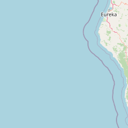
Map view of King Range Wilderness

Use this park location map to pinpoint King Range Wilderness in United States of America, understand its exact geographic position, and read its mapped placement within the surrounding landscape more clearly.

Pigeon | © OpenStreetMap contributors

Location context for King Range Wilderness

CaliforniaHumboldt CountyMendocino County

Visual reference of steep coastal relief, old-growth forests, and rugged Pacific terrain.

King Range Wilderness Photos and Scenery: Exploring the Lost Coast Landscape

Visual documentation of King Range Wilderness reveals the dramatic steep relief where coastal mountains rise abruptly from the Pacific shoreline. Photographic records capture old-growth Douglas-fir forests, river estuaries, and undeveloped beaches across the protected California landscape.

Sunset on the Lost Coast

Park atlas

Compare nearby coastal mountains, marine reserves, and regional wilderness tracts

Other Parks Near King Range Wilderness and Protected Areas Across California

Browsing protected areas near King Range Wilderness reveals connected coastal ecosystems and rugged California mountain ranges. Extending the geographic review helps map adjacent conservation lands and related natural terrain.
Protected areaCalifornia
About 49 km away#1 closest

North

Six Rivers National Forest: Exploring Protected River Valleys and Mountain Terrain in California

A regional protected area spanning California river systems

Six Rivers National Forest defines much of the rugged landscape in northwestern California. Named for the six major river drainages within its borders, the area features a unique combination of coastal forests, deep river canyons, and high-country ridges that offer significant insight into the region's broader geographic and ecological character.

Area
3,875.2 km²
Established
1947
Relief
Mountain
Climate
Mediterranean
Protected landscapeCalifornia
About 65 km away#2 closest

Northeast

Shasta, Trinity National Forest: Mapping the Protected Landscapes of Northern California

Volcanic peaks, expansive reservoirs, and rugged mountain wilderness

Spanning over two million acres, Shasta, Trinity National Forest represents a major protected landscape in Northern California. The geography includes the iconic Mount Shasta volcano and the complex shoreline of Shasta Lake, while hosting expansive wilderness areas and diverse terrain ranging from oak-forested foothills to alpine meadows.

Area
8,942.87 km²
Established
1954
Relief
Mountain
Climate
Temperate
Protected landscapeCalifornia
About 81 km away#3 closest

Southeast

Mendocino National Forest: Mapping California's Remote Protected Mountain Landscape

Examining wilderness boundaries and rugged coastal terrain

Mendocino National Forest serves as a significant protected area in California, known for being the only national forest in the state without major paved access. Its terrain spans 913,000 acres of mountain peaks, deep river canyons, and old-growth conifer forests. Home to the unique tule elk population at Lake Pillsbury, this landscape provides a rare example of wilderness isolation, complex geothermal features, and rugged, largely untouched northern coastal topography.

Area
3,696.02 km²
Established
1907
Relief
Mountain
Climate
Mediterranean
National parkCalifornia
About 103 km away#4 closest

North

Redwood National and State Parks: Protected Landscape Geography and Mapped Boundaries

Explore California's protected area atlas.

Gain a structured understanding of Redwood National and State Parks as a protected national park within the geographic context of California. This dedicated page focuses on its mapped boundaries and protected landscape identity, offering critical atlas-level insights for regional geography exploration and conservation land context. Discover how this protected area fits into the larger mapped terrain.

Area
562.88 km²
Established
1968
IUCN
V
Visitors
458.4K annual
Marine protected areaCalifornia
About 129 km away#5 closest

South

Greater Farallones National Marine Sanctuary: Protected Marine Geography and Atlas Data

Essential marine protected area off the coast of California.

Greater Farallones National Marine Sanctuary protects a vital network of oceanic habitats off California, including sandy beaches, tidal flats, subtidal reefs, and open ocean waters. This marine protected area serves as a critical link in the Pacific coast's network of conservation landscapes, offering a deep look at the geographic connectivity between coastal estuaries and offshore continental shelf environments.

Area
8,530 km²
Established
1981
Relief
Lowland
Climate
Mediterranean
Protected landscapeCalifornia
About 130 km away#6 closest

East

Whiskeytown, Shasta, Trinity National Recreation Area: Geographic and Protected Landscape Overview

Mapped terrain across northern California reservoir units

Investigate the environmental character of Whiskeytown, Shasta, Trinity National Recreation Area, spanning from the expansive waters of Shasta Lake to the forested ridges of the Whiskeytown unit. This atlas entry details the interplay between large-scale reservoir management, riparian habitats, and the transition from Mediterranean chaparral to high-elevation conifer forests in California.

Area
99,588 km²
Established
1965
IUCN
V
Visitors
1.5M annual
Protected landscapeCalifornia
About 147 km away#7 closest

Northeast

Marble Mountain Wilderness: Exploring Protected Mountain Landscapes in Northern California

Klamath Mountains Wilderness and Alpine Geography

Spanning hundreds of thousands of acres, Marble Mountain Wilderness offers a dense concentration of subalpine fir, deep glacial lakes, and steep drainage basins. This northern California protected landscape provides an atlas of rugged ridges and marble-toned peaks that represent one of the most ecologically diverse backcountry areas in the region.

Area
978.3 km²
Established
1964
IUCN
Ib
Relief
Mountain
Protected landscapeCalifornia
About 151 km away#8 closest

North

Smith River National Recreation Area: Mapping the Klamath Mountain Protected Landscape

Watershed geography and rugged mountain terrain in northwestern California

Located in the heart of the Klamath Mountains, Smith River National Recreation Area represents a critical protected watershed in northern California. The area is defined by its deep, forested canyons and the clean, wild waters of the Smith River, which serve as a primary link between coastal redwood ecosystems and mountainous inland terrain. Users can study the park boundaries and regional landscape characteristics that sustain this remote environment.

Area
1,235 km²
Established
1990
Relief
Mountain
Climate
Mediterranean

Common questions about visiting, size, designation, and location context for King Range Wilderness

King Range Wilderness FAQs for park facts, access, geography, and protected area context

Find quick answers about King Range Wilderness, including protected-area facts, park geography, trail and visitor context, and how the park fits into its surrounding country and regional landscape.
MoriAtlas Explorer

Continue Your Protected Areas Search Across the Global Atlas

Deepen your exploration by continuing the structured search for national parks and protected areas worldwide. Utilize the comprehensive filtering capabilities to compare different conservation landscapes and refine your understanding of global park geography. Discover more about the distribution and characteristics of protected natural areas.

Global natural geography