Mori Atlas logo
Nature reserveKoeberg Nature Reserve

Tracing the boundaries of threatened lowland ecosystems and coastal dune networks north of Cape Town

Koeberg Nature Reserve: A Protected Coastal Landscape and Hydrological Refuge in the Western Cape

Koeberg Nature Reserve functions as a critical protected buffer for unique lowland habitats on the Atlantic coast of the Western Cape. The reserve safeguards rare Atlantis Sand Fynbos and Cape Flats Dune Strandveld within a compact coastal footprint that integrates seasonal wetlands with dual aquifer systems. This mapped environment preserves significant botanical and wildlife communities against the unusual backdrop of commercial energy infrastructure.

Western Capecoastal reserveCape Flats Dune StrandveldAtlantis Sand Fynbosfynbosdune thicket

Koeberg Nature Reserve

Nature reserve

Park overview

Structured park overview, official facts, and landscape profile for Koeberg Nature Reserve

Koeberg Nature Reserve park facts, protected area profile, and essential visitor context

Review the core facts for Koeberg Nature Reserve, including designation, size, terrain, visitor scale, habitats, and operating context in one park-focused overview.

About Koeberg Nature Reserve

Koeberg Nature Reserve occupies a stretch of the Western Cape coast between Cape Town and the nearby inland regions to the north, set beside one of the most heavily developed urban edges in South Africa. Its roughly 26.8 square kilometre footprint packs in an unusually diverse mosaic of habitats, ranging from vegetated coastal dunes and seasonal wetlands to sandy fynbos plains and inland pan systems. The result is a small reserve that carries a disproportionately large share of the region's remaining natural character.

The reserve was proclaimed in 1991, primarily to act as a green buffer around the Koeberg Nuclear Power Station, the only commercial nuclear power station in South Africa. The buffer function is practical, helping shield the facility from erosion, wind, and surrounding land use pressure, but it has had the longer term effect of locking in a substantial area of natural habitat that might otherwise have been lost to the rapid growth of greater Cape Town. The reserve is managed by Eskom, the South African state-owned electricity utility that operates the power station.

Ecologically, the reserve is significant for the presence of two vegetation types that are considered endangered at a national level. Cape Flats Dune Strandveld is a coastal thicket and fynbos mosaic once common across the low-lying Cape Flats, while Atlantis Sand Fynbos is a sandy-substrate fynbos type found further inland on the sandveld. Both have been extensively transformed by agriculture, housing, and industry, and the patches preserved within Koeberg represent some of the remaining intact examples in the area.

Inland hydrology adds another layer of importance. The reserve overlies two aquifer systems, the Primary Sandveld Aquifer and the Malmesbury Aquifer, and contains a series of seasonal wetlands and open dams that concentrate wildlife particularly in wetter months. Coupled with a coastline that occasionally brings marine visitors close to shore, this gives the reserve both freshwater and marine influences unusual in a small inland reserve. The reserve sits adjacent to the Witzands Aquifer Nature Reserve, extending a corridor of conservation land across this sensitive coastal belt.

Quick facts and research context for Koeberg Nature Reserve

Koeberg Nature Reserve lies on the Western Cape coast of South Africa, about 30 kilometres north of Cape Town, and covers roughly 26.8 square kilometres of lowland terrain. The reserve was proclaimed in 1991 and is managed by Eskom, the state-owned utility that operates the adjacent Koeberg Nuclear Power Station. Its primary conservation role is to serve as a vegetated buffer around the nuclear facility while protecting the surrounding Cape Flats Dune Strandveld and Atlantis Sand Fynbos habitats.

The reserve contains wetlands, coastal dunes, and two aquifer systems, the Primary Sandveld Aquifer and the Malmesbury Aquifer. It protects habitat for more than 210 bird species, around 40 reptile species, and a varied mammal community that includes antelope, small carnivores, and visiting marine species. Its position next to the Witzands Aquifer Nature Reserve strengthens regional conservation connectivity along this part of the Western Cape coastline.

Protection and recognition

Documented terrestrial protection scope and historical designation data

Koeberg Nature Reserve Protection Status and Designation History

Koeberg Nature Reserve maintains documented terrestrial protection status established in nineteen ninety one. Protected area records compile the official designation history and management scope for this conservation landscape.

Protection details

Protection scope
Terrestrial
Designated year
1991
Transboundary protection
No
Park context

Deeper park guide and search-rich context for Koeberg Nature Reserve

Koeberg Nature Reserve history, landscape, wildlife, and travel context

Explore Koeberg Nature Reserve through its history, landscape character, ecosystems, wildlife, conservation priorities, cultural context, and seasonal travel timing in a structured park guide built for atlas discovery and search intent.

Why Koeberg Nature Reserve stands out

Koeberg Nature Reserve is best known for protecting two of South Africa's most threatened lowland ecosystems, the Cape Flats Dune Strandveld and Atlantis Sand Fynbos, in a single compact reserve north of Cape Town. It is unusual in being a formally proclaimed nature reserve that functions both as a buffer for a nuclear power station and as a refuge for highly localised vegetation types that have been severely reduced by urban expansion. The reserve is also recognised for its bird richness, with more than 210 recorded species, including threatened and range-restricted birds such as the African penguin, black harrier, and African oystercatcher. The combination of coastal dunes, seasonal wetlands, fresh water dams, and two aquifer systems gives the reserve an unusually high habitat diversity for its size, making it a significant site for Western Cape biodiversity conservation.
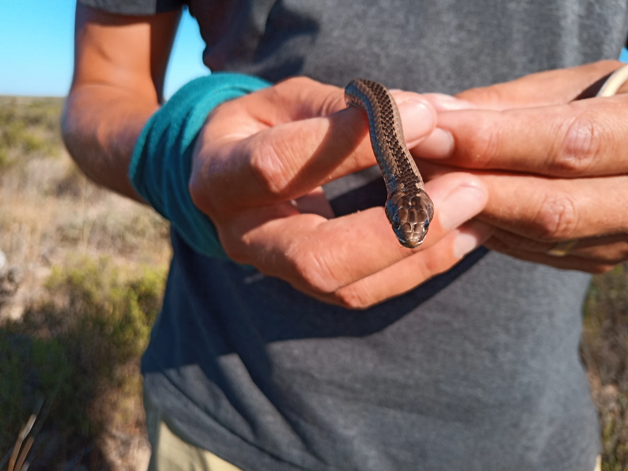
A person's hands holding a small Cross-marked Sand Snake with a patterned brown and tan body against a backdrop of shrubby vegetation and blue sky.
A Cross-marked Sand Snake (Psammophis crucifer) held gently in human hands at Koeberg Nature Reserve.

Koeberg Nature Reserve history and protected-area timeline

Koeberg Nature Reserve was formally proclaimed in 1991, several years after the construction and commissioning of the Koeberg Nuclear Power Station on the West Coast of South Africa. The reserve was established with a dual mandate: to create a vegetated buffer zone around the nuclear power station and to protect the natural environment surrounding the facility from further development pressure associated with Cape Town's northward expansion.

Management of the reserve has been retained by Eskom, the state-owned electricity utility that operates the nuclear power station. From its establishment, the reserve was framed less as a traditional wilderness park and more as a working conservation buffer, integrating habitat protection with the operational and safety requirements of the adjacent power station. Over time, the reserve's conservation value has grown, as urban growth around northern Cape Town has reduced the extent of many of the same vegetation types that Koeberg protects.

Cooperation between conservation authorities and Eskom has led to ongoing surveys of the reserve's amphibians, reptiles, birds, and mammals, and to the development of marked trails and bird hides for visitors. The reserve's position next to the Witzands Aquifer Nature Reserve has also reinforced its role as part of a broader network of coastal conservation land in the Western Cape.

Koeberg Nature Reserve landscape and geographic character

The landscape of Koeberg Nature Reserve is shaped by its position on the low-lying coastal belt north of Cape Town. Much of the reserve sits on sandy substrates that support Atlantis Sand Fynbos, a vegetation type characterised by fine-leaved shrubs, restios, and scattered proteas adapted to nutrient-poor sandy soils. Inland and along the coast, the substrate shifts toward the calcareous and shelly sands associated with Cape Flats Dune Strandveld, where low thicket and taller scrub form a distinctive dune mosaic.

Coastal dunes form one of the reserve's signature features, gradually rising from the beach inland and creating a transition between marine, dune, and fynbos environments. A salt pan lies within the dune system near the coast, and the smaller Grysbok Trail passes past it as it follows the shoreline. Inland, a series of seasonal wetlands and open dams break the otherwise dry sandy terrain, providing permanent fresh water that attracts wildlife and concentrates bird activity throughout the year.

The overarching scenery is open and gently undulating rather than mountainous. Visitors tend to encounter wide sandy tracks threading through fynbos and strandveld, sudden openings onto water surfaces and seasonal pans, and views of the Koeberg Nuclear Power Station's cooling towers marking the industrial context in which this reserve is set. The combination of wild coastal scenery and visible infrastructure is one of the most distinctive features of the landscape.
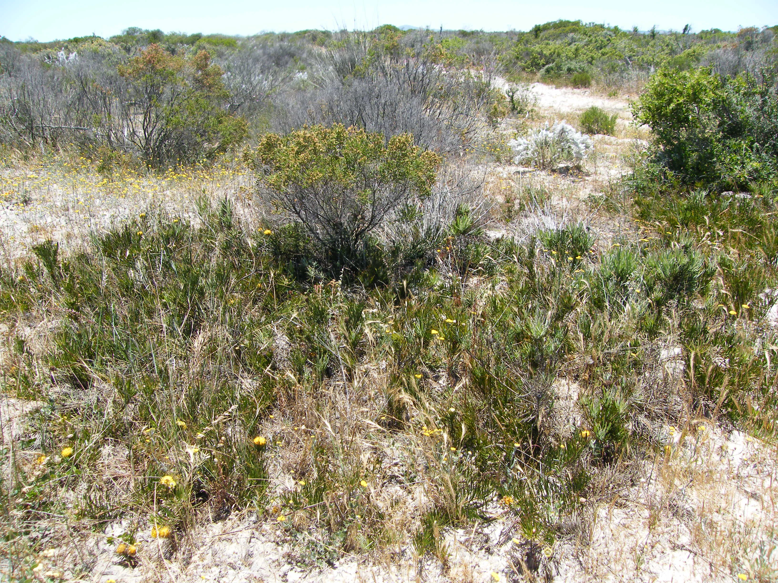
A wide shot of a gray snakestem pincushion bush surrounded by dry grass and other shrubs in a sandy landscape.
Gray snakestem pincushion bush in the Koeberg Nature Reserve

Koeberg Nature Reserve ecosystems, habitats, and plant life

Koeberg Nature Reserve protects an unusually rich concentration of lowland ecosystems for its size. The single most important feature of the reserve's natural character is the preservation of two nationally endangered vegetation types: Cape Flats Dune Strandveld, found along the dunes and coastal fringe, and Atlantis Sand Fynbos, which dominates the inland sandy plains. These vegetation types have been heavily transformed elsewhere in the Cape Town region, making the patches preserved at Koeberg ecologically significant even in their fragmented state.

The reserve's habitat mosaic extends well beyond its terrestrial plant communities. Seasonal wetlands and open dams create fresh water habitats that shift in size and quality through the year, feeding into two underlying aquifer systems, the Primary Sandveld Aquifer and the Malmesbury Aquifer. The interplay between surface water, sandveld substrate, and coastal influence means the reserve supports a layered ecological structure, from root systems adapted to deep sandy soils, through restio and bulb-dominated fynbos layers, to thicket canopies along the dune belt.

Faunal diversity mirrors the habitat variety. The reserve's combination of dune thicket, open fynbos, wetlands, and open water provides niches for amphibians associated with seasonal pans, reptile communities adapted to sandy substrates, and a wide array of birds ranging from fynbos specialists to waterbirds that appear when conditions are right. Even marine influences reach the reserve when conditions and seasons bring certain coastal and pelagic species into view from the shoreline.

Koeberg Nature Reserve wildlife and species highlights

The reserve's wildlife profile is strikingly broad for a small protected area. Birdlife is the most celebrated component, with more than 210 species recorded within the reserve's boundaries. Common fynbos and thicket species such as the Cape bulbul, Cape robin-chat, bokmakierie, Karoo scrub robin, Karoo prinia, southern double-collared sunbird, and yellow canary are present, alongside waterbirds attracted to the reserve's dams and seasonal pans. The reserve also supports near threatened species such as the great white pelican and African oystercatcher, the endangered black harrier, and the vulnerable African penguin, the latter reflecting the reserve's coastal location.

Mammal communities include a mix of small carnivores, antelope, and larger plains species, an unusual combination for a reserve of this size near a major city. The list includes African wildcat, bat-eared fox, Cape grey mongoose, caracal, small-spotted genet, and several duikers, alongside larger grazers such as blue wildebeest, Burchell's zebra, common eland, gemsbok, springbok, and steenbok. The presence of these larger species suggests active management to maintain the open conditions that many of them prefer. The southern right whale also appears in the offshore marine zone adjacent to the reserve.

Reptile diversity is another notable feature, with around 40 recorded species. The list includes threatened forms such as the Bloubergstrand dwarf burrowing skink, Gronovi's dwarf burrowing skink, and the southern adder, alongside common snakes such as the mole snake, rhombic egg-eater, red-lipped herald, spotted skaapsteker, and the cross-marked grass snake. Although most snake species in the reserve are not dangerous, the Cape boomslang and Cape cobra are both present and need to be treated with caution. Eight amphibian species have been documented, reflecting the importance of the reserve's seasonal wetlands for this group.

Koeberg Nature Reserve conservation status and protection priorities

Koeberg Nature Reserve holds significant conservation value because it protects two of South Africa's most threatened lowland vegetation types within a single boundary. Cape Flats Dune Strandveld and Atlantis Sand Fynbos have been heavily reduced by urban expansion, agriculture, and industrial development around Cape Town, and reserves that retain intact examples of both are now nationally important. Koeberg's role in safeguarding these vegetation types is therefore disproportionate to its modest size.

The reserve also contributes to conservation of freshwater systems in the region. Its two underlying aquifers, the Primary Sandveld Aquifer and the Malmesbury Aquifer, and its seasonal wetlands form part of a wider hydrological network that supports both natural ecosystems and human water supply. Protecting the land above these aquifers helps maintain infiltration and reduces contamination risks, while the dams and pans sustain resident and seasonal wildlife.

From a threatened-species perspective, the reserve provides habitat for several formally recognised conservation priorities. These include the endangered black harrier and the vulnerable African penguin among birds, the Bloubergstrand dwarf burrowing skink and Gronovi's dwarf burrowing skink among reptiles, and the southern adder. The reserve's adjacency to the Witzands Aquifer Nature Reserve extends this conservation role into a broader landscape context, reinforcing connectivity along the Western Cape coast.

Top sights and standout views in Koeberg Nature Reserve

Koeberg Nature Reserve stands out for the way it compresses a remarkable range of lowland habitats into a relatively small coastal reserve. The combination of Cape Flats Dune Strandveld, Atlantis Sand Fynbos, coastal dunes, seasonal wetlands, and two aquifer systems makes it a stronghold for vegetation types that have disappeared from much of the surrounding Cape Town metropolitan area. Few reserves in the region match its combination of dune, fynbos, and wetland habitats in one accessible footprint.

The reserve's bird list of more than 210 species gives it another distinctive highlight, particularly for a reserve this close to a major city and a major industrial facility. The presence of endangered and vulnerable species such as the black harrier and African penguin, and the unusual inclusion of larger plains mammals like blue wildebeest, Burchell's zebra, gemsbok, and common eland, add further distinction. Its setting against the visible cooling towers of the Koeberg Nuclear Power Station creates a unique cultural-landscape backdrop that visitors do not encounter at more typical wilderness reserves.

Best time to visit Koeberg Nature Reserve

Koeberg Nature Reserve can be visited throughout the year, but conditions vary meaningfully with the seasons. The Western Cape's wetter winter and early spring months, generally from around May to September, bring cooler temperatures, greener fynbos conditions, and fuller seasonal wetlands, which tend to concentrate bird activity around the reserve's dams and pans. This is often a productive period for both birdwatching and viewing the fynbos at its most lush.

The warmer, drier summer months from October to March offer drier trails, longer daylight hours, and easier walking conditions, though vegetation appears more parched and bird activity around water sources becomes more concentrated. Summer also brings increased chances of marine sightings from the coastline, including southern right whales during their winter to early spring season. Visitors interested in the reserve's reptiles will generally find warmer months more rewarding, when these animals are most active.
Monthly climate preview

Long-term temperature and precipitation records measured at representative coordinates

Koeberg Nature Reserve Climate Normals and Annual Weather Patterns

Koeberg Nature Reserve exhibits a measured annual rhythm defined by warm summer peaks and milder winter months alongside shifting precipitation averages. Reviewing the complete twelve-month dataset provides a detailed baseline of long-term temperature and precipitation normals for the reserve.
Annual mean17 °C
14 °C20 °C
Jan20°
Feb20°
Mar19°
Apr17°
May16°
Jun14°
Jul14°
Aug14°
Sep15°
Oct16°
Nov18°
Dec19°
Warmest month
February

20.4 °C

Coolest month
July

13.8 °C

Wettest month
June

2.7 mm/day

Driest month
February

0.3 mm/day

Park location guide

Geography guide, regional context, and park location map for Koeberg Nature Reserve

Koeberg Nature Reserve park geography, regions, and map view in South Africa

Understand where Koeberg Nature Reserve sits in South Africa through a broader geographic reading of the surrounding landscape, nearby location context, and its mapped position within the national park landscape.

How Koeberg Nature Reserve fits into South Africa

South Africa is the southernmost country in Africa, spanning 1.22 million km² with a population of over 63 million. The country operates with three capital cities, Pretoria (executive), Cape Town (legislative), and Bloemfontein (judicial), and is renowned for its biodiversity, national parks, and multicultural society.

Wider geography shaping Koeberg Nature Reserve in South Africa

South Africa occupies the southernmost region of Africa, with coastline along both the Atlantic Ocean to the west and the Indian Ocean to the east. The interior features elevated plateaus including the Highveld, with the Drakensberg escarpment marking the eastern highlands. The country shares borders with Namibia, Botswana, Zimbabwe, Mozambique, Eswatini, and Lesotho.

Map view of Koeberg Nature Reserve

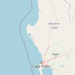
Use this park location map to pinpoint Koeberg Nature Reserve in South Africa, understand its exact geographic position, and read its mapped placement within the surrounding landscape more clearly.

Pigeon | © OpenStreetMap contributors

Location context for Koeberg Nature Reserve

Western Cape

Visual reference of coastal dunes, fynbos habitats, and protected strandveld ecosystems

Koeberg Nature Reserve Photos and Landscape Scenery Visual Exploration

Visual records capture the distinctive landscape, native fynbos, and fragile coastal habitats protected within the reserve boundaries. Detailed photography reveals the unique ecological balance between vulnerable lowland ecosystems and adjacent industrial infrastructure along the coast.

A person's hands holding a small Cross-marked Sand Snake with a patterned brown and tan body against a backdrop of shrubby vegetation and blue sky.

Close-up of a bright yellow pincushion flower with dense tubular florets, surrounded by green stems, growing in sandy soil with dry vegetation.

A wide shot of a gray snakestem pincushion bush surrounded by dry grass and other shrubs in a sandy landscape.

Park atlas

Compare adjacent lowland ecosystems and connected conservation landscapes across the region

Parks Near Koeberg Nature Reserve and Surrounding Coastal Protected Areas

Browse other parks and protected areas near Koeberg Nature Reserve to examine similar coastal fynbos and dune habitats. Comparing these regional reserves reveals the broader ecological spread of the Western Cape coastal belt.
National parkWestern Cape
About 29 km away#1 closest

South

Table Mountain National Park: Mapped Protected Landscape and Geographic Context in Western Cape

National Park details focused on atlas exploration and regional geography.

Table Mountain National Park is a designated national park within the Western Cape region, offering a distinct geographic profile for atlas exploration. This entity provides detailed mapped boundaries and landscape context, crucial for understanding its role as a protected area in South Africa. Users can explore the specific geography that defines this park and its place within the broader regional context, making it a key point of interest for structured geographic discovery and map-based research.

Area
221 km²
Established
1998
Relief
Mountain
Climate
Mediterranean
Nature reserveCape Town
About 30 km away#2 closest

Southeast

Tygerberg Nature Reserve: Geographic Mapping of a Cape Town Protected Landscape

Renosterveld shale ridges and urban conservation context

Tygerberg Nature Reserve stands as a compact, high-value protected area within Cape Town, safeguarding hundreds of plant species and threatened Renosterveld habitats. The park landscape features a recognizable chain of shale hills punctuated by historic termite mounds known as heuweltjies, offering a window into the regional ecology and natural history of the Western Cape.

Area
3 km²
Established
1973
Relief
Upland
Climate
Mediterranean
A watercolor painting showing a soft, panoramic landscape with green hills in the background, a body of water in the middle ground, and grasses in the foreground.
Nature reserveWestern Cape
About 38 km away#3 closest

Northwest

Dassen Island Nature Reserve: Atlantic Geography and Protected Area Overview

Coastal refuge and protected granite-based Atlantic island

Located in the cold waters off the Western Cape, Dassen Island is a proclaimed nature reserve and Ramsar wetland. This flat Atlantic landmass is characterized by its granitic reef structure and long-established role as a sanctuary for African penguins and other seabird populations. The island represents a convergence of maritime history and marine conservation, offering a unique geographic perspective on South Africa's coastal wilderness.

Area
2.6 km²
Established
2019
Relief
Lowland
Climate
Mediterranean
National parkWestern Cape
About 44 km away#4 closest

Northwest

West Coast National Park: A National Park's Mapped Boundaries and Geographic Identity

Explore its protected landscape within the Western Cape region.

West Coast National Park is a protected national park situated in the Western Cape province of South Africa. This dedicated page provides a structured view of its geographic scope, emphasizing its mapped boundaries and its significance as a protected landscape within the region's broader atlas context. Gain insight into the park's distinct natural terrain and regional geography.

Area
362.59 km²
Established
1985
Climate
Mediterranean
Access
Easy access
Biosphere reserveWestern Cape
About 54 km away#5 closest

East

Cape Winelands Biosphere Reserve: Geographic Overview and Protected Area Mapping

Western Cape mountain terrain and sustainable landscape integration

The Cape Winelands Biosphere Reserve serves as a model for integrated landscape management in South Africa. Situated along the Cape Fold Belt, this reserve protects crucial water catchments and endemic floral habitats while encompassing a globally recognized wine-producing region. Access detailed mapping of its core, buffer, and transition zones to see how conservation persists within a working agricultural environment.

Area
1,243.4 km²
Established
2007
Relief
Mountain
Climate
Mediterranean
Watercolor painting of a soft, hazy mountain landscape with rolling green hills and pink-toned foreground vegetation, presented in a wide panoramic aspect.
Biosphere reserveWestern Cape
About 58 km away#6 closest

South

Cape Floristic Region: A Detailed Geographic Atlas of the Western Cape Biodiversity Hotspot

Mapped protected biosphere reserve and fynbos landscapes

Explore the Cape Floristic Region, an expansive protected landscape within South Africa. This atlas provides a detailed look at the region's Mediterranean shrublands, sandstone-derived soil terrain, and its status as a singular floral kingdom. Understand the geography of the Western Cape through its mountain ranges and diverse ecological zones.

Area
78,555 km²
Established
2004
Watercolor painting of a mountain landscape with green foreground hills and soft purple mountain ranges in the background.
Nature reserveWestern Cape
About 59 km away#7 closest

Southeast

Jonkershoek Nature Reserve: A Detailed Atlas of Mountain Catchment and Fynbos Ecology

Protected mountain geography near Stellenbosch, Western Cape

Jonkershoek Nature Reserve serves as a primary water source for the surrounding Western Cape landscape. This profile outlines the reserve's role in the Cape Floral Region, detailing its complex mountain topography, river headwaters, and significant fynbos plant communities that characterize the terrain.

Area
110 km²
Relief
Mountain
Climate
Mediterranean
Access
Easy access
A watercolor illustration of a wide landscape featuring a calm body of water in the foreground, rolling green hills, and purple-toned mountains in the background.
Nature reserveWestern Cape
About 85 km away#8 closest

Southeast

Kogelberg Nature Reserve: Protected Mountain Geography in the Western Cape, South Africa

Coastal mountain fynbos and protected river ecosystems

Situated in the Western Cape of South Africa, Kogelberg Nature Reserve protects an exceptional concentration of fynbos vegetation and rugged sandstone terrain. The area spans coastal mountain ridges, riparian corridors, and forest-filled ravines, serving as a landmark for botanical diversity and protected-landscape mapping in the region.

Area
30 km²
Relief
Mountain
Scope
Terrestrial
Water
Major water bodies

Common questions about visiting, size, designation, and location context for Koeberg Nature Reserve

Koeberg Nature Reserve FAQs for park facts, access, geography, and protected area context

Find quick answers about Koeberg Nature Reserve, including protected-area facts, park geography, trail and visitor context, and how the park fits into its surrounding country and regional landscape.
MoriAtlas Explorer

Continue Your Protected Areas Search Across the Global Atlas

Deepen your exploration by continuing the structured search for national parks and protected areas worldwide. Utilize the comprehensive filtering capabilities to compare different conservation landscapes and refine your understanding of global park geography. Discover more about the distribution and characteristics of protected natural areas.

Global natural geography