
Mori Atlas logo
Nature reserveKoffituten

Discover the complex mosaic of peatland, pine-oak woodland, and fen forest in this protected German landscape.

Koffituten Nature Reserve: A Mapped Study of Raised Bog Regeneration and Inland Dune Terrain

Koffituten represents a rare, small-scale example of successful raised bog restoration in the Steinfurt district of North Rhine-Westphalia. This nature reserve serves as an ecologically vital protected landscape, featuring a unique transition from moisture-rich Hochmoor cores to sandy inland dune ridges and pine-oak woodlands. By examining its boundaries and terrain, observers can trace the successful recovery of peatland ecosystems within the broader geography of northwestern Germany.

raised bogHochmoorpeatlandbog restorationinland dunespine-oak woodland
A flat vector illustration of a meadow framed by birch and oak trees in the foreground, with a pine forest, distant mountains, and a waterfall in the background.

Koffituten

Nature reserve

Park overview

Structured park overview, official facts, and landscape profile for Koffituten

Koffituten park facts, protected area profile, and essential visitor context

Review the core facts for Koffituten, including designation, size, terrain, visitor scale, habitats, and operating context in one park-focused overview.

About Koffituten

Koffituten lies in the northwestern German region known as the Tecklenburger Land, within the broader Münsterland, where glacial and post-glacial sand deposits have produced a landscape rich in moors, inland dunes, and mixed woodland. The reserve sits near the village of Schale in the municipality of Hopsten, a rural area dominated by agriculture, forestry, and a network of small protected sites scattered among fields and forests.

The identity of the place is rooted in its peatland character. The Hochmoor at the heart of the reserve formed several thousand years ago when a shallow lake filled in and organic matter began to accumulate, eventually building a peat deposit of roughly two meters thick. Over centuries this peat body grew into a raised dome, with vegetation sustained entirely by rainfall rather than groundwater. Even after decades of drainage and woodland encroachment, the bog retained enough viable Hochmoor vegetation that active restoration could bring it back to life.

Surrounding the bog core is a varied landscape mosaic that gives the reserve additional ecological value. Inland dunes, formed from windblown sand during earlier climatic phases, rise above parts of the area and support dry, species-poor pine and oak woodlands. Wetter areas transition into moor woodland and scrub, and beyond the protected zone lie extensive meadows. Together these elements form a coherent ecological unit, and the reserve is embedded in the Schaler Naturerlebnisweg, a local nature-discovery trail that connects visitors with the region's varied terrain.

Although small in size, Koffituten carries significance well beyond its boundaries because it is one of very few remaining living raised bogs in the district and because it is formally integrated into the European Natura 2000 network. Its restoration demonstrates how targeted rewetting and vegetation management can revive even degraded peatlands, providing a reference point for conservation work elsewhere in the region.

Quick facts and research context for Koffituten

Koffituten is a nature reserve of approximately 23.55 hectares located near the village of Schale in the municipality of Hopsten, within the Steinfurt district of North Rhine-Westphalia. The site carries the German protected-area designation ST-078 and forms part of the European Natura 2000 network as a Habitats Directive site (DE-3511-301).

At its heart lies one of the last surviving raised bogs, or Hochmoore, in the Steinfurt district. The bog core covers less than half a hectare, while the remainder of the reserve consists of woodland, scrub, and grassland surrounding the peat body. The protection status was officially established in 1991 by the Steinfurt district administration.

Protection and recognition

Explore terrestrial protection records, management scope, and Natura 2000 listings.

Koffituten Protection Status and Documented International Recognition

Koffituten maintains documented terrestrial protection status alongside verified Natura 2000 recognition records. Structured administrative data details the official designation scope and conservation framework.

International recognition

Protection details

Protection scope
Terrestrial
Transboundary protection
No
Park context

Deeper park guide and search-rich context for Koffituten

Koffituten history, landscape, wildlife, and travel context

Explore Koffituten through its history, landscape character, ecosystems, wildlife, conservation priorities, cultural context, and seasonal travel timing in a structured park guide built for atlas discovery and search intent.

Why Koffituten stands out

Koffituten is best known for containing one of the last living raised bogs in the Steinfurt district and for serving as a small-scale example of successful bog regeneration in the lowlands of North Rhine-Westphalia. The reserve's defining feature is its combination of habitats: a compact but intact Hochmoor surrounded by inland dunes, moor woodland, and pine-oak forest. This mosaic supports rare bog plants such as round-leaved sundew and crowberry, along with threatened fauna that depend on the specialized conditions of an actively growing peat surface. The site's inclusion in the EU Natura 2000 network underscores its regional importance for the conservation of endangered bog ecosystems.
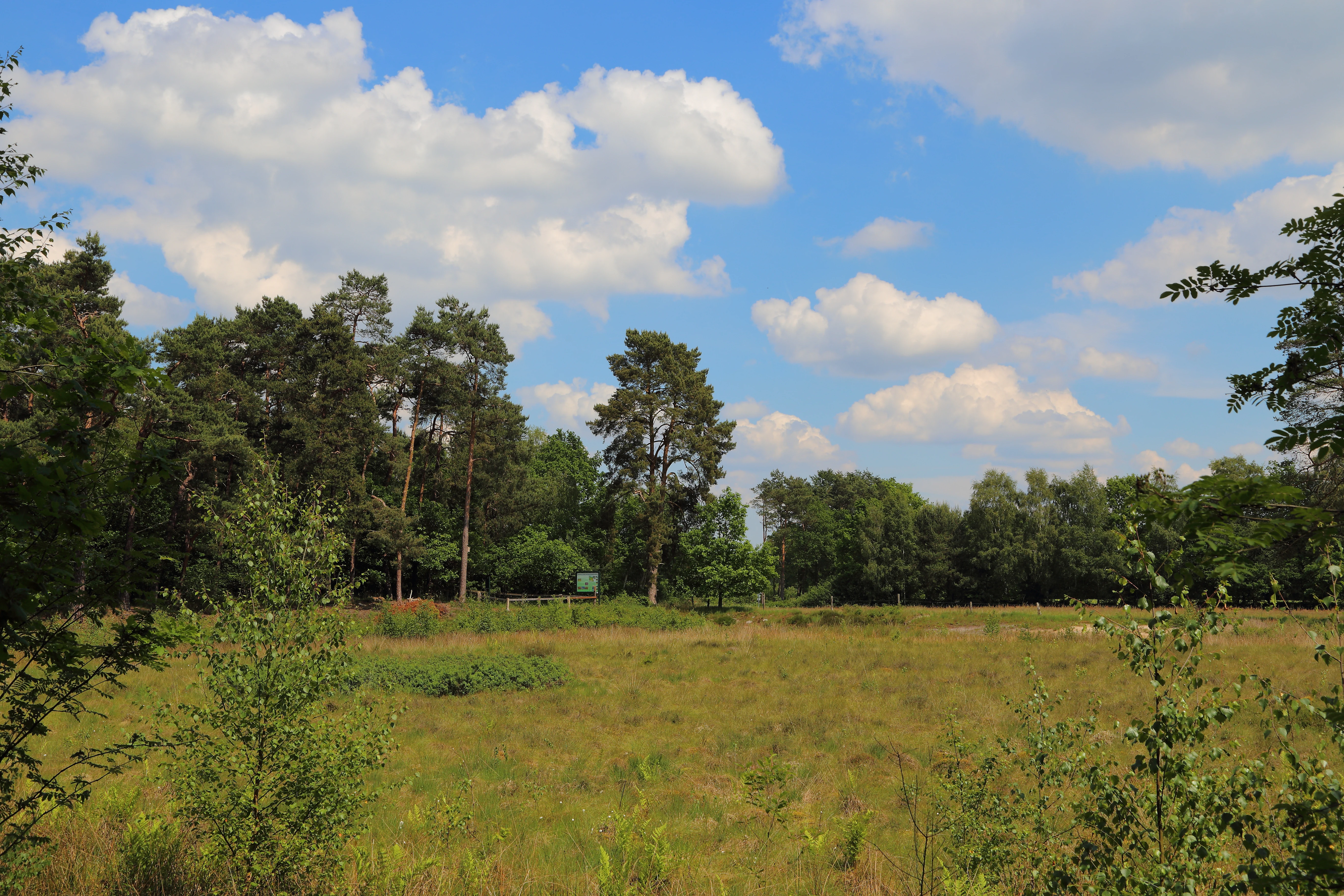
A wide view of an open bog or moorland area with grasses in the foreground, backed by a line of trees against a blue sky with white clouds.
The open moor landscape and bordering woodland in the Koffituten nature reserve.

Koffituten history and protected-area timeline

The Koffitutenmoor began to form roughly five thousand to five and a half thousand years ago, when a shallow body of water gradually filled with organic material and transformed into a peatland. Over millennia, plant remains accumulated to a depth of around two meters, creating a characteristic raised bog sustained by rainfall rather than groundwater.

During the middle of the twentieth century, drainage measures lowered the water table across the bog, causing the peat to subside and allowing birch and pine trees to colonize the surface. These woody invaders suppressed the open bog vegetation that had previously defined the site. By the early 1990s, the surviving Hochmoor vegetation was limited to a fragmented core of less than half a hectare.

In 1991, the Steinfurt district administration placed the bog and surrounding land under formal nature protection, assigning the site the official designation ST-078. Conservation work followed: invading trees and scrub were removed from the peat surface, and old drainage ditches were blocked to allow water levels to rise again. These measures led to a noticeable revival of the Hochmoor, with specialized bog plants re-establishing themselves on the rewetted surface. The site's inclusion in the EU Natura 2000 network, under the Habitats Directive as area DE-3511-301, reflected its broader significance for European peatland conservation.

The unusual name Koffituten, according to local accounts, derives from the Low German word for conical paper bags in which coffee beans were once sold. The shape of the small bog is said to have reminded earlier residents of these pointed coffee cones, giving the protected area its distinctive toponym.

Koffituten landscape and geographic character

The landscape of Koffituten is shaped by the interplay of peatland, sand, and woodland. At its center lies a small raised bog, only about half a hectare in extent, where rainwater-fed peat has built up over thousands of years into a gently domed surface. Around this core, the terrain transitions into a mosaic of drier and wetter habitats typical of the northern Münsterland.

Inland dune ridges, formed by windblown sand during earlier phases of the post-glacial period, rise subtly across parts of the area and support open pine and oak forests with sparse undergrowth. Where moisture increases toward the bog, the woodland shifts into denser, darker moor forest, dominated by species adapted to acidic, waterlogged soils. Beyond the protected boundary, the land opens up into broad grassland areas that surround the reserve on most sides.

The result is a compressed but ecologically varied scene: a compact bog island set within a matrix of dune woodland, fen forest, and pasture. Despite its modest size, this combination gives the reserve a clear sense of place and makes the surrounding trail a walk through multiple distinct landscapes within a short distance.

Koffituten ecosystems, habitats, and plant life

The ecological character of Koffituten is defined by its rare combination of actively growing raised bog, inland dune vegetation, and bog-margin woodland. Although the area is small, it preserves a sequence of habitats that have largely disappeared elsewhere in the Steinfurt district, making it disproportionately important for regional biodiversity.

At the core, the rewetted peat surface supports the specialized vegetation of a living Hochmoor. Sphagnum mosses and other peat-forming species have re-established themselves since the restoration effort began in the 1990s, creating conditions suitable for insectivorous plants and other bog specialists. The surrounding drier soils host acid-tolerant communities typical of inland dunes, with scattered pines and oaks and a sparse herb layer adapted to nutrient-poor conditions. The wet transitional zones between bog and forest support a distinct set of moisture-loving shrubs and trees that form the moor woodland fringe.

Conservation management at the site focuses on keeping trees and scrub from reclaiming the open bog, maintaining high water levels, and preventing further degradation of the peat body. The presence of the Natura 2000 designation also obliges long-term monitoring of habitat condition and the species associated with these fragile environments.

Koffituten wildlife and species highlights

The wildlife of Koffituten reflects the unusual mix of bog, dune, and woodland habitats within a very small footprint. The active peat surfaces and their associated plant communities provide habitat for invertebrates specialized in cool, wet, acidic conditions, including the prey base for rare bog-dwelling insects. These small creatures, in turn, sustain birdlife and other fauna that rely on the reserve for feeding and nesting.

In the drier inland dune woodland, bird species typical of open pine forest find refuge among the scattered trees, while the wetter margins and surrounding meadows support a wider community of woodland and grassland birds. The combination of microhabitats within such a small area makes the reserve valuable for species that would otherwise struggle in the more uniform agricultural landscape of the surrounding Münsterland.

Although the source material does not detail specific animal species at length, the site's Natura 2000 status and its active bog restoration indicate ongoing attention to maintaining conditions for threatened fauna associated with peatlands and acidic woodland.

Koffituten conservation status and protection priorities

Koffituten is a conservation site of regional and European significance, primarily because it protects one of the last living raised bogs in the Steinfurt district within a landscape where most similar peatlands have been drained, cultivated, or afforested. The site was placed under formal nature protection in 1991 by the Steinfurt district, with the designation ST-078.

The reserve is also part of the European Natura 2000 network under the EU Habitats Directive (site code DE-3511-301), linking its protection to broader continental efforts to conserve threatened habitat types. This international recognition reflects the importance of the remaining active peat-forming communities and the associated dune and bog-forest habitats for biodiversity conservation across Europe.

Active management at Koffituten focuses on rewetting, removal of invading trees and scrub from the peat surface, and ongoing monitoring of habitat quality. The successful revival of the bog after decades of drainage is often cited locally as an example of how careful restoration can bring even small, degraded peatlands back into a more natural state.

Koffituten cultural meaning and human context

The cultural dimension of Koffituten is modest but distinctive. Its name, recorded in local tradition as Low German for conical paper bags once used to sell coffee beans, reflects the rural folk customs of the Münsterland region. The physical resemblance of the small bog to these pointed coffee cones gave the protected area its enduring local identity.

The reserve is also tied to the broader rural culture of the Schale area, where small protected sites are part of the everyday landscape of farming villages. The integration of the reserve into the Schaler Naturerlebnisweg reflects a regional tradition of linking conservation with public nature education and low-impact outdoor recreation.

Top sights and standout views in Koffituten

Highlights of Koffituten include its status as one of the last living raised bogs in the Steinfurt district, its successful bog-restoration story since 1991, and the compact mosaic of raised bog, inland dunes, and pine-oak woodland that defines the site. The reserve's formal integration into the European Natura 2000 network underlines its ecological importance beyond the local region.

Best time to visit Koffituten

The reserve can be experienced year-round through the Schaler Naturerlebnisweg, but spring and early summer are particularly rewarding for observing the open bog surface, its specialized plant life such as sundew, and the contrast between wet peatland and surrounding woodland. Late summer and autumn bring quieter conditions and a more muted color palette across the bog and dune woodlands.


Monthly climate preview

Track monthly temperature variations and precipitation averages for Koffituten

Koffituten Climate Normals: Long Term Temperature and Precipitation Patterns

Representative coordinates record measured long-term temperature ranges alongside consistent monthly precipitation values across the protected terrain. Analyzing complete twelve-month normals provides deeper context for regional climate patterns without relying on live forecasts.
Annual mean10 °C
1 °C18 °C
Jan
Feb
Mar
Apr
May13°
Jun16°
Jul18°
Aug18°
Sep14°
Oct10°
Nov
Dec
Warmest month
July

18.2 °C

Coolest month
January

1.4 °C

Wettest month
December

2.4 mm/day

Driest month
April

1.4 mm/day

Park location guide

Geography guide, regional context, and park location map for Koffituten

Koffituten park geography, regions, and map view in Germany

Understand where Koffituten sits in Germany through a broader geographic reading of the surrounding landscape, nearby location context, and its mapped position within the national park landscape.

How Koffituten fits into Germany

Germany is a federal republic in Western and Central Europe with a population of over 83 million across sixteen constituent states. It is Europe's largest economy by nominal GDP and a major global exporter and importer. The capital is Berlin, and the country borders Denmark, Poland, Czech Republic, Austria, Switzerland, France, Luxembourg, Belgium, and the Netherlands.

Wider geography shaping Koffituten in Germany

Germany is located in Western and Central Europe, spanning 357,022 km². It borders Denmark to the north, Poland and the Czech Republic to the east, Austria and Switzerland to the south, and France, Luxembourg, Belgium, and the Netherlands to the west. The country has coastlines on the Baltic Sea and North Sea to the north, with the Alps located in the southern region.

Map view of Koffituten

Use this park location map to pinpoint Koffituten in Germany, understand its exact geographic position, and read its mapped placement within the surrounding landscape more clearly.

Pigeon | © OpenStreetMap contributors

Location context for Koffituten

North Rhine-Westphalia
Recorded earthquake history

Explore Recorded Earthquake History for Koffituten Nature Reserve

Review the history of recorded seismic events associated with the landscape of Koffituten. MoriAtlas provides a clear catalogue of event data, including magnitudes and epicentre distances, for those interested in the historical seismic context of this Steinfurt district nature reserve.

Koffituten Earthquake Records

Catalogued events

10 events

Strongest magnitude

Magnitude 4.7

Most recent event

Jul 18, 2008

This history includes earthquakes recorded inside the park or within 50 km of its borders

Explore protected area views, raised bog terrain, and distinct moorland habitats.

Koffituten Photos and Landscape Scenery: Visualizing German Lowland Bogs

Visual documentation captures the rare living raised bog, ancient inland dunes, and dense moor woodlands that define the protected terrain of Koffituten. Examining these detailed habitat views reveals the complex ecological mosaic and successful restoration efforts shaping the German lowlands.

A wide view of an open bog or moorland area with grasses in the foreground, backed by a line of trees against a blue sky with white clouds.

A slightly elevated view looking across an open boggy moorland with low vegetation, surrounded by a dense forest boundary.

Park atlas

Compare nearby protected landscapes and regional nature reserves across the lowlands

Explore Parks Near Koffituten and Surrounding Regional Protected Areas

Browse other protected areas and regional nature reserves situated close to Koffituten in the Tecklenburger Land. Continuing the geographic comparison reveals broader ecological patterns across the surrounding Münsterland lowlands and inland dune habitats.
Nature reserveLandkreis Osnabrück
12 km away#1 closest

North

Swatte Poele: Protected Heath Ponds and Glacial Moraine Geography in Landkreis Osnabrück

A mapped nature reserve and FFH habitat area.

The Swatte Poele nature reserve protects a distinctive glacial complex where shallow heath ponds meet wet mires and dry sandy heaths. Located within the Fensterberge end moraine, the site functions as an important ecological node in the broader European habitat network. This detailed map and landscape overview examines the terrain transitions and conservation status of this small yet biologically dense German protected area.

Area
0.043 km²
Established
1976
A watercolor painting of a soft landscape featuring rolling hills and forested areas under a light pink and yellow sky.
Nature reserveNorth Rhine-Westphalia
About 19 km away#2 closest

Southwest

Moßmörken Nature Reserve: Regional Protected Area and Geographic Atlas Entry

Inland dune and bog landscape in North Rhine-Westphalia, Germany

Moßmörken provides a concentrated study of regional geology and conservation through its varied mosaic of wet grassland, nutrient-poor aquatic habitats, and remnant dunes. As a protected area in the North Rhine-Westphalia region, it represents an essential site for understanding the interplay between post-glacial land-forming processes and local habitat succession in western Germany.

Area
0.129 km²
Established
1995
IUCN
IV
Relief
Lowland
Nature reserveNordrhein-Westfalen
21 km away#3 closest

Southwest

Zachhorn Nature Reserve: Protected Heathland and Wetland Landscapes in Nordrhein-Westfalen

Geographic atlas of the Ems valley heathland pond refuge.

Zachhorn is a defined nature reserve in the Steinfurt district, protecting two shallow ponds and surrounding acidic heathland characteristic of the Ems valley lowlands. This site provides a rare, nutrient-poor aquatic environment that supports specialized wetland flora and essential amphibian habitats, forming a distinct piece of the regional conservation mosaic in Nordrhein-Westfalen.

Area
0.214 km²
Established
1990
IUCN
IV
Nature reserveLandkreis Osnabrück
About 25 km away#4 closest

North

Suddenmoor Nature Reserve: Mapped Protected Landscapes in Landkreis Osnabrück

Lowland peatland habitats and regional German geography

Suddenmoor serves as a crucial nature reserve in Landkreis Osnabrück, characterized by its flat, peat-rich soil and dense network of drainage channels. The reserve preserves an authentic Artland landscape, featuring a rare combination of wet meadow ecosystems and traditional Wallhecken field boundaries. This protected area stands as a vital connector between larger wetland complexes in the northern German lowland terrain.

Area
3.11 km²
Established
2018
Relief
Lowland
Climate
Temperate
Nature reserveNorth Rhine-Westphalia
About 29 km away#5 closest

South

In den Hiärken Nature Reserve: Mapped Protected Area and Wetland Geography in Steinfurt

A fragmented mosaic of wet meadow habitats in North Rhine-Westphalia

Located in the Münsterland region, In den Hiärken consists of six separate parcels that form a vital wet-habitat network. The landscape is defined by its low-lying, undulating terrain and moisture-rich soils, standing in stark contrast to the surrounding agricultural fields and major infrastructure routes such as the A 1 motorway and Dortmund-Ems Canal.

Area
1.664 km²
Established
1992
Nature reserveEmsland
About 30 km away#6 closest

North

Zitterteiche Nature Reserve in Emsland: Mapped Protected Landscapes and Geography

A study of lowland heath ponds and environmental history

Zitterteiche represents a specific, small-scale nature reserve in the Emsland of Germany, consisting of two shallow heath ponds defined by their surrounding agricultural plains. This detailed entry maps the physical terrain and ecological shift of these protected waters, offering a focused perspective on the regional geography and the historical trajectory of this unique, formally protected wetland area.

Area
0.029 km²
Established
1937
IUCN
IV
Relief
Lowland
Nature reserveBavaria
About 34 km away#7 closest

East

Steinernes Meer Nature Reserve: Protected Glacial Boulder Landscapes and Geological Terrain

Geological heritage and forest terrain in the Osnabrück district

Steinernes Meer Nature Reserve covers a dense cluster of large glacial erratic boulders known as findlings. These massive stones, left by retreating ice sheets, create a striking, stony forest floor that defines the reserve as a significant geological landmark within the broader regional landscape.

Area
0.127 km²
Established
1937
Relief
Upland
Climate
Temperate
A watercolor illustration of a rolling grassy landscape with a cluster of pine and deciduous trees on a white background.
Protected areaGermany
About 35 km away#8 closest

South

Hüttruper Heide Protected Area: Münsterland Heathland Geography and Maps

A compact and scientifically significant nature reserve in North Rhine-Westphalia.

Hüttruper Heide serves as a concentrated example of historic Westfalian heathland. The area features a distinct geological contrast between dry heath ridges and moist, molinia-filled depressions. It remains a key case study in landscape conservation, highlighting the ongoing tension between industrial infrastructure expansion and the survival of rare, fragmented plant habitats.

Area
0.123 km²
Established
1938
Relief
Lowland
Climate
Temperate

Common questions about visiting, size, designation, and location context for Koffituten

Koffituten FAQs for park facts, access, geography, and protected area context

Find quick answers about Koffituten, including protected-area facts, park geography, trail and visitor context, and how the park fits into its surrounding country and regional landscape.
MoriAtlas Explorer

Continue Your Protected Areas Search Across the Global Atlas

Deepen your exploration by continuing the structured search for national parks and protected areas worldwide. Utilize the comprehensive filtering capabilities to compare different conservation landscapes and refine your understanding of global park geography. Discover more about the distribution and characteristics of protected natural areas.

Global natural geography