Mori Atlas logo
Protected areaKoibagar-Tyntyugur Lakes

Examining the hydrological cycles and diverse steppe ecosystems of this northern Kazakhstan sanctuary

Koibagar-Tyntyugur Lakes: A Protected Wetland and Steppe Landscape in the Kostanay Region

The Koibagar-Tyntyugur Lakes form an expansive wetland system within the Tyntyugur Depression of northern Kazakhstan. This protected landscape is defined by its cyclic hydrology, where five interconnected basins fluctuate between deep water and marshy steppe environments. The area serves as a critical habitat for migratory waterbirds and preserves rare remnants of native feather-grass steppe within the broader Kostanay Region geography.

wetlandssteppe lakesRamsar sitewaterbirdsprotected areanorthern Kazakhstan

Koibagar-Tyntyugur Lakes

Protected area

Park overview

Structured park overview, official facts, and landscape profile for Koibagar-Tyntyugur Lakes

Koibagar-Tyntyugur Lakes park facts, protected area profile, and essential visitor context

Review the core facts for Koibagar-Tyntyugur Lakes, including designation, size, terrain, visitor scale, habitats, and operating context in one park-focused overview.

About Koibagar-Tyntyugur Lakes

The Koibagar-Tyntyugur Lakes are a wetland system of five lakes located in the open steppe of northern Kazakhstan, on the border between the Kostanay Region and the North Kazakhstan Region. They occupy a shallow tectonic basin, the Tyntyugur Depression, on the northwestern fringes of the Kazakh Upland, also referred to as the Kazakh Melkosopochnik or Saryarka. This positioning places the lakes in a transition zone where Central Asian steppe meets a network of lake depressions fed by snowmelt and seasonal rivers.

The five lakes of the system are Koibagar, Tyntyugur, Zhanshura, Alabota, and Biyesoygan. Koibagar is the largest of the group and, together with Tyntyugur, belongs to the deeper, more permanent parts of the system; these lakes are sustained by inflows from local rivers such as Karasu and Tyntyugur. The other three, Zhanshura, Alabota, and Biyesoygan, are shallower and have a more variable water regime, often drying out in low-water periods. In high-water years, the larger lakes remain linked by spring flooding, recalling the historical period when the entire basin held a single large lake surface.

Beyond their hydrological interest, the lakes are valued for their ecological mosaic of aquatic and terrestrial habitats. Reed and narrow-leaved cattail form dense border and mosaic vegetation across much of the smaller lakes' surface, while fragmented patches of mixed-grass and red feather-grass steppe persist along roads, ravines, and ravine-balka slopes. These fragments include species such as Lessing's feather grass, Zalessky's feather grass, and steppe sage, and are especially significant because similar steppe communities have nearly disappeared across much of Kazakhstan's farmland.

The system plays a substantial role in regional biodiversity, supporting at least 30 mammal species (largely rodents, including the bobak marmot), a small fish fauna, and notably rich waterbird communities. Up to 95 waterbird species have been recorded, with 39 breeding locally and several categorized as rare or endangered, including whooper swan, white-headed duck, common crane, and possibly ferruginous duck. This combination of nesting habitat, migratory stopover, and steppe landscape gives the area a wider biogeographical significance than its modest individual lakes suggest.

Quick facts and research context for Koibagar-Tyntyugur Lakes

The Koibagar-Tyntyugur Lakes form a system of five small freshwater-to-brackish lakes located in the Tyntyugur Depression of northern Kazakhstan, on the northwestern edge of the Kazakh Upland. They lie across the Kostanay and North Kazakhstan regions, primarily within Karasu District and the western part of the Gabit Musrepov District. The lakes together cover roughly 623 square kilometers of basin area.

The system has been recognized as a wetland object of special ecological, scientific, and cultural value by Kazakhstan (from 2005) and was added to Ramsar Convention's list of internationally important wetlands in 2009. A regional-level sanctuary called Tyntyugur-Zhanshura is planned for 2030 to further strengthen its protection.

Protection and recognition

Documented terrestrial protection metrics and official establishment year facts

Koibagar-Tyntyugur Lakes Protection Status and Designated Area History

Koibagar-Tyntyugur Lakes features verified terrestrial protection records established in 2005 for regional conservation analysis. Archival records detail the established management scope and official recognition milestones associated with the protected landscape.

Protection details

Protection scope
Terrestrial
Designated year
2005
Park context

Deeper park guide and search-rich context for Koibagar-Tyntyugur Lakes

Koibagar-Tyntyugur Lakes history, landscape, wildlife, and travel context

Explore Koibagar-Tyntyugur Lakes through its history, landscape character, ecosystems, wildlife, conservation priorities, cultural context, and seasonal travel timing in a structured park guide built for atlas discovery and search intent.

Why Koibagar-Tyntyugur Lakes stands out

The Koibagar-Tyntyugur Lakes are best known as a large steppe-and-wetland complex that combines five seasonally fluctuating lakes, dense reed and bulrush beds, and surviving fragments of native feather-grass steppe. They are recognized internationally as a Ramsar wetland of importance, especially for migratory and nesting waterbirds including whooper swan, common pochard-like ferruginous duck, white-headed duck, and common crane. The system is also distinctive because it illustrates the hydrological cycling typical of Central Asian steppe lakes: a once-unified lake that has fragmented into separate basins, some of which can almost completely dry out in low-water years while the deeper lakes retain water through river inflow.

Koibagar-Tyntyugur Lakes history and protected-area timeline

Although the lakes themselves are ancient geological features formed within the Tyntyugur Depression, their modern protected status is relatively recent. The Koibagar-Tyntyugur system has long been known locally as part of the broader Saryarka steppe wetland network, but systematic recognition of its ecological value emerged only in the early twenty-first century.

In 2005, the Government of Kazakhstan included the lake system in the official list of environmental objects of special ecological, scientific, and cultural significance. A year later, in 2006, the lakes were added to the register of water bodies belonging to Kazakhstan's nature-reserve fund, formalizing their protected status under national law.

A broader milestone came in 2009, when the system was formally designated as a wetland of international importance under the Ramsar Convention, placing it alongside other globally significant wetlands and binding it to international conservation standards. Further conservation planning is underway, with a regional sanctuary named Tyntyugur-Zhanshura scheduled for establishment by 2030 in order to reinforce local protection of the most ecologically sensitive parts of the lake network.

Koibagar-Tyntyugur Lakes landscape and geographic character

The Koibagar-Tyntyugur Lakes lie within the Tyntyugur Depression, a shallow basin on the northwestern edge of the Kazakh Upland. The surrounding terrain is characteristic of Saryarka, with rolling steppe, low hills, scattered rocky outcrops, and gently sloping depressions. The basin itself forms a relatively flat plain where seasonal water accumulation produces the lake chain.

The lakes vary considerably in character. The larger lakes, Koibagar and Tyntyugur, hold more permanent water thanks to river input and tend to have clearer shorelines. The smaller lakes, Zhanshura, Alabota, and Biyesoygan, are shallow and prone to dramatic fluctuations, occasionally receding into wet meadows and marshes during prolonged dry periods. The combined basin area is broad, spreading across roughly 623 square kilometers, although the open water surfaces at any given moment are smaller and shift with hydrological cycles.

Rivers Karasu and Tyntyugur feed the system, and the connecting hydrology shapes not only water levels but also vegetation patterns around the shorelines. The result is a transitional landscape where water, marsh, and dry steppe interact over relatively short distances, producing a mosaic that defines the visual character of the area.

Koibagar-Tyntyugur Lakes ecosystems, habitats, and plant life

The Koibagar-Tyntyugur system supports a distinctive blend of wetland and steppe ecosystems that has become increasingly rare in northern Kazakhstan. Around the lake margins, powerful stands of common reed form continuous shoreline vegetation, while on the smaller lakes, up to ninety percent of the water surface is covered by dense border-mosaic beds of reed and narrow-leaved cattail. Where reed gives way to drier ground, surviving fragments of native steppe have been preserved along roadsides, gullies, and ravine slopes; these patches contain mixed grasses, Lessing's and Zalessky's feather grass, and steppe sage, representing steppe vegetation that has largely vanished elsewhere in the region under agricultural use.

The ecological value of the system is closely tied to its hydrological cycling. The combination of stable, river-supported lakes and ephemeral basins produces a range of habitats from open water through marsh and wet meadow to dry steppe, all within a relatively small territory. This gradient supports diverse plant communities and provides shelter and breeding habitat for both resident and migratory wildlife.

The lake system also carries importance because it represents one of the few remaining places in northern Kazakhstan where natural hydrological rhythms and associated vegetation still operate largely intact, making it a key reference area for understanding the original character of the Kazakh steppe wetland mosaic.

Koibagar-Tyntyugur Lakes wildlife and species highlights

The Koibagar-Tyntyugur Lakes are primarily recognized as a waterbird habitat. Up to 95 species of waterbirds have been recorded in and around the system, of which 39 are known to nest within the lakes themselves. Among these, four species are classified as rare and endangered: the whooper swan, the white-headed duck, the common crane, and possibly the ferruginous duck. Across the broader area, as many as 15 different species belonging to rare or endangered categories have been observed at various times, underscoring the area's importance for conservation.

Birds are not the only wildlife present. The system supports at least 30 mammal species, dominated by rodents adapted to steppe and wetland margins; the bobak marmot is among the species of conservation concern present, though in limited numbers. Amphibians and reptiles in the area are represented by species typical of the wider north Kazakh steppe zone and do not include regionally rare forms.

The fish fauna of the lakes is comparatively modest, with eight to ten species recorded, none of which currently require special protection. The lakes' wildlife significance therefore rests primarily on their scale as a wetland complex rather than on individual aquatic species, with waterbirds and steppe-bound mammals forming the most meaningful conservation focus.

Koibagar-Tyntyugur Lakes conservation status and protection priorities

The Koibagar-Tyntyugur Lakes hold a layered conservation status reflecting both national policy and international recognition. Within Kazakhstan, the system has been formally listed as an object of environmental protection with special ecological, scientific, and cultural value since 2005, and as a water body of the nature-reserve fund since 2006. These designations place it within the country's framework of legally protected wetlands.

At a broader scale, the lakes were added in 2009 to the list of wetlands of international importance covered by the Ramsar Convention, aligning the area with global standards for wetland conservation and obligating parties to maintain its ecological character. The Ramsar designation highlights the system's importance as habitat for waterbirds, including several rare and endangered nesting species, and as one of the representative steppe-wetland complexes of Central Asia.

Building on this status, conservation planning is moving forward at the regional level. A planned regional sanctuary called Tyntyugur-Zhanshura is expected to be established by 2030 to provide more focused site-level protection within the broader lake system, particularly over the most vulnerable shallow basins. The conservation rationale for these actions centers on protecting the lakes' cyclic hydrological regime, their reed and cattail beds, the surviving native steppe fragments, and the habitat they provide for breeding, migrating, and wintering waterbirds.

Top sights and standout views in Koibagar-Tyntyugur Lakes

The Koibagar-Tyntyugur Lakes combine several features that together distinguish them within Kazakhstan's protected-area network: a multi-lake wetland system, a Ramsar-recognized international status, and one of the few remaining fragments of native feather-grass steppe in the region. The lakes illustrate the hydrological drama of Central Asian steppe basins, where a once-unified lake surface has fragmented into basins with sharply different water regimes, alternating between connected spring floods and isolated dry-season marshes.

Among their most distinctive attributes are the dense reed and cattail beds encircling the shallower lakes, the surviving steppe communities that have disappeared elsewhere under agriculture, and the rich waterbird assemblages that use the system for nesting and migration. The planned Tyntyugur-Zhanshura sanctuary will add a further layer of focused protection, potentially making the area a benchmark for steppe-wetland conservation in northern Kazakhstan.

Best time to visit Koibagar-Tyntyugur Lakes

The Koibagar-Tyntyugur landscape varies strongly with the seasons in line with its flood-driven hydrology. Spring is the dynamic period, when snowmelt and seasonal rivers recharge the lakes and water levels rise; in high-water years, Koibagar, Tyntyugur, and Zhanshura briefly reconnect, restoring the appearance of a single large lake. This season is associated with high water, lush reed growth, and the most active birdlife, including breeding waterbirds.

Late spring and early summer tend to be the period of greatest bird activity, and the grasslands around the lakes take on their most expressive form before summer dryness sets in. By mid to late summer, water levels can decline noticeably, and the shallower lakes, Zhanshura, Alabota, and Biyesoygan, may partially dry into wet meadows or marshes, especially in low-water years. Autumn brings cooler weather and reduced waterbird activity, while winter generally sees the shallower basins frozen or dry; snow cover and reduced water make the area quieter for most wildlife.

Monthly climate preview

Long-term monthly temperature and precipitation averages for Koibagar-Tyntyugur Lakes

Koibagar-Tyntyugur Lakes Climate Normals and Annual Temperature Range

Representative coordinate records show wide annual temperature swings alongside measured monthly precipitation patterns across Koibagar-Tyntyugur Lakes. Detailed monthly breakdowns provide deeper insight into long-term climate normals and regional weather variation.
Annual mean3 °C
-17 °C22 °C
Jan-17°
Feb-14°
Mar-6°
Apr
May14°
Jun20°
Jul22°
Aug20°
Sep12°
Oct
Nov-6°
Dec-14°
Warmest month
July

21.6 °C

Coolest month
January

-16.7 °C

Wettest month
July

1.5 mm/day

Driest month
January

0.6 mm/day

Park location guide

Geography guide, regional context, and park location map for Koibagar-Tyntyugur Lakes

Koibagar-Tyntyugur Lakes park geography, regions, and map view in Kazakhstan

Understand where Koibagar-Tyntyugur Lakes sits in Kazakhstan through a broader geographic reading of the surrounding landscape, nearby location context, and its mapped position within the national park landscape.

How Koibagar-Tyntyugur Lakes fits into Kazakhstan

Kazakhstan is a Central Asian country spanning vast steppes and plains, bordered by Russia, China, Kyrgyzstan, Uzbekistan, and Turkmenistan, with a coastline along the Caspian Sea. It gained independence from the Soviet Union in 1991 and has a population of approximately 20.5 million people. The country is officially secular but predominantly Muslim, with Kazakh and Russian as official languages.

Wider geography shaping Koibagar-Tyntyugur Lakes in Kazakhstan

Kazakhstan occupies a vast territory in Central Asia, extending into Eastern Europe. Its terrain consists largely of hilly plateaus and plains, with lowlands covering about a third of the area. The southern and eastern regions are mountainous. The country borders Russia to the north and west, China to the east, Kyrgyzstan to the southeast, Uzbekistan to the south, and Turkmenistan to the southwest. It has a coastline along the Caspian Sea.

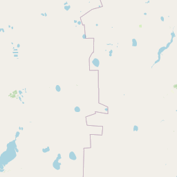
Map view of Koibagar-Tyntyugur Lakes

Use this park location map to pinpoint Koibagar-Tyntyugur Lakes in Kazakhstan, understand its exact geographic position, and read its mapped placement within the surrounding landscape more clearly.

Pigeon | © OpenStreetMap contributors

Location context for Koibagar-Tyntyugur Lakes

Kostanay RegionNorth Kazakhstan Region
Park atlas

Compare regional steppe reserves and adjacent northern Kazakhstan wetland habitats

Explore Protected Areas and Parks Near Koibagar-Tyntyugur Lakes

Browse adjacent protected landscapes and regional wetlands that share ecological traits with Koibagar-Tyntyugur Lakes. Comparing these northern Kazakhstan habitats reveals broader patterns in steppe hydrology and migratory waterbird conservation.
Watercolor illustration of a landscape with green hills, a body of water, and grassy foreground under a pink-hued sky
National parkAqmola Region
About 131 km away#1 closest

East

Kokshetau National Park: A Protected Granite Mountain and Forest-Steppe Landscape in Kazakhstan

Explore Aqmola Region's unique protected geography and mapped terrain.

Kokshetau National Park stands as a remarkable protected landscape within Kazakhstan, defined by its ancient granite mountains and its unique position as a forest-steppe island surrounded by open plains. This national park preserves a rich tapestry of boreal forests, lake-filled depressions, and geological wonders, including some of the planet's most ancient rock formations. MoriAtlas provides a structured view of Kokshetau National Park, detailing its mapped boundaries and geographic context within the Aqmola Region, offering users a deep dive into its protected area identity and ecological significance.

Area
1,821 km²
Established
1996
IUCN
II
Relief
Upland
Natural monumentNorth Kazakhstan Region
About 190 km away#2 closest

Northeast

Zhanazhol Pine Forest: Protected Natural Monument in North Kazakhstan Region

Mapped relict pine grove within the forest-steppe transition

Zhanazhol Pine Forest serves as a protected natural monument, preserving an isolated stand of mature Scots pine trees on sandy substrates. This site provides critical insights into the biogeography of the Ishim-Tobol interfluve, maintaining a distinct forest environment far from typical boreal ranges.

Area
0.09 km²
Relief
Lowland
Climate
Temperate
Access
Access unknown
Wildlife reserveAkmola Region
About 230 km away#3 closest

Southeast

Atbasar Wildlife Reserve: Protected Steppe Grasslands and Wildlife Habitat in the Akmola Region

Mapping conservation landscapes of northern Kazakhstan

Explore the geographic scope of Atbasar Wildlife Reserve, a significant sanctuary in northern Kazakhstan. This protected area preserves key steppe ecosystems and habitat for marmots and migratory birds within a unique terrain of rocky spurs and open feather grass plains.

Area
751 km²
Established
1976
IUCN
IV
Relief
Upland
Wildlife reserveKostanay Region
About 287 km away#4 closest

West

Mikhaylovsky Zakaznik: Geographic Overview of the Kostanay Region Wildlife Reserve

A protected forest steppe sanctuary in northern Kazakhstan.

Mikhaylovsky Zakaznik acts as an enduring zoological refuge within the Kostanay Region, protecting a rich tapestry of woodland and meadow steppe environments. This reserve supports native ungulates and game birds by maintaining a stable, low-profile landscape of birch and pine groves that function as critical corridors for biodiversity across the borderlands.

Area
768 km²
Established
1967
Relief
Upland
Access
Access unknown
Protected areaKostanay Region
About 294 km away#5 closest

Southwest

Taldykol Protected Area: Geographic Atlas and Wetland Landscape Analysis

A vital Ramsar-listed freshwater steppe habitat in Kostanay Region

Taldykol acts as a critical freshwater sanctuary within the dry climate of northern Kazakhstan. This protected area, defined by its central island and willow-fringed margins, forms an essential part of the Kulykol-Taldykol lake system. The basin provides a necessary stopover and breeding site for waterbirds, demonstrating how local water features define the ecological character of the surrounding Kostanay Region steppe terrain.

Area
10.5 km²
Relief
Lowland
Scope
Terrestrial
Water
Water-dominated
Watercolor painting of a landscape with green forests, hills, and a body of water
National parkAqmola Region
About 297 km away#6 closest

East

Burabay State National Nature Park: Mapped Granite Hills and Forested Terrain Atlas

Explore protected landscapes in Kazakhstan's Aqmola Region.

Burabay State National Nature Park presents a unique protected landscape within the Kokshetau Massif of Kazakhstan's Aqmola Region. This atlas-focused entry details the park's distinctive terrain, featuring ancient granite outcrops and rolling hills draped in pine and birch forests. Understand the mapped boundaries and geographic setting of this national park, renowned for its scenic lakes and significant geological formations, offering rich context for protected-area discovery.

Area
1,299.35 km²
Established
2000
IUCN
II
Relief
Mixed relief
Protected areaKostanay Region
About 301 km away#7 closest

Southwest

Kulykol Protected Area: Mapping the Shallow Steppe Wetlands of Northern Kazakhstan

Geography of the Kostanay Region saline lake systems

Trace the landscape of Kulykol, a sprawling shallow-water ecosystem situated in the Kamysty District. This protected wetland, defined by its saline chemistry and expansive reed-lined margins, represents a core element of the Kulykol-Taldykol lake system. The data provides a detailed look at the lake's basin topography, its intermittent connection to surrounding water bodies, and its status as a managed habitat within the open grasslands of the Tobil basin.

Area
33 km²
Established
2009
Relief
Lowland
Water
Water-dominated
Nature reserveKostanay Region
About 345 km away#8 closest

South

Altyn Dala Nature Reserve: Mapping Steppe Biodiversity and Migratory Corridors in Kazakhstan

A comprehensive look at the three-cluster protected landscape and regional geography

Spanning over 489,000 hectares, Altyn Dala Nature Reserve preserves diverse habitats ranging from the Sarykopa lake system to the vast Uly-Zhylyanshyk semi-desert steppe. This detail page tracks the reserve's unique cluster structure, geographic boundaries, and essential role in maintaining the historical integrity of northern Kazakhstan's grassland and river corridor ecosystems.

Area
4,897.66 km²
Established
2012
IUCN
VI
Relief
Lowland

Common questions about visiting, size, designation, and location context for Koibagar-Tyntyugur Lakes

Koibagar-Tyntyugur Lakes FAQs for park facts, access, geography, and protected area context

Find quick answers about Koibagar-Tyntyugur Lakes, including protected-area facts, park geography, trail and visitor context, and how the park fits into its surrounding country and regional landscape.
MoriAtlas Explorer

Continue Your Protected Areas Search Across the Global Atlas

Deepen your exploration by continuing the structured search for national parks and protected areas worldwide. Utilize the comprehensive filtering capabilities to compare different conservation landscapes and refine your understanding of global park geography. Discover more about the distribution and characteristics of protected natural areas.

Global natural geography