Mori Atlas logo
Protected areaKreideberg bei Ellerode

Understanding the ecological structure of this diverse calcareous beech forest reserve

Kreideberg bei Ellerode Protected Area: Mapped Geography and Natural Landscape Context

(Naturschutzgebiet Kreideberg bei Ellerode)

Kreideberg bei Ellerode serves as a compact, ecologically rich protected area located in the Werra-Meißner-Kreis of northern Hesse, Germany. This site features a distinct mosaic of old-growth beech forest, orchid-rich woodland communities, and rare calcareous spring marshes. Its geography, defined by lime-rich soils and rolling hill terrain, provides a vital habitat enclave situated between local agrarian land use and regional infrastructure corridors.

beech forestcalcareous forestNatura 2000nature reserveHesseWerra-Meißner-Kreis

Kreideberg bei Ellerode

Protected area

Park overview

Structured park overview, official facts, and landscape profile for Kreideberg bei Ellerode

Kreideberg bei Ellerode park facts, protected area profile, and essential visitor context

Review the core facts for Kreideberg bei Ellerode, including designation, size, terrain, visitor scale, habitats, and operating context in one park-focused overview.

About Kreideberg bei Ellerode

Kreideberg bei Ellerode is a compact nature reserve in northern Hesse, in the Werra-Meißner-Kreis near the town of Witzenhausen. Its location is geographically significant: it sits directly on the Hesse–Lower Saxony state border, between the Lower Saxon village of Atzenhausen to the north and the autobahn A7 to the south. The nearby Hessian village of Ellerode, which gives the site part of its name, lies just south of the motorway. The reserve covers roughly 57 hectares and is administered within the cadastral district (Gemarkung) of Berlepsch-Ellerode.

Although small in size, the site is ecologically dense. Its formal protection history began on 7 March 1995, when it was designated as a Naturschutzgebiet under Hessian nature conservation law. Because the protected perimeter matches an EU-level Natura 2000 site (FFH-Gebiet Nr4524-303), the area is also tied into the European Habitats Directive network, which strengthens its long-term conservation status.

Ecologically, the reserve is built around its calcareous geology, captured in the name Kreideberg (literally chalk hill). This substrate supports a near-natural, richly structured lime-beech forest with a high share of old trees. Two beech forest community types are prominent: the woodruff beech forest (Waldmeister-Buchenwald, around 32.8 ha) and the orchid beech forest (Orchideen-Buchenwald, around 6.3 ha). Between these woodland communities and surrounding agricultural land, there are narrow transitions of orchid-rich semi-dry grassland (about 0.2 ha) and traditional orchards (Streuobstwiesen), which add open-land habitats alongside the dominant forest matrix.

A further distinguishing feature is the presence of a well-preserved calcareous spring marsh (Kalkquellsumpf). This small wetland is ecologically valuable because calcareous seepage habitats of this type have become rare across much of central Germany. It supports Davall's sedge (Carex davalliana), a characteristic species of base-rich small-sedge communities, at what appears to be the northern edge of the species' range in this region.

The reserve is mostly in private ownership, with the responsible forestry office based in Hessisch Lichtenau and the higher nature conservation authority at the Regierungspräsidium Kassel. Management is guided by a 2014 measures plan developed under Hessian conservation law, indicating active, ongoing stewardship rather than passive designation only.

Quick facts and research context for Kreideberg bei Ellerode

Kreideberg bei Ellerode is a nature reserve (Naturschutzgebiet) in the Werra-Meißner-Kreis in northern Hesse, Germany, close to the border with Lower Saxony and south of the A7 motorway. The protected area covers about 57.1 hectares and is simultaneously designated as a Natura 2000 site (FFH area No. 4524-303).

The defining habitat is a near-natural, well-structured calcareous beech forest, with significant proportions of old-growth stands classified as woodruff beech forest and orchid beech forest. The reserve also includes orchid-rich semi-dry grassland fragments on the edge of farmland and orchards, plus a well-preserved lime-rich spring marsh (Kalkquellsumpf) that supports Davall's sedge at the northern edge of its range.

Protection and recognition

Examine terrestrial protection status and formal international recognition records.

Kreideberg bei Ellerode Protection Status and Natura 2000 Recognition

Documented protection status and Natura 2000 recognition details outline the territorial conservation framework for Kreideberg bei Ellerode. Structured designation records establish official administrative boundaries and international recognition sources without assuming management outcomes.

International recognition

Protection details

Protection scope
Terrestrial
Transboundary protection
No
Park context

Deeper park guide and search-rich context for Kreideberg bei Ellerode

Kreideberg bei Ellerode history, landscape, wildlife, and travel context

Explore Kreideberg bei Ellerode through its history, landscape character, ecosystems, wildlife, conservation priorities, cultural context, and seasonal travel timing in a structured park guide built for atlas discovery and search intent.

Why Kreideberg bei Ellerode stands out

The reserve is best known for its calcareous, old-growth beech forest on a chalk-influenced substrate, including some of the more orchid-rich woodland communities in northern Hesse. The combination of Waldmeister-Buchenwald, Orchideen-Buchenwald, small semi-dry grasslands, and a calcareous spring marsh makes it a compact but ecologically diverse site. Botanically, it is also notable as the northernmost occurrence of Davall's sedge (Carex davalliana) in the region, marking the species' range limit in this part of Central Europe.
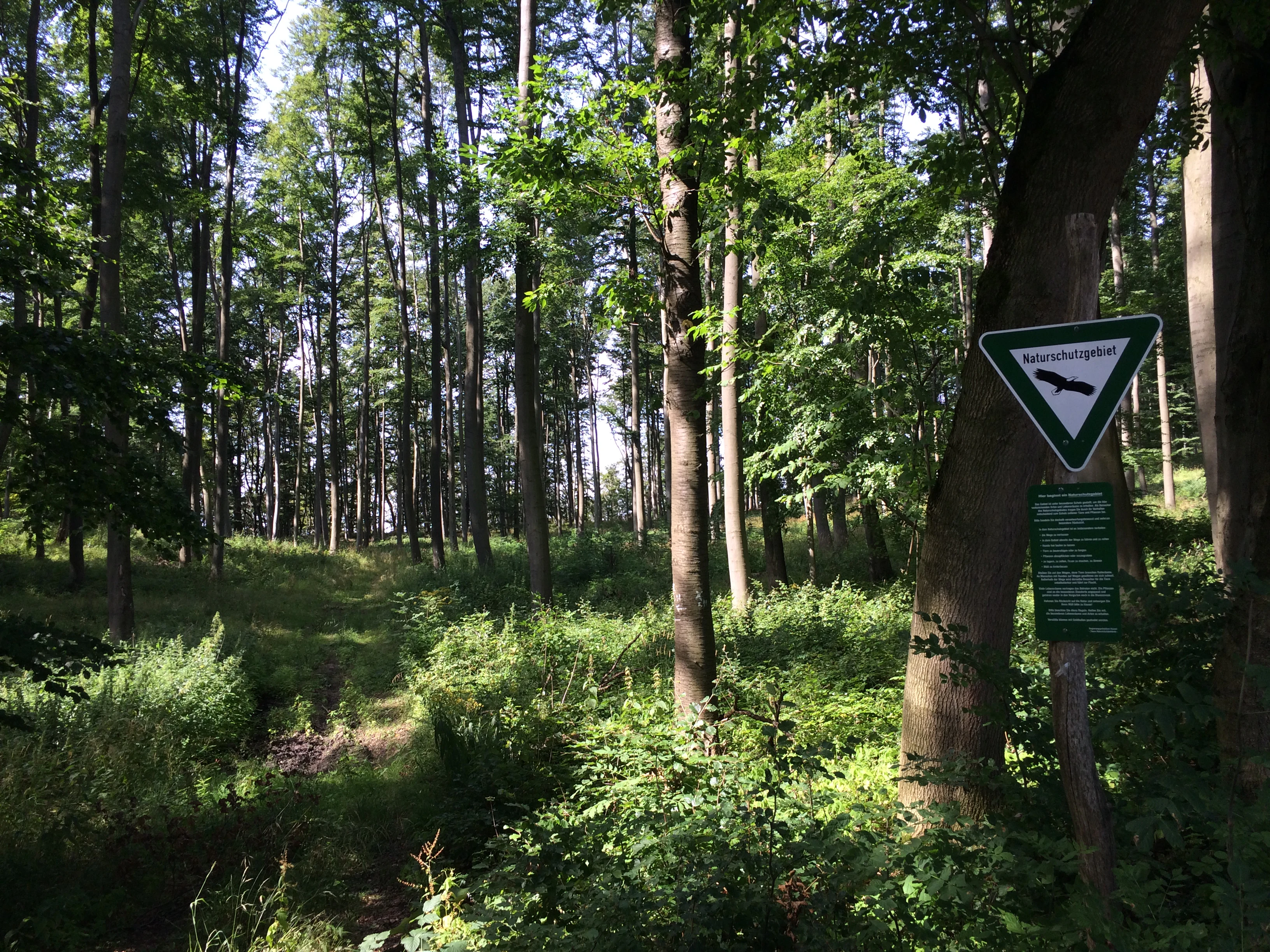
A dirt trail winds through a dense forest with tall trees and green undergrowth, marked by a triangular trail sign on a wooden post in the foreground.
A forest trail marked by a Werra-Burgen-Steig signpost among tall trees and green undergrowth.

Kreideberg bei Ellerode history and protected-area timeline

The area now known as Kreideberg bei Ellerode was formally designated as a Naturschutzgebiet on 7 March 1995, giving it long-term protection under Hessian nature conservation legislation. Its selection reflected its combination of old calcareous beech forest stands and small, ecologically valuable open habitats.

A second, parallel layer of protection came through its inclusion in the European Natura 2000 network as FFH-Gebiet Nr. 4524-303. The reserve's perimeter and size are identical between the German national designation and the European designation, integrating the site into the EU Habitats Directive framework.

Ongoing management is documented in a 2014 measures plan (Maßnahmenplan) issued by the Obere Naturschutzbehörde at the Regierungspräsidium Kassel. This plan, prepared under sections 5 and 15 of the Hessian Act on Nature Conservation and Biodiversity (HAGBNatschG), outlines concrete conservation actions and integrates the site into the broader FFH reporting and assessment cycle for Hesse.

Kreideberg bei Ellerode landscape and geographic character

The landscape of Kreideberg bei Ellerode is shaped by its calcareous, chalk-influenced substrate, reflected directly in the name Kreideberg ('chalk hill'). The result is a gently rolling, forested hill landscape typical of the northern edges of the Hessian low mountain foothills, where lime-rich soils emerge in a region otherwise characterized by mixed substrates. The terrain is dissected enough to support a mosaic of woodland stands, small clearings, seepage zones, and marginal grasslands, rather than a single uniform forest block.

Geographically, the site sits on the Hesse–Lower Saxony border and is tightly framed by human land use: the Lower Saxon village of Atzenhausen lies to the north, the village of Ellerode to the south, and the major A7 autobahn cuts past just south of the reserve. This surrounding land use creates sharp ecological contrasts at the reserve boundary, with forest meeting orchards, farmland, and transport infrastructure within a very short distance.

Kreideberg bei Ellerode ecosystems, habitats, and plant life

The reserve's ecological character is defined by calcareous beech forest on a lime-rich substrate. The dominant forest type is the woodruff beech forest (Waldmeister-Buchenwald, Galio odorati-Fagetum), a community typical of base-rich but mesic sites, which forms the bulk of the woodland. Embedded within it is a smaller but ecologically distinctive orchid beech forest (Orchideen-Buchenwald), a variant favoured by particularly calcareous conditions and known for its rich ground flora of orchids and other lime-demanding herbs.

Old-growth character is a key ecological signal: the high proportion of older trees, combined with structural diversity, supports deadwood habitats and a more layered vertical structure than typical managed forest. At the forest margin, narrow strips of orchid-rich semi-dry grassland (Halbtrockenrasen) create transitions to agricultural land and traditional Streuobstwiesen, preserving open-land elements that otherwise would be lost in a closed forest landscape.

The most ecologically distinctive micro-habitat is the calcareous spring marsh (Kalkquellsumpf), a small but well-preserved seepage area fed by base-rich groundwater. Such habitats have become increasingly fragmented across central Germany, and their presence here adds a wetland component to a reserve otherwise dominated by forest.

Kreideberg bei Ellerode wildlife and species highlights

Source documentation for Kreideberg bei Ellerode focuses primarily on vegetation, habitat types, and botanical rarities rather than on vertebrate fauna. The most prominent wildlife-relevant signal in the available material is the occurrence of Davall's sedge (Carex davalliana) in the calcareous spring marsh, where the species reaches the northern edge of its distribution range. The orchid-rich beech forest and semi-dry grassland also suggest habitat value for invertebrates associated with old woodland and calcareous grassland, but specific faunal information is not detailed in the source.

Kreideberg bei Ellerode conservation status and protection priorities

Kreideberg bei Ellerode is protected both at the national level as a Naturschutzgebiet under Hessian law (designated 7 March 1995) and at the European level as a Natura 2000 site (FFH-Gebiet Nr4524-303). The dual designation gives the reserve a layered legal framework: national protection for its overall habitats, and EU-level protection tied to the Habitats Directive and to specific feature-based reporting obligations.

Its conservation value derives from the combination of old-growth calcareous beech forest, the smaller but botanically significant orchid beech forest component, and the calcareous spring marsh with Davall's sedge at its range limit. These features make the site disproportionately important relative to its size for maintaining lime-dependent forest and wetland communities in northern Hesse.

Management is documented in a 2014 Maßnahmenplan issued by the Obere Naturschutzbehörde at the Regierungspräsidium Kassel, prepared under § 5 and § 15 of the Hessian Act on Nature Conservation and Biodiversity. This active plan-based management, rather than purely passive protection, positions the reserve within Hesse's broader FFH monitoring and stewardship cycle.

Kreideberg bei Ellerode cultural meaning and human context

The surrounding cultural landscape is shaped by small villages and traditional agricultural use. Ellerode, which gives the reserve part of its name, is a small Hessian village directly south of the A7 motorway, while Atzenhausen lies just to the north in Lower Saxony. The presence of Streuobstwiesen (traditional orchards) and small semi-dry grassland patches at the reserve margin reflects the older Central European pattern of land use, in which woodlands, orchards, and small-scale farming met at sharp boundaries. This pattern is itself a cultural-historical feature of the Werra-Meißner region as much as an ecological one.

Top sights and standout views in Kreideberg bei Ellerode

Kreideberg bei Ellerode is a compact but unusually diverse calcareous beech forest reserve, notable for combining old-growth woodland structure, a rare orchid beech forest community, and a small but ecologically important calcareous spring marsh on a single site. Its dual national and Natura 2000 status places the small reserve within both Hessian and European conservation frameworks. The presence of Davall's sedge at its northern range limit gives the site a botanical significance that extends well beyond the Werra-Meißner-Kreis.

Best time to visit Kreideberg bei Ellerode

The reserve is most rewarding to experience in late spring and early summer, when the understorey of the beech forest is at its richest and orchids in both the woodland and the small semi-dry grassland fringes are most likely to be visible. Spring is also the most active period for the calcareous spring marsh flora. Late summer and autumn highlight the structural character of the old beech stands and their developing mast, but the botanical colour of the herb layer diminishes. Because the site is a designated nature reserve with primarily private land status, visits are best approached as quiet, low-impact observation rather than as a developed visitor destination.

Monthly climate preview

Track monthly precipitation rhythms and average temperatures at a representative coordinate.

Kreideberg bei Ellerode Climate and Long-Term Temperature Normals

Representative records from 1991 to 2000 outline the measured annual temperature and precipitation rhythm across Kreideberg bei Ellerode. Examining the complete monthly data profile provides deeper insight into long-term climate normals.
Annual mean8 °C
-1 °C18 °C
Jan-1°
Feb
Mar
Apr
May12°
Jun16°
Jul18°
Aug18°
Sep14°
Oct
Nov
Dec
Warmest month
July

18.2 °C

Coolest month
January

-0.9 °C

Wettest month
July

2.6 mm/day

Driest month
April

1.5 mm/day

Park location guide

Geography guide, regional context, and park location map for Kreideberg bei Ellerode

Kreideberg bei Ellerode park geography, regions, and map view in Germany

Understand where Kreideberg bei Ellerode sits in Germany through a broader geographic reading of the surrounding landscape, nearby location context, and its mapped position within the national park landscape.

How Kreideberg bei Ellerode fits into Germany

Germany is a federal republic in Western and Central Europe with a population of over 83 million across sixteen constituent states. It is Europe's largest economy by nominal GDP and a major global exporter and importer. The capital is Berlin, and the country borders Denmark, Poland, Czech Republic, Austria, Switzerland, France, Luxembourg, Belgium, and the Netherlands.

Wider geography shaping Kreideberg bei Ellerode in Germany

Germany is located in Western and Central Europe, spanning 357,022 km². It borders Denmark to the north, Poland and the Czech Republic to the east, Austria and Switzerland to the south, and France, Luxembourg, Belgium, and the Netherlands to the west. The country has coastlines on the Baltic Sea and North Sea to the north, with the Alps located in the southern region.

Map view of Kreideberg bei Ellerode

Use this park location map to pinpoint Kreideberg bei Ellerode in Germany, understand its exact geographic position, and read its mapped placement within the surrounding landscape more clearly.

Pigeon | © OpenStreetMap contributors
Recorded earthquake history

Explore the Historical Seismic Catalogue for Kreideberg bei Ellerode

Access a structured collection of historical earthquake records for the area surrounding Kreideberg bei Ellerode. This MoriAtlas dataset allows you to examine recorded seismic events, including their proximity to the reserve, magnitude, and date of occurrence, providing a clear geographic view of regional seismic history.

Kreideberg bei Ellerode Earthquake History

Catalogued events

2 events

Strongest magnitude

Magnitude 3.1

Most recent event

Mar 30, 1995

This history includes earthquakes recorded inside the park or within 50 km of its borders

Visualizing the calcareous beech forests, chalk hills, and habitats of northern Hesse

Kreideberg bei Ellerode Photos and Landscape Scenery

Visual documentation reveals the rolling terrain, old-growth beech stands, and chalk-influenced habitats that define the protected landscape. Examining these photographs provides clearer insight into the botanical diversity and forest structure preserved within the reserve.

A dirt trail winds through a dense forest with tall trees and green undergrowth, marked by a triangular trail sign on a wooden post in the foreground.

Park atlas

Compare surrounding regional beech forests and chalk-influenced nature reserves

Discover Parks Near Kreideberg bei Ellerode and Related Protected Landscapes

Browse other protected areas near Kreideberg bei Ellerode to examine neighboring calcareous woodland reserves and regional forest ecosystems. Continuing into surrounding park geography reveals broader botanical patterns across the Hessian low mountain foothills.
A minimalist watercolor painting featuring soft green trees and rolling hills in the background against a light, airy white backdrop.
Nature reserveWerra-Meißner-Kreis
4 km away#1 closest

South

Ermschwerder Heegen Nature Reserve: Muschelkalk Ridge and Floodplain Geography

Protected mosaic of forests, marshes, and meadows in northern Hesse

Ermschwerder Heegen preserves a compact but ecologically significant landscape in the Werra-Meißner-Kreis. Its unique topography features a limestone ridge dropping into the Werra valley, supporting a rich mixture of forest, orchard, and wetland habitats that rank among the most important in the region for biodiversity.

Area
0.37 km²
Established
1985
IUCN
IV
A horizontal watercolor painting showing a winding river flowing through a lush valley with forested hills in the background.
Protected areaHesse
4.4 km away#2 closest

South

Freudenthal bei Witzenhausen Protected Landscape and Wetland Geography in Hesse

A restored gravel pit wetland system in the northern Hesse Werra valley.

Freudenthal bei Witzenhausen represents a high-value conservation landscape within Hesse, serving as a primary site for breeding and migratory waterbirds. The reserve comprises three interconnected quarry lakes surrounded by alluvial woodland, ruderal vegetation, and meadows. This habitat mosaic is part of the Natura 2000 network, providing essential ecological connectivity within the riverine corridor of the lower Werra valley.

Area
0.76 km²
Established
1980
Relief
Lowland
Climate
Temperate
A horizontal watercolor illustration depicting rolling green hills, scattered trees, and soft mountain silhouettes against a pale sky.
Protected areaGermany
7.8 km away#3 closest

South

Kalkmagerrasen bei Roßbach: Protected Calcareous Grassland and Juniper Landscape in Germany

Geographic atlas and protected area overview in Hesse

Kalkmagerrasen bei Roßbach consists of five distinct plots that protect rare Enzian Schillergras Rasen communities on shallow Zechstein limestone soils. This site remains a critical stronghold for diverse orchid populations and protected butterfly species within the Werra Meißner region. The mosaic of juniper, flowering herbs, and historic cherry orchards creates a unique Mediterranean character rarely found in central German hill country.

Area
0.551 km²
Established
1996
Relief
Upland
Climate
Temperate
A horizontal watercolor painting depicting a soft, atmospheric landscape with rolling green hills, a winding river or water feature, and distant pale mountains under a hazy, pastel sky.
Protected landscapeLower Saxony
About 9.9 km away#4 closest

West

Naturpark Münden Protected Landscape: Geography and Regional Mapping in Lower Saxony

Forested ridges and river valleys in southern Germany

Naturpark Münden offers a detailed look at the central German low mountain range. Discover the mapping of the Kaufunger Wald and Bramwald, the significance of the Fulda and Werra river confluences, and the structure of this historically significant protected landscape located in Lower Saxony.

Area
374 km²
Established
1959
Relief
Mountain
Water
Major water bodies
Watercolor painting of a pastoral landscape with light green hills in the distance, a field with flowering pink trees, and a pale green meadow in the foreground.
Nature reserveWerra-Meißner-Kreis
9.9 km away#5 closest

Southeast

Ebenhöhe-Liebenberg Nature Reserve: Geography and Protected Habitat Mapping

Protected calcareous forests and dry grassland mosaic

Explore the mapped boundaries and natural terrain of the Ebenhöhe-Liebenberg nature reserve. This site provides a critical habitat mosaic including orchid-rich beech woodlands, nutrient-poor grasslands, and sandstone outcrops that form a significant conservation area within the Hessian highlands.

Area
142.48 km²
Established
1995
IUCN
IV
Relief
Upland
A soft watercolor illustration depicting a winding river landscape with lush trees and rolling hills in the background.
Nature reserveLandkreis Eichsfeld
About 14 km away#6 closest

Southeast

Kelle, Teufelskanzel Nature Reserve: Geographic Overview and Protected Area Atlas

Steep slopes and sandstone ridges in Landkreis Eichsfeld

Situated along the Höheberg ridge in Thuringia, Kelle, Teufelskanzel represents a vital 200 hectare nature reserve. Its geography is defined by deep V-shaped valleys, dramatic rock outcrops like the Teufelskanzel, and a dense mix of deciduous forests that form part of the historic Inner German Border conservation zone.

Area
2.002 km²
Established
1996
IUCN
IV
Relief
Mountain
A horizontal watercolor illustration depicting gentle rolling hills, grassy meadows, and distant mountain silhouettes in muted pastel tones.
Nature reserveThuringia
15 km away#7 closest

Southeast

Röhrsberg - Hasenwinkel - Mühlberg: Mapping the Protected Landscapes of Thuringia

Geological ridge systems and native forest habitat networks.

The Röhrsberg - Hasenwinkel - Mühlberg nature reserve represents a significant protected area in Thuringia, characterized by the juxtaposition of Muschelkalk limestone hills and Zechstein dolomite ridges. This site offers a concentrated view of regional terrain, shifting from closed beech forests to open juniper heaths. It serves as an essential geographic reference for understanding the ecological mosaic of the lower Werra hill country.

Area
4.51 km²
Established
1999
IUCN
IV
Relief
Upland
Watercolor painting of a soft landscape featuring green trees and rolling hills in muted tones against a white background.
Nature reserveGermany
About 15 km away#8 closest

West

Bruchwald am Gahrenberg Nature Reserve: A Protected Wetland Atlas of the Reinhardswald

Mapped terrain, bog woodland, and hydrological headwaters in Hessen

Located in the Reinhardswald forest massif, Bruchwald am Gahrenberg protects critical marsh and bog woodland habitats. The area serves as a primary source for regional streams, offering a dense, spring-fed landscape that stands out within the broader northern German wilderness.

Area
0.41 km²
Established
1992
Relief
Upland
Climate
Temperate

Common questions about visiting, size, designation, and location context for Kreideberg bei Ellerode

Kreideberg bei Ellerode FAQs for park facts, access, geography, and protected area context

Find quick answers about Kreideberg bei Ellerode, including protected-area facts, park geography, trail and visitor context, and how the park fits into its surrounding country and regional landscape.
MoriAtlas Explorer

Continue Your Protected Areas Search Across the Global Atlas

Deepen your exploration by continuing the structured search for national parks and protected areas worldwide. Utilize the comprehensive filtering capabilities to compare different conservation landscapes and refine your understanding of global park geography. Discover more about the distribution and characteristics of protected natural areas.

Global natural geography