Mori Atlas logo
Nature reserveKuhgrabensee

A groundwater-fed lake and habitat mosaic within the regional topography of Blockland

Kuhgrabensee Nature Reserve: Mapped Protected Landscapes and Geography in Bremen, Germany

(Naturschutzgebiet Kuhgrabensee)

Kuhgrabensee represents a significant protected area in Bremen, where a former quarrying pit has been transformed into a thriving nature reserve and recognized EU Bird Protection Area. This site showcases an intricate mosaic of open water, reed fringes, and engineered shallow-water zones that support a variety of dragonflies, amphibians, and breeding waterbirds. Through its unique saline-influenced groundwater chemistry, the reserve offers a distinctive study of inland aquatic ecosystems within the wider agricultural plains of the region.

lakenature reservequarrying lakegroundwater-fed lakebrackish influencebird protection area

Kuhgrabensee

Nature reserve

Park overview

Structured park overview, official facts, and landscape profile for Kuhgrabensee

Kuhgrabensee park facts, protected area profile, and essential visitor context

Review the core facts for Kuhgrabensee, including designation, size, terrain, visitor scale, habitats, and operating context in one park-focused overview.

About Kuhgrabensee

Kuhgrabensee occupies a distinctive niche within Bremen's network of protected areas. Although it began its existence as a by-product of large-scale infrastructure construction rather than as a planned ecological site, decades of restoration, legal protection, and ecological engineering have turned it into one of the more ecologically interesting small waterbodies in the city-state.

The lake lies at the southeastern edge of Bremen's Blockland district, close to the traditional boundary with the neighboring Hollerland area. This boundary is marked by the Kuhgraben ditch, the watercourse that gives the lake its name. The lake is read most naturally as part of Bremen's wider wetland countryside to the west and north of the city, where surviving fragments of fen, marsh, and grazing land still shape the landscape between suburban Bremen and the surrounding Lower Saxon countryside.

Geologically, the lake's character is shaped by an unusual underground influence. The groundwater that feeds Kuhgrabensee interacts with the Lilienthal salt dome, a geological saline formation that lies below the broader Bremen area. As a result, the lake's water carries noticeably higher salt content than is typical for inland Bremen waterbodies. This brackish influence, along with the lake's mesotrophic status, makes the chemical environment relatively unusual and supports plant species that would not thrive in purely freshwater systems. Expanding the lake in 1998–1999 by adding a roughly 4 hectare shallow-water zone was a deliberate ecological compensation measure, widening the range of water depths and therefore the range of habitats available around the shoreline.

Today Kuhgrabensee is appreciated primarily as a quiet local nature site rather than as a tourist destination in the traditional sense. It can be viewed from the Kuhgrabenweg and the Mittelweg, and a small observation hut offers a point of contact for visitors. The lake's combination of inland location, mineral-rich groundwater, protected status as a nature reserve since 1987, and recognition as a European Bird Protection Area means that it carries ecological weight well beyond its modest surface area within the city of Bremen.

Quick facts and research context for Kuhgrabensee

Kuhgrabensee is a lake of roughly 17.8 hectares in southeast Bremen, lying at the traditional boundary between the Blockland and Hollerland districts along the Kuhgraben watercourse. It was excavated 1970–1972 during construction of the A27 motorway and is therefore classified as a Baggersee, or quarrying lake. Since 1987 its 29.6 hectare shore zone has been designated as a nature reserve (Naturschutzgebiet), and in 1998–1999 an approximately 4 hectare shallow-water zone was added as an ecological compensation measure. The lake is groundwater-fed and shows elevated salinity due to the influence of the Lilienthal salt dome, with mesotrophic water quality. The site is registered as a European Bird Protection Area, supporting breeding waterbirds and a notable community of aquatic plants, dragonflies, and amphibians.

Protection and recognition

Documented terrestrial protection scope and international recognition records

Kuhgrabensee Protection Status and Natura 2000 Recognition Data

Terrestrial protection records for Kuhgrabensee outline the designated conservation scope and official Natura 2000 recognition sources. Reviewing these documented protection metrics provides clear insight into the official governance framework assigned to the protected area.

International recognition

Protection details

Protection scope
Terrestrial
Transboundary protection
No
Park context

Deeper park guide and search-rich context for Kuhgrabensee

Kuhgrabensee history, landscape, wildlife, and travel context

Explore Kuhgrabensee through its history, landscape character, ecosystems, wildlife, conservation priorities, cultural context, and seasonal travel timing in a structured park guide built for atlas discovery and search intent.

Why Kuhgrabensee stands out

Kuhgrabensee is best known as a protected former quarrying lake in Bremen whose saline-influenced, groundwater-fed waters have allowed a distinctive mosaic of pioneer plants, dragonflies, amphibians, and breeding waterbirds to develop. Its designation as an EU Bird Protection Area and its combination of open water, reed fringe, and engineered shallow-water zones give it an outsized ecological relevance relative to its modest size.
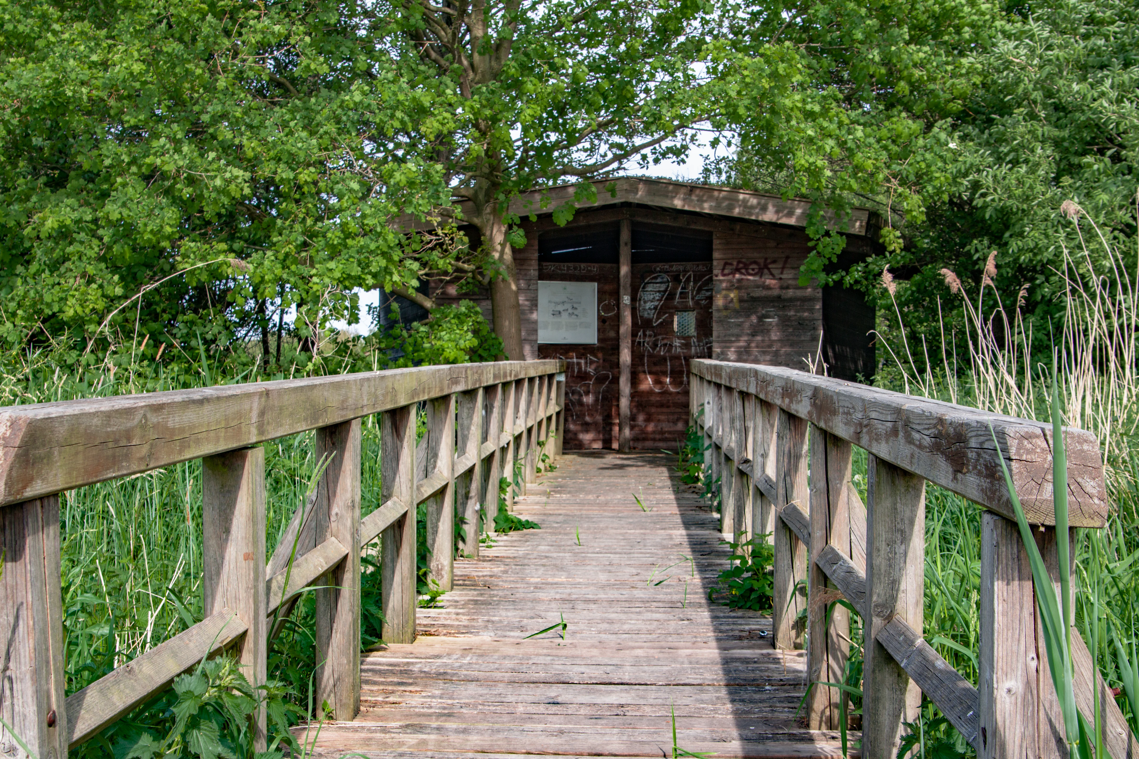
A wooden footbridge leads through green reeds to a small, weathered wooden observation structure surrounded by trees.
A wooden footbridge leading to a bird observation shelter at the Kuhgrabensee nature reserve.

Kuhgrabensee history and protected-area timeline

Kuhgrabensee is a relatively young waterbody in geological terms, with its entire history tied to modern infrastructure and environmental policy in Bremen. Between 1970 and 1972 the basin was excavated as part of the construction of the Bundesautobahn 27, the motorway that links Bremen to the south. The resulting pit filled with groundwater and became the Baggersee that exists today, a utilitarian origin that shaped both its relatively regular form and its inland location near the Blockland-Hollerland boundary marked by the Kuhgraben.

In the years that followed, the new lake began to acquire ecological value, and in July 1987 the waterbody and its surrounding shoreline were formally designated as a nature reserve, encompassing roughly 29.6 hectares. This designation marked a transition from a working quarrying site to a legally protected natural area, and from this point the lake's management shifted toward ecological rather than extractive priorities.

A second major chapter in the lake's history came in 1998–1999, when the site was expanded by approximately 4 hectares of shallow-water habitat as part of an ecological compensation measure. This enlargement broadened the range of water depths and shoreline conditions around the lake. Later recognition at the European level as a Vogelschutzgebiet (Bird Protection Area under the EU Birds Directive) cemented Kuhgrabensee's status as a regionally small but ecologically meaningful protected site within the Free Hanseatic City of Bremen.

Kuhgrabensee landscape and geographic character

The landscape of Kuhgrabensee is dominated by the lake itself, a roughly seventeen-hectare sheet of open water with a maximum depth of about 16 meters and an average depth of around 13 meters. Its relatively regular, deep basin reflects its origin as a quarried pit rather than as a natural depression, and there are no steep mountain or coastal landforms associated with the site; the lake sits low within the flat north German countryside that characterizes the Bremen region.

The lake is framed by a mix of shoreline types. Older, deeper banks give way to younger, deliberately engineered shallow zones added in 1998–1999, which now form broad, gently shelving margins of warm, sun-exposed water. These shallow margins are paired with reed fringes and damp vegetated banks that grade into the wider agricultural and pasture landscape of the surrounding Blockland area. The whole setting is softened by low horizon lines typical of the Weser region, where waterbodies are typically set within open meadows and grazing fields rather than within forested terrain.

To the east of the lake runs the Kuhgraben, an older ditch that gives the site its name and that traditionally marks the boundary between the Blockland and Hollerland districts. This combination of open water, constructed shallows, reed edge, ditch corridor, and surrounding farmland defines the local landscape character and supports much of the site's ecological value.

Kuhgrabensee ecosystems, habitats, and plant life

The nature of Kuhgrabensee is shaped by the unusual combination of groundwater feeding, saline influence from the nearby Lilienthal salt dome, mesotrophic water quality, and a varied shoreline that includes both older deeper margins and newer shallow-water zones. Together these conditions support a habitat mosaic that is unusual for a small inland Bremen waterbody. The lake functions as both a freshwater and a mildly brackish ecological environment, which broadens the range of plant and animal communities it can host.

Pioneer plant communities play a particularly important role at the site. Where freshly disturbed sediments and newly flooded shallow zones are exposed, characteristic early-succession species establish themselves. Armleuchteralgen (stoneworts) and Laichkräuter (pondweeds) occur in the submerged aquatic vegetation, while more specialised species such as Wasserpfeffer-Tännel and the threatened Nadel-Sumpfsimse (a rare bulrush) have been recorded around the lake.

The dragonfly fauna of the lake is also notable, with the mix of open water, shallow margins, and emergent vegetation providing habitat for a diverse community of these insects. Amphibians similarly benefit from the combination of standing water, warm shallow zones, and undisturbed banks. Taken together, the lake's ecological profile is that of a nutrient-moderate, mineral-influenced waterbody whose engineered shallows have significantly enriched its habitat value over time.

Kuhgrabensee wildlife and species highlights

The wildlife profile of Kuhgrabensee is most strongly defined by its birdlife, which is the reason the lake is recognised as a European Bird Protection Area. The combination of open water, sheltered reed bays, and shallow feeding zones provides breeding, resting, and foraging habitat for a variety of waterbirds, and the lake is documented as a breeding area for species such as the Haubentaucher, the Great Crested Grebe, which nests among the emergent vegetation along the margins.

Beyond its breeding birds, the lake's ecological value extends to invertebrates and amphibians. Dragonflies are particularly prominent, using both the open water and the warmer, shallower margins added during the 1998–1999 expansion. Amphibians are also part of the regular fauna of the site, drawn to the quiet shoreline conditions and to the structural variety of banks and shallows around the lake.

Because Kuhgrabensee is a relatively small and ecologically managed site embedded in agricultural land, its wildlife value lies less in large mammal populations and more in the seasonal and breeding presence of waterbirds, in the invertebrate communities of the water and shore, and in the amphibians that depend on undisturbed shallow water and banks.

Kuhgrabensee conservation status and protection priorities

Kuhgrabensee has a layered conservation status that reflects both German and European protection frameworks. At the national and state level, the lake and its roughly 29.6 hectare shore zone have been formally designated as a Naturschutzgebiet, a nature reserve under German nature conservation law, since July 1987. This designation establishes the lake as a legally protected area whose management must prioritize ecological values.

At the European level, the site is registered as a europäisches Vogelschutzgebiet, a Special Protection Area for birds under the European Union Birds Directive. This recognition reflects the lake's importance for breeding, migrating, and wintering waterbirds and binds the site into the wider Natura 2000 network of protected areas across Europe.

From a conservation perspective, the lake's value rests on several interacting features: its groundwater-fed and mildly saline chemistry, its mesotrophic water quality, the mosaic of deeper and shallower shore habitats created in part by the 1998–1999 ecological compensation work, and the populations of pioneer plants, dragonflies, amphibians, and breeding waterbirds that depend on these conditions. The combination of reserve status, Bird Protection Area designation, and engineered habitat expansion means that the conservation significance of this small Bremen lake extends well beyond its immediate surroundings.

Top sights and standout views in Kuhgrabensee

Kuhgrabensee stands out as a striking example of how infrastructure-related quarrying lakes can be transformed into ecologically valuable protected areas. The 1998–1999 shallow-water expansion is a particularly notable highlight, because it shows deliberate ecological engineering converting a formerly uniform pit into a habitat mosaic that supports rare plants, amphibians, dragonflies, and breeding waterbirds. Combined with the lake's dual designation as both a German nature reserve and a European Bird Protection Area, this makes Kuhgrabensee one of the more ecologically dense protected sites within the Free Hanseatic City of Bremen.

Best time to visit Kuhgrabensee

Kuhgrabensee is at its most rewarding from late spring through early summer, when breeding waterbirds such as the Great Crested Grebe are active around the margins and when dragonflies and amphibians are most visible along the shallow-water zones. Late summer also offers good conditions for observing mature aquatic vegetation along the engineered shallows. Winters can bring additional waterbird presence, though the flat, open character of the site means that cold-season visits are more about quiet observation than about dramatic seasonal scenery, and the lake's trail access from the Kuhgrabenweg and Mittelweg makes any mild-weather period suitable for a calm visit.


Monthly climate preview

Measured monthly precipitation and average temperature profiles for Bremen

Kuhgrabensee Climate Normals and Long Term Temperature Rhythms

Long term climate data for Kuhgrabensee outlines a measured annual rhythm ranging from winter subzero minimums to summer maximums near twenty nine degrees Celsius alongside steady daily precipitation. Detailed monthly records provide complete baseline weather patterns across the representative coordinate.
Annual mean9 °C
1 °C18 °C
Jan
Feb
Mar
Apr
May13°
Jun16°
Jul18°
Aug18°
Sep14°
Oct10°
Nov
Dec
Warmest month
July

18 °C

Coolest month
January

1 °C

Wettest month
July

2.5 mm/day

Driest month
April

1.4 mm/day

Park location guide

Geography guide, regional context, and park location map for Kuhgrabensee

Kuhgrabensee park geography, regions, and map view in Germany

Understand where Kuhgrabensee sits in Germany through a broader geographic reading of the surrounding landscape, nearby location context, and its mapped position within the national park landscape.

How Kuhgrabensee fits into Germany

Germany is a federal republic in Western and Central Europe with a population of over 83 million across sixteen constituent states. It is Europe's largest economy by nominal GDP and a major global exporter and importer. The capital is Berlin, and the country borders Denmark, Poland, Czech Republic, Austria, Switzerland, France, Luxembourg, Belgium, and the Netherlands.

Wider geography shaping Kuhgrabensee in Germany

Germany is located in Western and Central Europe, spanning 357,022 km². It borders Denmark to the north, Poland and the Czech Republic to the east, Austria and Switzerland to the south, and France, Luxembourg, Belgium, and the Netherlands to the west. The country has coastlines on the Baltic Sea and North Sea to the north, with the Alps located in the southern region.

Map view of Kuhgrabensee

Use this park location map to pinpoint Kuhgrabensee in Germany, understand its exact geographic position, and read its mapped placement within the surrounding landscape more clearly.

Pigeon | © OpenStreetMap contributors

Location context for Kuhgrabensee

Bremen
Recorded earthquake history

Examine Recorded Earthquake History Near the Kuhgrabensee Nature Reserve

Access a detailed catalogue of historical seismic events associated with the location of Kuhgrabensee. Review event documentation and geographical data points to understand the seismic history recorded within the wider Bremen region surrounding this nature reserve.

Kuhgrabensee Earthquake History

Catalogued events

3 events

Strongest magnitude

Magnitude 4.5

Most recent event

Jul 15, 2005

This history includes earthquakes recorded inside the park or within 50 km of its borders

Explore detailed imagery of open water, reed fringes, and engineered wetland habitats.

Kuhgrabensee Photos and Landscape Scenery: Visualizing the Protected Nature Reserve

Visual documentation captures the flat pasture horizons, shallow shorelines, and brackish aquatic environments defining the protected reserve. Reviewing these field photographs reveals the distinctive ecological layout of the former quarry lake and its surrounding wetland zones.

A wooden footbridge leads through green reeds to a small, weathered wooden observation structure surrounded by trees.

A serene lake surrounded by a dense forest under a clear sky, with reflections visible on the water surface.

Park atlas

Compare regional wetland habitats and nearby protected areas across northwestern Germany

Explore Parks Near Kuhgrabensee and Surrounding Protected Landscapes

Continue exploring regional protected areas and wetland reserves connected to the broader Bremen landscape. Comparing nearby natural sites provides valuable geographic context for understanding local habitat networks.
A soft, painterly watercolor illustration depicting a winding river through a flat green meadow with rolling hills in the background.
Nature reserveBremen
0 km away#1 closest

East

Hollerland Nature Reserve: A Protected Cultural Landscape and Wetland in Bremen

Historic marshland terrain with unique saline spring ecosystems

Hollerland is a 293-hectare nature reserve in Bremen, Germany, notable for its well-preserved cultural landscape of wet grasslands and an intricate medieval ditch network. This protected area serves as a critical breeding ground for meadow birds and hosts an ecologically significant inland saline spring, providing a rare habitat for brackish-adapted plant communities deep within the regional landscape.

Area
2.93 km²
Established
1985
IUCN
IV
Relief
Lowland
A watercolor painting showing a serene landscape with calm water, small islands of trees, and rolling hills in the background.
Nature reserveBremen
About 0.4 km away#2 closest

Southwest

Am Stadtwaldsee (Uni-Wildnis) Nature Reserve: Geographic Atlas and Park Map Context

Protected secondary habitat landscape in Bremen, Germany

Located in Bremen, the Am Stadtwaldsee (Uni-Wildnis) nature reserve offers a compelling study of secondary ecological succession. The area features a dense concentration of ponds and wooded ground shaped by historical sand mining. Explore the mapped boundaries of this eleven-hectare refuge to understand its role in urban biodiversity and regional landscape conservation.

Area
0.114 km²
Established
1991
IUCN
IV
Nature reserveBremen
1.4 km away#3 closest

North

Untere Wümme Nature Reserve: Riverine Biodiversity and Protected Tidal Landscapes in Bremen

Protected floodplain geography and tidal river habitats.

This nature reserve protects the meandering lower course of the Wümme river, showcasing one of northern Germany's few freshwater tidal systems. Spanning reedbeds, willow forests, and open mudflats, the reserve forms a vital corridor for migratory fish and waterfowl, reflecting a complex mosaic of protected riverine ecosystems and historic meadow landscapes.

Area
1.485 km²
Established
1991
Relief
Lowland
Climate
Temperate
A pale, soft-toned watercolor illustration of a calm river meandering through open, green marshy meadows with distant rolling hills under a soft pink sky.
Nature reserveBremen
3.3 km away#4 closest

East

Borgfelder Wümmewiesen: Protected Wetland and Floodplain Geography in Bremen

An expansive 688-hectare nature reserve with river-fed grasslands.

Borgfelder Wümmewiesen offers a look at one of the largest protected nature reserves in the Bremen region. The landscape is characterized by its flat, open terrain and regular water dynamics that frame a rich mosaic of wet meadows, reedbeds, and ponds, providing essential habitat for breeding and migratory bird species along the Wümme river corridor.

Area
6.88 km²
Established
1987
Relief
Lowland
Climate
Temperate
A watercolor painting showing a soft, panoramic view of a flat wetland area with green trees, a solitary tree in the middle, and industrial silos faintly visible in the background.
Nature reserveBremen
About 7.5 km away#5 closest

West

Hochwasserschutzpolder zwischen Senator-Apelt-Straße und Neustädter Hafen: Bremen Protected Lands

A vital wetland reserve integrating flood management and avian biodiversity in the port district.

Located within the port district of Bremen, the Hochwasserschutzpolder zwischen Senator-Apelt-Straße und Neustädter Hafen is a notable protected area that balances essential flood-control infrastructure with rich ecological functions. The reserve sustains a variety of wetland bird populations across its reed-lined waters and alluvial woodlands, providing a critical haven for wildlife amidst the surrounding industrial and urban development of the Lower Weser region.

Area
0.847 km²
Established
2014
IUCN
IV
Nature reserveBremen
About 8.1 km away#6 closest

South

Vogelschutzgebiet Arsten-Habenhausen: Mapping the Protected Weser Floodplain Habitat

A historic urban nature reserve located in Bremen

Located in the Habenhausen district of Bremen, Vogelschutzgebiet Arsten-Habenhausen is a significant protected area focused on river floodplain maintenance. The site provides a concentrated view of floodplain woodland and reedbed vegetation, illustrating how small, long-established nature reserves contribute to the regional geography of the Weser river corridor in Germany.

Area
0.01 km²
Established
1950
IUCN
IV
Relief
Lowland
A horizontal watercolor painting showing a tranquil lake scene with green trees, low-lying hills in the distance, and grassy banks against a white background.
Nature reserveBremen
8.2 km away#7 closest

Northwest

Grambker Feldmarksee Nature Reserve: Mapping the Protected Landscapes of Bremen

A vital wetland sanctuary shaped by regional infrastructure and natural restoration

Grambker Feldmarksee offers a focused look at how post-industrial quarry sites evolve into ecologically dense nature reserves. This groundwater-fed lake in Bremen acts as a green island, showcasing mature woodland fringes and specialized wetland habitats that are integral to the local bird protection network.

Area
0.226 km²
Established
2009
Relief
Lowland
Climate
Temperate
Nature reserveLandkreis Osterholz
About 8.2 km away#8 closest

Northeast

Westliche Hälfte des Langen Moores Nature Reserve in Landkreis Osterholz

A protected mosaic of highmoor peatland geography

Examine the distinct ecological features of Westliche Hälfte des Langen Moores, a protected nature reserve in Landkreis Osterholz. This site offers a compact look at highmoor regeneration and the diverse plant communities found within the historic Teufelsmoor cultural landscape of northern Germany.

Area
0.11 km²
Established
1984
IUCN
IV

Common questions about visiting, size, designation, and location context for Kuhgrabensee

Kuhgrabensee FAQs for park facts, access, geography, and protected area context

Find quick answers about Kuhgrabensee, including protected-area facts, park geography, trail and visitor context, and how the park fits into its surrounding country and regional landscape.
MoriAtlas Explorer

Continue Your Protected Areas Search Across the Global Atlas

Deepen your exploration by continuing the structured search for national parks and protected areas worldwide. Utilize the comprehensive filtering capabilities to compare different conservation landscapes and refine your understanding of global park geography. Discover more about the distribution and characteristics of protected natural areas.

Global natural geography