
Mori Atlas logo
Nature reserveLachenwäldchen

Understanding the geographic boundaries and forest habitat importance of this Thuringian reserve

Lachenwäldchen Nature Reserve: Mapping Protected Woodland Landscapes in Southern Thuringia

(Naturschutzgebiet Lachenwäldchen)

Lachenwäldchen represents a vital nature reserve located within the Landkreis Hildburghausen in southern Thuringia. Covering 45.8 hectares, this protected woodland terrain near Gompertshausen and Gellershausen serves as a critical habitat for specialized invertebrate fauna, including hundreds of documented beetle species. The area illustrates how small forest patches contribute to regional biodiversity and the broader mosaic of protected lands across central Germany.

woodlandnature reserveinvertebratesbeetlessaproxylic speciesThuringia
A colorful digital illustration depicting a green forest with tall trees in the foreground and pinkish orange mountains in the distance under a pale sky.

Lachenwäldchen

Nature reserve

Park overview

Structured park overview, official facts, and landscape profile for Lachenwäldchen

Lachenwäldchen park facts, protected area profile, and essential visitor context

Review the core facts for Lachenwäldchen, including designation, size, terrain, visitor scale, habitats, and operating context in one park-focused overview.

About Lachenwäldchen

Lachenwäldchen is a compact but ecologically important nature reserve in southern Thuringia. Although the protected area covers only about 45.8 hectares, its small footprint belies a significant conservation value. Designated in 1961 under Germany's nature protection framework, the reserve operates under IUCN Category IV, reflecting its role as a habitat and species management area rather than a strict wilderness preserve.

The reserve occupies woodland terrain southeast of Gompertshausen and west of Gellershausen, nestled within the administrative area of the town of Heldburg. Its surroundings reflect the typical character of southern Thuringian rural landscapes, with small communities, agricultural land, and a network of district and state roads framing the protected boundary. The K 503 district road runs along the western and northern edges of the area, while the L 2671 state road lies to the northeast. The nearby Stausee Westhausen reservoir sits just beyond the reserve's northeastern flank.

What distinguishes Lachenwäldchen from many other small woodland reserves is the biological inventory recorded within it. According to the 2005 Thüringer faunistische Abhandlungen, the area supports 202 beetle species, with a substantial number of these being of faunistic and zoogeographic interest. The presence of species such as Carabus arvensis, Pterostichus melas, and several rare saproxylic beetles points to the presence of mature woodland structures, decaying wood microhabitats, and stable forest-floor conditions that are increasingly rare in intensively managed Central European landscapes.

As part of the broader network of Naturschutzgebiete in Landkreis Hildburghausen, Lachenwäldchen contributes to habitat connectivity and biodiversity conservation at the regional scale. While it does not match the visual drama of larger national parks or alpine reserves, its ecological significance lies in the detailed, small-scale preservation of forest habitat that supports specialist invertebrate communities.

Quick facts and research context for Lachenwäldchen

Lachenwäldchen is a designated nature reserve (Naturschutzgebiet) in Thuringia, Germany, bearing the official designation number 136. It lies in the Landkreis Hildburghausen and covers an area of approximately 45.8 hectares.

The site has held protected status since 1961 and is classified under IUCN Category IV as a Habitat/Species Management Area. Its geographic coordinates place it southeast of Gompertshausen and west of Gellershausen, both of which are part of the town of Heldburg.

Protection and recognition

Examine official designation history, territorial bounds, and recorded international recognition records.

Lachenwäldchen Protection Status and Documented Conservation Scope

Lachenwäldchen maintains a documented terrestrial protection scope cataloged within official global conservation registries. Official designation metrics and recorded administrative designations provide clear reference data for territorial conservation analysis.

Protection details

Protection scope
Terrestrial
Transboundary protection
No
WDPA ID
164316
Park context

Deeper park guide and search-rich context for Lachenwäldchen

Lachenwäldchen history, landscape, wildlife, and travel context

Explore Lachenwäldchen through its history, landscape character, ecosystems, wildlife, conservation priorities, cultural context, and seasonal travel timing in a structured park guide built for atlas discovery and search intent.

Why Lachenwäldchen stands out

Lachenwäldchen is best known for its remarkably rich beetle fauna, as documented in the Thüringer faunistische Abhandlungen of 2005. The publication recorded 202 beetle species, including several faunistically and zoogeographically notable finds. Among the species highlighted are Carabus arvensis, Tachys bistriatus, Pterostichus melas, Abax carinatus porcatus, Malthinus seriepunctatus, Malthinus glabellus, Eucnemis capucina, Dirhagus pygmaeus, Hylis olexai, Trachys fragariae, Trinodes hirtus, Airaphilus elongatus, Dorcatoma robusta, Euheptaulacus villosus, and Amphimallon atrum. These records establish the reserve as a site of high nature conservation value, particularly with respect to saproxylic and forest-floor invertebrates that depend on undisturbed woodland conditions.
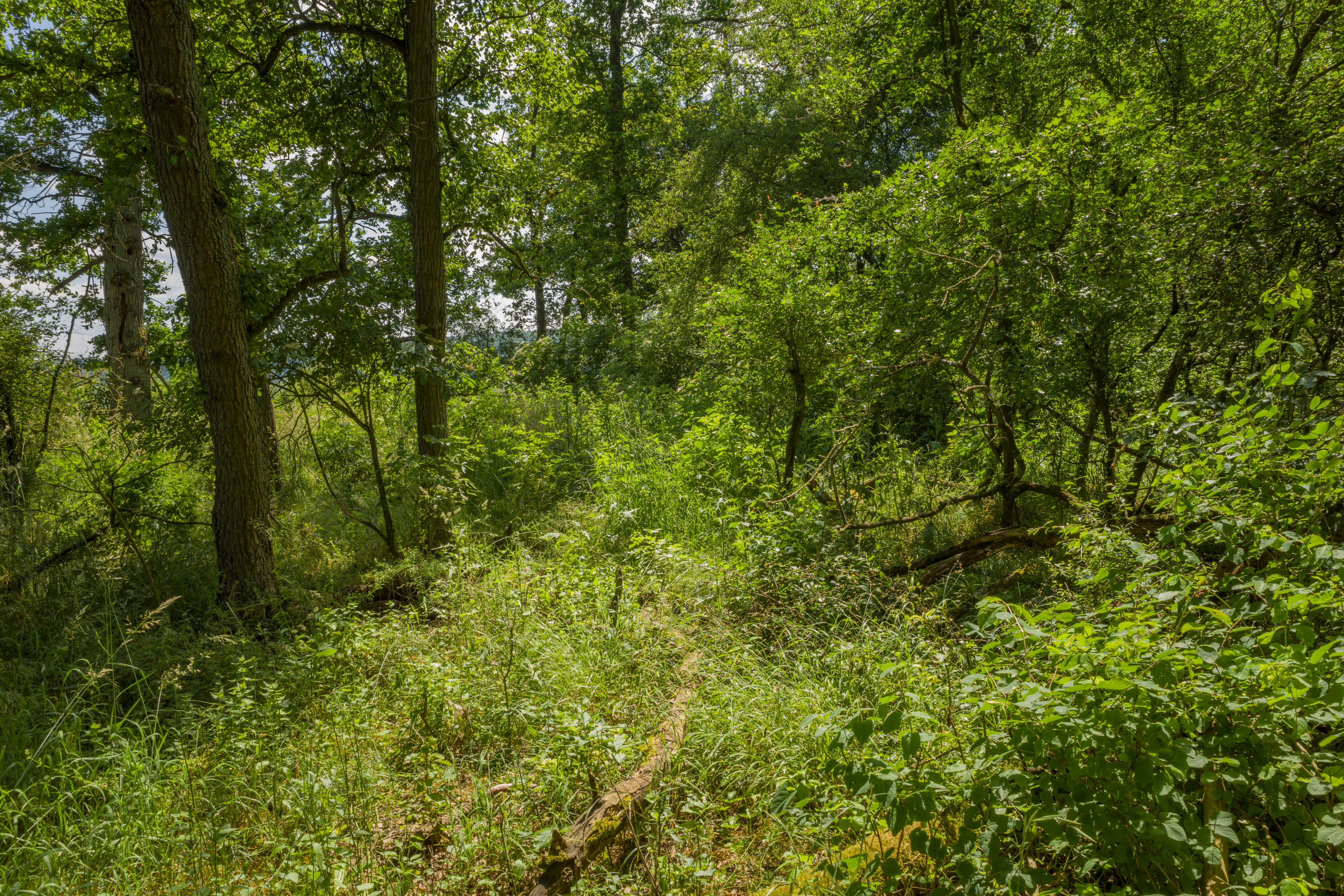
A narrow dirt path winds through a dense, lush green forest with tall trees and thick undergrowth.
A narrow, overgrown trail winding through the dense green forest of the Lachenwäldchen nature reserve.

Lachenwäldchen history and protected-area timeline

The nature reserve Lachenwäldchen was officially placed under protection in 1961, giving it a designation number of 136 within Thuringia's system of Naturschutzgebiete. Its establishment reflects the broader German tradition of identifying and protecting ecologically valuable local sites during the mid-twentieth century, when systematic ecological surveying began to inform conservation policy across the country.

In 2005, a comprehensive faunistic analysis of the reserve was published in the Thüringer faunistische Abhandlungen. This study documented 202 beetle species within the small woodland area, with a notable proportion of species judged to be of faunistic and zoogeographic significance. The publication served as a scientific validation of the reserve's conservation value and helped define its standing within regional biodiversity assessments.

Lachenwäldchen landscape and geographic character

Lachenwäldchen occupies a gentle, low-relief stretch of woodland terrain in southern Thuringia, characteristic of the rolling countryside south of the Thuringian central uplands. The reserve sits in a rural setting where fields, villages, and small roads define the surrounding land use, rather than dramatic topographic features.

The protected site lies between the villages of Gompertshausen to the northwest and Gellershausen to the east, both of which belong to the town of Heldburg. The K 503 district road traces parts of the western and northern boundary of the area, while the L 2671 state road runs along the northeastern side. Just outside the northeastern edge of the reserve, the Stausee Westhausen reservoir provides a notable nearby water feature within the broader landscape.

The woodland itself, while not described in dramatic topographic terms, offers the kind of closed forest habitat with stable microclimates, leaf litter, and decaying wood structures that support specialist species. The overall landscape context places Lachenwäldchen within a mosaic of forest patches, agricultural land, and small settlements typical of southern Thuringia's countryside.

Lachenwäldchen ecosystems, habitats, and plant life

The ecological character of Lachenwäldchen is defined primarily by its woodland habitat, which functions as a refuge for forest-dependent flora and fauna, particularly invertebrates that depend on undisturbed forest-floor conditions and decaying wood. The reserve's protected status since 1961 has allowed mature forest structures to persist over decades, providing continuity in habitat features such as leaf litter accumulation, deadwood presence, and stable microclimates.

The beetle fauna documented in the reserve reflects this ecological stability. Many of the recorded species are associated with mature deciduous or mixed forest, including ground beetles, bark-associated species, and wood-boring beetles that depend on old trees and decaying timber. Such species collectively indicate that the woodland retains the structural complexity required by specialist forest invertebrates.

As part of the regional network of protected areas in Landkreis Hildburghausen, Lachenwäldchen contributes to broader ecological connectivity in southern Thuringia. Even within its modest footprint, it represents a functioning example of how small woodland reserves maintain forest habitat quality within an otherwise heavily managed agricultural and settlement landscape.

Lachenwäldchen wildlife and species highlights

The wildlife profile of Lachenwäldchen is dominated by its invertebrate fauna, particularly its rich beetle community. A 2005 survey published in the Thüringer faunistische Abhandlungen documented 202 beetle species, an unusually diverse count for a reserve of its small size. Among the species recorded, several are considered faunistically and zoogeographically noteworthy.

Ground beetles such as Carabus arvensis and Pterostichus melas indicate the presence of stable forest-floor habitats. Saproxylic and wood-associated species like Eucnemis capucina, Dirhagus pygmaeus, Dorcatoma robusta, and Hylis olexai point to the importance of decaying wood microhabitats within the woodland. Additional notable species include Malthinus seriepunctatus, Malthinus glabellus, Trachys fragariae, Trinodes hirtus, Airaphilus elongatus, Euheptaulacus villosus, Tachys bistriatus, and Amphimallon atrum.

While the available documentation focuses heavily on beetles, the broader forest habitat likely supports additional groups of forest wildlife, including small mammals, breeding birds typical of mature woodland, and a range of forest-floor invertebrates. The reserve's protection status preserves these communities by limiting disturbance and maintaining habitat continuity over the long term.

Lachenwäldchen conservation status and protection priorities

The conservation significance of Lachenwäldchen rests on its role as a long-protected woodland refuge within an intensively used agricultural and settlement landscape. Classified as an IUCN Category IV Habitat/Species Management Area, the reserve is managed to support the persistence of habitat features and species populations that depend on stable forest conditions.

Since its designation in 1961, the reserve has provided decades of habitat continuity, allowing forest structures, microhabitats, and specialist species communities to persist. The 2005 publication in the Thüringer faunistische Abhandlungen validated this conservation value scientifically, demonstrating the presence of 202 beetle species and identifying a meaningful subset of these as faunistically and zoogeographically notable.

Within the broader network of protected sites in Landkreis Hildburghausen, Lachenwäldchen contributes a small but specialized woodland component. Its value lies less in scale and more in ecological depth, serving as a working example of how targeted protection of small forest patches can conserve specialist biodiversity in Central Europe.

Lachenwäldchen cultural meaning and human context

The landscape surrounding Lachenwäldchen carries the cultural imprint of southern Thuringia's rural settlement history. The nearby communities of Gompertshausen and Gellershausen, both part of the town of Heldburg, reflect patterns of small village organization and mixed land use that have shaped this part of the region for centuries.

The reserve itself, while primarily an ecological resource, fits within a broader cultural landscape where woodlands, fields, and villages are tightly interwoven. Roads such as the K 503 and L 2671, along with features like the Stausee Westhausen reservoir to the northeast, illustrate the integration of natural areas within the working landscape of the area.

Top sights and standout views in Lachenwäldchen

Lachenwäldchen offers a focused case study in the value of small woodland reserves. Its standout features include its 202 documented beetle species, the long continuity of habitat protection since 1961, and its position within the network of Thuringian Naturschutzgebiete in Landkreis Hildburghausen.

The reserve is also notable for the presence of decaying wood microhabitats that support rare saproxylic species, and for its integration into the cultural and agricultural landscape of southern Thuringia near Heldburg. Even at just 45.8 hectares, it demonstrates how compact, well-managed forest reserves can maintain forest-specialist biodiversity.

Best time to visit Lachenwäldchen

Given its character as a small, quiet woodland nature reserve rather than a major tourist destination, the most rewarding times to experience Lachenwäldchen are during the warmer months from late spring through early autumn, when woodland insect activity is at its peak and forest paths are most accessible.

Late spring and early summer tend to bring heightened beetle activity and vocal woodland birdlife, while early autumn offers stable weather and the visual character of mature deciduous woodland. Winter visits may offer quieter, more contemplative woodland experiences, though reduced insect activity and colder conditions limit chances of observing the reserve's most notable invertebrate fauna.

Monthly climate preview

Track monthly temperature ranges and precipitation averages across the park coordinate

Lachenwäldchen Climate Normals and Long Term Temperature Patterns

Long term climate data for Lachenwäldchen reveals measured temperature variations and precipitation distribution across twelve recorded periods. Accessing the complete monthly profile provides detailed historical metrics and comparative meteorological data for the protected area.
Annual mean8 °C
-2 °C18 °C
Jan-2°
Feb-1°
Mar
Apr
May12°
Jun16°
Jul18°
Aug18°
Sep13°
Oct
Nov
Dec-1°
Warmest month
July

18.2 °C

Coolest month
January

-1.8 °C

Wettest month
July

2.6 mm/day

Driest month
April

1.4 mm/day

Park location guide

Geography guide, regional context, and park location map for Lachenwäldchen

Lachenwäldchen park geography, regions, and map view in Germany

Understand where Lachenwäldchen sits in Germany through a broader geographic reading of the surrounding landscape, nearby location context, and its mapped position within the national park landscape.

How Lachenwäldchen fits into Germany

Germany is a federal republic in Western and Central Europe with a population of over 83 million across sixteen constituent states. It is Europe's largest economy by nominal GDP and a major global exporter and importer. The capital is Berlin, and the country borders Denmark, Poland, Czech Republic, Austria, Switzerland, France, Luxembourg, Belgium, and the Netherlands.

Wider geography shaping Lachenwäldchen in Germany

Germany is located in Western and Central Europe, spanning 357,022 km². It borders Denmark to the north, Poland and the Czech Republic to the east, Austria and Switzerland to the south, and France, Luxembourg, Belgium, and the Netherlands to the west. The country has coastlines on the Baltic Sea and North Sea to the north, with the Alps located in the southern region.

Map view of Lachenwäldchen

Use this park location map to pinpoint Lachenwäldchen in Germany, understand its exact geographic position, and read its mapped placement within the surrounding landscape more clearly.

Pigeon | © OpenStreetMap contributors

Location context for Lachenwäldchen

Thuringia

Visual reference guide to the forest terrain, microhabitats, and protected scenery of Lachenwäldchen

Lachenwäldchen Photos and Woodland Landscapes in Southern Thuringia

Visual records capture the gentle rolling woodland terrain, closed forest floor habitats, and decaying wood structures that define the nature reserve. Observing these protected-area environments clarifies how small forest patches maintain specialized invertebrate communities within southern Thuringia.

A narrow dirt path winds through a dense, lush green forest with tall trees and thick undergrowth.

Park atlas

Compare nearby woodland reserves and regional conservation landscapes

Parks Near Lachenwäldchen and Surrounding Protected Natural Areas

Browse other parks near Lachenwäldchen to examine similar woodland reserves and protected landscapes across southern Thuringia. Extending your regional comparison reveals how small forest habitats and specialized nature reserves connect within the broader surrounding terrain.
A watercolor painting of a rolling green landscape with forest patches and distant mountains under a soft sunset sky.
Nature reserveThuringia
About 3 km away#1 closest

Northeast

Am Pfingsthut Nature Reserve: Mapped Protected Landscapes in Southern Thuringia

Historic woodland habitat and regional conservation mosaic.

Located in the district of Hildburghausen, Am Pfingsthut represents a significant nature reserve with over fifty years of conservation history. The site contributes to a connected regional network of protected forested habitats and open meadows, showcasing the transition between rural settlement areas and the natural terrain of southern Germany.

Area
0.334 km²
Established
1967
IUCN
IV
Nature reserveThuringia
About 16 km away#2 closest

North

Werra bis Treffurt mit Zuflüssen: Protected River and Floodplain Network in Thuringia

Mapping an extensive 191 kilometer Natura 2000 river corridor.

The Werra bis Treffurt mit Zuflüssen protected area serves as a vital ecological corridor in Thuringia. This site encompasses a complex mosaic of fast-flowing highland brooks, expansive floodplain meadows, inland salt sites, and rare dissolution lakes. Its geography bridges high-altitude source regions with lower river valleys, creating a distinctive landscape transect that supports essential freshwater habitats and rare aquatic species across the state.

Area
22.6 km²
Established
2008
IUCN
IV
Relief
Mixed relief
A soft watercolor painting of a winding river flowing through green rolling hills and meadows under a hazy, bright sky.
Protected landscapeBavaria
About 33 km away#3 closest

Southeast

Naturpark Fränkische Schweiz, Frankenjura: An Atlas of Bavarian Karst and Forested Landscapes

Protected landscape geography within the northern Franconian Jura.

Naturpark Fränkische Schweiz, Frankenjura is a landmark protected area covering over 2,300 square kilometers across Bavaria. Its terrain is defined by a rhythmic sequence of limestone plateaux, winding river valleys, and dolomite formations, balanced by the quieter, pine-dominated reaches of the Veldensteiner Forst. This atlas entry details the park's geological complexity and its significant role in regional conservation.

Area
2,335.44 km²
Established
1968
Relief
Upland
Climate
Temperate
A horizontal watercolor painting showing soft, light-colored rolling hills and distant mountain ridgelines, with clusters of green trees in the foreground.
Nature reserveBavaria
About 37 km away#4 closest

Southeast

Naturwald Vierzehnheiligen Protected Area and Bavarian Forest Geography

Nature reserve featuring old-growth deciduous stands and limestone slope terrain

Naturwald Vierzehnheiligen comprises a vast, strictly protected forest in Upper Franconia, Germany. Spanning the foothills of the northern Franconian Jura, this reserve is defined by its structurally diverse canopy, moist ravine habitats, and limestone geological formations. It provides a essential study in non-intervention woodland management, serving as a critical refuge for broadleaved-forest species within the regional Bavarian landscape.

Area
5.413 km²
Established
2020
Relief
Upland
Climate
Temperate
A soft watercolor painting of a rolling forested landscape with green hills and trees on a white background.
Nature reserveBayern
About 38 km away#5 closest

South

Naturwald Knetzberge-Böhlgrund Nature Reserve and Steigerwald Forest Geography

A mapped overview of protected broadleaf forests in Lower Franconia.

Spanning over 800 hectares, Naturwald Knetzberge-Böhlgrund is a major protected forest entity in the Steigerwald that integrates mature stands, deadwood habitats, and steep valley topographies. This area offers a unique perspective on natural forest succession and ecological preservation within the German landscape, marked by its distinct sandstone ridges and high biodiversity.

Area
8.474 km²
Established
2020
Relief
Mountain
Climate
Temperate
Protected landscapeBavaria
About 38 km away#6 closest

East

Naturpark Frankenwald: Geographic Profile of Bavaria's Forested Protected Landscape

A vast, interconnected upland spanning the Bavaria and Thuringia border

Naturpark Frankenwald functions as a large-scale managed nature preserve that integrates cultural heritage with ecological conservation. The terrain consists of gentle mountainous ridges, narrow river valleys, and extensive mixed forests that form a continuous landscape belt across northern Bavaria. This profile provides an overview of the regional geography, boundary extent, and the natural features that define this significant central German upland area.

Area
1,023 km²
Established
1973
Relief
Upland
Climate
Temperate
A horizontal watercolor painting showing a soft, natural landscape with rolling hills in the background, a line of trees in the midground, and a meadow with light wildflowers in the foreground.
Nature reserveSchweinfurt
About 41 km away#7 closest

Southwest

Saumain in der Stadt Schweinfurt Nature Reserve: Protected Main River Floodplain Geography

A vital riverine nature reserve in Schweinfurt, Bavaria

Spanning over 11 hectares within the city limits of Schweinfurt, this nature reserve protects an isolated, stable arm of the River Main. The area functions as a critical riparian habitat, featuring still water zones, emergent reeds, and hardwood floodplains that provide essential refuge in an urbanized region of Lower Franconia. Explore the geographic footprint of this protected site within the context of the greater Maintal landscape.

Area
0.116 km²
Established
1993
Relief
Lowland
Climate
Temperate
Nature reserveLandkreis Haßberge
About 41 km away#8 closest

South

Naturwald Wotansborn: A Protected Old-Growth Beech Reserve in the Heart of the Steigerwald

Ancient forest geography within the Haßberge district

Naturwald Wotansborn is a protected woodland enclave that preserves centuries-old beech trees and high concentrations of deadwood habitat. Located in the Steigerwald of Landkreis Haßberge, this reserve offers a window into natural forest cycles, housing the historic Wotansborn spring and a vital corridor for amphibian life along the Erlesbach stream.

Area
0.033 km²
Established
2020
IUCN
IV
Relief
Upland

Common questions about visiting, size, designation, and location context for Lachenwäldchen

Lachenwäldchen FAQs for park facts, access, geography, and protected area context

Find quick answers about Lachenwäldchen, including protected-area facts, park geography, trail and visitor context, and how the park fits into its surrounding country and regional landscape.
MoriAtlas Explorer

Continue Your Protected Areas Search Across the Global Atlas

Deepen your exploration by continuing the structured search for national parks and protected areas worldwide. Utilize the comprehensive filtering capabilities to compare different conservation landscapes and refine your understanding of global park geography. Discover more about the distribution and characteristics of protected natural areas.

Global natural geography