Mori Atlas logo
National parkLake Butig National Park

Explore the mapped boundaries and natural terrain of this designated national park in the Philippines.

Lake Butig National Park: Protected Landscape and Geographic Atlas Context in Lanao del Sur

Lake Butig National Park serves as a critical protected area within the Philippine archipelago, situated in the region of Lanao del Sur. This page offers detailed geographic context and atlas-style exploration for understanding the park's mapped boundaries and natural landscape. Discover the terrain and regional setting of this designated national park, providing essential data for geographic analysis and protected land exploration.

LakeForestMountain landscapeProtected areaVolcanic lakeBirdwatching

Lake Butig National Park

National park

Park overview

Structured park overview, official facts, and landscape profile for Lake Butig National Park

Lake Butig National Park park facts, protected area profile, and essential visitor context
Review the core facts for Lake Butig National Park, including designation, size, terrain, visitor scale, habitats, and operating context in one park-focused overview.

About Lake Butig National Park

Lake Butig National Park represents a protected landscape of considerable local significance in the southern Philippines. The park's core feature is Lake Butig, a volcanic lake nestled in the Butig Mountain range at an elevation of 500 meters above sea level. The surrounding forest ecosystem forms an integral part of the protected area, creating a cohesive natural unit that supports biodiversity while offering recreational opportunities for visitors.

The park's location in Lanao del Sur places it within a region of rich cultural and ecological diversity. The municipality of Butig provides the human context for the protected area, with local communities having longstanding connections to the landscape. The park serves multiple functions: as a biodiversity habitat, as a watershed protection zone, and as a destination for tourism and environmental education. The establishment of the national park in 1965 reflected early Philippine recognition of the need to conserve distinctive natural areas, with Lake Butig selected for its scenic and ecological values.

Quick facts and research context for Lake Butig National Park

Lake Butig National Park covers 68 hectares in Butig municipality, Lanao del Sur, on Mindanao Island, Philippines. The protected area was established on May 5, 1965, through Republic Act No. 4190 and is managed by the Department of Environment and Natural Resources. The lake sits at 500 meters elevation at the base of the Butig Mountain range, with Mount Makaturing and Latukan as prominent nearby peaks. The park is accessible via the Lake Lanao Circumferential Road, approximately 30 kilometers from Marawi City.

Park context

Deeper park guide and search-rich context for Lake Butig National Park

Lake Butig National Park history, landscape, wildlife, and travel context
Explore Lake Butig National Park through its history, landscape character, ecosystems, wildlife, conservation priorities, cultural context, and seasonal travel timing in a structured park guide built for atlas discovery and search intent.

Why Lake Butig National Park stands out

Lake Butig National Park is best known for its scenic volcanic lake set amid forested mountain terrain in the heart of Lanao del Sur. The park's elevated location provides a cooler microclimate compared to the surrounding lowlands, making it a natural destination for visitors seeking relief from tropical heat. The surrounding forest harbors notable bird species including hornbills, parrots, woodpeckers, and wild ducks, while the broader wildlife community includes Philippine monkeys, Philippine deer, and wild pigs. The combination of the lake, forest, and mountain backdrop creates a distinctive protected landscape that serves both conservation and recreation functions.

Lake Butig National Park history and protected-area timeline

Lake Butig National Park was established on May 5, 1965, through the passage of Republic Act No. 4190, which formally designated the area as a national park of the Philippines. This legislative action represented the country's mid-20th century approach to natural resource conservation, identifying areas of special scenic and ecological value for permanent protection. The declaration came during a period when the Philippines was building its system of protected areas across the archipelago.

The park's establishment reflected recognition of Lake Butig's distinctive character as a volcanic lake in a mountainous setting. The subsequent decades saw the park included in the broader framework of Philippine protected areas under the management of the Department of Environment and Natural Resources. The IUCN Category V classification that the park currently holds was assigned later, recognizing its status as a protected landscape where natural and cultural values intertwine.

Lake Butig National Park landscape and geographic character

The landscape of Lake Butig National Park centers on a volcanic lake set within the Butig Mountain range in Lanao del Sur. The terrain rises from the lake shoreline up the surrounding forested slopes, creating a basin-like setting defined by mountain peaks including Mount Makaturing and the Latukan volcanic complex. The lake itself occupies a natural depression formed by volcanic activity, with its waters reflecting the surrounding forest-covered slopes.

The elevation of approximately 500 meters places the park in a transitional zone between lowland and higher mountain environments. This elevation contributes to the cooler climate that distinguishes the area from the warmer lowlands of Mindanao. The forest surrounding the lake forms a green buffer that enhances the scenic quality of the landscape while serving important ecological functions. The mountain backdrop, particularly the visually prominent peaks that frame the lake, contributes significantly to the park's visual identity.

Lake Butig National Park ecosystems, habitats, and plant life

The natural environment of Lake Butig National Park encompasses a lake ecosystem integrated with surrounding forest habitats. The forest areas contain diverse plant communities that support the wildlife present in the park. The elevation and mountain setting create conditions that support species adapted to more temperate environments than typical tropical lowlands, contributing to the ecological distinctiveness of the area.

The park's biodiversity includes several bird species that inhabit the forest canopy and lake margins. Hornbills, parrots, woodpeckers, and wild ducks have been recorded in the area, representing forest-dwelling and water-associated species. The surrounding forest also provides habitat for mammalian species including Philippine monkeys, Philippine deer, and wild pigs. This assemblage of wildlife, while not exhaustive, indicates the ecological value of the protected area as a habitat in the Mindanao region.

Lake Butig National Park wildlife and species highlights

The wildlife community of Lake Butig National Park reflects the diverse habitats provided by the lake and surrounding forest. The avian fauna includes at least four documented bird groups: hornbills known for their distinctive large bills, parrots representing tropical forest birds, woodpeckers associated with tree-dwelling invertebrate feeding, and wild ducks utilizing the lake habitat. These species groups indicate a functional ecosystem with appropriate food sources and nesting conditions.

Mammalian fauna documented in the park includes Philippine monkeys, which are arboreal primates adapted to forest environments, Philippine deer representing native ungulate species, and wild pigs which are common throughout Philippine forests. The presence of these species demonstrates that the protected area maintains ecological connectivity that allows wildlife to inhabit and move through the forest surrounding the lake.

Lake Butig National Park conservation status and protection priorities

Lake Butig National Park holds IUCN Category V status, reflecting its designation as a protected landscape where conservation objectives work in balance with sustainable human use. This category recognizes areas that contain characteristic landscapes of significant ecological, biological, cultural, and scenic value, where the interaction of people and nature has produced areas of distinct character. The park's protected status under Philippine law, established through Republic Act No. 4190, provides the legal framework for its conservation management.

The park's conservation significance derives from its lake and forest ecosystem in a mountainous setting that supports biodiversity within the Mindanao region. The forest surrounding the lake functions as a watershed buffer, protecting water quality and soil stability in the catchment area. The presence of wildlife species including endemic Philippine fauna contributes to the park's value as a habitat within the broader conservation network of the archipelago.

Lake Butig National Park cultural meaning and human context

Lake Butig National Park is situated in Lanao del Sur, a province with deep cultural connections to the land and lakes of Mindanao. The municipality of Butig, where the park is located, forms part of the ancestral homeland of the Maranao people, an indigenous community with rich traditions tied to the landscapes of the Lake Lanao basin. The lake itself has been a part of the local cultural landscape long before its designation as a protected area.

The park's accessibility via the Lake Lanao Circumferential Road connects it to the broader cultural and geographic context of the region. The road links Lake Butig to Marawi City and the larger Lake Lanao, around which Maranao culture developed historically. This cultural context adds depth to the park's identity beyond its purely ecological values, situating it within a landscape shaped by human presence and cultural practice over generations.

Top sights and standout views in Lake Butig National Park

Lake Butig National Park offers visitors a scenic volcanic lake experience in a mountainous forest setting at 500 meters elevation. The park provides opportunities for birdwatching, with hornbills, parrots, woodpeckers, and wild ducks among the species present in the surrounding forest. The cooler climate at this elevation offers a contrast to the tropical heat of lowland Mindanao. The mountain backdrop of Mount Makaturing and Latukan enhances the visual appeal of the lakeside setting. The park is readily accessible from Marawi City via a 30-kilometer journey along the Lake Lanao Circumferential Road.

Best time to visit Lake Butig National Park

The park can be visited throughout the year, though the drier months from March to May typically offer more predictable conditions for outdoor activities. The cooler elevation of 500 meters provides comfortable temperatures year-round compared to lower elevations in the region. Visitors seeking to observe wildlife may find the early morning hours most productive, particularly in the forest areas surrounding the lake where bird activity is highest. The dry season generally provides clearer views of the mountain backdrop and more comfortable conditions for exploring the park's trails and shoreline areas.
Park location guide

Geography guide, regional context, and park location map for Lake Butig National Park

Lake Butig National Park park geography, regions, and map view in Philippines
Understand where Lake Butig National Park sits in Philippines through a broader geographic reading of the surrounding landscape, nearby location context, and its mapped position within the national park landscape.

How Lake Butig National Park fits into Philippines

The Philippines, officially the Republic of the Philippines, is an archipelagic nation in Southeast Asia comprising approximately 7,641 islands categorized into three main geographical divisions: Luzon, Visayas, and Mindanao. Located in the western Pacific Ocean, it shares maritime borders with Taiwan, Japan, Palau, Indonesia, Malaysia, Vietnam, and China. Manila serves as the capital city, while Quezon City is the most populated city, both within Metro Manila.

Wider geography shaping Lake Butig National Park in Philippines

The Philippines is an archipelagic nation in Southeast Asia, positioned in the western Pacific Ocean. Its islands are bounded by the South China Sea to the west, Philippine Sea to the east, and Celebes Sea to the south. The country shares maritime borders with Taiwan to the north, Japan to the northeast, Palau to the east and southeast, Indonesia to the south, Malaysia to the southwest, Vietnam to the west, and China to the northwest.

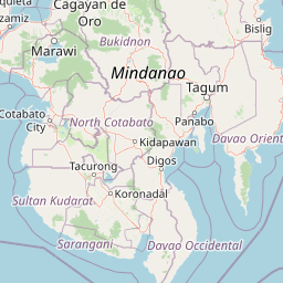
Map view of Lake Butig National Park

Use this park location map to pinpoint Lake Butig National Park in Philippines, understand its exact geographic position, and read its mapped placement within the surrounding landscape more clearly.

Pigeon | © OpenStreetMap contributors

Location context for Lake Butig National Park

Lanao del Sur
Park atlas

Compare protected landscapes across the Mindanao region, tracing the geographic spread of natural reserves.

Explore Other Protected Areas and National Parks Near Lake Butig National Park
Browse national parks and protected areas in the geographic region surrounding Lake Butig National Park, tracing the spread of conservation landscapes across Mindanao. Compare these protected areas by their terrain, ecological features, and conservation status, gaining broader regional context and discovery value for further exploration.
National parkLanao del Sur

Pantuwaraya Lake National Park: National Park Atlas and Mapped Landscape

Explore the protected area and regional geography of Lanao del Sur.

Understand Pantuwaraya Lake National Park as a defined protected landscape and a significant national park within the Philippines. This entry focuses on its geographic placement in Lanao del Sur, providing context for its mapped boundaries and natural features. Users can explore its representation within a broader atlas of protected lands, gaining insight into its role and landscape identity.

Area
0.2 km²
Established
1965
IUCN
V
Climate
Tropical
National parkLanao del Sur

Salikata National Park: Explore Philippines National Park Geography

Mapped protected area boundaries and regional context.

Investigate Salikata National Park, a key protected area designated as a national park within Lanao del Sur, Philippines. This detailed view provides essential context for understanding its mapped boundaries, its place in the regional geography, and its significance as a protected landscape. Discover the unique geographic attributes that define Salikata National Park for atlas-based exploration.

Established
1965
IUCN
V
Relief
Mountain
Climate
Tropical
National parkLanao del Sur

Sacred Mountain National Park National Park: Detailed Geographic and Protected Landscape Context

Mapped boundaries and regional geography for Sacred Mountain National Park.

Sacred Mountain National Park, a significant national park in Lanao del Sur, offers a distinct protected landscape for atlas-driven discovery. This detailed entry provides insight into its geographic scope and mapped presence, allowing for a deeper understanding of its role within the region. Explore the specific natural terrain and protected area features that define Sacred Mountain National Park, grounded in factual geographic data.

Area
0.94 km²
Established
1965
IUCN
V
Relief
Mountain
National parkMaguindanao del Norte

Mado Hot Spring National Park: Protected Geothermal Landscape in Maguindanao del Norte

Explore its therapeutic hot springs and mapped boundaries

Mado Hot Spring National Park, located in Maguindanao del Norte, Philippines, is a protected area defined by its geothermal features and therapeutic hot springs. This national park, established early in the Philippines' conservation history, offers a unique landscape centered around a warm mineral-rich natural pool. Delve into the geographic context and protected area identity of this distinctive site, understanding its role within the region's natural heritage.

Area
0.48 km²
Established
1939
IUCN
II
Scope
Terrestrial
National parkCebu

Guadalupe Mabugnao Mainit Hot Spring National Park: Protected Landscape and Watershed Geography

Explore hot springs, caves, and mapped terrain in Cebu.

Guadalupe Mabugnao Mainit Hot Spring National Park is a protected national park in Cebu, Philippines, recognized for its significant watershed function and unique natural features. Spanning forested highland terrain within the Mantalongon mountain range, the park protects natural hot springs, explored cave systems such as Cave Lorett, and river networks vital to local water supply. Its identity as a protected landscape offers rich opportunities for geographic exploration, mapping its boundaries, and understanding its role within the regional natural terrain and conservation efforts.

Area
0.575 km²
Established
1972
IUCN
V
Relief
Mountain
National parkPhilippines

Kuapnit Balinsasayao National Park: Philippines Old-Growth Forest and Endemic Wildlife Atlas

Explore protected landscape boundaries and mountainous terrain on Leyte Island.

Kuapnit Balinsasayao National Park stands as a key protected area within the Philippines, distinguished by its mature old-growth forests and its critical role in conserving endemic bird species unique to the Eastern Visayas. Located on Leyte Island within the mountainous terrain of the Anonang-Lobi Mountain Range, the park's protected landscape identity is central to understanding its geographic significance. This park offers a valuable entry point for exploring the mapped natural features and conservation importance of protected areas across the Philippine archipelago.

Area
3.64 km²
Established
1937
IUCN
V
Relief
Mountain
National parkPalo

MacArthur Landing Memorial National Park: Protected Area Geography & Map Context

Explore the mapped boundaries of this national park in Palo, Philippines.

This entry details MacArthur Landing Memorial National Park, a protected national park located near Palo, Philippines. It focuses on its identity as a mapped landscape and a distinct protected area, offering insights into its geographic context and atlas presence. Understanding this park involves exploring its mapped boundaries and its contribution to the regional protected area landscape, providing a factual basis for geographic discovery.

Area
0.068 km²
Established
1977
Relief
Lowland
Climate
Tropical
National parkPhilippines

Bulabog Putian National Park: Philippines National Park Geographic Context and Mapped Boundaries

Discover the protected landscape identity and regional atlas significance.

Bulabog Putian National Park stands as a designated national park in the Philippines, offering valuable insights for geographic and protected-area exploration. Users can understand its specific location and mapped presence within the country's natural landscape, contributing to a structured atlas of conservation areas. This entry focuses on the park's identity and geographic setting for informed discovery.

Area
8.543 km²
Established
1961
IUCN
V
Relief
Mountain

Common questions about visiting, size, designation, and location context for Lake Butig National Park

Lake Butig National Park FAQs for park facts, access, geography, and protected area context
Find quick answers about Lake Butig National Park, including protected-area facts, park geography, trail and visitor context, and how the park fits into its surrounding country and regional landscape.
MoriAtlas Explorer

Continue Your Protected Areas Search Across the Global Atlas

Deepen your exploration by continuing the structured search for national parks and protected areas worldwide. Utilize the comprehensive filtering capabilities to compare different conservation landscapes and refine your understanding of global park geography. Discover more about the distribution and characteristics of protected natural areas.

Global natural geography