

Mori Atlas logo
Wildlife reserveLake Chad Game Reserve

Discover the complex hydrology and expansive floodplain geography of this major Sahelian wildlife reserve.

Lake Chad Game Reserve: Mapping the Protected Wetlands and Sahelian Terrain of Borno, Nigeria

Lake Chad Game Reserve represents a critical protected wetland complex situated on the former lakebed of the Nigerian section of Lake Chad. Spanning across the Borno region, this area features an intricate mosaic of permanent and seasonal swamps, floodplains, and riverine corridors shaped by the Komadugu Yobe, Ngadda, and Yedseram systems. This distinctive Sahelian landscape serves as a vital hydrological node, defined by heavy vertisol soils and a dynamic flood pulse that defines the regional ecology.

wetlandsRamsar siteSahelmigratory birdswaterbirdsfloodplain

Lake Chad Game Reserve

Wildlife reserve

Park overview

Structured park overview, official facts, and landscape profile for Lake Chad Game Reserve

Lake Chad Game Reserve park facts, protected area profile, and essential visitor context

Review the core facts for Lake Chad Game Reserve, including designation, size, terrain, visitor scale, habitats, and operating context in one park-focused overview.

About Lake Chad Game Reserve

Lake Chad Game Reserve is one of the most important wetland conservation areas in West Africa, located in the far northeast of Nigeria in the state of Borno. It occupies a strategic position at the intersection of three international borders, with Niger to the north, Chad to the east, and Cameroon to the southeast. To the west and southwest, the reserve boundary follows the old shoreline of Lake Chad, anchoring the area in the geographic and ecological legacy of one of Africa's most iconic lakes.

The defining story of the reserve is ecological transformation. Until the 1970s, much of this territory was submerged beneath the open waters of Lake Chad. As the lake retreated over the following decades, the exposed lakebed gave rise to a complex network of permanent and seasonal lakes, swamps, and floodplains fed by the Komadugu Yobe, Ngadda, and Yedseram river systems. This shift turned a once-deep lake basin into a dynamic wetland mosaic that shifts in size and character with the seasonal flood pulse.

The reserve's identity is shaped by its Sahel context. Vegetation is dominated by seasonally flooded grasslands and low bush savanna, locally known as fadama vegetation, interspersed with tall stands of Typha domingensis along watercourses and dense thickets of Mimosa pigra along wetland margins. Scattered taller trees such as Acacia nilotica and the doum palm Hyphaene thebaica dot the landscape, while gallery forests develop along the larger river channels. Soils are predominantly heavy clay vertisols, locally called firki, which retain water and support the seasonal flooding that defines the area.

Climate reinforces the wetland character. The region has a tropical wet-and-dry climate with a sharply divided rainy and dry season, modest annual rainfall of roughly 300 to 400 millimeters, and very high evaporation potential. These conditions combine to produce dramatic seasonal shifts, with water arriving from August onward as the West African monsoon strengthens, peaking in the floodplains between December and February when river systems deliver their highest flows, and reaching maximum wetland extent in February before receding into the long dry season.

Taken together, these factors make Lake Chad Game Reserve a significant refuge for biodiversity in an otherwise arid landscape and a key node within the broader Sahelian wetland system.

Quick facts and research context for Lake Chad Game Reserve

Lake Chad Game Reserve lies in the Borno State of northeastern Nigeria, covering roughly 6,073 square kilometers and sitting at an average elevation of about 280 meters above sea level. The reserve is bordered by Niger to the north, Chad to the east, and Cameroon to the southeast, with the old Lake Chad shoreline forming its western and southwestern limits. It was designated as a Ramsar Wetland of International Importance in April 2008 and is classified by the IUCN as a Category IV protected area, reflecting its focus on habitat and species management. The nearest major town is Maiduguri, with the reserve also extending toward the settlements of Bosso, Kurnawa, Baga, Marte, and Gambourou.

Protection and recognition

Documented terrestrial protection framework established in 2008

Lake Chad Game Reserve Protection Status and Designated History

Lake Chad Game Reserve maintains a documented terrestrial protection status established in 2008 within its regional conservation framework. Official records compile the recorded designation timeline and management scope without additional international recognition sources.

Protection details

Protection scope
Terrestrial
Designated year
2008
Transboundary protection
No
Park context

Deeper park guide and search-rich context for Lake Chad Game Reserve

Lake Chad Game Reserve history, landscape, wildlife, and travel context

Explore Lake Chad Game Reserve through its history, landscape character, ecosystems, wildlife, conservation priorities, cultural context, and seasonal travel timing in a structured park guide built for atlas discovery and search intent.

Why Lake Chad Game Reserve stands out

Lake Chad Game Reserve is best known for its expansive wetland mosaic that emerged from the shrinking of Lake Chad, and for its exceptional importance to both resident and migratory waterbirds. More than 300 bird species have been recorded in the wetlands, with several species documented as new visitors to Nigeria. The reserve also stands out for its seasonal hydrological dynamics, where flooding from the Komadugu Yobe, Ngadda, and Yedseram river systems transforms the landscape between the late monsoon and the early dry season. Its combination of Sahel setting, Ramsar recognition, and large flooded grassland and swamp habitats gives it a distinctive profile among West African protected areas.

Lake Chad Game Reserve history and protected-area timeline

Lake Chad Game Reserve, in its modern form, emerged directly from one of the most dramatic environmental changes in twentieth century West Africa: the progressive shrinking of Lake Chad. Until the 1970s, the area that now makes up the reserve lay beneath the open waters of the Nigerian portion of the lake. As Lake Chad retreated through the 1970s and 1980s, its former lakebed dried out, exposing a vast plain that gradually filled with a network of permanent and seasonal lakes, swamps, and floodplains fed by the Komadugu Yobe, Ngadda, and Yedseram rivers.

The transformation of the area from open lake to seasonal wetland was the catalyst for formal protection. Decades later, on 30 April 2008, the site was formally recognized under the title Lake Chad Wetlands in Nigeria and inscribed on the List of Wetlands of International Importance under the Ramsar Convention. The IUCN has since classified the area as a Category IV protected landscape, designating it as a habitat and species management area requiring active stewardship. This recognition reflects the growing recognition of the area's ecological value despite the loss of the open lake that originally lay over it.

Lake Chad Game Reserve landscape and geographic character

The landscape of Lake Chad Game Reserve is defined by flatness and water rather than by dramatic relief. The reserve sits at an average elevation of around 280 meters above sea level and extends across a broad plain that once formed the bed of the Nigerian section of Lake Chad. Its outer limits are shaped as much by political geography as by terrain: the Niger border defines the northern edge, the Chad border the east, and the Cameroon border the southeast, while the former lake shoreline curves across the west and southwest.

Within these boundaries lies a shifting mosaic of lakes, swamps, and flood-prone grasslands. Permanent water bodies coexist with seasonal pools that swell and shrink with annual flooding, while the river corridors of the Komadugu Yobe, Ngadda, and Yedseram introduce linear channels of denser vegetation through the otherwise open floodplain. Soils throughout most of the reserve are heavy cracking clays classified as vertisols and known locally as firki, which help retain water and shape the distinctive flood pulse that transforms the landscape each year.

Lake Chad Game Reserve ecosystems, habitats, and plant life

Ecologically, Lake Chad Game Reserve is a wetland refuge embedded in a predominantly dry Sahel setting. The vegetation follows the rhythm of flooding, with seasonally inundated grasslands and low bush savanna dominating the open areas. Locally, this pattern of seasonal flooding is captured by the Hausa term fadama, which describes the annual floodplain landscape. Tall emergent stands of Typha domingensis line waterways, while dense thickets of Mimosa pigra fringe wetland margins, and scattered taller trees such as Acacia nilotica and the doum palm Hyphaene thebaica punctuate the plain.

Along the larger river channels, gallery forests develop as denser ribbons of woody vegetation contrasting with the surrounding open floodplain. The overall ecological character of the reserve is therefore shaped by a tight interaction between hydrology, soil type, and climate. Seasonal rains and river flow determine when and where water is present, the heavy clay soils help sustain that water over extended periods, and the tropical wet-and-dry climate with high evaporation potential ensures that wetlands expand and contract on an annual cycle.

Lake Chad Game Reserve wildlife and species highlights

Wildlife significance in Lake Chad Game Reserve is dominated by its avifauna. The wetlands are especially important for waterbirds and for migratory birds from the Northern Hemisphere that use the area as a staging and wintering site along broader flyways across the Sahel.

The reserve hosts a rich and varied bird community, with more than 300 bird species recorded in the wetlands. Notably, eight of these species were documented as new visitors to Nigeria, underscoring the area's significance as a destination for birds moving across regional and intercontinental routes. Among the species of conservation concern that depend on the reserve are the Great Snipe (Gallinago media) and the Pallid Harrier (Circus macrourus), both of which highlight the reserve's role within wider international efforts to safeguard migratory and wetland-dependent bird populations.

Lake Chad Game Reserve conservation status and protection priorities

Lake Chad Game Reserve holds formal recognition on two important international levels. In April 2008, the area was inscribed on the Ramsar List of Wetlands of International Importance under the title Lake Chad Wetlands in Nigeria, joining a network of globally significant wetland sites. The IUCN separately classifies the reserve as a Category IV protected area, a designation that frames it as a habitat and species management area requiring active stewardship of its ecosystems and wildlife.

Beyond these designations, the conservation value of the reserve lies in its function as a major wetland refuge in an arid Sahelian landscape. The seasonal flood pulse, combined with the area's geographic position at the meeting point of three countries, gives it an outsized role in supporting migratory birds and sustaining wetland-dependent biodiversity. Its place within a broader network of Ramsar sites in Nigeria reinforces its importance as a regional conservation anchor.

Lake Chad Game Reserve cultural meaning and human context

The cultural framing of Lake Chad Game Reserve is closely tied to the linguistic and ecological vocabulary of its region. The wetland vegetation pattern that defines the reserve is known locally as fadama, a Hausa term referring to seasonally inundated land, while the heavy clay soils characteristic of the area are referred to as firki in regional usage. These local names reflect long-standing familiarity with the seasonal flooding dynamics of the Lake Chad basin, even as the modern reserve itself is a product of the lake's dramatic twentieth century retreat and the subsequent transformation of its former bed into a managed protected landscape.

Top sights and standout views in Lake Chad Game Reserve

Lake Chad Game Reserve's standout qualities include its origin on the former floor of Lake Chad, its scale as one of the largest protected wetland complexes in Nigeria, and its Ramsar-recognized role in supporting migratory waterbirds. The combination of Sahel climate, seasonal flooding from three river systems, and rich avifauna makes it both a regional conservation priority and a distinctive destination for understanding West African wetland ecology.

Best time to visit Lake Chad Game Reserve

Visiting Lake Chad Game Reserve is fundamentally shaped by its seasonal hydrology. The West African monsoon brings rains from May through October, but the most striking wetland conditions occur later, as the floodwaters from the Komadugu Yobe, Ngadda, and Yedseram rivers peak between December and February. By February, the wetlands reach their maximum extent and spread toward the present-day shoreline of Lake Chad, a period that also aligns with peak seasonal presence of many waterbirds and migrants. The long dry season that follows brings contracting water levels and sharp extremes of heat, with temperatures potentially reaching above 40 degrees Celsius, making the cooler flood season the most comfortable and ecologically rewarding window for visiting.

Monthly climate preview

Long term average temperature and precipitation rhythm across twelve months

Lake Chad Game Reserve Climate Normals and Monthly Weather Patterns

Representative coordinate records show average temperatures ranging from 23.13 degrees Celsius to 35.08 degrees Celsius alongside marked seasonal precipitation variations. Exploring the complete monthly profile provides detailed long term climate normals for Lake Chad Game Reserve.
Annual mean29 °C
23 °C35 °C
Jan23°
Feb26°
Mar31°
Apr34°
May35°
Jun34°
Jul31°
Aug28°
Sep29°
Oct30°
Nov27°
Dec24°
Warmest month
May

35.1 °C

Coolest month
January

23.1 °C

Wettest month
August

5.2 mm/day

Driest month
January

0 mm/day

Park location guide

Geography guide, regional context, and park location map for Lake Chad Game Reserve

Lake Chad Game Reserve park geography, regions, and map view in Nigeria

Understand where Lake Chad Game Reserve sits in Nigeria through a broader geographic reading of the surrounding landscape, nearby location context, and its mapped position within the national park landscape.

How Lake Chad Game Reserve fits into Nigeria

Nigeria is a West African federal republic spanning 923,769 km² between the Sahel and the Gulf of Guinea. It is Africa's most populous nation with over 236 million residents, composed of diverse ethnic groups including Hausa, Yoruba, Igbo, and numerous others. The country operates as a federal presidential republic with 36 states and the Federal Capital Territory, using English as its official language and possessing significant linguistic diversity with over 525 indigenous languages.

Wider geography shaping Lake Chad Game Reserve in Nigeria

Nigeria occupies West Africa between the Sahel region to the north and the Gulf of Guinea in the Atlantic Ocean to the south. It shares borders with Niger to the north, Chad to the northeast, Cameroon to the east, and Benin to the west. The country covers an area of 923,769 square kilometres.

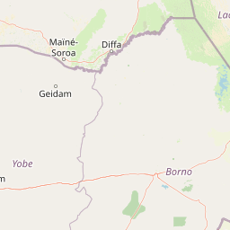
Map view of Lake Chad Game Reserve

Use this park location map to pinpoint Lake Chad Game Reserve in Nigeria, understand its exact geographic position, and read its mapped placement within the surrounding landscape more clearly.

Pigeon | © OpenStreetMap contributors

Location context for Lake Chad Game Reserve

Borno
Park atlas

Compare regional wetlands, floodplains, and contiguous Sahel habitats

Parks Near Lake Chad Game Reserve and Surrounding Protected Areas

Browse other parks near Lake Chad Game Reserve to examine contiguous wetland habitats and seasonal floodplains across the surrounding region. Extending the geographic comparison reveals broader protected landscapes and regional conservation patterns within the Sahel ecosystem.
National parkNigeria
About 154 km away#1 closest

South

Chad Basin National Park: Exploring Nigeria's Protected Natural Landscape

Mapped protected area and regional geography context.

Chad Basin National Park is a key protected landscape within Nigeria, designated as a national park. This page serves as a gateway to understanding its specific geographic identity, mapped boundaries, and its role within the country's natural terrain. Users can explore detailed information, focusing on the park's atlas-relevant features and its contribution to Nigeria's protected areas, offering a distinct view of the nation's geography.

Area
2,258 km²
Established
1991
IUCN
II
Relief
Lowland
National parkExtrême-Nord
About 157 km away#2 closest

Southeast

Parc national de Kalamaloué: A Deep Geographic Analysis of Cameroon's Yaéré Floodplain

Mapped protected landscapes along the Logone and Chari rivers.

Parc national de Kalamaloué serves as a prime case study for sudano-sahelian geography, defined by its flat terrain and the seasonal inundation of the Logone basin. The park provides an essential look at how river hydrology influences small-scale protected habitats, ranging from dense mangrove fringes to dry acacia-dominated woodlands.

Area
45 km²
Established
1972
IUCN
II
Relief
Lowland
National parkFar North Region
About 217 km away#3 closest

Southeast

Waza National Park: A Designated Protected Landscape in the Far North Region

Mapped Boundaries and Regional Geographic Context

Waza National Park stands as a vital protected natural landscape in Cameroon's Far North Region. This entry provides a deep dive into its mapped protected-area boundaries and its significance within the broader regional geography. Explore the specific landscape identity of this national park through an atlas-focused lens, understanding its terrain and context without travel logistics or visitor advice.

Area
1,700 km²
Established
1934
IUCN
II
Relief
Lowland
National parkExtrême-Nord
About 343 km away#4 closest

South

Parc national de Ma Mbed Mbed: Geography and Protected Landscape Map Details

Extrême-Nord savanna buffer and transboundary conservation corridor.

Parc national de Ma Mbed Mbed is a key protected area covering 181 square kilometers of transitional savanna in Cameroon. Its location at the edge of the Sahelian zone creates a unique ecological interface, supporting critical elephant corridors and complex water-dependent vegetation patterns that feed into transregional river basins.

Area
181 km²
Established
2009
IUCN
II
Relief
Lowland
Wildlife reserveYobe
About 365 km away#5 closest

West

Nguru Lake Wildlife Reserve: Sahelian Wetland and Floodplain Geography

A protected freshwater ecosystem in Yobe, Nigeria

Nguru Lake serves as a vital hydrological anchor within the Hadejia-Nguru wetland system. This endorheic, shallow-water environment undergoes dramatic seasonal expansion, creating a rich mosaic of marshlands and mudflats. The site stands as a key protected area within the Chad Basin landscape, offering a unique look at Sahelian water ecology and floodplain dynamics.

Area
37 km²
Relief
Lowland
Climate
Tropical
Scope
Terrestrial
National parkCameroon
About 458 km away#6 closest

South

Bouba Njida National Park: A Protected Landscape within Cameroon's National Park Atlas

Discover its mapped geography and regional context.

Bouba Njida National Park represents a key component of Cameroon's protected lands, contributing essential context to any atlas of Central African geography. As a designated national park, it offers a distinct focus for understanding mapped landscape features and the distribution of protected areas within the country. This park serves as a vital point of reference for exploring the nation's natural terrain and its significance within the broader context of regional conservation efforts.

Area
2,200 km²
Established
1980
IUCN
II
Relief
Upland
Wildlife reserveZinder
About 459 km away#7 closest

West

Mare de Lassouri Wildlife Reserve: Geographic Context and Sahel Wetland Mapping

Protecting vital aquatic habitats in the Zinder Region

Mare de Lassouri serves as a central hub for wetland conservation within the Zinder Region of Niger. This shallow freshwater basin offers a rich habitat mosaic where migratory waterbirds congregate amid bushy savanna, providing essential ecological value and sustaining local agricultural livelihoods in a resource-scarce Sahelian landscape.

Area
7.5 km²
Established
2005
Relief
Lowland
Climate
Arid
Protected areaZinder
About 467 km away#8 closest

West

Guidimouni Lake Protected Area: Wetland Geography and Zinder Region Landscape Atlas

A Ramsar-designated freshwater and saline wetland system in the Sahel.

Guidimouni Lake is a significant endorheic wetland situated within the Zinder Region of Niger. This protected area consists of a long, narrow depression featuring a rare coexistence of fresh and saline water basins. Beyond its ecological role, the site provides a critical framework for understanding the interplay between Sahelian sand plains, local water-lily habitats, and the regional agro-pastoral economy.

Area
0.6 km²
Established
2019
Relief
Lowland
Climate
Subtropical

Common questions about visiting, size, designation, and location context for Lake Chad Game Reserve

Lake Chad Game Reserve FAQs for park facts, access, geography, and protected area context

Find quick answers about Lake Chad Game Reserve, including protected-area facts, park geography, trail and visitor context, and how the park fits into its surrounding country and regional landscape.
MoriAtlas Explorer

Continue Your Protected Areas Search Across the Global Atlas

Deepen your exploration by continuing the structured search for national parks and protected areas worldwide. Utilize the comprehensive filtering capabilities to compare different conservation landscapes and refine your understanding of global park geography. Discover more about the distribution and characteristics of protected natural areas.

Global natural geography
