Mori Atlas logo
Protected areaLake Letsie

Mapping the ecological boundaries and alpine geography of this significant Ramsar-listed highland reservoir

Lake Letsie Protected Area: A Definitive Atlas of High-Altitude Wetlands in the Drakensberg Mountains

(Lets'eng-la-Letsie National Protected Area)

Lake Letsie represents a vital highland palustrine wetland situated in the Drakensberg mountains of southeastern Lesotho. This protected area sits at an elevation of 2,400 metres above the tree line, encompassing a expansive 414 square kilometre drainage catchment within the Quthing District. Beyond its status as a critical Ramsar site, the area serves as a focal point for understanding Afromontane biodiversity, endemic species distribution, and the complex transboundary conservation challenges affecting high-altitude aquatic ecosystems in southern Africa.

highland wetlandRamsar siteDrakensbergAfromontane vegetationAfroalpine vegetationpalustrine wetland

Lake Letsie

Protected area

Park overview

Structured park overview, official facts, and landscape profile for Lake Letsie

Lake Letsie park facts, protected area profile, and essential visitor context

Review the core facts for Lake Letsie, including designation, size, terrain, visitor scale, habitats, and operating context in one park-focused overview.

About Lake Letsie

Lake Letsie occupies a valley landscape high in the southeastern Drakensberg, where the Mohlakeng River rises before joining the Quthing River and, ultimately, the Senqu. The reservoir itself is broad but shallow, a modest 38 hectares of open water averaging only 1 metre deep, yet it anchors a much larger protected catchment of roughly 434 hectares that is recognised internationally under the Ramsar Convention.

Ecologically, the site stands out for being entirely above the tree line. The catchment and surrounding wetland host Afromontane and Afroalpine plant communities with notable levels of biodiversity and endemism, populated by characteristic species such as Cotula paludosa, Eragrostis caesia, Haplocarpha nervosa, and Trifolium burchellianum. There is no tree cover across the wider catchment, giving the area an open, tundra-like highland character unusual within southern Africa.

The lake and its wetlands are an important refuge for both resident and migratory fauna. Vulnerable and endangered bird species stop over or breed here, including wattled crane, blue crane, lesser kestrel, southern bald ibis, cape vulture, and yellow-breasted pipit, while the open water itself shelters the endangered Maluti redfin. Endemic fauna such as the Maluti river frog, mountain pipit, and Sloggett's vlei rat further reinforce the site's conservation importance.

Lake Letsie is also a touchstone for wider environmental debates in the region. Sediment cores reveal a gradual accumulation of pollutants from coal-fired power stations and industry in the South African Highveld, while overgrazing linked to traditional common-land use continues to drive erosion in the wetland. Its designation as Lesotho's first Ramsar site reflects an effort to balance these pressures with the protection of a distinctively high-altitude wetland ecosystem.

Quick facts and research context for Lake Letsie

Lake Letsie is a reservoir in the Drakensberg of Quthing District, Lesotho, formed in 1968 by damming the Mohlakeng River above its junction with the Quthing River. It sits near 2,400 metres elevation, covers about 38 hectares, and averages only around 1 metre in depth. The lake and its upstream wetlands were declared a national protected area in 2001 and became Lesotho's first Ramsar site on 1 July 2004.

Protection and recognition

Terrestrial protected area designation established in 2004

Lake Letsie Protection Status and Documented Conservation History

Documented protection records outline the terrestrial designation history and management scope established for Lake Letsie in 2004. Official conservation databases provide structured baseline data regarding the legal framework governing this protected landscape.

Protection details

Protection scope
Terrestrial
Designated year
2004
Transboundary protection
No
Park context

Deeper park guide and search-rich context for Lake Letsie

Lake Letsie history, landscape, wildlife, and travel context

Explore Lake Letsie through its history, landscape character, ecosystems, wildlife, conservation priorities, cultural context, and seasonal travel timing in a structured park guide built for atlas discovery and search intent.

Why Lake Letsie stands out

Lake Letsie is best known as Lesotho's flagship highland wetland conservation site: a Ramsar-listed palustrine system above the tree line, supporting Afromontane vegetation, migratory waterbirds, and narrowly endemic species such as the Maluti redfin, Maluti river frog, and Sloggett's vlei rat. It is also notable as a case study in transboundary conservation challenges, with sediment cores documenting air pollution drifting in from industrial South Africa.

Lake Letsie history and protected-area timeline

A natural lake is believed to have occupied the site of Lake Letsie since at least the mid-1800s, according to sediment core evidence. In 1968 the Mohlakeng River was dammed and the original lake was enlarged into a freshwater reservoir, which was named after the then King Letsie II Lerotholi.

The site gained formal conservation recognition in 2001 when the national government declared the lake and its catchment a protected area under the Conserving Mountain Biodiversity in Southern Lesotho project, at the same time restricting private use of the land. On 1 July 2004, a 434-hectare protected area encompassing the lake and its upstream wetlands was designated Lesotho's first Ramsar site, placing it within the global network of internationally important wetlands.

Lake Letsie landscape and geographic character

Lake Letsie sits in the high Drakensberg of southeastern Lesotho, in a dammed valley just above the confluence of the Mohlakeng and Quthing rivers. At roughly 2,400 metres above sea level, it lies well above the regional tree line, giving the surrounding catchment an open, alpine character with no tree cover across its 414 square kilometre drainage.

The lake itself is broad but extremely shallow, producing a wide, low-profile sheet of water rather than a deep basin. Its feeder catchment spreads across rolling, treeless highland terrain, and the wetlands fringing the shoreline form a continuous transition between open water and the surrounding Drakensberg slopes. The broader setting is defined by the steep ridges and river valleys of the Drakensberg escarpment, near the Ongeluksnek border crossing with South Africa.

Lake Letsie ecosystems, habitats, and plant life

The wetland complex surrounding Lake Letsie is a highland palustrine system dominated by Afromontane and Afroalpine vegetation, an unusual ecological profile within southern Africa given its elevation well above the tree line. Dominant plant species include Cotula paludosa, Eragrostis caesia, Haplocarpha nervosa, and Trifolium burchellianum, forming the grassy and herbaceous cover that defines the wetland.

The catchment's treelessness supports open, tundra-like habitat structure and contributes to high levels of plant biodiversity and endemism. Beyond their conservation value, these wetlands have long provided local communities with thatch, wood, and medicinal plants, illustrating the close relationship between highland ecosystems and rural livelihoods in southern Lesotho.

Lake Letsie wildlife and species highlights

Lake Letsie is internationally recognised for its birdlife, functioning as a stopover for migratory species on broader regional flyways. Vulnerable birds recorded in and around the wetland include the wattled crane, blue crane, lesser kestrel, southern bald ibis, cape vulture, and yellow-breasted pipit, making the site a notable birding area within Lesotho.

The aquatic fauna is equally distinctive: the endangered Maluti redfin inhabits the lake itself, adding a freshwater conservation dimension to the site. The wider protected area supports endemic species such as Sloggett's vlei rat, the mountain pipit, and the Maluti river frog, reinforcing the site's importance for narrowly distributed highland fauna.

Lake Letsie conservation status and protection priorities

Lake Letsie was declared a national protected area in 2001 and became Lesotho's first Ramsar site in 2004, reflecting both its ecological distinctiveness and its international wetland importance. Its protected status is intended to safeguard an Afromontane palustrine system of high biodiversity and endemism located above the tree line.

The site also exemplifies the conservation challenges facing highland wetlands in the region. Sediment cores document a slow but rising accumulation of airborne pollutants from coal-fired power generation and industry in the South African Highveld, including mercury, fly ash, polycyclic aromatic hydrocarbons, and polychlorinated biphenyls. Locally, erosion tied to overstocking and overgrazing, particularly under common-land arrangements, continues to threaten wetland condition. Earlier proposals to enclose the area and develop tourism infrastructure have faced resistance from surrounding communities, leaving the balance between protection, traditional use, and future development unresolved.

Lake Letsie cultural meaning and human context

Lake Letsie has long been part of the everyday rural landscape of southern Lesotho, where local herders have used its wetlands for pasture and harvested thatch, wood, and medicinal plants. The site's recognition as a protected area in 2001 brought new restrictions on private use, including an announced ambition to fence the area and develop tourism. These measures have met resistance from local communities whose traditional livelihoods depend on access to the wetland, and the tension between conservation policy and customary land use remains an unresolved feature of the site's identity.

Top sights and standout views in Lake Letsie

Lake Letsie is Lesotho's first and only Ramsar site, recognised for a highland palustrine wetland sitting above the tree line in the southeastern Drakensberg. It combines an unusual Afromontane and Afroalpine flora with internationally important birdlife and several endemic species, including the endangered Maluti redfin and the Maluti river frog. Its conservation profile is sharpened by both transboundary air pollution drifting in from South Africa's industrial Highveld and ongoing pressure from traditional grazing, making it a notable example of high-altitude wetland conservation in southern Africa.

Monthly climate preview

Month-by-month temperature ranges and precipitation averages for Lake Letsie in Quthing District

Lake Letsie Climate Normals, Annual Temperature and Precipitation Profiles

Long-term representative records for Lake Letsie show measured monthly temperature variations alongside shifting precipitation patterns across the year. Reviewing the complete twelve-month climate profile provides deeper perspective on baseline meteorological normals for the protected area.
Annual mean12 °C
4 °C18 °C
Jan18°
Feb17°
Mar15°
Apr11°
May
Jun
Jul
Aug
Sep11°
Oct13°
Nov15°
Dec17°
Warmest month
January

17.6 °C

Coolest month
July

4.3 °C

Wettest month
January

4.2 mm/day

Driest month
June

0.5 mm/day

Park location guide

Geography guide, regional context, and park location map for Lake Letsie

Lake Letsie park geography, regions, and map view in Lesotho

Understand where Lake Letsie sits in Lesotho through a broader geographic reading of the surrounding landscape, nearby location context, and its mapped position within the national park landscape.

How Lake Letsie fits into Lesotho

Lesotho is a landlocked monarchy in Southern Africa, completely enclosed within South Africa. It is one of the world's only three sovereign enclaves, with terrain defined by the Maloti Mountains. The country has a population of approximately 2.2 million and gained independence from Britain in 1966.

Wider geography shaping Lake Letsie in Lesotho

Lesotho is entirely landlocked within South Africa, making it one of only three sovereign enclaves in the world. The country is situated in the Maloti Mountains, containing the highest peak in Southern Africa at Thabana Ntlenyana. The terrain is predominantly mountainous.

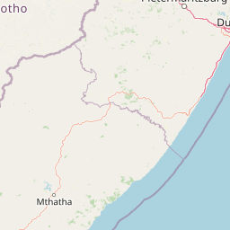
Map view of Lake Letsie

Use this park location map to pinpoint Lake Letsie in Lesotho, understand its exact geographic position, and read its mapped placement within the surrounding landscape more clearly.

Pigeon | © OpenStreetMap contributors

Location context for Lake Letsie

Quthing District
Park atlas

Compare adjacent highland wetlands and mountain reserves across surrounding terrain.

Explore Protected Areas and Parks Near Lake Letsie in the Drakensberg Region

Browse other parks near Lake Letsie to examine related highland wetlands and protected landscapes across the high Drakensberg escarpment. Extending geographical comparison helps place local conservation zones within a broader regional park network.
National parkEastern Cape
About 11 km away#1 closest

South

Grassland National Park National Park: Exploring Protected Landscapes and Regional Geography

Mapped boundaries and natural terrain context for an Eastern Cape protected area.

Grassland National Park represents a crucial protected area within South Africa's Eastern Cape province. As a national park, it offers significant insights into the region's natural landscapes and geographic character. This atlas perspective focuses on understanding the park's mapped scope, its terrain features, and its place within the broader provincial geography. Discover the unique protected landscape identity of Grassland National Park and how it contributes to the mapped natural heritage of the Eastern Cape.

Area
102.25 km²
Established
2025
IUCN
II
Relief
Mountain
National parkQacha's Nek District
About 97 km away#2 closest

Northeast

Sehlabathebe National Park: Mapped Protected Landscape in Lesotho's Maloti Mountains

Explore high-altitude terrain, waterfalls, and ancient rock art sites.

Sehlabathebe National Park stands as a protected national park within the rugged Maloti Mountains of Lesotho's Qacha's Nek District. This destination is vital for understanding the geographic context of protected areas, featuring dramatic cliffs, iconic waterfalls like Tsoelikana, and numerous rock art sites that speak to its cultural and historical significance. Its high-altitude Afro-Alpine and sub-alpine ecosystems offer unique landscape characteristics and support notable biodiversity, making it a key point of interest for atlas-driven exploration of natural and protected terrains.

Area
69.5 km²
Established
1969
IUCN
IV
Relief
Mountain
A watercolor illustration featuring soft, green rolling hills in the foreground with pale, layered mountain peaks in the background, set against a plain white field.
Protected areaKwaZulu-Natal
About 104 km away#3 closest

Northeast

Maloti-Drakensberg Park Geography: Mountain Escarpments and Alpine Plateau Exploration

A transboundary protected landscape spanning South Africa and Lesotho

Spanning the core of the Drakensberg mountain system, Maloti-Drakensberg Park provides a unique window into high-altitude biodiversity and geological drama. The protected area features basalt cliffs, rolling valleys, and an extensive plateau, forming a critical ecological and cultural corridor. This atlas entry covers the topographic features and spatial distribution of one of southern Africa's most significant protected landscapes.

Area
2,493.13 km²
Established
2001
Relief
Mountain
Climate
Alpine
Protected areaKwaZulu-Natal
About 104 km away#4 closest

Northeast

uKhahlamba-Drakensberg Park: Protected Mountain Landscapes and Escarpment Geography in South Africa

Exploring the basalt cliffs and alpine plateau of KwaZulu-Natal.

uKhahlamba-Drakensberg Park encompasses an expansive protected region where the Drakensberg escarpment rises sharply from the foothills of KwaZulu-Natal. This atlas record details the park landscape, including its transition from sandstone terraces to high-altitude basalt, its extensive river gorges, and the concentration of archaeological cave sites. Use this resource to understand the geographic scale of this transboundary conservation area.

Area
2,429.13 km²
Relief
Mountain
Climate
Temperate
Access
Access unknown
Natural monumentMaseru District
About 117 km away#5 closest

Northwest

Thaba Bosiu Natural Monument: Mapping the Plateau Geography in Maseru District

A fortified sandstone landscape with deep cultural roots

Thaba Bosiu remains one of the most recognizable geographic landmarks in Lesotho, featuring a flat-topped sandstone summit surrounded by sheer cliffs. This natural monument provides a unique window into the regional terrain, tracing the intersection of river valley systems, basalt formations, and historical mountain refuge sites that define the Maseru District.

Area
2 km²
Established
1967
Relief
Mountain
Access
Easy access
Nature reserveKwaZulu-Natal
About 119 km away#6 closest

East

Ntsikeni Nature Reserve: High-Elevation Wetland Geography and Protected Landscape Atlas

A remote Drakensberg foothills wetland and montane grassland reserve.

Ntsikeni Nature Reserve is recognized as the largest and one of the highest wetlands in South Africa. Located in the KwaZulu-Natal province, this protected area features a unique, misty plateau landscape that sustains diverse orchid flora and essential headwater ecosystems. Use these geographic maps to examine the terrain, park boundaries, and the ecological transition between rolling foothills and the Drakensberg escarpment.

Area
92.87 km²
Established
1978
Relief
Upland
Climate
Temperate
Nature reserveKwaZulu-Natal
About 122 km away#7 closest

East

Mount Currie Nature Reserve: A Detailed Geographic Atlas of KwaZulu-Natal Mountains

High-altitude wetlands and protected Drakensberg foothills

Mount Currie Nature Reserve encompasses a rugged expanse of Drakensberg foothills characterized by sharp dolerite cliffs and expansive central wetland systems. This protected area acts as a crucial ecological intersection, bridging montane grassland and Afromontane forest patches while providing a sanctuary for diverse avian life and significant cultural heritage sites.

Area
17.77 km²
Established
1980
IUCN
IV
Relief
Mountain
Nature reserveKwaZulu-Natal
About 129 km away#8 closest

East

Coleford Nature Reserve: Protected Grasslands and Wetlands in KwaZulu-Natal

Tracing the landscape of a key Drakensberg foothill reserve

The Coleford Nature Reserve represents a critical protected area in the Southern Drakensberg, featuring threatened Drakensberg Foothill Moist Grassland. Its landscape is defined by the Ngwagwane River valley and diverse wetland systems, providing essential habitat for endangered bird species. This reserve functions as a gateway to the broader montane geography of the southwestern KwaZulu-Natal region.

Area
12.72 km²
Established
1948
IUCN
IV
Relief
Highland

Common questions about visiting, size, designation, and location context for Lake Letsie

Lake Letsie FAQs for park facts, access, geography, and protected area context

Find quick answers about Lake Letsie, including protected-area facts, park geography, trail and visitor context, and how the park fits into its surrounding country and regional landscape.
MoriAtlas Explorer

Continue Your Protected Areas Search Across the Global Atlas

Deepen your exploration by continuing the structured search for national parks and protected areas worldwide. Utilize the comprehensive filtering capabilities to compare different conservation landscapes and refine your understanding of global park geography. Discover more about the distribution and characteristics of protected natural areas.

Global natural geography