Mori Atlas logo
Nature reserveŁąki Ciebłowickie

Mapping the protected meadow mosaics, riparian forest remnants, and riverine hydrology

Łąki Ciebłowickie Nature Reserve: A Detailed Atlas of Central Poland's Floodplain Geography

The Łąki Ciebłowickie protected area occupies a significant segment of the Pilica river floodplain in central Poland. This nature reserve serves as an essential ecological mosaic comprising diverse riparian habitats including oxbow lakes, wet meadows, and gallery forests. By examining the local terrain, the site illustrates the complex relationship between natural river dynamics and the sustained management of lowland protected landscapes within the Lodzkie Voivodeship.

Łąki CiebłowickieNatura 2000Special Area of ConservationPolandCentral PolandŁódzkie Voivodeship

Łąki Ciebłowickie

Nature reserve

Park overview

Structured park overview, official facts, and landscape profile for Łąki Ciebłowickie

Łąki Ciebłowickie park facts, protected area profile, and essential visitor context

Review the core facts for Łąki Ciebłowickie, including designation, size, terrain, visitor scale, habitats, and operating context in one park-focused overview.

About Łąki Ciebłowickie

Łąki Ciebłowickie is a Natura 2000 Special Area of Conservation in central Poland, focused on the protection of wetland communities along a lowland river floodplain. The designation brings together several habitat types that are typically found as scattered fragments across the Polish countryside, making the site a representative example of the habitat diversity still surviving along certain stretches of central Polish river valleys. Its inclusion in the Natura 2000 network reflects the broader European effort to maintain coherent networks of natural and semi-natural habitats across member states.

The site's structure reflects the classic zonation of a temperate lowland river floodplain. Nearer the active channel and former channels, natural oxbow lakes and eutrophic water bodies create still-water habitats, while riparian willow, poplar, and alder forests line the wetter ground. Slightly elevated terraces support oak-hornbeam woodland in the form of grąd communities, while the transition between forest and water is marked by meadows that have traditionally been used in an extensive way. This layering of habitats in close proximity is one of the defining features of Łąki Ciebłowickie and explains why so many species of conservation interest can be supported within a relatively compact area.

From a conservation perspective, the site is significant because it protects habitat types that have been heavily reduced elsewhere in lowland Europe. Intensively used agricultural land and river regulation have eliminated or fragmented many of these floodplain communities across central Europe, leaving surviving sites like Łąki Ciebłowickie especially important as refuges for both habitats and the wildlife depending on them. The combination of protected habitat types and protected animal species underlines the site's role within the central Polish ecological network.

The site also illustrates how Polish Natura 2000 areas often exist in a working landscape rather than as untouched wilderness. Meadows that are still occasionally mown or grazed, forests that continue their natural regeneration, and a river system that retains elements of its natural hydrology all contribute to the conservation value of Łąki Ciebłowickie, alongside formal protection status.

Quick facts and research context for Łąki Ciebłowickie

Łąki Ciebłowickie (Natura 2000 code PLH100035) is a Special Area of Conservation located in the Łódzkie Voivodeship of central Poland, within Tomaszów county near the commune of Lubochnia. The site covers approximately 477 hectares and is centered on floodplain habitats shaped by the Pilica river system. Its designation focuses on the conservation of natural habitat types listed under the EU Habitats Directive, including natural eutrophic water bodies, traditional meadows, gallery forests, and oak-hornbeam woodland communities. The site also provides protection for several animal species, including the European beaver, the large copper butterfly, the fire-bellied toad, the bitterling fish, the crested newt, the green snaketail dragonfly, and the Eurasian otter.

Protection and recognition

Documented terrestrial protection metrics and official international recognition records

Łąki Ciebłowickie Protection Status and Natura 2000 Recognition Details

Terrestrial protection status for Łąki Ciebłowickie includes documented Natura 2000 recognition records governing the conservation landscape. Official designation details and designated management scope provide verified baseline facts for international review.

International recognition

Protection details

Protection scope
Terrestrial
Transboundary protection
No
Park context

Deeper park guide and search-rich context for Łąki Ciebłowickie

Łąki Ciebłowickie history, landscape, wildlife, and travel context

Explore Łąki Ciebłowickie through its history, landscape character, ecosystems, wildlife, conservation priorities, cultural context, and seasonal travel timing in a structured park guide built for atlas discovery and search intent.

Why Łąki Ciebłowickie stands out

Łąki Ciebłowickie is best known as a lowland floodplain nature area that combines wet meadows, oxbow lakes, riparian willow and alder forests, and patches of oak-hornbeam woodland. Its ecological signature is shaped by the interaction of river flooding, traditional grassland management, and surviving gallery forest fragments. These patterns create the habitat mosaic that allows it to support a surprising diversity of wetland, amphibian, fish, and invertebrate species for an area of its size in central Poland. The site is particularly notable for the concentration of protected habitat types in a small geographic footprint. A single floodplain area here can simultaneously hold oxbow water bodies, montane-style tall herb fringes, extensively used meadows, central European oak-hornbeam forest, and willow-poplar floodplain forest, an unusual combination even within the broader Polish Natura 2000 network.

Łąki Ciebłowickie landscape and geographic character

The landscape of Łąki Ciebłowickie is defined by the gentle topography of a central Polish river floodplain. The terrain is mostly flat to gently undulating, shaped over thousands of years by the migration, flooding, and deposition of the river that flows through the area. Former river channels, now cut off from the main stream, form oxbow lakes and shallow still-water basins that are typical features of lowland river valleys in this part of Europe.

A particularly distinctive element of the landscape is the alternation between wet, low-lying areas near the former and active channels, slightly higher ground supporting oak-hornbeam woodland, and open meadow areas on the transitional slopes. This mosaic reflects the natural gradient between water, floodplain forest, and grassland, and gives the site its characteristic layered appearance.

The visual impression is one of quiet, low-scale scenery rather than dramatic landforms. Willow and alder stands line the wetter ground, while taller oak-hornbeam woodland rises on slightly elevated terraces. Between these forested zones, the meadows provide open vistas that change with the seasons, from spring greening to summer flowering and late-season hay coloring.

Łąki Ciebłowickie ecosystems, habitats, and plant life

Łąki Ciebłowickie protects a rich mosaic of wetland and woodland habitats typical of central European lowland river valleys. Among the most important habitat types are natural eutrophic water bodies with floating and submerged vegetation communities, including old oxbow channels with characteristic water plant assemblages. These still waters are key habitats for several of the site's protected animal species.

Riverbank and floodplain forests form another major component of the site's ecology. Willow, poplar, and alder galleries line the wetter ground and are typical of the softwood floodplain forests that have become increasingly rare across lowland Europe. On slightly higher ground, the site includes oak-hornbeam (grąd) communities, which represent a more mature type of deciduous forest with a developed understory and high biodiversity value.

Extensively used meadows are another defining habitat. They form part of the network of lowland grasslands that have been shaped by long-term traditional management and that retain a much richer flora than intensively cultivated farmland. Tall herb fringes along the edges of forests and water bodies create further habitat variety and support pollinator and invertebrate communities.

Łąki Ciebłowickie wildlife and species highlights

The wildlife of Łąki Ciebłowickie is closely tied to the wetland character of the floodplain. The site supports the European beaver, a species whose recovery in central Poland has been closely linked to the availability of suitable river and floodplain habitat. Beaver activity contributes to the maintenance of the wetland mosaic that the site is designed to protect.

Wetland and aquatic species are particularly well represented. The fire-bellied toad and the crested newt use the still-water habitats such as oxbows and small ponds for breeding, while the bitterling, a small freshwater fish, depends on the presence of mussels in clean lowland waters. The green snaketail, a dragonfly associated with flowing and well-oxygenated lowland rivers, reflects the continuing ecological quality of the river system.

The large copper butterfly, a butterfly of wet meadows and marshy places, uses the open meadow habitats as part of its life cycle. The Eurasian otter, a wider-ranging mammal associated with clean water systems and intact riparian habitat, is also among the protected species for which the site has been designated. Together, these species illustrate how the site's conservation significance spans mammals, amphibians, fish, invertebrates, and reptiles across very different parts of the food web.

Łąki Ciebłowickie conservation status and protection priorities

Łąki Ciebłowickie is protected as a Natura 2000 Special Area of Conservation, with the official code PLH100035, under the European Union Habitats Directive. Its designation recognizes that the area holds habitat types and species of community-level importance that require long-term safeguarding. The site's conservation value is enhanced by the fact that several of its protected habitats, including softwood floodplain forests, oak-hornbeam woodland, and extensively managed meadows, have declined substantially across lowland Europe due to drainage, agricultural intensification, and river modification.

The site's inclusion in the Natura 2000 network is intended to ensure that damaging activities that could significantly affect the protected habitats or species are assessed and, where necessary, avoided or mitigated. By integrating Łąki Ciebłowickie into the wider central Polish network of protected sites, the designation contributes to habitat connectivity across the country and across the European Union.

At a broader scale, Łąki Ciebłowickie plays a role in maintaining ecological coherence within lowland river valleys where natural floodplain dynamics have been substantially altered by human activity. Even relatively small floodplain sites like this one can act as key refuges for species that depend on the specific combination of open water, riparian forest, and wet meadow habitats that still survive here.

Top sights and standout views in Łąki Ciebłowickie

Łąki Ciebłowickie stands out for packing an unusually complete floodplain habitat sequence into a relatively small area of central Poland. Within a single landscape, visitors can encounter oxbow lakes, still-water plant communities, willow-poplar floodplain forests, oak-hornbeam woodland, and traditionally managed meadows, all part of the formal Natura 2000 designation.

Another notable aspect of the site is the diversity of protected animal species associated with it. Beavers, otters, fire-bellied toads, crested newts, bitterling fish, dragonflies, and rare butterflies all share the same floodplain mosaic. This breadth of protected fauna across mammals, amphibians, fish, and invertebrates highlights how interconnected the site's habitats truly are.

Best time to visit Łąki Ciebłowickie

The most rewarding period to experience Łąki Ciebłowickie depends on what kind of landscape one most enjoys. Late spring and early summer are typically the most colorful and biologically active season, when meadows are in flower, aquatic vegetation in oxbows is at its peak, and many insects, amphibians, and dragonflies are most visible.

Autumn brings softer light, warm meadow colors after mowing, and the chance to see woodland inhabitants more easily as leaves thin out, while winter can offer a clearer view of the underlying floodplain structure, with oxbows, channels, and forest patches becoming more visible without dense vegetation. Any visit benefits from quiet observation rather than active infrastructure, since the site's value lies in its natural character and the continuity of its floodplain habitats.

Monthly climate preview

Long-term representative point measurements tracking monthly temperature and precipitation rhythm

Łąki Ciebłowickie Climate Normals, Annual Temperature and Precipitation Patterns

Representative coordinates record mean monthly temperatures shifting from sub-zero winter minimums to warm summer maximums alongside measured daily precipitation rates. Examining the full twelve-month profile details complete seasonal climate normals for Łąki Ciebłowickie.
Annual mean8 °C
-3 °C20 °C
Jan-3°
Feb-2°
Mar
Apr
May14°
Jun18°
Jul20°
Aug20°
Sep14°
Oct
Nov
Dec-2°
Warmest month
July

20.2 °C

Coolest month
January

-3.4 °C

Wettest month
July

2.7 mm/day

Driest month
January

1.3 mm/day

Park location guide

Geography guide, regional context, and park location map for Łąki Ciebłowickie

Łąki Ciebłowickie park geography, regions, and map view in Poland

Understand where Łąki Ciebłowickie sits in Poland through a broader geographic reading of the surrounding landscape, nearby location context, and its mapped position within the national park landscape.

How Łąki Ciebłowickie fits into Poland

Poland, officially the Republic of Poland, is a Central European country spanning from the Baltic Sea in the north to the Carpathian Mountains in the south. It borders Germany, Czech Republic, Slovakia, Ukraine, Belarus, Lithuania, and Kaliningrad Oblast. The country has a temperate climate, diverse landscapes, and is known for its rich history, cultural heritage, and strong economic position within the EU.

Wider geography shaping Łąki Ciebłowickie in Poland

Poland occupies 312,696 km2 in Central Europe, extending from the Baltic Sea coast in the north to the Sudetes and Carpathian Mountains in the south. It borders Germany to the west, Czech Republic and Slovakia to the south, Ukraine and Belarus to the east, and Lithuania and Kaliningrad Oblast to the northeast. The landscape includes lowland plains, uplands, and mountain ranges.

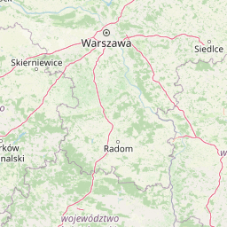
Map view of Łąki Ciebłowickie

Use this park location map to pinpoint Łąki Ciebłowickie in Poland, understand its exact geographic position, and read its mapped placement within the surrounding landscape more clearly.

Pigeon | © OpenStreetMap contributors

Location context for Łąki Ciebłowickie

Lodzkie Voivodeship
Recorded earthquake history

Explore the Historical Earthquake Archive for Łąki Ciebłowickie

Review the documented seismic history associated with the protected landscape of Łąki Ciebłowickie. This MoriAtlas collection presents historical event data for geographic context, allowing users to analyze recorded epicentres and seismic proximity within the regional framework.

Łąki Ciebłowickie Earthquake Records

Catalogued events

14 events

Strongest magnitude

Magnitude 3.2

Most recent event

Nov 10, 1992

This history includes earthquakes recorded inside the park or within 50 km of its borders

Park atlas

Compare regional lowland landscapes and connected river valley habitats

Explore Other Parks Near Łąki Ciebłowickie and Surrounding Protected Areas

Discover related protected areas and wetland reserves situated within the wider Pilica river region. Comparing adjacent lowland habitats helps trace ecological connectivity across central European river basins.
National parkMasovian Voivodeship
6 km away#1 closest

North

Kampinos National Park: Geographic Profile and Protected Forest Landscape Map

Inland dune formations and wetland habitats in Masovian Voivodeship

The expansive woodland of Kampinos National Park represents a critical protected area in Poland, characterized by its parabolic sand dunes and low-lying marshes. Gain insights into the geomorphological features of this UNESCO biosphere reserve and trace the complex hydrological network that defines its unique forest environment.

Area
385.44 km²
Established
1959
IUCN
II
Relief
Lowland
A soft watercolor illustration of a marshy landscape with low rolling hills, scattered trees, and a winding stream, rendered in light green and yellow tones on a white background.
National parkMasovian Voivodeship
6 km away#2 closest

North

Kampinoski Park Narodowy: Mapping the Inland Dune and Wetland Landscapes of Central Poland

A vital protected area in Masovian Voivodeship

The landscape of Kampinoski Park Narodowy is defined by the Grochalskie Piachy dune complex and diverse riparian habitats. This atlas entry covers the geological history and protected boundaries of this significant lowland forest, tracing the Vistula river valley's influence on the surrounding terrain and ecological character.

Area
385.443 km²
Established
1959
Visitors
1M annual
Relief
Lowland
Protected landscapeLodzkie Voivodeship
7.8 km away#3 closest

Southwest

Sulejowski Park Krajobrazowy: Geography and Protected Landscape Mapping

Central Polish river valley and reservoir terrain

Examine the territorial boundaries and landscape character of Sulejowski Park Krajobrazowy. This protected area integrates riverine corridors, large reservoir habitats, and mixed lowland forests across the Lodzkie Voivodeship, providing a core reference for understanding the ecological geography of the central Pilica valley.

Area
170.26 km²
Established
1994
Relief
Lowland
Climate
Temperate
Nature reserveŁódź Voivodeship
About 9.8 km away#4 closest

Northwest

Rezerwat przyrody Małecz: Protected Nature Reserve and Forest Landscape in Łódź Voivodeship

Floristic reserve and managed coniferous forest geography

Rezerwat przyrody Małecz is a key floristic site in Poland, safeguarding rare Pontic-origin flora and ancient forest stands. This reserve showcases the integration of strict protection zones with moist and dry mixed coniferous forest communities within the Spała Forest District, offering deep insight into regional botanical conservation.

Area
0.092 km²
Established
1987
Relief
Lowland
Climate
Temperate
Nature reserveLodzkie Voivodeship
About 22 km away#5 closest

Southwest

Rezerwat przyrody Meszcze Nature Reserve: Mapped Protected Landscape and Forest Ecology

Protected fresh mixed forest within the Sulejów Landscape Park context

Rezerwat przyrody Meszcze represents a compact, protected forest block in central Poland. Known for its historical small-leaved lime regeneration, this reserve provides a key case study for forest structure and lowland biodiversity within the Lodzkie Voivodeship, serving as an important part of the Sulejów Landscape Park's protected corridor.

Area
0.353 km²
Established
1959
Relief
Lowland
Scope
Terrestrial
Nature reserveŁódź Voivodeship
About 24 km away#6 closest

West

Rezerwat przyrody Dęby w Meszczach: Protected Oak Forest and Regional Geography

Nature reserve in the Równina Piotrkowska of central Poland.

Located in Łódź Voivodeship, this nature reserve is defined by its ancient pedunculate oaks, some over 250 years old. The site protects a unique blend of oak-hornbeam and mixed coniferous forest communities, serving as an ecologically vital fragment of lowland woodland within an agricultural landscape.

Area
0.392 km²
Established
1989
Relief
Lowland
Climate
Temperate
Nature reserveLodzkie Voivodeship
About 35 km away#7 closest

South

Jodły Sieleckie Nature Reserve: Geographic Insights and Protected Area Mapping

Woodland conservation in the Łódź Voivodeship

Analyze the protected boundaries and landscape context of Jodły Sieleckie Nature Reserve, a woodland habitat defined by its natural fir regeneration. This site within the Wzgórza Opoczyńskie mesoregion provides a clear look at how forest ecology and remnants of historical mining activity intersect within the central Polish landscape.

Area
0.327 km²
Established
1998
Relief
Upland
Scope
Terrestrial
Nature reserveLodzkie Voivodeship
About 35 km away#8 closest

Northwest

Doliska Nature Reserve: Protected Forest Boundaries and Geographic Landscape Context in Poland

A study in regional forest conservation and woodland ecology

Located in the Lodzkie Voivodeship, Doliska Nature Reserve is a designated phytocenotic forest area established to preserve specific woodland communities. Its primary geographic value lies in the protection of silver fir populations that exist outside their natural distribution range, making this a foundational site for regional conservation history and ecological study in the heart of lowland Poland.

Area
0.033 km²
Established
1954
Relief
Upland
Scope
Terrestrial

Common questions about visiting, size, designation, and location context for Łąki Ciebłowickie

Łąki Ciebłowickie FAQs for park facts, access, geography, and protected area context

Find quick answers about Łąki Ciebłowickie, including protected-area facts, park geography, trail and visitor context, and how the park fits into its surrounding country and regional landscape.
MoriAtlas Explorer

Continue Your Protected Areas Search Across the Global Atlas

Deepen your exploration by continuing the structured search for national parks and protected areas worldwide. Utilize the comprehensive filtering capabilities to compare different conservation landscapes and refine your understanding of global park geography. Discover more about the distribution and characteristics of protected natural areas.

Global natural geography