
Mori Atlas logo
Marine protected areaLamlash

Mapping the protected waters and maritime terrain of the Isle of Arran coastline

Lamlash Marine Protected Area: A Coastal Sanctuary and Geographic Landmark in Scotland

Lamlash Bay stands as a vital marine protected landscape on the eastern shore of the Isle of Arran in Scotland. This coastal site encompasses a pioneering No Take Zone, safeguarding delicate maerl seaweed beds and diverse underwater habitats within a naturally sheltered harbour. Its unique geography, defined by the interplay between Arran's rugged slopes and the profile of Holy Isle, creates a significant area for ecological study and coastal conservation.

Firth of ClydeIsle of Arrancoastal baymarine protected areaNo Take Zonemaerl beds
A flat-style digital illustration depicting a valley with steep, colorful rock formations, a waterfall in the midground, a river flowing through the center, and evergreen trees in the foreground.

Lamlash

Marine protected area

Park overview

Structured park overview, official facts, and landscape profile for Lamlash Bay

Lamlash Bay park facts, protected area profile, and essential visitor context

Review the core facts for Lamlash Bay, including designation, size, terrain, visitor scale, habitats, and operating context in one park-focused overview.

About Lamlash Bay

Lamlash Bay is a sheltered coastal inlet on the Isle of Arran, on the eastern side of the island facing north-eastward into the Firth of Clyde. The bay sits between the Lamlash seafront on the Arran mainland and the steep slopes of Holy Isle, which rises offshore as a distinctive landmark. The village of Lamlash lines the inland side of the shore road, with two- and three-storey roughcast and stone houses, parish churches at either end of the settlement, and the nineteenth-century Hamilton Terrace cottages on the seafront defining the visual character of the bay.

The bay's protective setting has shaped its history and identity for centuries. Glasgow's Department of Naval Architecture and Marine Engineering has described Lamlash Bay as a good natural harbour offering very good shelter, and it has historically been used by the Royal Navy Home Fleet and Atlantic Fleet. A community of fishermen, ferry operators, and an RNLI lifeboat station continue to make the modern waters active, with summer passenger ferries regularly crossing to Holy Isle. The bay itself remains a focal coastal landscape for Arran residents, visitors, and marine researchers alike.

What distinguishes Lamlash Bay ecologically is its protected marine status. A No Take Zone in the northern part of the bay has prohibited all commercial and recreational fishing since 2008, with the explicit aim of conserving maerl seaweed beds and supporting broader marine regeneration. The designation grew out of a long community campaign by C.O.A.S.T. and was followed by recognition of the wider sea around southern Arran, including Lamlash waters, as part of Scotland's network of Mature Conservation Marine Protected Areas. As a result, the bay now combines cultural, historical, and ecological significance within a single coastal setting.

Quick facts and research context for Lamlash Bay

Lamlash Bay lies on the eastern coast of the Isle of Arran in North Ayrshire, Scotland, opening north-eastward into the Firth of Clyde across from Holy Isle. It is widely recognised by naval and marine engineering sources as a naturally sheltered harbour that has historically hosted Royal Navy fleets.

In September 2008, the northern part of the bay was designated a No Take Zone under the Inshore Fishing Order 2008, becoming Scotland's first statutory No Take Zone. The protection was driven by the Community of Arran Seabed Trust (C.O.A.S.T.) and represents the first time marine statutory protection in Scotland resulted from grassroots proposals. The wider marine area south of Lamlash forms part of Scotland's network of Mature Conservation Marine Protected Areas.

Protection and recognition

Examine the official marine protection scope, 2008 designation timeline, and documented conservation context.

Lamlash Protection Status and Marine Designated Area History

Marine protection status for Lamlash encompasses structured designation records established in 2008 within the regional marine conservation framework. Documented recognition history provides verified administrative context for evaluating the scope and framework of this protected coastal territory.

Protection details

Protection scope
Marine
Designated year
2008
Transboundary protection
No
Park context

Deeper park guide and search-rich context for Lamlash Bay

Lamlash Bay history, landscape, wildlife, and travel context

Explore Lamlash Bay through its history, landscape character, ecosystems, wildlife, conservation priorities, cultural context, and seasonal travel timing in a structured park guide built for atlas discovery and search intent.

Why Lamlash Bay stands out

Lamlash Bay is best known for being the location of Scotland's first No Take Zone, established in 2008 to protect maerl seaweed beds and allow marine life to recover. The bay is also recognised as a historic natural harbour, with documented capacity to shelter large naval fleets in the sheltered waters between Arran and Holy Isle. Together, these qualities give the bay a dual identity as an actively managed marine conservation site and a long-valued coastal refuge in the Firth of Clyde.
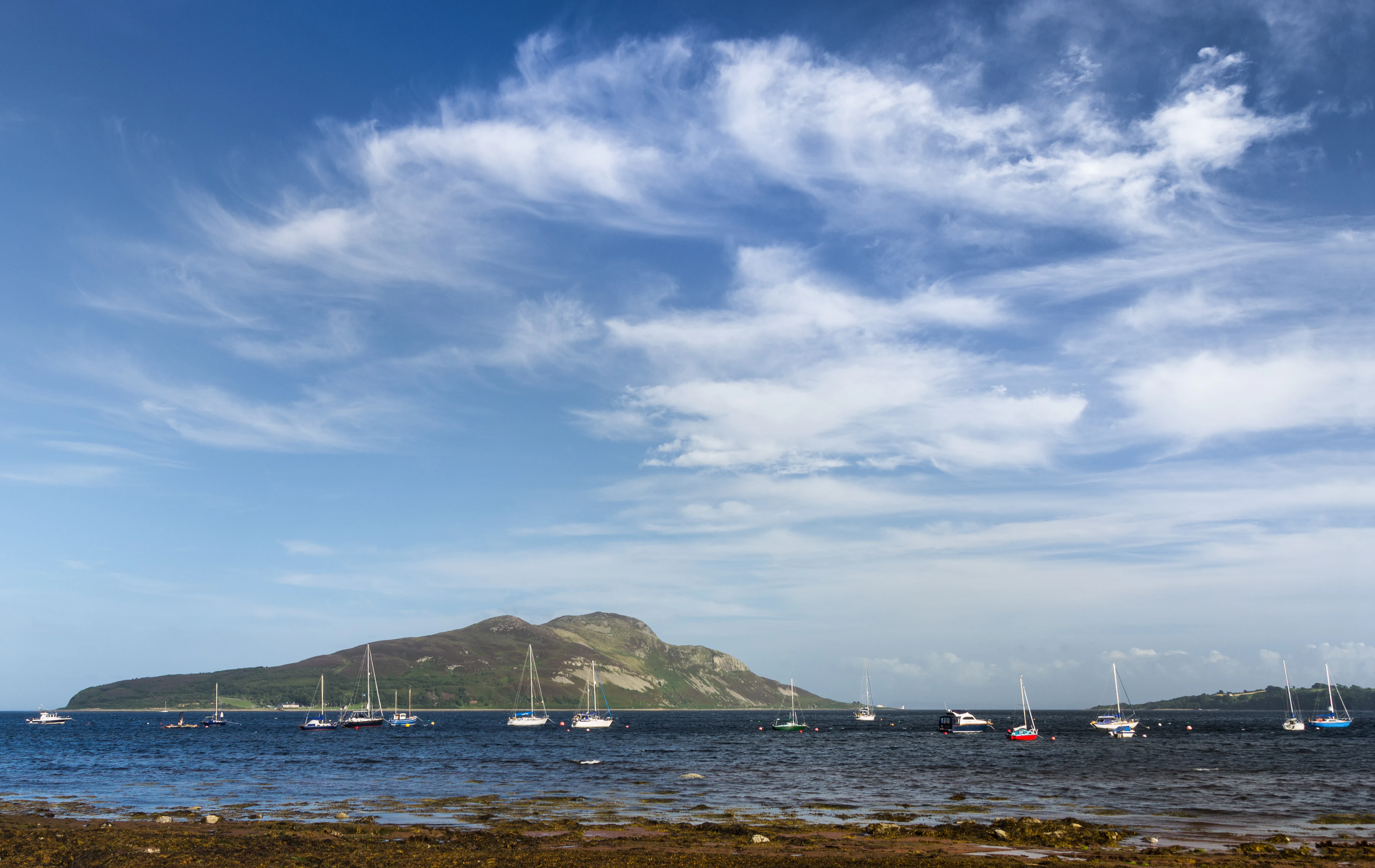
A wide view of a calm bay with numerous sailboats moored in the distance, framed by a large island hill and a bright blue sky with wispy clouds.
View of Holy Isle across the waters of Lamlash Bay.

Lamlash Bay history and protected-area timeline

The Lamlash Bay area has been inhabited since antiquity, with prehistoric stone rings near the village marking early settlement. The name Lamlash itself traces back to Saint Molaise, a sixth-century Celtic monk who lived in a cave on neighbouring Holy Isle around 590 AD; the Gaelic name for Holy Isle, Eilean MoLaise, gradually evolved through Elmolaise and Lemolash into the modern form.

The bay has repeatedly played a role in major historical events. It was peripherally involved in the 13th-century Battle of Largs, and in 1548, during the Rough Wooing, the English commander Grey of Wilton proposed basing warships at Lamlash to watch for French ships carrying the young Mary, Queen of Scots. Mary's ship later anchored in the roadstead of the isle of Lamlash before reaching France. The bay's sheltered waters continued to be used for military purposes in later centuries, including as a training ground for No. 11 (Scottish) Commando during the early years of the Second World War.

In the nineteenth century, the Lamlash shorefront was reshaped by Hamilton Terrace, designed by Sir John James Burnet, and the surrounding land was affected by the Highland Clearances; displaced Arran crofters famously departed from Lamlash for Canada from 1829 onwards, a story now commemorated by a standstone monument on the seafront lawn. In the modern era, the most significant chapter in the bay's history has been the 2008 establishment of Scotland's first No Take Zone in its northern waters, the result of a long grassroots campaign led by the Community of Arran Seabed Trust.

Lamlash Bay landscape and geographic character

Lamlash Bay is defined by its bowl-like shelter, bounded on one side by the curving eastern coastline of Arran and on the other by the rugged slopes of Holy Isle. The bay's shoreline at Lamlash is a long, gently curving seafront edged by a shore road, with the settlement rising behind it in terraces of roughcast and stone-built houses and church steeples.

On the inland side of the bay, the broader Arran terrain rises into the highland-influenced island interior, though from the bay itself the immediate frame is dominated by sea, shoreline, and the silhouette of Holy Isle. Whitewashed and stone-built landmarks, including Hamilton Terrace and the Clearance Monument, occupy the seafront lawn, while the southern stretch of the bay opens out toward the wider Firth of Clyde.

The waters of the bay form their own visual layer of the landscape. Sheltered from the open Firth, the surface is generally calm, and the underwater scenery of the No Take Zone includes maerl beds and other habitats that have begun to recover from past fishing pressure, making the bay a place where marine scenery is as much a part of the setting as the land views.

Lamlash Bay ecosystems, habitats, and plant life

The defining natural character of Lamlash Bay is marine rather than terrestrial, anchored by the maerl seaweed beds that the No Take Zone was established to protect. Maerl beds are slow-growing, calcareous red algae habitats that support a wide community of associated marine life and are recognised as a particularly sensitive and ecologically rich biotope in Scottish waters.

By removing fishing pressure from the northern part of the bay, the 2008 designation has created a refuge where marine life can regenerate and recover. Beyond the immediate maerl beds, the surrounding waters form habitat for a range of fish, invertebrates, and shellfish, with neighbouring areas used for limited scallop and prawn fishing. The wider marine area south of Arran, encompassing Lamlash Bay, is now recognised among Scotland's Mature Conservation Marine Protected Areas, underlining its ecological importance at a regional scale.

The fact that marine habitat protection here was initiated and pushed forward by a local community trust makes Lamlash Bay unusual within Scotland's conservation landscape. The site illustrates how grassroots stewardship can shape the ecological future of a small but ecologically significant sea area.

Lamlash Bay wildlife and species highlights

Wildlife in and around Lamlash Bay is principally marine, centred on the species and habitats associated with maerl beds and the broader Firth of Clyde ecosystem. The No Take Zone in the northern part of the bay has been established specifically to allow these communities to recover and to provide a refuge for marine biodiversity more broadly.

Beyond the protected waters, the wider marine environment around southern Arran supports commercially targeted species such as scallops and prawns, harvested in small numbers from neighbouring overspill areas. Seabirds typical of the Firth of Clyde feed in and around the bay, and the calmer inshore waters near the Lamlash shorefront are used by a range of fish and invertebrate life that benefit from the shelter the bay provides.

Holy Isle, which rises directly from the bay, adds a terrestrial and coastal wildlife dimension. Its slopes and shoreline contribute to the ecological mosaic visible from Lamlash, and the continuity between the bay's marine habitats and the island's land habitats reinforces the area's broader wildlife value.

Lamlash Bay conservation status and protection priorities

Lamlash Bay is one of the most significant small-scale marine conservation sites in Scotland. The Inshore Fishing Order 2008 created a No Take Zone in the northern part of the bay, prohibiting both commercial and recreational fishing across the entire water column and seabed. This was the first statutory No Take Zone established in Scotland and the first Marine Protected Area in Scotland to arise from a community-led, grassroots campaign rather than from top-down designation.

The conservation rationale centres on the protection of maerl seaweed beds, a priority biotope that supports a wide range of associated marine species, and on the broader goal of allowing marine life to regenerate within a fully protected area. Violations of the fishing prohibition can lead to unlimited fines on conviction on indictment, giving the zone meaningful legal weight. The remainder of the bay has been planned as a Fisheries Management Area focused on scallops, though implementation has lagged behind the original community expectations.

At a wider scale, the sea south of Arran, including Lamlash waters, is now recognised as a Mature Conservation Marine Protected Area within Scotland's national MPA network. Together, these designations place Lamlash Bay at the intersection of community-led conservation, statutory marine protection, and Scotland's evolving national framework for marine spatial planning.

Lamlash Bay cultural meaning and human context

Lamlash Bay's cultural context is bound up with centuries of maritime activity on the Firth of Clyde. The sheltered bay supported naval operations and was visited by major historical figures, including Mary, Queen of Scots, who anchored in the bay's roadstead in August 1548 during her crossing to France. The bay also served military purposes well into the twentieth century, including as a Second World War Commando training site.

The shoreline of Lamlash reflects this layered history architecturally. Hamilton Terrace, designed by Sir John James Burnet, defines much of the seafront, while the parish churches at either end of the settlement and the former St George's United Free Church illustrate the area's ecclesiastical heritage. The Clearance Monument on the seafront lawn commemorates Arran's nineteenth-century emigrants who departed for Canada from Lamlash, adding a Gaelic-emigrant dimension to the bay's cultural identity.

More recently, the bay has become a place where marine conservation and local community identity intersect. The grassroots campaign behind the No Take Zone, led by the Community of Arran Seabed Trust, has made the bay a symbol of community-driven stewardship in modern Scotland, blending traditional maritime culture with contemporary environmental activism.

Top sights and standout views in Lamlash Bay

Lamlash Bay's strongest highlights lie in the combination of natural shelter, historic maritime use, and pioneering marine protection. The bay's status as a naturally sheltered harbour, used historically by Royal Navy fleets, sets the stage for its modern role as a centre of community-led marine conservation.

The 2008 No Take Zone in the northern part of the bay is the bay's defining contemporary feature. It was the first statutory No Take Zone in Scotland, driven by the Community of Arran Seabed Trust, and protects maerl beds and broader marine biodiversity with enforceable legal penalties. The wider recognition of the surrounding sea as a Mature Conservation Marine Protected Area extends this significance at a national scale.

Beyond conservation, the bay is anchored visually and culturally by the Lamlash seafront, Hamilton Terrace, the Clearance Monument, and the ever-present backdrop of Holy Isle across the water. Together these elements make Lamlash Bay a layered site of ecological, historical, and community significance on the Isle of Arran.

Best time to visit Lamlash Bay

Lamlash Bay has a temperate maritime climate shaped by the Firth of Clyde, with mild conditions year-round and limited extremes of heat or cold. Late spring through early autumn generally offers the calmest sea conditions, the longest daylight hours, and active ferry services running between Lamlash and Holy Isle, making this the most rewarding window for appreciating both the sea and the surrounding landscapes.

Summer brings the busiest visitor atmosphere, with regular ferry crossings, RNLI activity in the bay, and the most favourable conditions for viewing Holy Isle and the wider Clyde seascape from the Lamlash seafront. Outside the summer months, the bay retains a quieter, more contemplative character, and the interplay of low winter light, sea mists, and the silhouette of Holy Isle gives the shoreline a distinctive seasonal mood that is valued by those interested in landscape and coastal scenery rather than recreation alone.

Monthly climate preview

Trace long-term representative temperature and monthly precipitation averages for Lamlash

Lamlash Climate Normals, Annual Temperature and Precipitation Rhythm

Representative coordinates record measured monthly temperature ranges and precipitation rates across a multi-year climatology period for Lamlash. Opening the full profile reveals complete monthly averages to support detailed regional climate comparison.
Annual mean9 °C
5 °C14 °C
Jan
Feb
Mar
Apr
May10°
Jun13°
Jul14°
Aug14°
Sep13°
Oct10°
Nov
Dec
Warmest month
August

14.3 °C

Coolest month
February

4.9 °C

Wettest month
November

4.5 mm/day

Driest month
May

2.5 mm/day

Park location guide

Geography guide, regional context, and park location map for Lamlash Bay

Lamlash Bay park geography, regions, and map view in United Kingdom

Understand where Lamlash Bay sits in United Kingdom through a broader geographic reading of the surrounding landscape, nearby location context, and its mapped position within the national park landscape.

How Lamlash Bay fits into United Kingdom

The United Kingdom is a parliamentary constitutional monarchy located in northwestern Europe, consisting of four constituent countries: England, Scotland, Wales, and Northern Ireland. As a major global power with over 69 million residents, it maintains significant international influence in politics, economics, and culture.

Wider geography shaping Lamlash Bay in United Kingdom

The United Kingdom is an island nation located in northwestern Europe, surrounded by the Atlantic Ocean, North Sea, English Channel, Celtic Sea, and Irish Sea. It shares a land border with the Republic of Ireland to the west. The territory includes the island of Great Britain, the northeastern portion of Ireland, and most of the smaller British Isles islands.

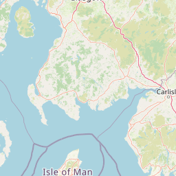
Map view of Lamlash Bay

Use this park location map to pinpoint Lamlash Bay in United Kingdom, understand its exact geographic position, and read its mapped placement within the surrounding landscape more clearly.

Pigeon | © OpenStreetMap contributors

Location context for Lamlash Bay

Scotland

Explore detailed photographs of shoreline terrain, marine habitats, and Holy Isle views across Lamlash.

Lamlash Photos and Coastal Scenery: Visualising the Protected Marine Landscape

Visual records capture the curving coastal topography, sheltered waters, and protected marine habitats defining Lamlash. Photographic documentation provides essential visual context for examining local terrain, conservation boundaries, and surrounding island scenery.

A wide view of a calm bay with numerous sailboats moored in the distance, framed by a large island hill and a bright blue sky with wispy clouds.

A wide shot looking across a blue bay towards a coastal village nestled between rolling green hills, with a mountain peak rising in the background under a clear sky.

Park atlas

Compare coastal landscapes and regional marine reserves across the Firth of Clyde

Explore Other Parks Near Lamlash and Surrounding Protected Areas

Browsing nearby national parks and protected areas allows visitors to compare the coastal terrain and marine conservation efforts of Lamlash with adjacent regional landscapes. Expanding the geographic scope reveals connected habitats and broader environmental networks throughout the surrounding Scottish coastline.
Watercolor illustration showing mountains, green forests, a loch, and a river in a landscape
National parkScotland
About 52 km away#1 closest

North

Loch Lomond and The Trossachs National Park: Mapped Landscapes and Terrain

Regional geography and protected Highland boundaries in Scotland

Loch Lomond and The Trossachs National Park covers a vast array of protected habitats, from coastal sea lochs to high-altitude Munros. This geographic profile outlines the park's position across the Highland Boundary Fault, highlighting its role as a core protected area for Caledonian forests and freshwater lake ecosystems within Scotland.

Area
1,865 km²
Established
2002
IUCN
V
Visitors
2.9M annual
A soft watercolor illustration depicting green rolling hills and a body of water in a minimalist style.
Marine protected areaArgyll and Bute
About 58 km away#2 closest

North

Loch Fyne Marine Protected Area and Highland Coastal Geography

Mapped sea loch landscapes in Argyll and Bute

Loch Fyne represents a unique intersection of maritime tradition and protected natural terrain. This entry maps the loch as it winds through the Cowal Peninsula, highlighting the contrast between northern mountain hinterlands and southern coastal inlets. Users can examine the extent of its protected waters, the surrounding topography, and its historical significance within the geography of western Scotland.

Established
2014
Relief
Mixed relief
Climate
Temperate
Access
Easy access
Marine protected areaArgyll and Bute
About 58 km away#3 closest

Northwest

Loch Sween Marine Protected Area: Coastal Geography and Regional Atlas Map

A distinctive sea loch ecosystem in Argyll and Bute.

Investigate the coastal topography and protected marine boundaries of Loch Sween. This sea loch is defined by its irregular branching inlets and islands, creating a unique habitat mosaic of maerl beds and burrowed mud within the broader context of the western Scottish coastline.

Area
41 km²
Established
2014
IUCN
IV
Access
Access unknown
A soft, artistic watercolor painting of a Scottish sea loch surrounded by gentle, green hills against a faint mountainous background.
Marine protected areaArgyll and Bute
About 68 km away#4 closest

North

Loch Goil Marine Protected Area: Geography and Landscape Overview

Protected marine habitats in the Argyll and Bute region

Loch Goil offers a distinct look at an enclosed, sea loch landscape in western Scotland. Surrounded by the Arrochar Alps and steep conifer slopes, this marine protected area demonstrates the intersection of Highland wilderness and formal conservation zones. Use this atlas resource to understand its topographical form and regional context.

Established
2014
Relief
Mountain
Climate
Temperate
Access
Moderate access
A soft watercolor painting of a landscape featuring green rolling hills, a suggestion of a reflective body of water, and layers of purple distant mountains against a light sky.
National parkScotland
About 68 km away#5 closest

Northeast

Loch Lomond and The Trossachs National Park: Geographic and Protected Area Overview

Tracing Highland and Lowland transition zones in Scotland

This protected area captures the contrast between the rugged mountainous terrain of the northern Trossachs and the gentler southern loch basins. By examining the Highland Boundary Fault, users can analyze how glaciers carved the landscape, creating the deep fjord-like trenches and islands that define the region's unique natural geography.

Area
71 km²
Established
2002
Relief
Mountain
Climate
Temperate
Protected landscapeArgyll and Bute
About 84 km away#6 closest

Northwest

Scarba, Lunga and the Garvellachs National Scenic Area: Protected Island Geography

Coastal landscapes and tidal seascapes of Argyll and Bute

Gain insight into the distinct protected landscape of the Scarba, Lunga and the Garvellachs National Scenic Area. This area balances mountainous moorland with green meadows, while its submerged marine reefs and fierce tidal waters contribute to a complex ecological and geographic identity within the Firth of Lorn.

Area
65 km²
Established
1981
Relief
Upland
Climate
Temperate
Protected areaCounty Antrim
About 88 km away#7 closest

Southwest

Slieveanorra Forest Protected Area: Geography, Maps, and Upland Landscape Context

A comprehensive look at the Antrim forest and glacial landscape.

Slieveanorra Forest serves as a prominent protected area within the County Antrim uplands. Featuring expansive conifer woodlands, the site includes rugged terrain, reservoir edges, and scenic summit views. Understand the geological and environmental composition of this working forest landscape through its mapped boundaries and regional context.

Relief
Upland
Water
Minor water
Protected areaCounty Antrim
About 92 km away#8 closest

West

Benbane Head Protected Area: Geographic Profile and Regional Landscape Mapping

Coastal terrain and protected boundaries in County Antrim

Examine the geographic characteristics of Benbane Head, a significant protected area located in County Antrim. This profile highlights the site's physical boundaries and its place within the regional landscape, providing essential mapping context for understanding Northern Ireland's diverse natural terrain and conservation geography.

Area
0.052 km²
Established
1953
Relief
Lowland
Climate
Temperate

Common questions about visiting, size, designation, and location context for Lamlash Bay

Lamlash Bay FAQs for park facts, access, geography, and protected area context

Find quick answers about Lamlash Bay, including protected-area facts, park geography, trail and visitor context, and how the park fits into its surrounding country and regional landscape.
MoriAtlas Explorer

Continue Your Protected Areas Search Across the Global Atlas

Deepen your exploration by continuing the structured search for national parks and protected areas worldwide. Utilize the comprehensive filtering capabilities to compare different conservation landscapes and refine your understanding of global park geography. Discover more about the distribution and characteristics of protected natural areas.

Global natural geography