
Mori Atlas logo
Nature reserveLande de la Flotte et du Cluzeau

Understanding the geological rarity and open heathland landscapes of the Limousin plateau

Lande de la Flotte et du Cluzeau: A Protected Serpentinite Heathland in Haute-Vienne, France

Lande de la Flotte et du Cluzeau stands as a vital protected area within the Haute-Vienne department, showcasing a distinctive heathland habitat rooted in rare serpentinite geology. Located near the Monts de Fayat, this reserve contrasts sharply with the surrounding agricultural mosaic of the Limousin plateau. The site offers a unique geographic window into the ophiolitic lithotectonic complexes that define this section of central-western France.

serpentinite heathlandNatura 2000 siteregional nature reserveheathland conservationLimousin plateaugeological outcrop
A digital illustration of a winding trail through a golden and light-colored heathland, with rolling hills and patches of trees in the background under a soft sunset sky.

Lande de la Flotte et du Cluzeau

Nature reserve

Park overview

Structured park overview, official facts, and landscape profile for Lande de la Flotte et du Cluzeau

Lande de la Flotte et du Cluzeau park facts, protected area profile, and essential visitor context

Review the core facts for Lande de la Flotte et du Cluzeau, including designation, size, terrain, visitor scale, habitats, and operating context in one park-focused overview.

About Lande de la Flotte et du Cluzeau

The Lande de la Flotte et du Cluzeau sits on the Limousin plateau in the heart of the Haute-Vienne department, at the foot of the Monts de Fayat. Covering 132 hectares between 370 and 470 meters of elevation, the reserve occupies a portion of the typical central-French upland landscape, a patchwork of pastures, small woodlands, and scattered villages, but the site itself looks distinctly different from everything around it. Its surface is dominated by low, sparse vegetation and exposed rocky ground, a result of the underlying serpentinite bedrock that makes the soil thin and chemically unusual.

The reserve straddles two communes, Château-Chervix and Meuzac, and is split in two by a road connecting Le Cluzeau to Magnac-Bourg. Despite the modest scale of the protected area, the site carries significant conservation weight. It is classified as a ZNIEFF for its ecological and geological interest, was officially designated as a regional nature reserve in 1993, and contributes to the broader Natura 2000 network of serpentine heaths and grasslands in southern Haute-Vienne. It belongs to a curated group of related reserves, alongside the Lande de Saint-Laurent and the Lande des Pierres du Mas, that together represent the regional stronghold of this distinctive habitat type.

What makes the Lande de la Flotte et du Cluzeau especially valuable is the way its geology and its maintenance regime reinforce each other. The serpentinite substrate naturally favors a short, dry-loving (xerophilic) plant community, and the continued grazing of sheep across the parcel keeps woody encroachment in check, preserving the open character of the heath. Without that combination, the site would gradually be reclaimed by the dense forest and farmland that surround it, erasing one of the most botanically unusual landscapes in the Limousin.

Quick facts and research context for Lande de la Flotte et du Cluzeau

The Lande de la Flotte et du Cluzeau is a 132-hectare regional nature reserve located in Haute-Vienne, in the Nouvelle-Aquitaine region of France. Established in 1993, it lies between roughly 370 and 470 meters of elevation on the Limousin plateau, near the villages of Château-Chervix and Meuzac.

The site is classified as a ZNIEFF (Zone Naturelle d'Intérêt Écologique, Faunistique et Floristique) and contributes to the Natura 2000 network of serpentine heaths in southern Haute-Vienne. Its protected status is tied primarily to its serpentinite geology, a rare metamorphic substrate in the region that supports an unusual, low-stature heathland vegetation.

Protection and recognition

Examine documented protected area records, administrative tracking, and registry metadata.

Protection Status and International Recognition for Lande de la Flotte et du Cluzeau

Lande de la Flotte et du Cluzeau holds formal entry within global protected area databases under identifier 147088. Scholars and researchers rely on these verified registry records to track conservation parameters and administrative baselines.

Protection details

WDPA ID
147088
Park context

Deeper park guide and search-rich context for Lande de la Flotte et du Cluzeau

Lande de la Flotte et du Cluzeau history, landscape, wildlife, and travel context

Explore Lande de la Flotte et du Cluzeau through its history, landscape character, ecosystems, wildlife, conservation priorities, cultural context, and seasonal travel timing in a structured park guide built for atlas discovery and search intent.

Why Lande de la Flotte et du Cluzeau stands out

The reserve is best known for its serpentinite outcrops, a rare type of metamorphic rock in the Limousin area, and for the specialized dry-land plant life that grows on these metal-rich soils. The low, open heath vegetation it produces is distinctly different from the surrounding pastures and small woods, making the site a textbook example of a serpentine heath in central France. It is also recognized as part of a network of related serpentine heaths in southern Haute-Vienne, including the nearby Lande de Saint-Laurent. Among its most emblematic species are ferns such as the Maranta cloak fern (Paragymnopteris marantae), which in Limousin grows almost exclusively on serpentinite, alongside protected heathers, carnations, and gentians.
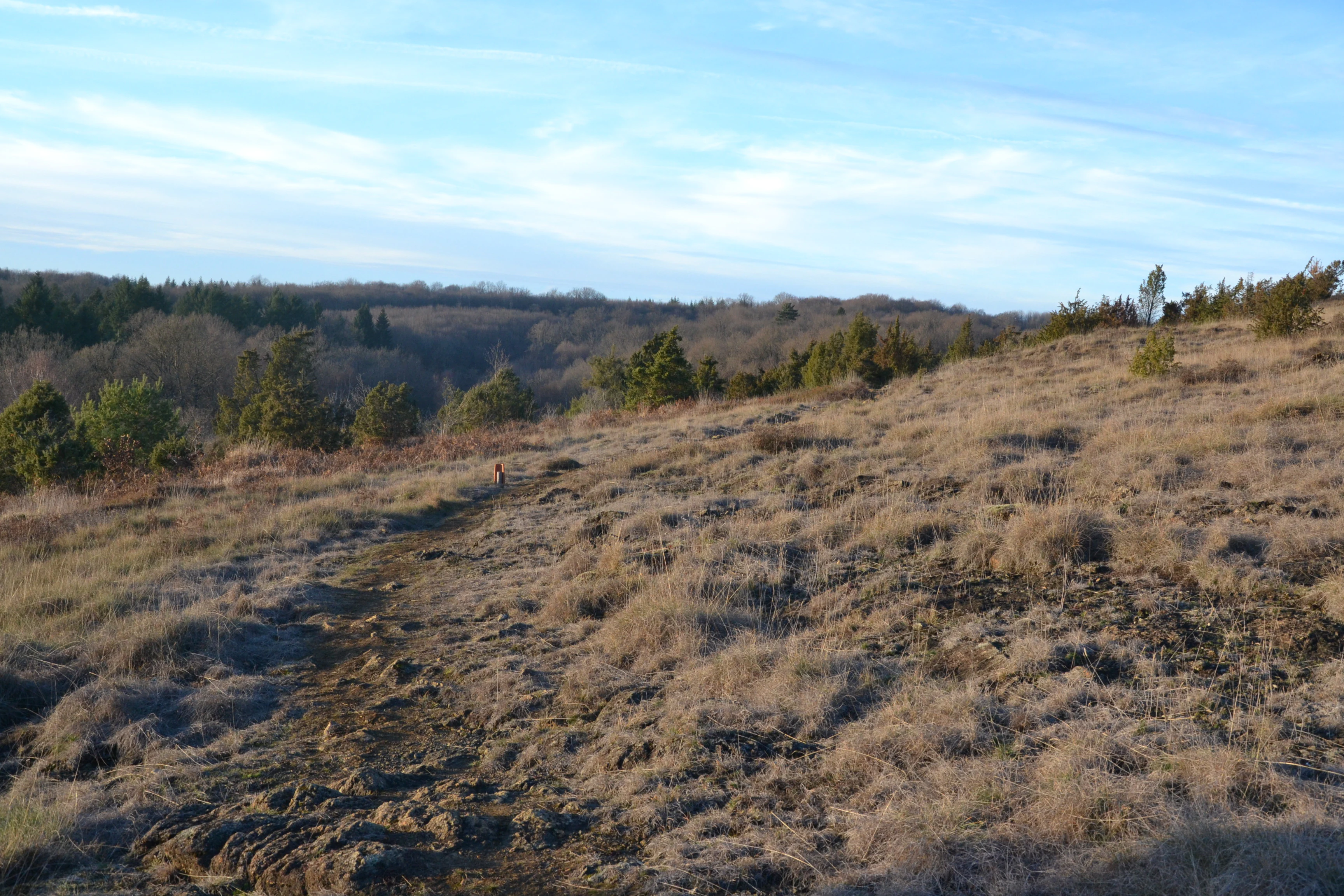
Wide view of a dry heathland slope with brown grasses, exposed rocky outcrops, and sparse evergreen trees under a blue sky.
Serpentinite heathland at Lande de la Flotte et du Cluzeau.

Lande de la Flotte et du Cluzeau history and protected-area timeline

The Lande de la Flotte et du Cluzeau received formal protected status in 1993 under France's regional nature reserve framework, acknowledging both its unusual serpentinite geology and the rare plant communities that depend on it. Its designation as a ZNIEFF predates that formal conservation step and reflects a longer recognition of its ecological distinctiveness at regional level.

Beyond its official history, the site has long depended on a traditional land management practice that shaped its current character: sheep grazing across the heath parcel keeps woody plants from taking over and helps preserve the low, open vegetation tied to its serpentine soils. That pastoral role remains central to how the reserve is maintained today.

Lande de la Flotte et du Cluzeau landscape and geographic character

The reserve lies in a rolling section of the Limousin plateau, at the foothills of the Monts de Fayat, between roughly 370 and 470 meters in elevation. From a distance, it blends into the wider upland mosaic of pastures and small woodlands typical of central-western France, but up close the landscape changes abruptly. The ground becomes rocky, and instead of fields or forest, the terrain is covered by low, sparse heath vegetation that sits directly on stony serpentinite slopes.

This contrast between the dense agricultural and forestry surroundings and the open, almost barren character of the reserve itself is the site's most immediate visual signature. It reflects an underlying ophiolitic geology, part of the metamorphic lithotectonic complex that surfaces in scattered points across southern Haute-Vienne, giving this part of the Limousin a quietly unusual geological identity.

Lande de la Flotte et du Cluzeau ecosystems, habitats, and plant life

The reserve's ecology is defined by its serpentinite soils, which are poor in nutrients and rich in heavy metals, and which naturally support a dry, open, low-stature plant community. This xerophilic heathland is the defining habitat of the site, and it is precisely this combination of substrate and open vegetation that the reserve is designed to protect.

The heath is shaped by both geology and management. The serpentinite keeps the soil thin and chemically challenging, naturally limiting the height and density of the vegetation, while grazing sheep prevent shrubs and trees from reclaiming the parcel. The result is an unusually open landscape in a region that is otherwise dominated by forest and farmland, and the plant communities that thrive here are directly tied to that combination of rocky soil and maintained openness.

Lande de la Flotte et du Cluzeau wildlife and species highlights

Wildlife observations on the reserve reflect its mix of open heathland and more humid microhabitats. Among the notable bird species recorded is the hen harrier (busard Saint-Martin), a raptor that depends on open landscapes and is often associated with low-intensity pastoral environments like this one.

Insects are also an important part of the site's fauna, especially in the wetter margins of the heath. Species such as the Mercury dragonfly (agrion de Mercure) and the marsh cricket (grillon des marais) have been documented here, signaling the presence of small, localized wetland or seepage conditions within an otherwise dry habitat. Their presence underlines the value of the site as a refuge for invertebrates that are sensitive to changes in land use and water quality.

Lande de la Flotte et du Cluzeau conservation status and protection priorities

The reserve's core conservation value lies in the geological and botanical rarity of serpentinite habitats in the Limousin region. Serpentinite outcrops are uncommon in central France, and the plant communities adapted to them, including specialized ferns, heathers, and other dry-loving species, are therefore both regionally and ecologically important. Protection at the site is aimed at preserving both the substrate itself and the delicate vegetation it supports.

Beyond the reserve boundaries, the Lande de la Flotte et du Cluzeau is part of a wider conservation network for serpentine heaths in southern Haute-Vienne. Together with the Lande de Saint-Laurent and the Lande des Pierres du Mas, it forms the backbone of the Natura 2000 listing for "serpentine heaths and grasslands of southern Haute-Vienne," giving the site a significance that extends well beyond its 132 hectares and ensuring that the conservation framework supporting it stretches across multiple connected parcels of similar habitat.

Top sights and standout views in Lande de la Flotte et du Cluzeau

The Lande de la Flotte et du Cluzeau protects one of the best examples of serpentine heathland in the Limousin, a habitat where unusual geology produces an unusually low and open plant community within an otherwise forested and farmed plateau landscape. Its serpentinite outcrops support plant species that are otherwise rare or absent from the region, including ferns and carnations that grow almost exclusively on this kind of rock in central France.

Equally important is the reserve's place within a wider conservation story: it anchors a network of protected serpentine heaths across southern Haute-Vienne, and its maintenance still depends on traditional sheep grazing, a quiet but essential link between the site's cultural landscape and its ecological future.

Monthly climate preview

Long-term representative monthly averages for temperature and precipitation

Lande de la Flotte et du Cluzeau Climate Normals and Temperature Rhythms

Representative coordinate measurements reveal the multi-year temperature and precipitation cycle spanning Lande de la Flotte et du Cluzeau. Examining the complete twelve-month normals profile provides deeper analytical context for regional meteorological patterns.
Annual mean11 °C
3 °C20 °C
Jan
Feb
Mar
Apr10°
May13°
Jun17°
Jul20°
Aug20°
Sep16°
Oct12°
Nov
Dec
Warmest month
August

20.4 °C

Coolest month
January

3.1 °C

Wettest month
November

3.1 mm/day

Driest month
July

1.8 mm/day

Park location guide

Geography guide, regional context, and park location map for Lande de la Flotte et du Cluzeau

Lande de la Flotte et du Cluzeau park geography, regions, and map view in France

Understand where Lande de la Flotte et du Cluzeau sits in France through a broader geographic reading of the surrounding landscape, nearby location context, and its mapped position within the national park landscape.

How Lande de la Flotte et du Cluzeau fits into France

France is a unitary semi-presidential republic and one of the world's largest economies. It borders Belgium, Luxembourg, Germany, Switzerland, Italy, Monaco, Andorra, and Spain, with a maritime border to the United Kingdom. The country is known for its cultural influence, art, cuisine, and political history spanning centuries.

Wider geography shaping Lande de la Flotte et du Cluzeau in France

France is located in Western Europe. Metropolitan France extends from the Rhine to the Atlantic Ocean and from the Mediterranean Sea to the English Channel and North Sea. The country borders Belgium, Luxembourg, Germany, Switzerland, Italy, Monaco, Andorra, Spain, and has a maritime border with the United Kingdom.

Map view of Lande de la Flotte et du Cluzeau

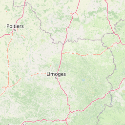
Use this park location map to pinpoint Lande de la Flotte et du Cluzeau in France, understand its exact geographic position, and read its mapped placement within the surrounding landscape more clearly.

Pigeon | © OpenStreetMap contributors

Location context for Lande de la Flotte et du Cluzeau

Haute-Vienne

Visual exploration of serpentinite rock outcrops, rare heath flora, and open plateau terrain

Lande de la Flotte et du Cluzeau Landscape Photography and Protected Scenery

Visual documentation reveals the stark contrast between stony serpentinite slopes and surrounding agricultural pastures across the Limousin plateau. Photographic records capture the unique low-growing heath vegetation and rare botanical communities defining this protected regional reserve.

Wide view of a dry heathland slope with brown grasses, exposed rocky outcrops, and sparse evergreen trees under a blue sky.

Park atlas

Discover adjacent geological reserves and connected regional landscapes across the Limousin plateau

Explore Parks Near Lande de la Flotte et du Cluzeau and Related Protected Areas

Compare Lande de la Flotte et du Cluzeau with other protected areas and nearby heathland sites across the surrounding region. Extended park browsing reveals regional geological patterns and related conservation landscapes throughout southern Haute-Vienne.
Nature reserveNouvelle-Aquitaine
About 36 km away#1 closest

Northwest

Réserve naturelle régionale du réseau de landes atlantiques du Parc naturel régional Périgord-Limousin

A networked regional nature reserve in Nouvelle-Aquitaine.

This protected area serves as a critical network of Atlantic heathland sites embedded within the larger Périgord-Limousin Regional Natural Park. By conserving these scattered clearings of acidic soil and low vegetation, the reserve maintains a distinct biogeographic feature far from the French coast, offering a clear view into how regional authorities manage fragmented open habitats in the Haute-Vienne.

Area
0.409 km²
Established
2015
IUCN
IV
Scope
Terrestrial
A soft watercolor painting of a natural landscape showing rolling green hills, a distant purple mountain range, and a calm body of water reflecting the light, with green foliage on the right bank.
Nature reserveNouvelle-Aquitaine
About 46 km away#2 closest

North

Réserve naturelle régionale des Sauvages: Protected Landscape and Regional Geography

Mapped Habitat Mosaic in the Haute-Vienne of Nouvelle-Aquitaine

Discover the geographic composition of Réserve naturelle régionale des Sauvages, a protected nature reserve in France that integrates diverse habitats including heather-dominated moorland, peatland, beech forest, and historical ponds. This site serves as a key component of the regional conservation landscape within the Haute-Vienne.

Area
0.826 km²
Established
2015
IUCN
IV
Relief
Upland
A horizontal watercolor illustration depicting a soft landscape with rolling hills, a body of water in the foreground, and pine trees on the right side.
Nature reserveNouvelle-Aquitaine
About 48 km away#3 closest

East

Réserve naturelle régionale de la haute vallée de la Vézère: Protected Highland Geography

Wetland ecosystems of the Corrèze and Plateau de Millevaches.

Representing a vital network of peatland and bog systems, this nature reserve in the Nouvelle-Aquitaine region preserves essential highland habitats. Its scattered parcels illustrate the complex wetland geography of the Massif Central, offering a focused look at how protected boundaries safeguard specialized ecosystems within the upper Vézère river catchment area.

Area
1.963 km²
Established
2015
IUCN
IV
Relief
Lowland
Nature reserveNouvelle-Aquitaine
About 59 km away#4 closest

West

Vallée de la Nizonne Nature Reserve: Mapped Geography and Protected Wetland Landscapes

A critical river corridor and Natura 2000 conservation zone in Nouvelle-Aquitaine.

Discover the geographic structure of the Vallée de la Nizonne, a protected area shaped by the flow of the Nizonne and Lizonne rivers. This landscape mosaic features peatlands, wet meadows, and alluvial forests that serve as a refuge for rare species. Gain insight into the regional terrain and conservation boundaries that define this important French wetland corridor.

Area
33.91 km²
Established
2016
Relief
Upland
Climate
Temperate
Nature reserveCharente
About 66 km away#5 closest

West

Val de Tardoire Nature Reserve: Geography and Protected Area Mapping in Charente

A detailed river valley landscape in Nouvelle-Aquitaine, France.

This protected area centers on the Tardoire river valley, featuring a high density of wet meadows, broadleaf forests, and rocky escarpments. The site represents a crucial node for European-interest habitats and diverse fauna, offering an in-depth look at the natural terrain and ecological composition of the Charente department.

Area
31.49 km²
Established
1999
Relief
Upland
Climate
Temperate
Nature reserveNouvelle-Aquitaine
About 69 km away#6 closest

West

Réserve naturelle régionale de la vallée de la Renaudie Protected Landscape and Map Atlas

A geological crossroads in the heart of Nouvelle-Aquitaine.

Trace the 6 kilometer stretch of the Réserve naturelle régionale de la vallée de la Renaudie. This protected area showcases an unusual geological interface between limestone and granite, creating a compact mosaic of riparian woodland, dry rocky cliffs, and meadows that support significant regional biodiversity.

Area
0.73 km²
Established
2012
IUCN
IV
Relief
Mixed relief
Protected areaLot
About 78 km away#7 closest

South

Vallée de la Dordogne quercynoise: Regional Protected Area and River Valley Geography

A detailed geographic study of limestone slopes and riparian corridors in the Lot department.

Spanning 5,567 hectares across the Lot department, this protected area preserves the ecological integrity of the Dordogne river. The region is marked by its transition from narrow, hill-enclosed upstream stretches to broader floodplain zones, creating a complex habitat mosaic of alluvial meadows, travertine springs, and rocky chasmophytic slopes that support important European biodiversity.

Area
55.67 km²
Established
2007
Relief
Upland
Climate
Temperate
Watercolor painting depicting a soft green landscape with rolling hills, riverbank vegetation, and a central waterway.
Nature reserveNouvelle-Aquitaine
About 79 km away#8 closest

Southeast

Réserve naturelle régionale des gorges de la Maronne et Tours de Merle: Protected Gorge Geography

Mapping the Maronne river basin and medieval towers in Nouvelle-Aquitaine

This protected area captures the distinct vertical relief of the Maronne river valley. The landscape profile includes steep rocky outcrops, narrow riparian corridors, and the historic site of the Tours de Merle. Exploring this regional reserve offers an understanding of how northern Massif Central ecosystems and medieval stone structures coexist within a protected framework in the heart of the Corrèze region.

Area
2.059 km²
Established
2025
IUCN
IV
Relief
Upland

Common questions about visiting, size, designation, and location context for Lande de la Flotte et du Cluzeau

Lande de la Flotte et du Cluzeau FAQs for park facts, access, geography, and protected area context

Find quick answers about Lande de la Flotte et du Cluzeau, including protected-area facts, park geography, trail and visitor context, and how the park fits into its surrounding country and regional landscape.
MoriAtlas Explorer

Continue Your Protected Areas Search Across the Global Atlas

Deepen your exploration by continuing the structured search for national parks and protected areas worldwide. Utilize the comprehensive filtering capabilities to compare different conservation landscapes and refine your understanding of global park geography. Discover more about the distribution and characteristics of protected natural areas.

Global natural geography