
Why Landschaftsschutzgebiet Bestwig stands out
Landschaftsschutzgebiet Bestwig is best known for combining a continuous, large-scale forested Sauerland landscape with the surviving traces of centuries of underground ore mining. The southern part of the area includes quartz-vein ore deposits that were worked over many centuries, leaving behind spoil heaps, mining relics, and settlement patterns that still shape the local landscape today. The area is also notable for the contrast between the quiet, largely unpopulated northern forest ridges of the Arnsberger Wald and the more open, agriculturally used mid-section along the Ruhr. Extensive Christmas tree and nursery plantations, alongside protected forest stands, give the area a distinctive mix of cultural land use and natural woodland in a single protected framework.
Landschaftsschutzgebiet Bestwig history and protected-area timeline
The protected landscape status of Landschaftsschutzgebiet Bestwig dates to 2008, when the Hochsauerland district council adopted the Bestwig landscape plan and designated the area as a Type A general landscape protection area. The plan, prepared by the district's lower landscape authority, set out the protection framework for seventeen individual landscape protection areas within the municipality, of which Bestwig is the largest by area.
Although the formal reserve is relatively recent, the landscapes it protects carry a much older human history. Geological processes in the southern part of the current protection area concentrated ore veins along quartz intrusions, and these deposits were mined over many centuries. Relics of this mining past, including spoil heaps and settlement patterns shaped by extractive industry, remain widespread and form an important cultural component of today's protected landscape.
Modern land use within the area also reflects more recent economic shifts. Alongside traditional forestry and limited agriculture, large portions of the protection area are dedicated to commercial Christmas tree cultivation and tree nursery production, making the reserve a representative example of how Sauerland landscapes combine ecological protection with established rural industries.
Landschaftsschutzgebiet Bestwig landscape and geographic character
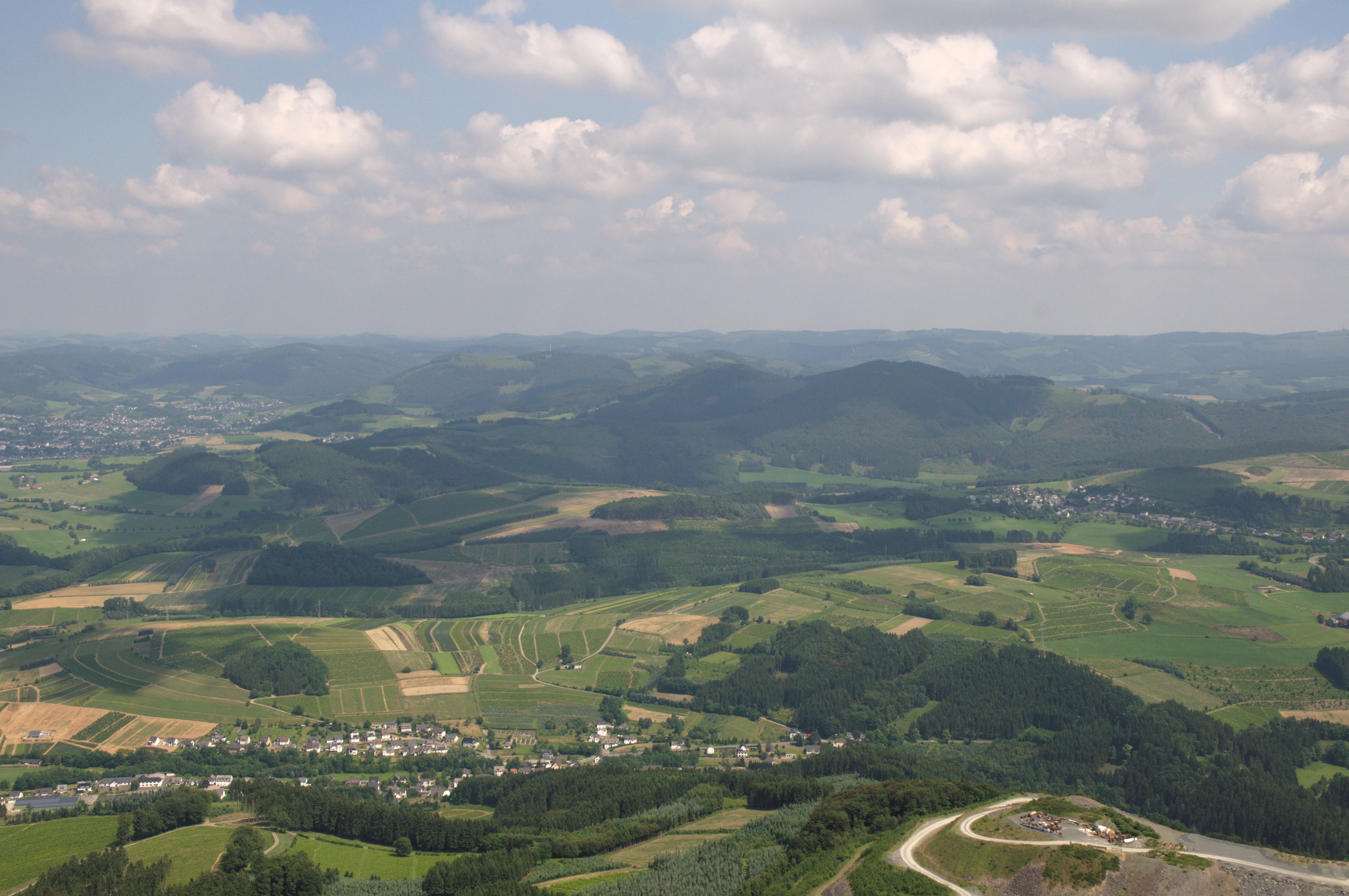
The landscape of Landschaftsschutzgebiet Bestwig varies sharply from north to south, following the classic topography of the central Sauerland. In the north, the area includes sections of the Arnsberger Wald, particularly the Plackwald, where elevation crests reach around 550 meters and the terrain forms broad, forested ridges with named summits such as Gemeinheitskopf, Wiemert, and Nuttlarer Höhe. These northern lands are largely unpopulated and are crossed by few major roads, with the L 776 being one of the only notable routes through the area.
Moving south, the land drops relatively steeply into the Oberruhrgesenke, the upper valley slopes between the forest ridges and the Ruhr river. This middle zone is dominated by south-facing slopes that descend from the Plackwald toward the Ruhr valley and continue into the lower areas around Ramsbeck. The warmer, sun-exposed slopes in this section support more open land, including meadows, fields, and the wide agricultural transitions typical of the upper Ruhr region.
The southern section of the protection area marks the northern fringe of the Hochsauerländer Schluchtgebirge, where hilltops rise above 700 meters before plunging several hundred meters into adjacent valleys over short distances. This intense relief produces a strongly forested landscape with very little open ground, while quartz veins trapped within the bedrock gave rise to centuries of ore mining. Today, the rocky outcrops and abandoned mining workings create distinctive structural features within the surrounding forest.
Landschaftsschutzgebiet Bestwig ecosystems, habitats, and plant life
Ecologically, Landschaftsschutzgebiet Bestwig is defined by extensive woodland, narrow strips of open agricultural land, and specialized habitats linked to its rocky and mining-influenced terrain. Forest covers the majority of the protected area, with the unpopulated northern Plackwald section supporting relatively undisturbed stands of broadleaf and mixed woodland alongside smaller remnants of bog woodland, known in German as Bruchwaldrelikte. Small beech forest patches also occur in this quieter northern zone.
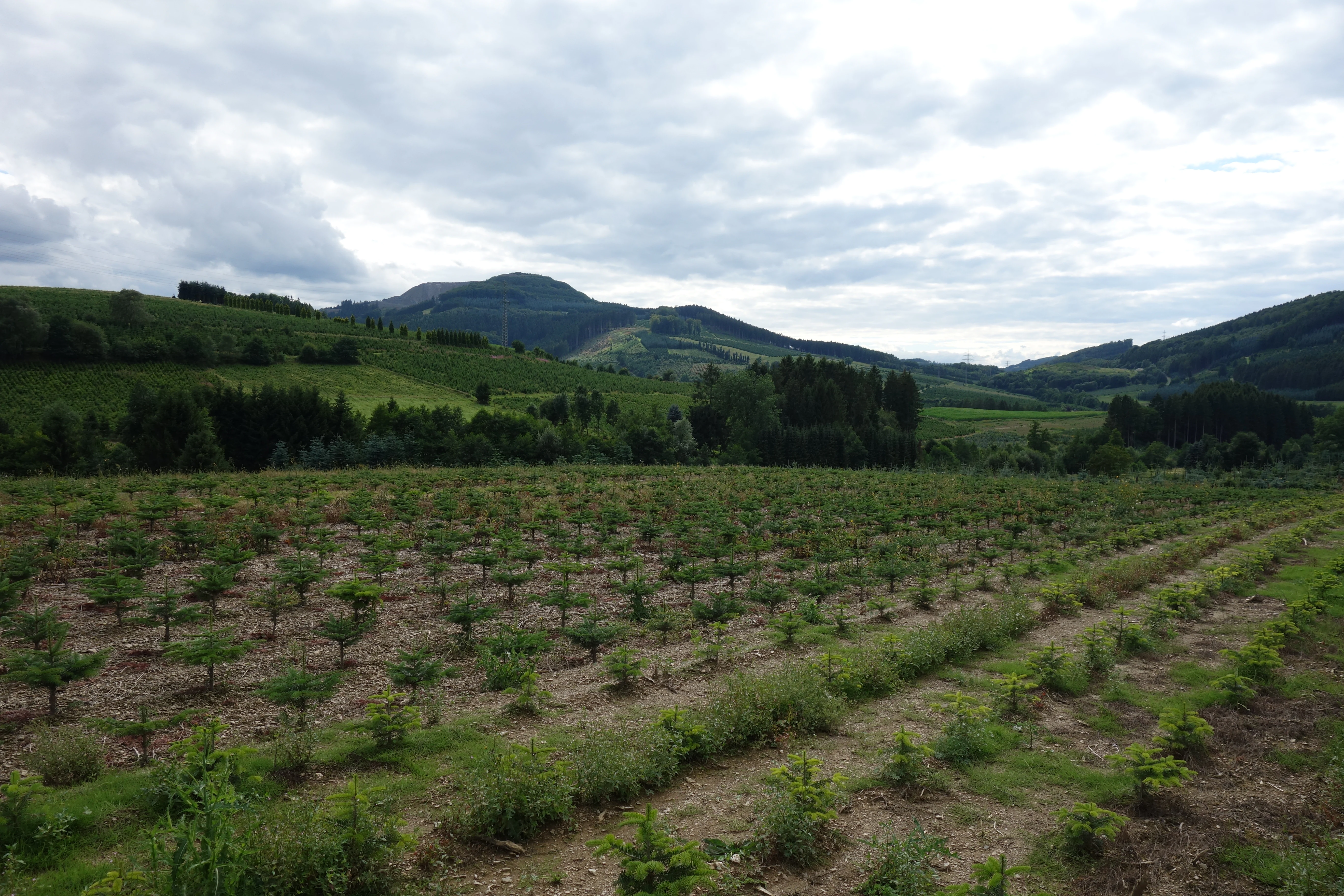
In the more populated middle section along the Ruhr, the natural character shifts toward a cultivated mosaic. Here, broad south-facing slopes carry larger shares of grassland and arable fields, while the flatter areas support extensive commercial Christmas tree, ornamental shrub, and nursery plantations. Although these cultivated zones are economically important, they still form part of the protected landscape and contribute to its distinctive land-use pattern.
The southern valleys and slopes along the northern edge of the Hochsauerländer Schluchtgebirge are characterized by very low proportions of open land and a clear dominance of forest. In addition to the closed woodland cover, the area contains abundant rocky outcrops and cliffs, which act as ecological special sites. Secondary habitats created by historical surface mining, in the form of spoil heaps, open ground, and disturbed substrates, add further habitat diversity within the otherwise forested terrain. The protection area also incorporates the eastern portion of the FFH area Halden bei Ramsbeck, linking the reserve to European habitat conservation networks.
Landschaftsschutzgebiet Bestwig conservation status and protection priorities
The conservation purpose of Landschaftsschutzgebiet Bestwig is to secure and maintain the natural recreation value of the area and the functional capacity of the natural environment in the face of varied human pressures such as settlement expansion, infrastructure, forestry, and energy development. By covering nearly all unbuilt land around the municipality of Bestwig, the reserve provides a continuous protective buffer between settlements and the surrounding forests, agricultural zones, and valley landscapes.
The protection framework is designed to maintain the existing balance of forest, farmland, and cultural land uses, including the large Christmas tree and nursery plantations that are characteristic of the region. Through its Type A general landscape protection status, the reserve imposes broader restrictions on construction and major land use change, while still allowing traditional forestry, agriculture, and certain forms of infrastructure and energy development under controlled conditions. This approach aims to keep the overall ecological character of the Sauerland landscape intact while accommodating the rural economic activities that have shaped it.
At a European level, the inclusion of the eastern portion of the Halden bei Ramsbeck FFH area within the protection zone adds a layer of habitat conservation significance, connecting the local landscape protection framework to broader efforts to preserve the specific rocky and mining-related habitats of this part of the Sauerland.
Landschaftsschutzgebiet Bestwig cultural meaning and human context
The cultural landscape of Landschaftsschutzgebiet Bestwig is closely tied to long-standing rural and extractive industries in the Sauerland. Centuries of ore mining along quartz veins in the southern part of the area left behind spoil heaps, small workings, and settlements that were originally tied to the mines. Although active mining has ended in most locations, the traces of this history still define the appearance of the southern valleys and ridges.
More recently, the area has become strongly associated with commercial Christmas tree and ornamental shrub cultivation, which today occupies large sections of the mid-elevations around Heringhausen, Halbeswig, and the slopes north of Ramsbeck. Combined with traditional forestry and small-scale farming, these cultural land uses give the protection area its characteristic mix of productive rural landscape and protected natural environment, reflecting the everyday economic life of the Sauerland communities within and around the reserve.
Top sights and standout views in Landschaftsschutzgebiet Bestwig
Landschaftsschutzgebiet Bestwig stands out for its large, continuous protected footprint that links forest ridges, Ruhr valley slopes, and high-relief mountain valleys into a single coherent area. The combination of extensive woodland, large-scale Christmas tree and nursery cultivation, and an underlying pattern of historic mining heritage gives the reserve a distinctive identity within the Hochsauerland district.
The inclusion of forest crests above 700 meters in the south, paired with the largely unpopulated Plackwald ridges in the north and the cultivated slopes of the Oberruhrgesenke in between, makes the area a representative cross-section of the central Sauerland. Its overlap with the eastern part of the Halden bei Ramsbeck FFH area further strengthens its role within the regional network of protected natural and cultural landscapes.
Best time to visit Landschaftsschutzgebiet Bestwig
Landschaftsschutzgebiet Bestwig is an all-season rural landscape in the Sauerland, where the experience of the protected area changes noticeably with the time of year. Late spring and early summer bring fresh green forest cover, open meadows along the south-facing slopes, and generally favorable conditions for walking through the mixed terrain of forest and agricultural land.
Autumn highlights the contrast between coniferous forest stands and the beech and mixed woodland remnants, while also marking the visual peak of the Christmas tree cultivation that shapes much of the area. Winter can give the landscape a quieter, more secluded character, especially in the unpopulated northern Plackwald section, though snow and seasonal conditions can affect access on smaller forest roads. Visitors interested in the mining-history aspects of the southern valleys will find the rocky terrain and spoil heaps most readable in low vegetation periods such as late autumn or early spring.