
Mori Atlas logo
Protected landscapeLandschaftsschutzgebiet Büren

Explore the geography of hedgerow networks, wet meadows, and headwater springs within this German protected area.

Landschaftsschutzgebiet Büren: Mapping the Protected Rural Mosaic in the Kreis Paderborn District

Landschaftsschutzgebiet Büren represents an expansive, finely patterned agricultural mosaic situated across the Kreis Paderborn district of North Rhine-Westphalia. This protected landscape is defined by the persistent integration of small-scale semi-natural features, including riparian woodland strips, traditional wet meadow systems, and headwater spring clusters, nestled within the broader undulating Westphalian farmland. The geography of the area serves as a significant example of how durable natural frameworks are maintained within an active agricultural matrix, tracing the gentle transition from lowland plains toward the slopes of the Egge hills.

landscape protection areaLandschaftsschutzgebietWestphaliafarmland mosaichedgerowswet meadows
A flat-design, colorful illustration depicting a valley with two waterfalls falling from cliffs into a central winding river, surrounded by trees and wildflowers under a sunset sky.

Landschaftsschutzgebiet Büren

Protected landscape

Park overview

Structured park overview, official facts, and landscape profile for Landschaftsschutzgebiet Büren

Landschaftsschutzgebiet Büren park facts, protected area profile, and essential visitor context

Review the core facts for Landschaftsschutzgebiet Büren, including designation, size, terrain, visitor scale, habitats, and operating context in one park-focused overview.

About Landschaftsschutzgebiet Büren

The Landschaftsschutzgebiet Büren is a substantial protected landscape designation in the Paderborn district of North Rhine-Westphalia, in the western-central part of Germany. Originally laid out to encompass wide tracts of forest and open land in the former Kreis Büren, it has been reshaped by more than four decades of administrative change. Where new municipal landscape plans have been approved, considerable areas of the original protection zone have been reorganized into stricter or more specifically defined categories, but a meaningful core still remains under the original LSG umbrella, particularly in those municipalities where no successor landscape plan had yet been adopted by 2020.

Geographically, the area lies on the rolling farmland and hill country east of Paderborn, within the broader transition between the Westphalian Börde lowlands and the lower slopes of the Egge hills. Its terrain is gently undulating rather than mountainous, shaped by small valleys, spring heads, slow-moving brooks, and patches of woodland interspersed with agricultural fields. The landscape reads as strongly cultural; hedgerows, small wooded strips along field edges, and riparian shrub corridors are recurring elements that give the area much of its ecological and visual structure.

Hydrologically, the protected area encompasses a number of small spring systems and headwater features, including the Gellinghausener Quelle. These points are ecologically important because they anchor stable moisture regimes that sustain wet meadows, marshy patches, and a distinct suite of wetland plants. The Gunnewiesen in the Delbrück area are among the better-known meadow complexes inside the LSG and illustrate how traditional grassland use continues to coexist with the protection regime rather than being excluded by it.

The protection rules attached to the LSG are deliberately broad and precautionary. In addition to safeguards for the general rural landscape character, the original 1974 ordinance specifically prohibits the conversion of usable farmland into forest, with limited exceptions for genuinely derelict land, and it forbids the removal or damaging of hedgerows and field-edge or waterside woody strips in the open countryside. These targeted restrictions reflect the recognition that the area's ecological value depends heavily on small landscape features rather than on any single large habitat.

From a practical standpoint, much of the LSG continues to be worked agricultural land, and its ecological value is closely tied to the maintenance of low-intensity traditional land use. This makes the area a representative example of how German landscape protection areas operate in heavily farmed regions: less about exclusion than about regulating the small-scale changes that would otherwise erode a long-established rural mosaic.

Quick facts and research context for Landschaftsschutzgebiet Büren

The protected landscape lies in the eastern part of North Rhine-Westphalia within today's Kreis Paderborn and reaches into the municipal areas of Delbrück, Salzkotten, Lichtenau, and Bad Wünnenberg. It was first designated on November 1, 1974, with an original area of 14,295.43 hectares, making it one of the more substantial landscape protection areas in the region.

By 2020 the area existed as a patchwork of roughly 24 separate sub-areas, reflecting decades of gradual absorption into newer municipal landscape plans. The protection regime specifically prohibits the afforestation of usable farmland, with limited exceptions for genuinely derelict land, and forbids the removal or damaging of hedgerows, field wooded strips, and riparian shrubs in the open countryside.

Protection and recognition

Documented terrestrial protection scope and international designation records

Landschaftsschutzgebiet Büren Protection Status and Conservation Framework

Examine the verified terrestrial protection status and management scope recorded for Landschaftsschutzgebiet Büren. Review the documented conservation framework and official designation history compiled for this protected area.

Protection details

Protection scope
Terrestrial
Park context

Deeper park guide and search-rich context for Landschaftsschutzgebiet Büren

Landschaftsschutzgebiet Büren history, landscape, wildlife, and travel context

Explore Landschaftsschutzgebiet Büren through its history, landscape character, ecosystems, wildlife, conservation priorities, cultural context, and seasonal travel timing in a structured park guide built for atlas discovery and search intent.

Why Landschaftsschutzgebiet Büren stands out

The area is best known for the way it preserves a large, finely patterned rural mosaic of woodland patches, hedgerow networks, wet meadows, and small headwater springs across the eastern Westphalian farmland belt. Among its individually recognizable features are the Gunnewiesen meadows in the Delbrück municipal area, the Gellinghausener Quelle spring, and active white stork nesting sites in the Heitwinkel area near Boke. These elements together illustrate that the LSG's ecological significance depends less on large contiguous habitats than on a durable framework of small semi-natural features embedded in working farmland.
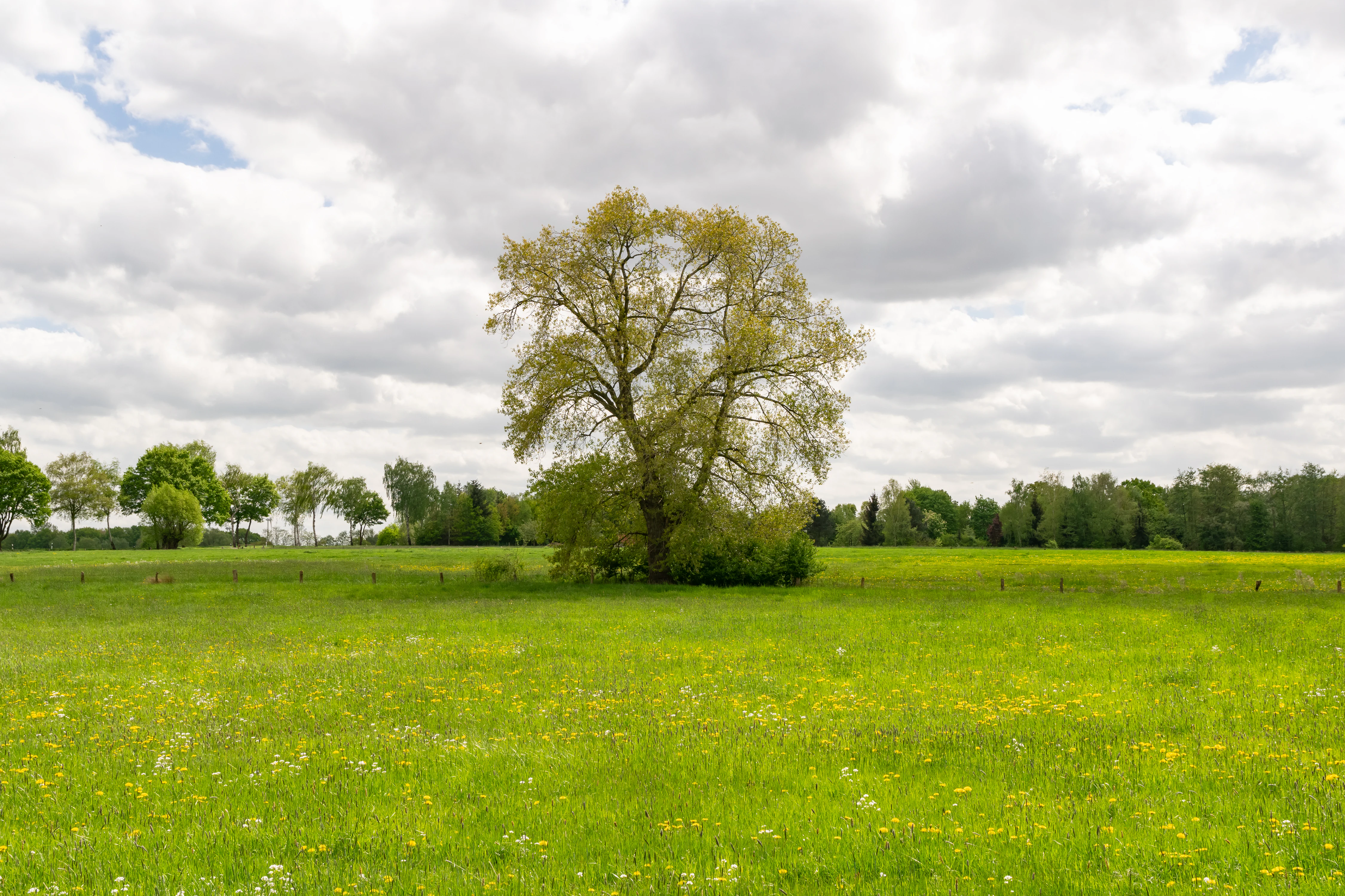
A large, leafy tree stands alone in the middle of a vibrant green meadow under a cloudy sky.
A solitary tree standing in a green meadow within the Landschaftsschutzgebiet Büren near Gunnewiesen.

Landschaftsschutzgebiet Büren history and protected-area timeline

The protected landscape traces back to a municipal ordinance issued on November 1, 1974, by the former Kreis Büren under the authority of the Regierungspräsident in Detmold. At its original designation the area covered roughly 14,295 hectares, placing it among the larger landscape protection areas established in the region during the 1970s wave of West German nature conservation planning.

When first laid out, the ordinance imposed a fixed term that would have caused the protection to lapse in 1994. That termination never occurred. The 2000 North Rhine-Westphalia nature conservation law (LNatSchG NRW) included transitional provisions under § 79 that automatically keep pre-existing landscape protection ordinances in force until a successor landscape plan or replacement administrative regulation is adopted for the same area.

The result has been an unusually long period of legislative continuity. Across much of the former Kreis Büren, however, municipal landscape plans have gradually been approved, and large tracts of the original LSG have been reorganized into other protection categories, including more specific landscape plan zones. Today's surviving core of the LSG Büren is essentially the portion of the original area that has not yet been overtaken by such newer planning instruments; the largest surviving pieces lie in Delbrück, Salzkotten, and Lichtenau, with a smaller fragment in Bad Wünnenberg.

Landschaftsschutzgebiet Büren landscape and geographic character

The landscape of the LSG is shaped by the gentle transition between the Westphalian lowland farmland belt to the west and the lower slopes of the Egge hills to the east. There are no dramatic summits, deep gorges, or sizeable standing water bodies within its boundaries; instead the area reads as a soft, undulating plain that rises and falls in long, low waves across many kilometers.

Woodland patches, hedgerow networks, and field clusters alternate across this undulating terrain, producing a strongly patterned mosaic when viewed from any elevated vantage point. Small spring heads and shallow valley bottoms periodically break up the otherwise agricultural surface.

Because the area is embedded in a worked agricultural matrix, most perceptible landscape change comes from seasonal shifts in crop cover, the flowering of meadow strips, and the slow seasonal turn of woodland leaf cover rather than from any rocky or alpine contrast. This combination of subdued topography with a dense small-scale landscape structure is characteristic of much of central Westphalian countryside and gives the LSG much of its visual identity.
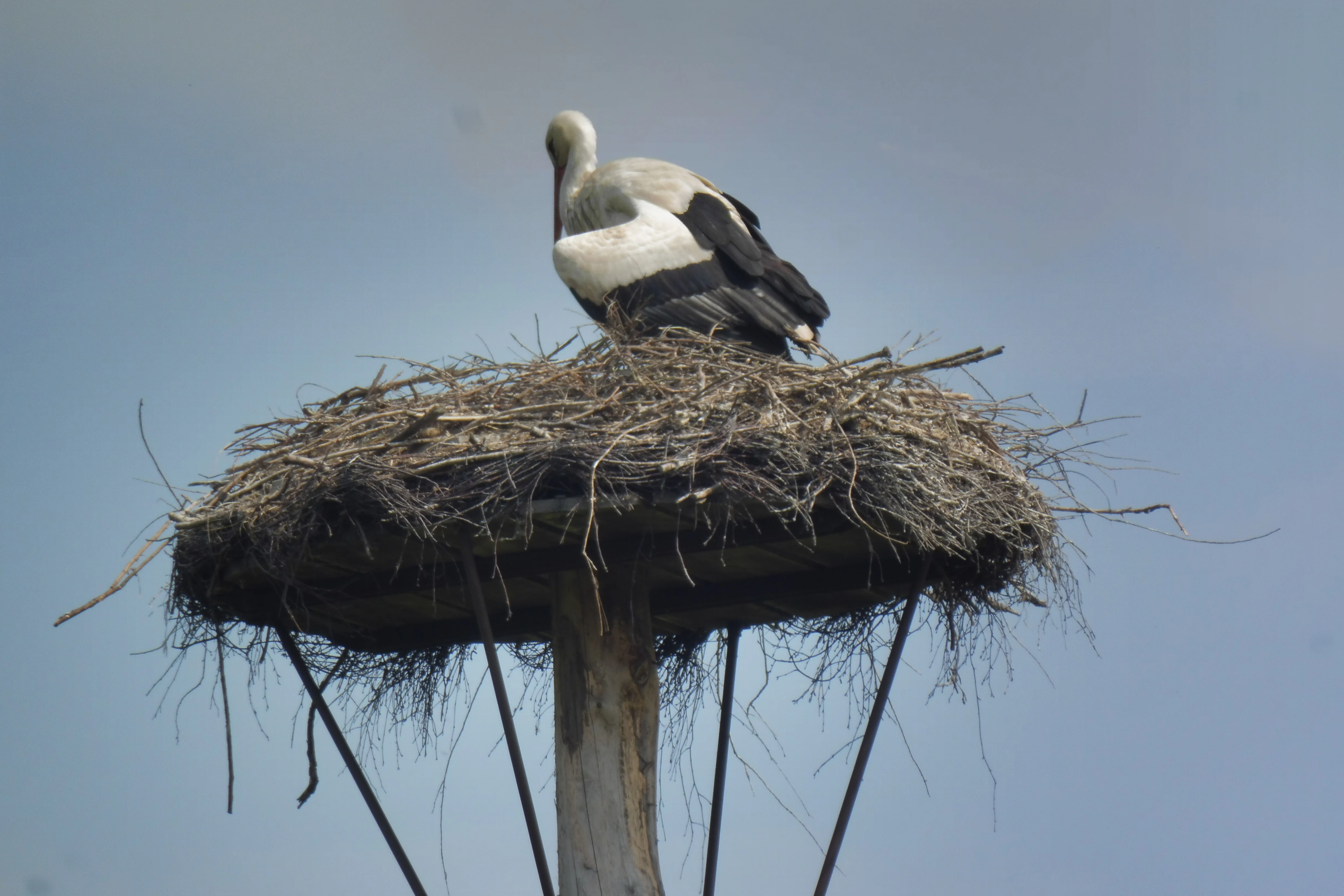
A white stork standing in a large stick nest atop a wooden pole against a pale blue sky.
A white stork perched on a large nest platform in the Heitwinkel area.

Landschaftsschutzgebiet Büren ecosystems, habitats, and plant life

Ecologically, the area is dominated by a richly structured agricultural matrix rather than by large contiguous natural habitats. Woodland covers meaningful parts of the area, but the ecological backbone of the protection regime lies in the network of hedgerows, field-margin shrub strips, riparian shrub belts, springs, and small moist depressions that run through the farmland.

These small linear and point features create the conditions for a diverse semi-natural flora and a complex insect community that, in turn, supports breeding birds and other wildlife. The wet meadows around features like the Gunnewiesen and the headwater zone of the Gellinghausener Quelle add habitat types that are otherwise scarce in the surrounding intensively farmed terrain.

The overall ecological character is best described as a long-established mixed cultural landscape, maintained by traditional land use and protected against the most disruptive forms of land conversion. Its value is therefore structural rather than spectacular: the area functions as an ecological network across many square kilometers rather than as a single showcase habitat.

Landschaftsschutzgebiet Büren wildlife and species highlights

The most distinctive wildlife signal readily tied to the LSG in the available documentation is the continued breeding presence of white storks in the area, with documented nesting activity in the Heitwinkel zone near Boke. This reflects the combination of open wet meadows, pasture margins, and accessible foraging habitat that characterizes parts of the LSG and that is relatively unusual in modern intensively farmed Westphalian farmland.

More broadly, the dense hedgerow network and the small wetland pockets provide breeding habitat for a range of common but ecologically important farmland birds, as well as foraging and refuge habitat for small mammals and amphibians associated with cool, moist microhabitats. The spring and meadow features such as the Gellinghausener Quelle and the Gunnewiesen anchor localized concentrations of wetland-dependent fauna.

The area is therefore less a destination for spectacular megafauna viewing than a representative case of how a structured farmland mosaic supports a functioning breeding bird and small-fauna community across a large working landscape.

Landschaftsschutzgebiet Büren conservation status and protection priorities

From a conservation perspective, the LSG Büren is important primarily as a regulatory framework for protecting a mature Westphalian cultural landscape from the most disruptive forms of land conversion. Unlike stricter categories such as nature reserves or national parks, it does not exclude human land use; instead it sets targeted boundaries around what kinds of changes are allowed within the protected perimeter.

The most consequential of those boundaries is the prohibition on converting usable farmland into forest, with limited allowances for genuinely derelict land. The second is the explicit protection of hedgerows, field-edge wooded strips, and riparian shrub corridors, which are otherwise among the most frequently removed small features in agricultural regions. Together these rules explicitly target the small-scale structural elements that maintain ecological continuity in a farmed landscape.

The longer-term conservation significance of the LSG is also administrative. Because the original 1974 ordinance would otherwise have expired in 1994 but has been kept alive by the transitional provisions of the 2000 NRW nature conservation law, the area illustrates how legacy landscape protection instruments persist while municipal landscape plans are gradually being developed. In places where those newer plans have replaced the LSG with more specific zones, the area has effectively received a sharper conservation profile; in places where they have not, the LSG continues to function as the primary safeguard.

Landschaftsschutzgebiet Büren cultural meaning and human context

The landscape protected by the LSG is, in cultural terms, a working Westphalian farming landscape rather than an untouched natural area. Hedgerows, field wood strips, and riparian shrub belts have been maintained by generations of mixed farming practice, and the original 1974 ordinance reflects a deliberate choice to regulate agricultural land use rather than to remove it. In that sense the area is also a piece of regional rural heritage, recognized through nature protection law not only for its ecological content but for the long-maintained agricultural pattern that produced it.

Top sights and standout views in Landschaftsschutzgebiet Büren

The LSG's main highlights are its sheer extent, its character as a working agricultural mosaic rather than an untouched wilderness, and the persistence of small but ecologically meaningful features such as the Gunnewiesen meadows, the Gellinghausener Quelle spring, and the documented white stork nesting ground in the Heitwinkel area. Together these give the protected area a recognizable and durable identity within the broader Paderborn landscape, distinct from both the more strictly protected reserves and the surrounding intensively used farmland.

Monthly climate preview

Long-term representative temperature and precipitation averages across the protected area

Landschaftsschutzgebiet Büren Climate Normals and Annual Temperature Patterns

Historical climate records from 1991 to 2020 document the measured annual temperature and precipitation rhythm across a representative coordinate within Landschaftsschutzgebiet Büren. Accessing the complete monthly profile provides detailed context on long-term thermal variations and precipitation distributions across the protected landscape.
Annual mean9 °C
0 °C18 °C
Jan
Feb
Mar
Apr
May12°
Jun15°
Jul18°
Aug18°
Sep14°
Oct
Nov
Dec
Warmest month
July

18 °C

Coolest month
January

-0.2 °C

Wettest month
July

2.6 mm/day

Driest month
April

1.7 mm/day

Park location guide

Geography guide, regional context, and park location map for Landschaftsschutzgebiet Büren

Landschaftsschutzgebiet Büren park geography, regions, and map view in Germany

Understand where Landschaftsschutzgebiet Büren sits in Germany through a broader geographic reading of the surrounding landscape, nearby location context, and its mapped position within the national park landscape.

How Landschaftsschutzgebiet Büren fits into Germany

Germany is a federal republic in Western and Central Europe with a population of over 83 million across sixteen constituent states. It is Europe's largest economy by nominal GDP and a major global exporter and importer. The capital is Berlin, and the country borders Denmark, Poland, Czech Republic, Austria, Switzerland, France, Luxembourg, Belgium, and the Netherlands.

Wider geography shaping Landschaftsschutzgebiet Büren in Germany

Germany is located in Western and Central Europe, spanning 357,022 km². It borders Denmark to the north, Poland and the Czech Republic to the east, Austria and Switzerland to the south, and France, Luxembourg, Belgium, and the Netherlands to the west. The country has coastlines on the Baltic Sea and North Sea to the north, with the Alps located in the southern region.

Map view of Landschaftsschutzgebiet Büren

Use this park location map to pinpoint Landschaftsschutzgebiet Büren in Germany, understand its exact geographic position, and read its mapped placement within the surrounding landscape more clearly.

Pigeon | © OpenStreetMap contributors

Location context for Landschaftsschutzgebiet Büren

Kreis Paderborn

Visual reference collection highlighting rural mosaics, wet meadows, and habitat terrain

Landschaftsschutzgebiet Büren Photos: Scenery and Mapped Protected Landscapes

Visual records capture the distinctive terrain, field patterns, and small semi-natural habitats characteristic of Landschaftsschutzgebiet Büren. Examining these protected-area photographs helps observers understand the fine-scale rural mosaic and undulating Westphalian landscape structure more clearly.

A large, leafy tree stands alone in the middle of a vibrant green meadow under a cloudy sky.

A small stream flows through a grassy area surrounded by pollarded willow trees in early spring.

A white stork standing in a large stick nest atop a wooden pole against a pale blue sky.

Park atlas

Compare regional Westphalian landscapes and connected nature reserves

Explore Parks Near Landschaftsschutzgebiet Büren and Surrounding Protected Areas

Continue browsing other parks near Landschaftsschutzgebiet Büren to examine similar rural mosaics, valley features, and woodland patches across the Paderborn district. Comparing adjacent protected areas reveals broader regional geography and reveals how lowland agricultural zones support local conservation.
Nature reserveNorth Rhine-Westphalia
About 8.6 km away#1 closest

Northwest

Ziegenberg Nature Reserve: Geographic Overview and Protected Area Boundaries

Riparian landscapes and calcareous slopes in the Paderborn region

Ziegenberg offers a distinct look at the intersection of calcareous hillside forests and moist stream environments in Germany. The reserve protects a concentrated diversity of habitats ranging from orchid-rich woodland to alluvial streamside corridors, serving as an important ecological link within the Paderborn district's natural geography.

Area
0.028 km²
Established
1984
IUCN
IV
Nature reservePaderborn
About 9.5 km away#2 closest

Northwest

Ziegenberg Nature Reserve: Protected Landscape Geography and Paderborn River Corridors

Mapping the forest ridges and floodplains of Paderborn district.

Discover the geographic composition of Ziegenberg, a nature reserve in Paderborn that blends riparian meadows with stony forest ridges. This protected site demonstrates the complex relationship between municipal expansion, river hydrology, and conservation within the German landscape.

Area
0.81 km²
Established
1980
Relief
Upland
Climate
Temperate
A horizontal watercolor painting showing a soft landscape with a winding stream, grassy meadows, and distant forested hills under a pale sky.
Nature reserveGermany
About 9.6 km away#3 closest

Southeast

Marschallshagen und Nonnenholz mit oberem Altenautal Protected Nature Reserve Map

Ecological landscape and forest geography in the Paderborn district

Covering approximately 1,943 hectares, this nature reserve is a major component of the regional conservation framework. The landscape creates a layered mosaic of closed beech forest, near-natural running water, and floodplain woodland, serving as a significant site for European bird protection programs.

Area
19.43 km²
Established
2002
A soft, horizontal watercolor painting showing a winding stream flowing through a green valley with gentle hills and trees in the background.
Nature reserveNordrhein-Westfalen
About 12 km away#4 closest

Northeast

Naturschutzgebiet Schmittwassertal: A Protected Nature Reserve in the Paderborn District

Mapping brook corridors and calcareous grassland landscapes in Westphalia.

Naturschutzgebiet Schmittwassertal represents a fragmented yet ecologically vital nature reserve in Nordrhein-Westfalen. The area encompasses 53.6 hectares of stream-cut valleys and limestone-influenced slopes. This atlas entry details the mosaic of habitats ranging from alder-lined brook corridors to nutrient-poor Borstgrasrasen and semi-dry calcareous grasslands, highlighting its function as a connected biological corridor.

Area
0.536 km²
Established
2014
Relief
Upland
Climate
Temperate
A horizontal watercolor painting showing rolling, abstract hills with patches of green, yellow, and soft red, accented with stylized coniferous forest lines.
Nature reserveNordrhein-Westfalen
About 12 km away#5 closest

Southwest

Leiberger Wald Nature Reserve: Protected Woodland and Stream Geography in Paderborn

A mapped forest complex within the Nordrhein-Westfalen landscape

Leiberger Wald encompasses an extensive series of beech forests and riparian habitats that form a key protected node in the Kreis Paderborn. As a significant nature reserve, the area supports a wide range of woodland and aquatic species, serving as a critical refuge within the broader ecological network of western Germany.

Area
17.86 km²
Established
1994
IUCN
IV
Protected landscapeKreis Paderborn
About 12 km away#6 closest

Southwest

Landschaftsschutzgebiet FFH-Gebiet Wälder bei Büren: Regional Protected Forest Landscapes

Geographic map and protected area context in Kreis Paderborn

Landschaftsschutzgebiet FFH-Gebiet Wälder bei Büren functions as a European-level habitat site defined by its interconnected beech forest mosaic. The area is characterized by a mix of woodruff and rough blue-grass beech woodland, interwoven with intermittent stream courses, source areas, and geological sinkholes that create varied microhabitats within the North Rhine-Westphalia landscape.

Area
28.045 km²
Established
2007
Relief
Upland
Climate
Temperate
A soft watercolor painting depicting a meandering stream through a grassy valley with rolling, tree-covered hills in the background.
Nature reserveNorth Rhine-Westphalia
About 14 km away#7 closest

Southeast

Schwarzbachtal (PB): A Protected Stream Valley Landscape in North Rhine-Westphalia

Mapped nature reserve and valley habitat geography

Spanning over 200 hectares in the Paderborn district, Schwarzbachtal (PB) is a core nature reserve that protects the delicate stream valley landscape of the Schwarzbach. This area serves as a significant example of long-term conservation management in North Rhine-Westphalia, offering structured insight into regional habitat patterns and valley topography.

Area
2.206 km²
Established
2014
IUCN
IV
A watercolor painting showing a green landscape with a winding river and distant hills under a light pink sky.
Protected landscapeKreis Paderborn
About 14 km away#8 closest

North

Landschaftsschutzgebiet Fließgewässer und Auen: Regional Protected Landscape Overview

Riverine floodplain corridors and valley habitats in Paderborn

This protected landscape in Kreis Paderborn sustains essential habitat connectivity along river valleys including the Lippe and Beke. Its design features a fragmented network of sixteen sub-areas, showcasing how floodplain vegetation, wet meadows, and riparian corridors function within an urban-adjacent environment.

Area
9.583 km²
Established
1999
Relief
Lowland
Scope
Terrestrial

Common questions about visiting, size, designation, and location context for Landschaftsschutzgebiet Büren

Landschaftsschutzgebiet Büren FAQs for park facts, access, geography, and protected area context

Find quick answers about Landschaftsschutzgebiet Büren, including protected-area facts, park geography, trail and visitor context, and how the park fits into its surrounding country and regional landscape.
MoriAtlas Explorer

Continue Your Protected Areas Search Across the Global Atlas

Deepen your exploration by continuing the structured search for national parks and protected areas worldwide. Utilize the comprehensive filtering capabilities to compare different conservation landscapes and refine your understanding of global park geography. Discover more about the distribution and characteristics of protected natural areas.

Global natural geography