Mori Atlas logo
Nature reserveLanghorst von Hainburg und Seligenstadt

Understanding the floodplain forest and relic stream geography in Landkreis Offenbach

Langhorst von Hainburg und Seligenstadt Nature Reserve: Mapped Protected Landscapes and Geography

(Naturschutzgebiet Langhorst von Hainburg und Seligenstadt)

Langhorst von Hainburg und Seligenstadt represents a significant protected floodplain area in the German district of Landkreis Offenbach. This nature reserve preserves a complex mosaic of broadleaf forest and extensive wet meadows along the historic Main river valley. Through this detailed geographic focus, examine the terrain and ecological structure formed by the Werniggraben and Weihersbach stream channels within the regional context of southern Hesse.

floodplain forestbroadleaf forestwet meadowMain valleyHolocene floodplainnature reserve

Langhorst von Hainburg und Seligenstadt

Nature reserve

Park overview

Structured park overview, official facts, and landscape profile for Langhorst von Hainburg und Seligenstadt

Langhorst von Hainburg und Seligenstadt park facts, protected area profile, and essential visitor context

Review the core facts for Langhorst von Hainburg und Seligenstadt, including designation, size, terrain, visitor scale, habitats, and operating context in one park-focused overview.

About Langhorst von Hainburg und Seligenstadt

Langhorst von Hainburg und Seligenstadt is a compact nature reserve in southern Hesse that captures an unusually well preserved slice of the historic Main floodplain landscape. Located between the Hainburg district of Hainstadt and the Seligenstadt district of Froschhausen, it lies in a region where centuries of settlement have largely transformed the natural environment, making the reserve's remaining floodplain forest and meadow systems particularly valuable from both an ecological and a landscape historical perspective.

The protected area is dominated by near natural, structurally diverse broadleaf woodland. The species composition and vertical structure of this forest reflect long, undisturbed development typical of floodplain sites along larger rivers in central Europe. Open, ecologically valuable wet meadows form an important secondary component of the habitat mosaic, and the management of these grasslands has been deliberately kept extensive in order to maintain their floristic and faunal richness.

Two streams define much of the reserve's character: the Werniggraben and the Weihersbach. Both are regarded as relics of former arms of the River Main that existed in early post glacial times. Their preserved course through woodland and meadow adds a strong landscape historical dimension to the reserve. Together, the floodplain forest, wet meadows, and ancient stream channels form an integrated floodplain ecosystem that once covered far larger areas of the Mainaue before agricultural intensification and urban development.

The reserve covers around 82 hectares and was formally designated as a nature protection area in 1996. Its legal purpose explicitly targets the preservation and continued development of typical and particularly attractive landscape elements of the Holocene Mainaue, including near natural, species rich broadleaf forest and extensive wet meadows. As an IUCN Category IV site, it functions primarily as a habitat and species management area, combining protective designation with active stewardship of the underlying land use.

Quick facts and research context for Langhorst von Hainburg und Seligenstadt

Langhorst von Hainburg und Seligenstadt is a protected nature reserve (Naturschutzgebiet) located in the Landkreis Offenbach in southern Hesse, between the municipal areas of Hainburg and Seligenstadt. The reserve occupies about 82 hectares of land situated in the floodplain landscape of the River Main.

Its core habitats include near natural broadleaf forests, extensive grassland zones, and wet meadows, traversed by two small streams that originate as relic channels of the ancient Main river. The reserve carries the official designation NSG 1438025 and is administered by the lower nature conservation authority of the Landkreis Offenbach. It was legally established in 1996 and is recognized globally with a World Database on Protected Areas entry.

Protection and recognition

Documented terrestrial protection metrics and official registry records

Langhorst von Hainburg und Seligenstadt Protection Status and Dataset Records

Langhorst von Hainburg und Seligenstadt maintains documented terrestrial protection status within global conservation registries and spatial databases. Official records outline the baseline designation framework and administrative parameters governing the protected landscape.

Protection details

Protection scope
Terrestrial
WDPA ID
164371
Park context

Deeper park guide and search-rich context for Langhorst von Hainburg und Seligenstadt

Langhorst von Hainburg und Seligenstadt history, landscape, wildlife, and travel context

Explore Langhorst von Hainburg und Seligenstadt through its history, landscape character, ecosystems, wildlife, conservation priorities, cultural context, and seasonal travel timing in a structured park guide built for atlas discovery and search intent.

Why Langhorst von Hainburg und Seligenstadt stands out

Langhorst von Hainburg und Seligenstadt is best known for preserving a coherent, well structured example of the Holocene Main floodplain, where near natural broadleaf forest meets open wet meadow along the course of two small relic stream channels. The combination of habitat diversity, historical landscape character, and small size makes it a focused refuge for floodplain ecology in an otherwise heavily populated area of southern Hesse.
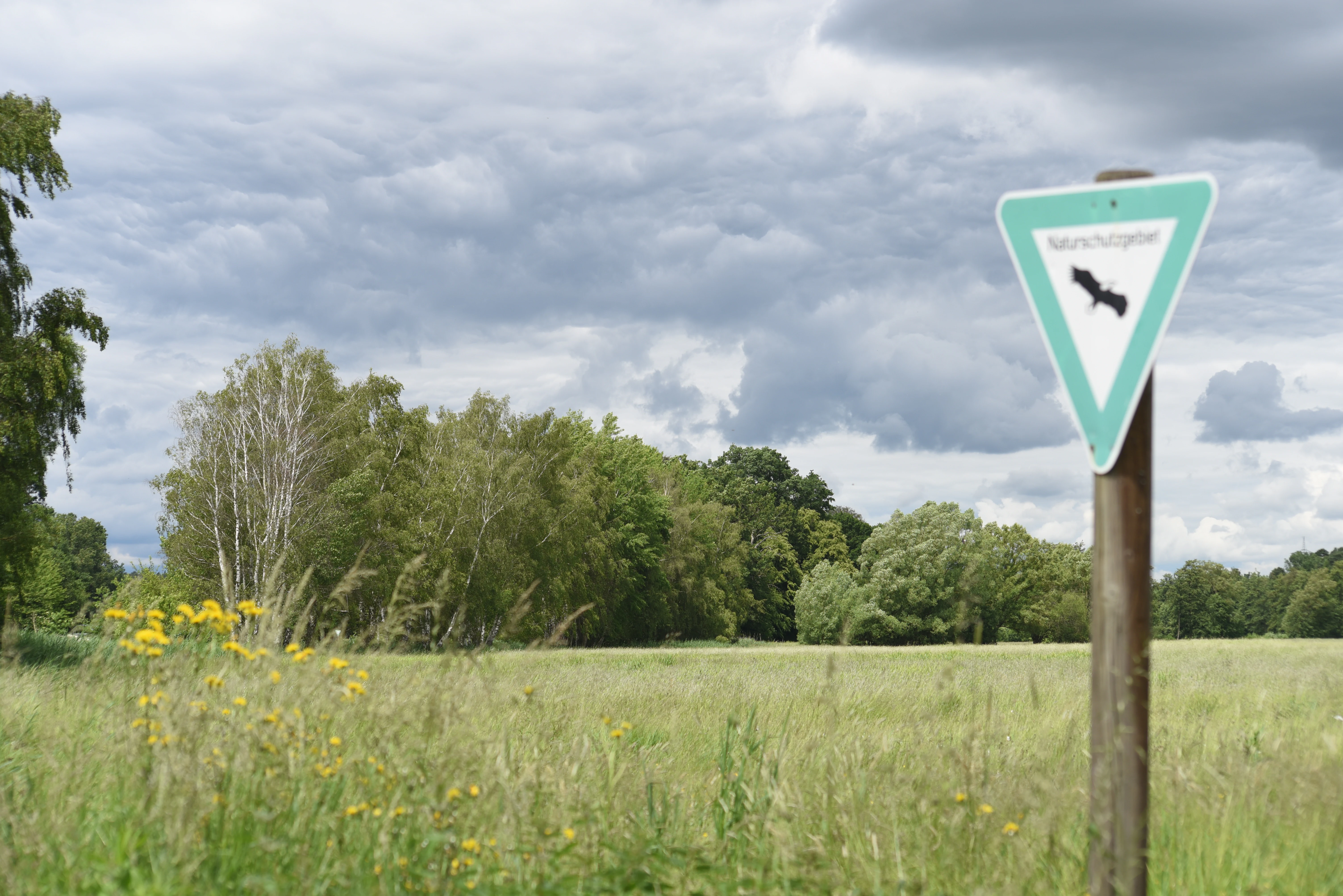
A triangular German nature reserve sign, marked with a black eagle silhouette, stands on a wooden post in a grassy meadow with trees in the background under a cloudy sky.
A nature reserve sign at the edge of a meadow in the Langhorst von Hainburg und Seligenstadt area.

Langhorst von Hainburg und Seligenstadt history and protected-area timeline

The legal protection of Langhorst von Hainburg und Seligenstadt dates to 1996, when the area was formally designated as a nature reserve (Naturschutzgebiet) under Hessian conservation law. The designation reflects growing awareness of the ecological value of surviving floodplain forest fragments along the River Main, much of which had been lost elsewhere in the region to agriculture, gravel extraction, and urban expansion.

Although formal protection is relatively recent, the ecological and landscape historical character of the site extends much further back. The two streams that traverse the reserve, the Werniggraben and the Weihersbach, are considered relic channels of post glacial Main river arms, indicating that the present day landscape preserves features shaped thousands of years ago by the shifting course of the Main. Over the modern era, the surrounding floodplain was increasingly cultivated, but parts of the forest and meadow system here were preserved, allowing a relatively intact and diverse habitat to survive within an intensively used regional landscape.

By the late twentieth century, conservation authorities in the Landkreis Offenbach identified this surviving floodplain mosaic as worthy of formal protection. The 1996 designation brought the site into the Hessian network of nature reserves and established the legal framework for ongoing management, including the extensive use of meadows and the protection of the near natural broadleaf forest stands.

Langhorst von Hainburg und Seligenstadt landscape and geographic character

The landscape of Langhorst von Hainburg und Seligenstadt is shaped by the gentle topography of the Main floodplain. The reserve lies on low lying, historically water influenced ground, where the proximity of the former river channels and the underlying geology have produced conditions favorable for both deciduous forest and open wet grassland.

The forest itself is not a uniform stand but a structurally diverse mosaic with multiple layers of canopy, understory, and ground vegetation. This vertical complexity, combined with variation in light availability along the stream corridors, creates a heterogeneous habitat texture that is characteristic of high quality floodplain forest. The presence of standing and downed deadwood, varied age classes, and a mix of species further adds to the structural richness of the woodland.

The open grassland areas adjoining the forest are typically low lying meadows that retain moisture for much of the year. These wet meadows support distinctive plant communities adapted to periodic saturation and to traditional, low intensity management. The combination of grassland, woodland, and slow flowing relic streams gives the reserve a layered landscape character that contrasts with the more intensively shaped surroundings of Hainburg and Seligenstadt.

Langhorst von Hainburg und Seligenstadt ecosystems, habitats, and plant life

Ecologically, Langhorst von Hainburg und Seligenstadt represents a surviving example of Holocene Mainaue floodplain habitat. Its broadleaf forest is described as near natural and structurally rich, with a diverse mix of tree species typical of central European floodplain woodland. The presence of varied microhabitats across the forest floor supports a correspondingly diverse ground flora, while the wet meadows add a floristically distinct open habitat component.

The wet meadows are a core ecological feature. Their continued existence reflects long term extensive grassland management, which has allowed characteristic meadow flora and the associated invertebrate communities to persist. By maintaining extensive rather than intensive use, the reserve sustains the ecological functions typical of floodplain meadows, including nutrient retention, water filtration, and habitat provision for insects, amphibians, and ground nesting birds.

The two streams running through the reserve, the Werniggraben and the Weihersbach, contribute additional ecological value. As slow flowing, historically rooted watercourses, they connect aquatic, riparian, and terrestrial habitats, providing transitional zones that are typically rich in species. Together, these elements form a coherent ecological network within the reserve, illustrating the interdependence of woodland, meadow, and stream in a functioning Main floodplain landscape.

Langhorst von Hainburg und Seligenstadt wildlife and species highlights

The reserve's combination of floodplain forest, wet meadow, and slow flowing streams supports a diverse fauna typical of well preserved Main valley landscapes. The structurally rich broadleaf forest provides habitat for forest dwelling birds, small mammals, and a wide range of insects associated with deadwood and varied microhabitats. The vertical complexity of the woodland allows different species groups to occupy distinct layers, from canopy nesting birds to ground level invertebrates.

The wet meadows offer a contrasting habitat. Open grassy areas of this kind are important for insects, including pollinators and grasshopper species, and they provide feeding and nesting habitat for birds that favor open or semi open landscapes. Ground nesting birds in particular benefit from the extensive, low intensity management of the meadows, which preserves suitable nesting cover and a reliable food supply across the breeding season.

Amphibians and aquatic invertebrates are likely to make use of the Werniggraben and Weihersbach, both of which maintain slow, shallow flow through the reserve. These watercourses, together with seasonally saturated areas of the meadows, help sustain the wetland dependent element of the reserve's fauna. While specific species lists are not the focus here, the overall wildlife value of the reserve stems from the integrity and connectivity of these floodplain habitats.

Langhorst von Hainburg und Seligenstadt conservation status and protection priorities

From a conservation perspective, Langhorst von Hainburg und Seligenstadt holds significance as a relatively intact fragment of the once extensive Holocene Mainaue floodplain landscape. In a region where settlement, agriculture, infrastructure, and gravel extraction have heavily modified the natural environment, surviving forest and meadow systems of this kind play an important role in maintaining regional biodiversity and ecological function.

The reserve is classified as an IUCN Category IV habitat and species management area. This designation reflects an approach that combines legal protection with active land management. Extensive meadow use, retention of the near natural forest structure, and protection of the relic stream channels all form part of the practical conservation framework, ensuring that the reserve's defining features persist and develop over time.

Internationally, the site is recorded in the World Database on Protected Areas, indicating its recognition within the broader global network of protected areas. At the regional scale, it contributes to the network of nature reserves within the Landkreis Offenbach, helping to maintain ecological connectivity and to anchor a representative set of floodplain habitats within the protected areas system of southern Hesse.

Langhorst von Hainburg und Seligenstadt cultural meaning and human context

The cultural context of the reserve is tied closely to the long human history of the Main floodplain. The landscape preservation values expressed in the protection order refer explicitly to reizvolle, or particularly attractive, landscape elements of the Holocene Mainaue, suggesting an appreciation not only of the ecological components but also of the scenic and landscape historical character of the area.

The relic stream channels are a notable cultural and historical dimension. These watercourses are recognized as remnants of post glacial Main river arms, marking a phase in the river's evolution that is no longer represented in the active floodplain. Their preservation within a forested setting connects contemporary visitors to a deeper history of the landscape, even where the surrounding area has been substantially reshaped by modern land use.

Top sights and standout views in Langhorst von Hainburg und Seligenstadt

Among the reserve's most distinctive qualities are its structurally diverse broadleaf forest stands, which capture the character of floodplain woodland that once extended widely along the Main, and its extensive wet meadows, which form a complementary open habitat within the protected area. The two relic stream channels are unusual features that combine ecological function with clear landscape historical significance.

The reserve's small size belies its ecological importance. Within a densely populated and intensively used regional setting, it preserves a working mosaic of forest, meadow, and stream that supports a wide range of species and represents the broader Mainaue landscape in a compact, well defined form.

Best time to visit Langhorst von Hainburg und Seligenstadt

The reserve can be appreciated in any season, but periods when the contrast between woodland and meadow is most visible are particularly rewarding. Late spring and early summer typically bring the most expressive display of meadow flora and the greatest insect and bird activity, while the broadleaf forest shifts color dramatically in autumn as the canopy turns. Winter visits offer quieter conditions and clearer views into the forest structure, and into the courses of the Werniggraben and Weihersbach that run through the reserve.

Monthly climate preview

Long-term temperature ranges and precipitation rhythm across representative coordinates

Langhorst von Hainburg und Seligenstadt Climate Normals and Monthly Weather Patterns

Representative coordinates record measured monthly temperature swings and precipitation rates across the landscape. Examining the full twelve-month profile reveals detailed baseline climate normals for deeper geographic analysis.
Annual mean10 °C
0 °C21 °C
Jan
Feb
Mar
Apr10°
May14°
Jun18°
Jul21°
Aug20°
Sep15°
Oct10°
Nov
Dec
Warmest month
July

20.6 °C

Coolest month
January

0.2 °C

Wettest month
July

2.2 mm/day

Driest month
April

1.4 mm/day

Park location guide

Geography guide, regional context, and park location map for Langhorst von Hainburg und Seligenstadt

Langhorst von Hainburg und Seligenstadt park geography, regions, and map view in Germany

Understand where Langhorst von Hainburg und Seligenstadt sits in Germany through a broader geographic reading of the surrounding landscape, nearby location context, and its mapped position within the national park landscape.

How Langhorst von Hainburg und Seligenstadt fits into Germany

Germany is a federal republic in Western and Central Europe with a population of over 83 million across sixteen constituent states. It is Europe's largest economy by nominal GDP and a major global exporter and importer. The capital is Berlin, and the country borders Denmark, Poland, Czech Republic, Austria, Switzerland, France, Luxembourg, Belgium, and the Netherlands.

Wider geography shaping Langhorst von Hainburg und Seligenstadt in Germany

Germany is located in Western and Central Europe, spanning 357,022 km². It borders Denmark to the north, Poland and the Czech Republic to the east, Austria and Switzerland to the south, and France, Luxembourg, Belgium, and the Netherlands to the west. The country has coastlines on the Baltic Sea and North Sea to the north, with the Alps located in the southern region.

Map view of Langhorst von Hainburg und Seligenstadt

Use this park location map to pinpoint Langhorst von Hainburg und Seligenstadt in Germany, understand its exact geographic position, and read its mapped placement within the surrounding landscape more clearly.

Pigeon | © OpenStreetMap contributors

Location context for Langhorst von Hainburg und Seligenstadt

HesseLandkreis Offenbach

Visualizing floodplain forests, wet meadows, and relic river channels in southern Hesse

Langhorst von Hainburg und Seligenstadt Photos and Protected Area Scenery

Visual records capture the structural diversity of broadleaf woodland and open wetland habitats across the Main river valley. Exploring these protected landscapes reveals the subtle topography and ecological mosaic defining the nature reserve.

A triangular German nature reserve sign, marked with a black eagle silhouette, stands on a wooden post in a grassy meadow with trees in the background under a cloudy sky.

Park atlas

Discover adjacent protected areas and regional floodplain landscapes in southern Hesse

Explore Other Parks Near Langhorst von Hainburg und Seligenstadt

Continue browsing nearby national parks and protected landscapes to compare regional habitat structures and river valley terrain. Expanding the geographic view reveals how surrounding nature reserves connect across the broader Main river basin.
A soft watercolor illustration of a wetland scene with a calm pool of water, grassy banks, a line of trees, and distant rolling hills against a white background.
Nature reserveHesse
About 2.1 km away#1 closest

Northeast

Affelderchen und Rettichbruch von Klein-Welzheim: Protected Wetland Nature Reserve in Hesse

Examining the ecological landscape and hydrology of this German protected area

Affelderchen und Rettichbruch von Klein-Welzheim is a notable nature reserve in Hesse characterized by its wet meadows and marshy woodland. This geographic study covers the protected site's transition from an agricultural lowland depression to a dynamic, beaver-influenced wetland system that supports endangered plant species and diverse breeding avian populations.

Area
0.512 km²
Established
1983
Relief
Lowland
Scope
Terrestrial
A soft watercolor painting of a wetland area with grasses, water, and a tree line in the background.
Nature reserveHessen
About 3.5 km away#2 closest

East

Bong’sche Kiesgrube und Mainufer bei Mainflingen: Protected Wetland and River Geography

Explore the lake and riparian terrain within the Hessen river system.

Formed from former gravel extraction sites and floodplain stretches, Bong’sche Kiesgrube und Mainufer bei Mainflingen provides a vital ecological link along the Main river. The reserve preserves a distinct mosaic of open water, reeds, and willow-dominated woodland, serving as a critical habitat for diverse waterbirds in central Germany.

Area
94.52 km²
Established
1977
IUCN
IV
Nature reserveLandkreis Offenbach
About 3.8 km away#3 closest

Southwest

Rotsohl und Thomassee von Dudenhofen Nature Reserve in Landkreis Offenbach, Germany

Protected pine forest, wetland habitat, and pond mosaic

Spanning 52 hectares in the Rhine-Main lowlands, this nature reserve is defined by its compact interplay of dry pine forest and diverse wet open habitats. Known for the Postteiche and Weißensee ponds, it serves as a significant site for both breeding and migratory bird populations in a densely settled metropolitan region.

Area
0.519 km²
Established
1999
IUCN
IV
Nature reserveLandkreis Offenbach
About 3.8 km away#4 closest

Northwest

Kortenbach bei Froschhausen Nature Reserve: Geographic Mapping and Protected Forest Overview

Hardwood floodplain woodland in Landkreis Offenbach

Kortenbach bei Froschhausen protects a compact, groundwater-influenced forest ecosystem within the Offenbach district. This nature reserve acts as a critical refuge for mature broadleaf trees, including the rare European white elm. Our atlas entry focuses on the site's stream-fed terrain and its role as a preserved forest fragment amidst surrounding agricultural and transport infrastructure.

Area
0.405 km²
Established
1998
IUCN
IV
Nature reserveHessen
About 3.9 km away#5 closest

Southwest

Mooskiefernwald von Dudenhofen: Mapped Nature Reserve and Protected Pine Woodland in Hessen

Regional landscape context and protected area boundaries

Study the geographic composition of Mooskiefernwald von Dudenhofen, a specialized nature reserve in Hessen. This 36-hectare site features a rare moss-pine woodland environment and sandy soil habitats, offering a distinct contrast to the industrial and suburban landscape of the Rodgau area.

Area
0.361 km²
Established
1999
IUCN
IV
A horizontal watercolor painting showing a calm lake with marshy shores, distant tree lines, and pine branches framing the top and bottom corners, rendered in soft pastel greens and pinks.
Nature reserveHessen
About 4.2 km away#6 closest

Southeast

Ehemalige Tongrube von Mainhausen: Protected Nature Reserve and Wetland Habitat in Hessen

A vital sanctuary for waterbirds in the lower Main river valley

Explore the Ehemalige Tongrube von Mainhausen, an essential protected area in Hessen, Germany. Formed from a former clay pit, this site preserves a 15 hectare lake and diverse floodplain vegetation, functioning as a vital breeding and resting ground for numerous waterfowl species within the heavily modified lower Main valley.

Area
0.156 km²
Established
2005
IUCN
IV
Relief
Lowland
A pale, horizontal watercolor painting showing a grassy floodplain, scattered deciduous trees, a gentle path or stream winding through the center, and a soft, pastel-toned sky.
Nature reserveHessen
About 4.3 km away#7 closest

North

Pechgraben bei Klein-Krotzenburg Nature Reserve in the Hessen Protected Landscape Network

A preserved mosaic of ancient floodplain terrain and wetland habitats.

Located in the Offenbach district, this nature reserve protects a rare post-glacial flood channel of the Main river. The site exhibits a diverse landform mosaic, ranging from near-natural broadleaf forests to expansive sedge marshes. It functions as a critical protected geography for regional species, maintaining its ecological character against the surrounding agricultural and residential development of the Lower Main valley.

Area
0.341 km²
Established
1998
IUCN
IV
Relief
Lowland
A soft watercolor painting showing a tranquil wetland landscape with calm water, grassy shores, and hazy mountains in the background.
Nature reserveHessen
About 7.9 km away#8 closest

Southwest

Kies- und Sandgrube von Dudenhofen: Regional Nature Reserve and Wetland Mapping

Protected post-extraction landscape in the Hessen region

Kies- und Sandgrube von Dudenhofen protects a distinct network of shallow-water habitats and open-ground terrain near Rodgau. Managed as a nature reserve, this area serves as an essential regional hub for wetland biodiversity, mapping the transition between industrial remnants and regenerated forest ecosystems within the Rhine-Main lowlands.

Area
0.173 km²
Established
1995
IUCN
IV

Common questions about visiting, size, designation, and location context for Langhorst von Hainburg und Seligenstadt

Langhorst von Hainburg und Seligenstadt FAQs for park facts, access, geography, and protected area context

Find quick answers about Langhorst von Hainburg und Seligenstadt, including protected-area facts, park geography, trail and visitor context, and how the park fits into its surrounding country and regional landscape.
MoriAtlas Explorer

Continue Your Protected Areas Search Across the Global Atlas

Deepen your exploration by continuing the structured search for national parks and protected areas worldwide. Utilize the comprehensive filtering capabilities to compare different conservation landscapes and refine your understanding of global park geography. Discover more about the distribution and characteristics of protected natural areas.

Global natural geography