
Mori Atlas logo
Marine protected areaLarvotto and Portier Coastal Reserve

Tracing the mapped boundaries of this Ramsar-listed marine refuge along the urban Mediterranean shoreline.

Larvotto and Portier Coastal Reserve: Marine Protected Area and Coastal Landscape in Monaco

The Larvotto and Portier Coastal Reserve occupies a critical 0.23 square kilometer zone along the eastern waterfront of Monaco. This protected marine landscape is defined by its substantial Posidonia oceanica seagrass meadows and a varied seabed of rocky outcrops and sandy patches. Serving as a unique ecological corridor, the reserve illustrates the intersection of intensive coastal development and marine conservation, functioning as a vital sanctuary for native Mediterranean species.

Mediterranean coastmarine reservePosidonia seagrassRamsar sitecoastal wetlandurban coastline
A digital illustration of a valley featuring jagged mountain peaks, a waterfall, a winding river, and pine forests in the foreground.

Larvotto and Portier Coastal Reserve

Marine protected area

Park overview

Structured park overview, official facts, and landscape profile for Larvotto and Portier Coastal Reserve

Larvotto and Portier Coastal Reserve park facts, protected area profile, and essential visitor context

Review the core facts for Larvotto and Portier Coastal Reserve, including designation, size, terrain, visitor scale, habitats, and operating context in one park-focused overview.

About Larvotto and Portier Coastal Reserve

The Larvotto and Portier Coastal Reserve is the marine and coastal protected area associated with the Larvotto district, the easternmost ward of Monaco and part of the Monte Carlo quarter. Although Monaco is best known internationally for its dense, vertical urbanism and luxury waterfront, this reserve demonstrates the principality's commitment to maintaining formally recognized ecological zones along its shoreline, even within a territory of only a few square kilometers.

The reserve covers a narrow nearshore strip of about 0.23 square kilometers. Its western part features a rocky seabed descending to roughly ten meters below the surface, an unusual feature along an otherwise heavily engineered coast. The eastern part transitions into beach environments reinforced by artificial rocky protection structures, and it is here that the reserve's most ecologically important habitat is found: extensive meadows of Posidonia oceanica, a seagrass endemic to the Mediterranean that anchors biodiversity, stabilizes sediment, and improves water clarity.

This protected area is officially designated as a Ramsar zone, joining an international network of recognized wetlands and underscoring that even Monaco's small coastal footprint can harbor habitats worthy of global attention. The reserve is closed to general tourism and recreational boating; instead, its coastal waters are reserved for limited environmental education and ongoing scientific research.

The creation and modification of the reserve are tightly bound to the development of the Le Portier neighborhood, a sea-reclaimed extension of Monaco that opened in 2024. During the seabed preparation for Le Portier, conservation authorities and project partners transplanted Posidonia plates, lithophilic rocks, and approximately 47 large nacres to the Larvotto seabed to preserve benthic habitats that would otherwise have been lost. These interventions transformed the reserve from a passively protected area into an actively restored marine habitat, making it both an ecological refuge and a real-world example of mitigation-driven habitat construction in an urban Mediterranean setting.

Quick facts and research context for Larvotto and Portier Coastal Reserve

The Larvotto and Portier Coastal Reserve is a Ramsar-listed marine and coastal protected area in Monaco, situated along the Larvotto shoreline in the eastern part of the principality. It encompasses about 0.23 square kilometers of nearshore sea and coastline, including both a rocky seabed section on the western side and beaches with artificial rocky structures on the eastern side.

The reserve's ecological character is defined by Posidonia oceanica meadows, transplanted seagrass plates, lithophilic rocks, and relocated nacre specimens associated with the construction of the Le Portier neighborhood. Waters within the reserve are closed to tourism and commercial activity, with access limited primarily to scientific research and environmental education. Although Monaco is internationally recognized for its dense urban coastal development, this reserve shows that the principality also maintains a small but formally recognized marine conservation zone within its territorial waters.

Protection and recognition

Examine the documented conservation framework and governance scope for this marine habitat.

Larvotto and Portier Coastal Reserve Protection Status and Governance Record

Larvotto and Portier Coastal Reserve holds documented protection status within regional conservation records and administrative frameworks. Structured designation history and management scope details organize the official framework governing the coastal reserve.

Protection details

Transboundary protection
No
Park context

Deeper park guide and search-rich context for Larvotto and Portier Coastal Reserve

Larvotto and Portier Coastal Reserve history, landscape, wildlife, and travel context

Explore Larvotto and Portier Coastal Reserve through its history, landscape character, ecosystems, wildlife, conservation priorities, cultural context, and seasonal travel timing in a structured park guide built for atlas discovery and search intent.

Why Larvotto and Portier Coastal Reserve stands out

The reserve is best known for protecting one of the few substantial Posidonia oceanica meadows along the heavily urbanized Monaco coastline. Posidonia is a slow-growing, long-lived Mediterranean seagrass that forms dense underwater meadows and serves as critical nursery habitat for coastal fish and invertebrate species. It is also notable for being a Ramsar-recognized coastal wetland in an exceptionally small and densely built country; this gives the reserve an outsized role as a refuge for Mediterranean coastal biodiversity and as a living laboratory for marine research. The transplantation of seagrass mats, rocks, and nacre to the Larvotto seabed during the Le Portier land reclamation project gave the reserve a distinctive origin story tied to mitigating the impact of large-scale coastal engineering.
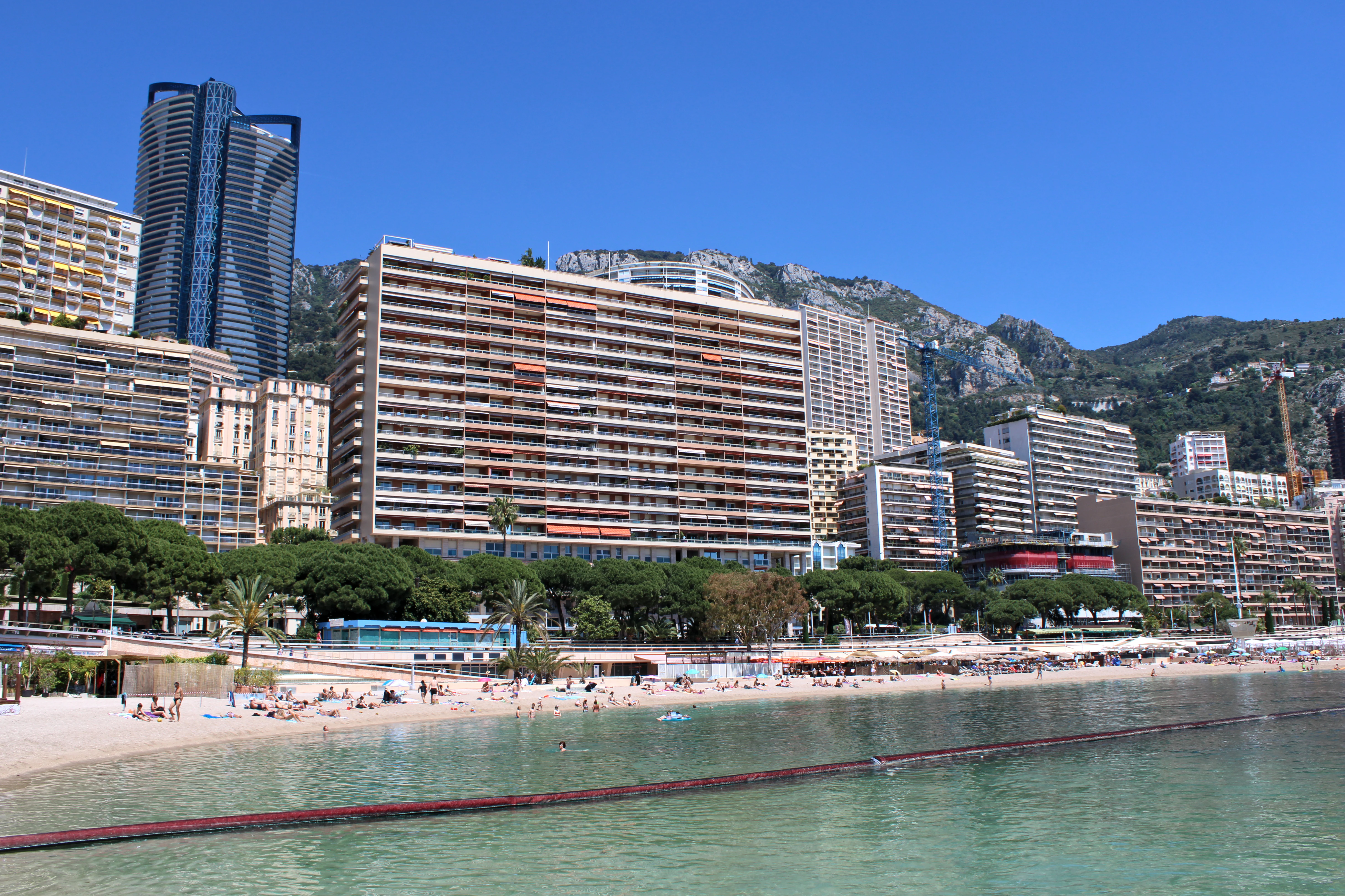
A wide angle view of the Larvotto beach in Monaco, featuring a sandy beach, clear water, and a dense backdrop of residential high rise buildings against a clear blue sky.
The Larvotto beach area in Monaco, showing the coastline and adjacent urban development.

Larvotto and Portier Coastal Reserve history and protected-area timeline

The Larvotto district expanded significantly in the early twenty-first century with the addition of Le Portier, a neighborhood built on reclaimed land along the sea and opened to the public in 2024. This expansion increased the district's surface area from about 21.8 hectares to 27.5 hectares and reshaped the surrounding marine environment.

Before and during this reclamation, conservation authorities prepared the seabed by transplanting Posidonia seagrass plates and lithophilic rocks to the Larvotto seabed at the end of 2016. Around 47 large nacres were also relocated to the same area. These actions laid the groundwork for what would later be formalized as the Larvotto and Portier Coastal Reserve, a Ramsar zone of about 0.23 square kilometers.

The reserve was conceived not only to conserve habitat but also to mitigate the impact of reclamation on the existing marine ecosystem. By relocating key habitat-forming species and substrates, the project sought to preserve the ecological functions of the nearshore zone. Today, the reserve's history is closely intertwined with the broader modern development of Monaco's eastern coastline, including the Grimaldi Forum, Avenue Princesse Grace, and the high-rise residential and hotel infrastructure that defines the Larvotto waterfront.

Its formal recognition as a Ramsar zone places the reserve within the global wetland conservation framework established under the Ramsar Convention, lending international visibility to a protected area that, by national standards, is extremely small yet ecologically significant.

Larvotto and Portier Coastal Reserve landscape and geographic character

The landscape of the Larvotto and Portier Coastal Reserve is defined less by dramatic topography and more by the subtle geomorphology of a Mediterranean shoreline pressed against urban development. The reserve's underwater scene includes a rocky seabed in the western portion, dropping to approximately ten meters; this substrate provides hard ground for sessile organisms and shelter for small fish communities.

In the eastern part of the reserve, the coast transitions into sandy beaches fronted by artificial rocky protection works rather than fully natural cliffs or coves. These engineered structures, while human-made, have been colonized by marine life and now serve as both coastal defense and habitat. The most visually and ecologically prominent feature of the reserve, though often invisible from the surface, is the Posidonia oceanica meadow, whose long, ribbon-like leaves form dense underwater prairies and give the nearshore zone its quiet, meadow-like character.

Above water, the reserve sits within the visual context of Monaco's eastern waterfront: the Larvotto promenade, Avenue Princesse Grace, the Grimaldi Forum, and the high-rise silhouettes of the Monte-Carlo Bay Hotel & Resort and the Roccabella tower. The juxtaposition of a Ramsar-listed marine reserve with one of the world's most expensive residential streets underscores the reserve's unusual character: a protected ecological zone embedded in an intensely developed Mediterranean coastline.

The combination of engineered coastal structures, transplanted habitat materials, and natural Mediterranean seagrass communities gives the reserve a hybrid landscape, one that is simultaneously built and biological, urban and wild.

Larvotto and Portier Coastal Reserve ecosystems, habitats, and plant life

The reserve's natural character is anchored in Mediterranean coastal and marine ecosystems that have been heavily compressed by urbanization elsewhere along the Riviera. Its principal habitat is the Posidonia oceanica meadow, a climax seagrass community that is highly valued across the Mediterranean for its role in oxygenating water, stabilizing the seabed, and providing shelter for juvenile fish and invertebrates.

Alongside the Posidonia meadows, the reserve's transplanted lithophilic rocks provide hard substrate that supports encrusting algae, sponges, and other benthic organisms. The deliberate relocation of approximately 47 large nacres further enhanced the benthic community by introducing filter-feeding mollusks that contribute to local water quality and ecological complexity. Together these elements create a habitat mosaic: soft seabed in some areas, structured rocky habitat in others, and a living meadow that integrates them.

Although Posidonia meadows occur elsewhere in the Mediterranean, they are increasingly fragmented and threatened by coastal development, anchoring, and pollution. The Larvotto and Portier Coastal Reserve preserves a functioning example of this habitat within one of the most densely populated and built coastlines in the region, making its ecological role disproportionately important for the surrounding marine environment.

Larvotto and Portier Coastal Reserve wildlife and species highlights

The reserve functions primarily as a refugium for native Mediterranean coastal fish species, which benefit from the structural complexity provided by rocky substrates and the dense, sheltering foliage of the Posidonia oceanica meadows. By concentrating habitat in a small area closed to broad recreational use, the reserve gives local fish populations a protected zone where recruitment and survival can proceed with reduced pressure from tourism, anchoring, and shoreline disturbance.

The benthic community includes associated invertebrates such as sponges, encrusting and turf algae, and the translocated nacres. Although the reserve is too small and too urban to host large charismatic marine fauna, its ecological importance lies in supporting the foundational species and habitat structures on which broader coastal food webs depend.

Its role as a base for numerous scientific studies further amplifies its wildlife significance: researchers use the reserve to monitor the health of Mediterranean coastal ecosystems, the persistence of transplanted habitat, and the recovery of fish communities in a heavily urban setting.

Larvotto and Portier Coastal Reserve conservation status and protection priorities

From a conservation perspective, the Larvotto and Portier Coastal Reserve is notable less for its size than for what it represents: a Ramsar-listed protected area embedded in a Mediterranean coastline under extreme urban pressure. Its designation as a Ramsar zone places Monaco on the international wetland conservation map and commits authorities to managing the site according to established wetland conservation principles.

The reserve's conservation value is enhanced by the active mitigation work undertaken during the Le Portier land reclamation project. The transplantation of Posidonia plates, lithophilic rocks, and 47 large nacres to the Larvotto seabed at the end of 2016 represents a deliberate effort to compensate for habitat loss in one marine zone by enhancing habitat in another. This kind of compensatory habitat creation is increasingly important in Mediterranean coastal management, where real estate and infrastructure expansion frequently clash with fragile nearshore ecosystems.

The closure of the reserve's waters to general tourism and recreational use concentrates human activity on nearby beaches rather than inside the protected zone, where access is reserved for environmental education and scientific study. This separation of recreational and conservation functions helps preserve water quality, minimize physical disturbance to the seabed, and maintain the reserve as a usable baseline for Mediterranean coastal research.

Larvotto and Portier Coastal Reserve cultural meaning and human context

The reserve's cultural context is inseparable from the identity of the wider Larvotto district, which is internationally recognized for its luxury residences, its position along Avenue Princesse Grace, and its proximity to the Monte Carlo quarter. Larvotto itself is Monaco's most populated ward and the principality's second-largest district by area, anchored by the Grimaldi Forum, the Sporting Monte-Carlo, and the Larvotto promenade.

Within this high-profile setting, the reserve adds an unexpected ecological dimension to a coastline that is more commonly associated with property prices, glamorous hotels, and Formula 1 imagery than with marine habitat protection. The reserve also reflects Monaco's broader efforts to balance territorial expansion with environmental commitments, signaling an awareness that even a small coastal footprint carries regional ecological responsibility.

Although the reserve lacks the long indigenous or rural heritage of larger national parks, its existence as a Ramsar zone in one of the world's most densely populated sovereign states gives it a distinct cultural resonance, framing it as a deliberate choice by Monaco to integrate ecological preservation into its coastal identity.

Top sights and standout views in Larvotto and Portier Coastal Reserve

A Ramsar-listed Mediterranean coastal reserve covering roughly 0.23 square kilometers along Monaco's eastern waterfront.

Contains one of the most intact Posidonia oceanica meadows along the urbanized Larvotto shoreline, with transplanted seagrass mats and lithophilic rocks that were relocated during the Le Portier reclamation project.

Acts as a refuge for native Mediterranean fish species and as a long-term site for marine research and limited environmental education, with recreational access restricted from the protected waters themselves.

Embodies an unusual conservation model: a formally protected marine zone integrated into one of the world's most densely developed and economically valuable coastlines.

Best time to visit Larvotto and Portier Coastal Reserve

As a strictly protected marine reserve with restricted public access, the Larvotto and Portier Coastal Reserve is not a casual visitor destination; most interactions occur indirectly through the adjacent Larvotto Beach and promenade, or through organized educational and scientific programs. Seasonality therefore matters less for entry than for surface-level appreciation.

Late spring through early autumn offers the warmest sea conditions and the clearest water along the Riviera, which is generally the most favorable period for snorkeling, diving, and observing Mediterranean marine life in nearby accessible areas. Calm, dry summer days also tend to provide the best visibility for viewing Posidonia meadows from the surface.

Winter and early spring bring cooler water temperatures and sometimes reduced visibility due to runoff and storms, conditions that are less favorable for casual marine observation but are often used by researchers monitoring seasonal changes in seagrass health and fish populations. Because the reserve itself limits tourist activity, prospective visitors should generally plan to experience the surrounding Larvotto waterfront and beach rather than entering the protected waters directly.


Monthly climate preview

Long-term representative monthly temperature and precipitation data for Monaco protected geography

Larvotto and Portier Coastal Reserve Climate Normals and Annual Weather Patterns

Representative coordinate measurements reveal annual temperature swings and monthly precipitation distributions across the protected landscape. Detailed multi-month climate records provide deeper baseline context for the protected area.
Annual mean17 °C
11 °C24 °C
Jan11°
Feb11°
Mar12°
Apr14°
May17°
Jun21°
Jul24°
Aug24°
Sep21°
Oct18°
Nov14°
Dec12°
Warmest month
August

24.2 °C

Coolest month
February

10.5 °C

Wettest month
November

3.8 mm/day

Driest month
July

0.5 mm/day

Park location guide

Geography guide, regional context, and park location map for Larvotto and Portier Coastal Reserve

Larvotto and Portier Coastal Reserve park geography, regions, and map view in Monaco

Understand where Larvotto and Portier Coastal Reserve sits in Monaco through a broader geographic reading of the surrounding landscape, nearby location context, and its mapped position within the national park landscape.

How Larvotto and Portier Coastal Reserve fits into Monaco

Monaco is a principality and microstate located on the Mediterranean coast of Western Europe. It is a semi-enclave within France and is one of the smallest sovereign states in the world. The country is famous for its upscale casinos, luxury real estate, and high population density. Monaco operates as a semi-constitutional monarchy under Prince Albert II, with French providing the official language.

Wider geography shaping Larvotto and Portier Coastal Reserve in Monaco

Monaco occupies a 2.08 km² area on the Mediterranean coast at the eastern end of the French Riviera. It is a semi-enclave completely surrounded by France, with the Italian region of Liguria approximately 15 km to the east. The territory is characterized by its coastal position along the Mediterranean Sea, with France bordering it to the north, east, and west. Monaco has the shortest national coastline of any non-landlocked nation at 3.83 km.

Map view of Larvotto and Portier Coastal Reserve

Use this park location map to pinpoint Larvotto and Portier Coastal Reserve in Monaco, understand its exact geographic position, and read its mapped placement within the surrounding landscape more clearly.

Pigeon | © OpenStreetMap contributors

Visualizing the marine landscapes, habitats, and urban shoreline context

Larvotto and Portier Coastal Reserve Photos and Scenery

Visual documentation reveals the unique marine environment, rocky seabed formations, and coastal habitats protected within the reserve. Examining these photographic records helps visitors understand how natural seagrass meadows integrate with the surrounding urban waterfront of Monaco.

A wide angle view of the Larvotto beach in Monaco, featuring a sandy beach, clear water, and a dense backdrop of residential high rise buildings against a clear blue sky.

Park atlas

Discover related protected areas and coastal landscapes across the surrounding region

Other Parks Near Larvotto and Portier Coastal Reserve for Regional Comparison

Compare Larvotto and Portier Coastal Reserve with other protected coastal zones and marine habitats in the surrounding Mediterranean territory. Regional park comparison reveals broader ecological patterns across intensely developed urban shorelines.
Marine protected areaFrance
About 0.1 km away#1 closest

Southeast

Sanctuaire Pelagos Marine Protected Area: Mediterranean Geography and Seascape

A transboundary conservation zone spanning 87,500 square kilometers.

Sanctuaire Pelagos represents a unique collaborative effort in marine conservation across the Mediterranean. Spanning the waters between France, Italy, and Monaco, this protected maritime area is defined by its deep-sea canyons and nutrient-rich currents that sustain diverse cetacean populations. Its immense scale and international governance make it a focal point for understanding Mediterranean marine biodiversity and environmental policy.

Area
87,500 km²
Established
1999
IUCN
IV
Relief
Lowland
Watercolor painting of distant purple hills and foreground pine trees in soft washes of green, yellow, and red on a white background.
State or regional parkProvence-Alpes-Côte d'Azur
About 11 km away#2 closest

West

Parc naturel départemental du Vinaigrier: Protected Limestone Landscapes near Nice

Regional state park with diverse Mediterranean woodland ecosystems

Parc naturel départemental du Vinaigrier offers a dense, 25 hectare mosaic of limestone plateaus and slopes near the Mediterranean coast. Its landscape is defined by traditional dry stone terraces and a rare flowering ash forest, creating a significant ecological bridge between the urban expansion of Nice and the hilly interior of the Alpes-Maritimes.

Area
0.25 km²
Established
1980
IUCN
IV
Watercolor illustration of a mountainous landscape featuring a river, rolling hills, and green vegetation
National parkFrance
About 18 km away#3 closest

Northwest

Mercantour National Park: Mapped Alpine Protected Landscape and Regional Geography

Explore France's dramatic Alps, park boundaries, and unique ecotones.

Mercantour National Park stands as a premier protected area within the French Alps, distinguished by its remarkable geographic diversity and ecological significance. This national park encompasses mountainous terrain featuring dramatic peaks, deep glacial valleys, and a unique ecotone where Mediterranean and Alpine ecosystems converge. MoriAtlas facilitates a detailed atlas-style exploration of Mercantour National Park, highlighting its mapped protected boundaries, varied natural landscapes, and its pivotal role in regional geography and conservation efforts.

Area
679 km²
Established
1979
IUCN
II
Visitors
800K annual
Watercolor painting of a park landscape with a foreground pond, grassy areas, and rolling hills in the background.
State or regional parkProvence-Alpes-Côte d'Azur
About 28 km away#4 closest

Southwest

Parc de Vaugrenier: Regional Protected Area and Archaeological Landscape in France

Wetland habitats and historic trails in Alpes-Maritimes

Parc de Vaugrenier protects a diverse hundred-hectare expanse between Antibes and Villeneuve-Loubet. Its terrain bridges Mediterranean woodland and lush freshwater meadows, distinguished by a rare collection of exotic trees and remnants of the ancient Via Julia Augusta. This park provides a quiet geographic contrast to the surrounding coastal urbanization of the French Riviera.

Area
1 km²
Established
1995
Visitors
500K annual
Relief
Lowland
A soft watercolor illustration depicting a panoramic view of rolling green hills under a pale, warm sky with distant mountains.
State or regional parkProvence-Alpes-Côte d'Azur
About 28 km away#5 closest

West

Parc naturel départemental du Plan des Noves: Protected Landscapes and Regional Geography

Upland limestone plateau in the French Baous massif

Covering 904 hectares above the town of Vence, this park features a unique combination of Mediterranean woodlands, open pastoral mosaics, and historic agricultural terraces. The terrain serves as a vital ecological corridor, recognized for its birdlife and reptiles, while its elevation offers expansive vistas across the surrounding regional geography from the coast to the high mountain summits.

Area
9.04 km²
Established
1987
Relief
Upland
Scope
Terrestrial
State or regional parkAlpes-Maritimes
About 36 km away#6 closest

West

Parc naturel départemental de l'Estéron: Riverside Geography in Alpes-Maritimes

A departmental park focusing on the wild Estéron River corridor

Located in the hinterland of the Côte d'Azur, Parc naturel départemental de l'Estéron provides a protected environment focused on the Estéron river valley. Its geography encompasses sun-exposed Mediterranean hillsides and riparian zones, reflecting the intersection of mountain terrain and historic cross-border heritage in the Alpes-Maritimes department.

Area
0.2 km²
Established
2011
Scope
Terrestrial
Water
Major water bodies
A soft watercolor painting of a coastal landscape with rolling hills, distant mountains, and green vegetation against a light sky.
Marine protected areaProvence-Alpes-Côte d'Azur
About 47 km away#7 closest

Southwest

Parc maritime départemental Estérel-Théoule: Marine Protected Area and Coastal Geography

A vital Mediterranean corridor along the French Riviera coast

This marine protected area preserves a unique underwater mosaic where rocky shallows, sandy patches, and Posidonia seagrass meadows converge. Located offshore from the Estérel massif, the site provides a continuous conservation corridor between inland natural spaces and the Mediterranean Sea, offering insight into the littoral environment of the French Riviera.

Area
3.5 km²
Water
Water-dominated
Season
Seasonal
A watercolor illustration showing a landscape with red rock formations, green vegetation, and a winding blue river.
Nature reserveProvence-Alpes-Côte d'Azur
About 58 km away#8 closest

Northwest

Réserve naturelle régionale des gorges de Daluis: Red Rock Canyon and Geological Atlas

Protected canyon landscape in Provence-Alpes-Côte d'Azur

Defined by its vivid red pelite cliffs, Réserve naturelle régionale des gorges de Daluis functions as a significant protected canyon system. The terrain preserves rare mineralogy and diverse microhabitats, ranging from river-carved walls to upland slopes that support unique regional biodiversity in the Alpes-Maritimes.

Area
10.82 km²
Established
2012
IUCN
IV
Relief
Mountain

Common questions about visiting, size, designation, and location context for Larvotto and Portier Coastal Reserve

Larvotto and Portier Coastal Reserve FAQs for park facts, access, geography, and protected area context

Find quick answers about Larvotto and Portier Coastal Reserve, including protected-area facts, park geography, trail and visitor context, and how the park fits into its surrounding country and regional landscape.
MoriAtlas Explorer

Continue Your Protected Areas Search Across the Global Atlas

Deepen your exploration by continuing the structured search for national parks and protected areas worldwide. Utilize the comprehensive filtering capabilities to compare different conservation landscapes and refine your understanding of global park geography. Discover more about the distribution and characteristics of protected natural areas.

Global natural geography