
Mori Atlas logo
Nature reserveLaubenheimer-Bodenheimer Ried

Discover the intricate geography of Rhine flood channels, rare botanical communities, and thriving bird populations within this essential German nature reserve.

Laubenheimer-Bodenheimer Ried Nature Reserve in Rhineland-Palatinate: A Detailed Atlas of Protected Floodplain Landscapes

(Naturschutzgebiet Laubenheimer-Bodenheimer Ried)

The Laubenheimer-Bodenheimer Ried nature reserve represents an essential ecological mosaic situated within the Upper Rhine Lowlands of Rhineland-Palatinate. This protected area preserves a complex transition of former clay pits, silted flood channels, and embankment meadows that support more than 630 vascular plant species. Visitors and researchers can utilize this map-based overview to examine the reserve's unique halophytic communities, the regionally significant Iris spuria population, and the accessible white stork colony nesting on local infrastructure.

floodplainRhineland-PalatinateUpper Rhinenature reservewet meadowreedbed
A flat-style digital illustration depicting a mountain valley with a winding river, a waterfall flowing from a cliff, and surrounding evergreen forests under a soft, light-colored sky.

Laubenheimer-Bodenheimer Ried

Nature reserve

Park overview

Structured park overview, official facts, and landscape profile for Laubenheimer-Bodenheimer Ried

Laubenheimer-Bodenheimer Ried park facts, protected area profile, and essential visitor context

Review the core facts for Laubenheimer-Bodenheimer Ried, including designation, size, terrain, visitor scale, habitats, and operating context in one park-focused overview.

About Laubenheimer-Bodenheimer Ried

The Laubenheimer-Bodenheimer Ried is a protected floodplain landscape in the Bodenheimer Aue, located in the Upper Rhine Lowland between the city of Mainz and the Rhine. Today it encompasses roughly 180 hectares, combining former clay extraction pits, abandoned flood channels of the Rhine, and traditionally used agricultural land. Over time these varied land uses have produced a mosaic of small lakes, ponds, ditches, reedbeds, wet meadows, and half-dry grasslands, all tightly interwoven within a compact reserve.

Ecologically, the area stands out for combining high species richness with a remarkable concentration of rare and threatened habitat types. More than 630 vascular plant species have been documented, including specialized floodplain meadow communities, halophytes that are otherwise rare in Rhineland-Palatinate, and regionally important populations of Iris spuria on the embankments. The reserve also hosts a diverse bird community, with species such as bluethroat, kingfisher, reed warblers, marsh harrier, spotted crake, and little bittern relying on its open waters, reedbeds, and meadows.

From a protection standpoint, the area benefits from multiple overlapping designations. It is a German Naturschutzgebiet and is recognized as an FFH area under the European Habitats Directive, with the city of Mainz noting that these multiple protection categories underline the special and irreplaceable value of the site for local flora and fauna. The reserve's management emphasizes the preservation of floodplain topography, the maintenance of fluctuating moisture conditions, and the safeguarding of extensive grassland on wet, seasonally flooded, and drier substrates.

Quick facts and research context for Laubenheimer-Bodenheimer Ried

The Laubenheimer-Bodenheimer Ried lies near the Rhine on the territory of Mainz and the surrounding Mainz-Bingen district. It was first designated as a nature reserve in 1982 covering about 71 hectares and was expanded in 1998 to approximately 180 hectares. The area is also classified as a European FFH site, giving it protection status beyond the German nature reserve designation.

The landscape is shaped by floodplain features: former clay pits, silted Rhine channels, agricultural meadows, and flood dikes that create a step from wet to dry habitats within a small area. The reserve supports a distinctive flora including halophytes rare in Rhineland-Palatinate, orchid-like wetland species such as Iris spuria, and species-rich Stromtalwiesen, while also being a key refuge for threatened wetland birds.

Protection and recognition

Documented terrestrial protection scope, 1998 designation year, and official recognition records

Laubenheimer-Bodenheimer Ried Protection Status and Official Designation History

Laubenheimer-Bodenheimer Ried holds documented terrestrial protection status established in the designated year 1998. Official conservation records outline the administrative management scope and recognized territorial boundaries for this protected area.

Protection details

Protection scope
Terrestrial
Designated year
1998
Transboundary protection
No
WDPA ID
164388
Park context

Deeper park guide and search-rich context for Laubenheimer-Bodenheimer Ried

Laubenheimer-Bodenheimer Ried history, landscape, wildlife, and travel context

Explore Laubenheimer-Bodenheimer Ried through its history, landscape character, ecosystems, wildlife, conservation priorities, cultural context, and seasonal travel timing in a structured park guide built for atlas discovery and search intent.

Why Laubenheimer-Bodenheimer Ried stands out

The reserve is best known for its exceptionally diverse floodplain flora and its accessible white stork colony, where multiple pairs breed simultaneously on electricity pylons that cross the wetland. It is also recognized as one of the most important sites in Germany for the blue-flowering Iris spuria, whose strongest population occurs here on the half-dry grasslands of the flood dikes. Equally important is its ecological mosaic: a small area where clay-pit pools, silted Rhine channels, reedbeds, wet meadows, and embankment grasslands combine to create a textbook floodplain landscape. This habitat complexity supports rare breeding birds, halophytic plant communities that are otherwise absent in Rhineland-Palatinate, and species-rich Stromtalwiesen of high conservation priority.
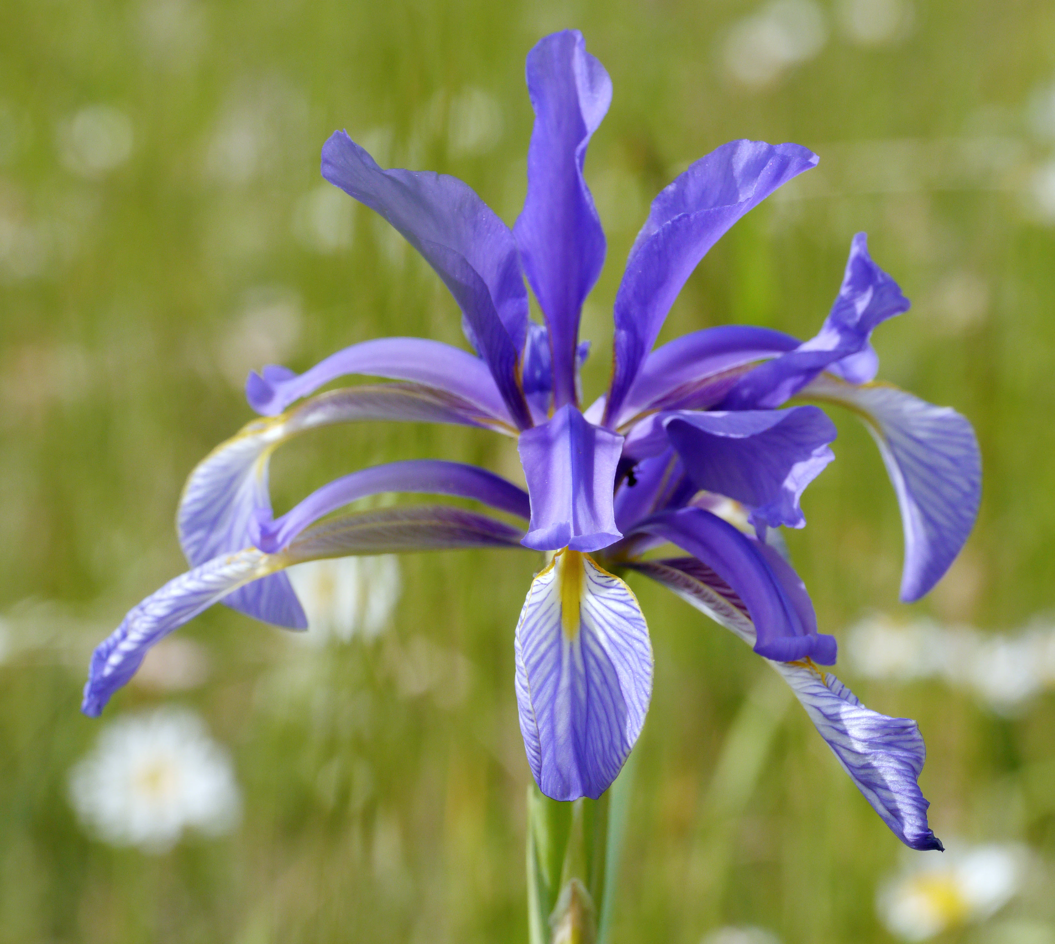
A close-up photograph of a bright purple Iris spuria flower with a yellow and white veined center against a soft-focus green meadow.
A detailed view of an Iris spuria flower, a species found in the Laubenheimer-Bodenheimer Ried nature reserve.

Laubenheimer-Bodenheimer Ried history and protected-area timeline

The Laubenheimer-Bodenheimer Ried was first protected in 1982, when about 71 hectares were designated as a nature reserve by legal ordinance to preserve its meadows, reedbeds, ponds, and associated threatened plant and animal species. The original protection purpose focused particularly on safeguarding the rich and endangered birdlife of the open water and reed habitats, along with the botanical value of the floodplain landscapes.

In 1998, the reserve was significantly expanded through a follow-up ordinance, the Erweiterung Laubenheimer-Bodenheimer Ried, bringing the total protected area to roughly 180 hectares. The expanded designation added explicit goals of preserving and restoring the characteristic floodplain surface, maintaining the natural alternation between wet and moist conditions, and protecting species-rich Stromtal meadows, wet meadows, near-natural flood channels, small water bodies, and certain low-intensity cropland areas.

Over the following decades, the area's importance grew beyond the regional scale, as it became recognized as an FFH site under the European Union's Habitats Directive. This layered designation reflects an evolving understanding of the reserve's irreplaceable value for threatened floodplain species and habitats, and continues to shape its management today.

Laubenheimer-Bodenheimer Ried landscape and geographic character

The reserve sits in the broad, flat floodplain of the Upper Rhine, where the landscape is shaped less by dramatic relief than by subtle transitions between water, wetland, and grassland. Former clay pits and old, silted flood channels of the Rhine have left behind a network of small lakes, ponds, and shallow depressions that fill and drain with the seasons. Around them lie wet meadows, reedbeds, and taller marsh vegetation, while slightly elevated embankments along the flood dikes support drier, half-dry grassland communities.

These contrasting conditions are packed into a relatively small area, producing visible shifts in vegetation over short distances: from open water and reed edges, through waterlogged meadows, to flower-rich embankment grasslands higher up on the dikes. The result is a classic Auenlandschaft, or floodplain landscape, where the memory of the Rhine's historical movements is still legible in the pattern of channels, pools, and meadows.
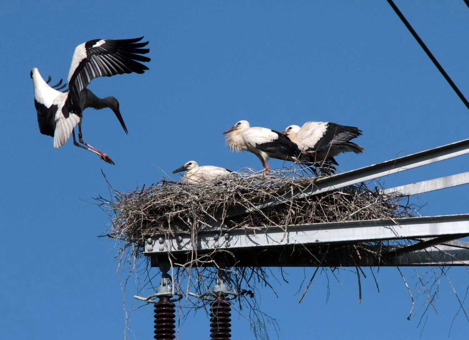
A white stork landing in a large twig nest built on a metal utility structure, with three other storks already sitting in the nest against a clear blue sky.
White storks nesting on a utility pole in Laubenheimer-Bodenheimer Ried.

Laubenheimer-Bodenheimer Ried ecosystems, habitats, and plant life

Ecologically, the Laubenheimer-Bodenheimer Ried is defined by the interweaving of aquatic, wetland, and dry grassland habitats typical of large river floodplains. The pools and silted channels support rich emergent vegetation, while the meadows and ditches are managed as extensive grassland to maintain their botanical value. The flood dikes, in particular, harbor a distinctive community of Stromtal-Halbtrockenrasen, a type of half-dry grassland associated historically with the warm, dry valley of the Upper Rhine.

The reserve's botanical richness is unusually high for its size. More than 630 vascular plant species have been recorded, reflecting the convergence of wet, moist, and dry conditions in a single landscape. Notable elements include species-rich Stromtalwiesen along the flood channels with characteristic plants such as Cnidium dubium, Allium angulosum, Scutellaria hastifolia, Serratula tinctoria, and Euphorbia palustris. The presence of numerous halophytes, or salt-tolerant plants, along path edges is unique within Rhineland-Palatinate and reflects the area's unusual substrate and hydrological history.

Above all, the reserve is famous regionally for the mass blooming of the rare blue-flowering Iris spuria on the dike grasslands, a species that in Germany is essentially restricted to Rheinhessen and finds its most significant population here.
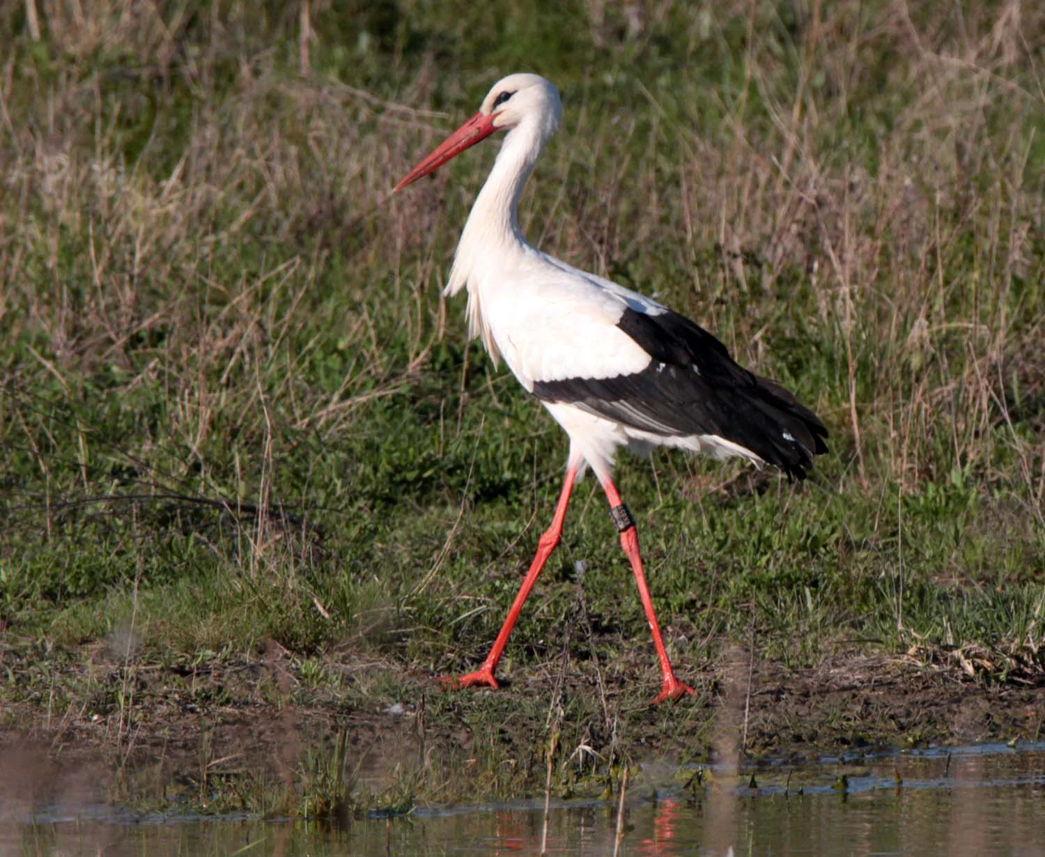
A white stork with black-tipped wings and long red legs walking through grassy marshland by the water's edge.
A white stork walking through the wetlands of the Laubenheimer-Bodenheimer Ried nature reserve.

Laubenheimer-Bodenheimer Ried wildlife and species highlights

The reserve supports a notably rich bird community tied to its combination of open water, reedbeds, and meadows. Threatened species such as bluethroat, kingfisher, various reed warblers, marsh harrier, spotted crake, and little bittern are recorded here, with several of these species relying in Rhineland-Palatinate on the remaining suitable habitats along the Upper Rhine.

The most visible wildlife attraction is the regularly breeding white stork colony, which nests on electricity pylons that cross the wetland. Multiple pairs often nest in close proximity on the same pylons, and some individuals return to the same nesting sites year after year. This dense stork presence has become a signature feature of the reserve and a popular focus for visitors interested in wetland birds.

Beyond birds, the mosaic of habitats supports a wide range of invertebrates, mollusks, and other fauna documented in regional studies of the area, contributing to its broader ecological importance as a refuge of floodplain biodiversity.

A large metal electrical pylon with multiple stork nests built on the crossarms, with adult storks visible at the nests against a clear sky.
White storks nesting on an electrical pylon within the Laubenheimer-Bodenheimer Ried nature reserve.

Laubenheimer-Bodenheimer Ried conservation status and protection priorities

The Laubenheimer-Bodenheimer Ried holds a particularly strong conservation profile due to its layered protection status. Beyond its designation as a German Naturschutzgebiet, it is recognized as an FFH area under the European Union's Habitats Directive, placing it among the highest-profile protected floodplain sites in Rhineland-Palatinate. Officials in Mainz have emphasized that the area is subject to multiple overlapping protection categories, underlining its special and irreplaceable value for local flora and fauna.

Its conservation significance rests on three pillars. First, the reserve protects a floodplain topography and the natural alternation of wet, moist, and dry conditions that are now rare along highly regulated rivers. Second, it preserves extensive grassland habitats of high botanical value, including Stromtal meadows and dike grasslands that would otherwise be lost to intensification or abandonment. Third, it serves as a critical refuge for threatened species of plants, birds, and other fauna, several of which depend on the Upper Rhine as one of their last regional strongholds.

Management efforts focus on maintaining the area's hydrological diversity, preserving traditional extensive grassland use, and protecting especially sensitive breeding sites such as the stork colony on the pylons.

Laubenheimer-Bodenheimer Ried cultural meaning and human context

The Laubenheimer-Bodenheimer Ried lies at the interface of the city of Mainz and the rural Mainz-Bingen district, occupying the historical floodplain that has long been shaped by human activity along the Rhine. The presence of former clay pits reflects centuries of small-scale extraction, while the network of channels and dikes testifies to the long history of flood management and agricultural use of the Auenlandschaft.

The area's traditional meadows and low-intensity land use represent a continuation of regional floodplain farming practices, and its current protection reflects a broader cultural shift toward recognizing the Rhine floodplains as ecological heritage rather than purely productive land. The stork colony on the pylons has also become part of the local identity of Mainz-Laubenheim and Bodenheim, drawing visitors and connecting the reserve to wider regional traditions of stork-centered rural landscapes in the Rhine valley.
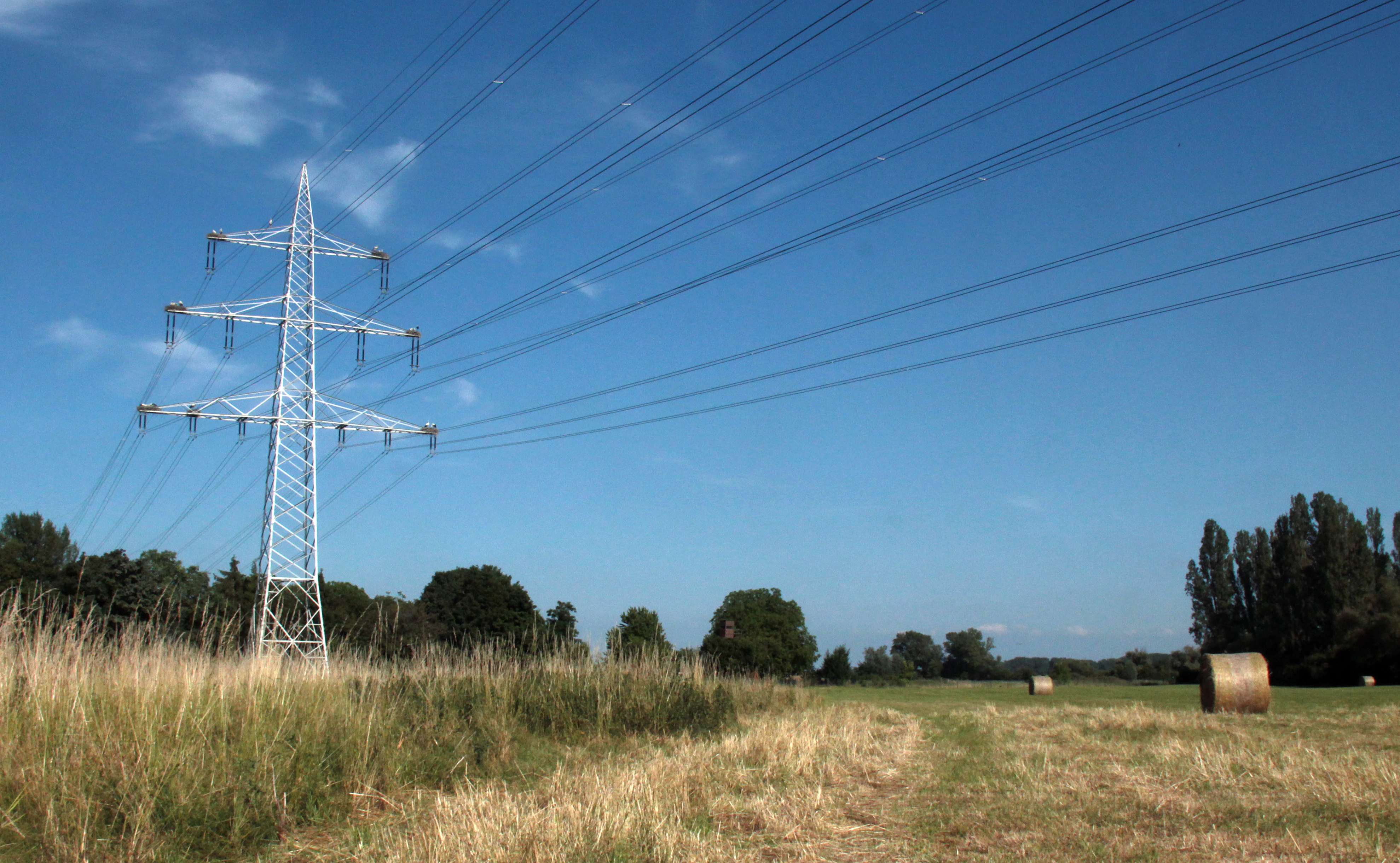
A metal high-voltage electricity transmission tower stands in a grassy field with round hay bales, under a clear blue sky.
A metal power pole in Laubenheimer-Bodenheimer Ried, which serves as a nesting site for storks.

Top sights and standout views in Laubenheimer-Bodenheimer Ried

Among the reserve's most distinctive features is the visible layering of protection: a German nature reserve combined with European FFH status, recognizing the area's importance for threatened species and habitat types. Its botanical record is exceptional, with more than 630 vascular plant species, halophytic communities unique in Rhineland-Palatinate, and the country's most important population of Iris spuria on the dike grasslands.

At the same time, the reserve offers an unusually accessible wildlife spectacle through its white stork colony on the electricity pylons, where multiple pairs breed in plain view of visitors. Combined with the compact floodplain mosaic of pools, channels, reedbeds, meadows, and embankments, this makes the Laubenheimer-Bodenheimer Ried a textbook example of an Upper Rhine floodplain landscape.

Best time to visit Laubenheimer-Bodenheimer Ried

Late spring into early summer is generally the most rewarding period to experience the reserve, when the blue blooms of Iris spuria cover the dike grasslands and the wet meadows reach their full botanical diversity. This is also the core of the breeding season for many of the wetland birds, including the white stork colony on the pylons.

Late summer and early autumn offer quieter conditions with warm, dry weather suited to walking the dikes and observing the varied vegetation along the flood channels. Winter can bring its own character, with flooded fields and resting waterfowl, though the reserve's breeding bird highlights are no longer present, and access may be limited by seasonal conditions or management periods.


Monthly climate preview

Long-term representative monthly temperature and precipitation data patterns

Laubenheimer-Bodenheimer Ried Climate Normals and Annual Temperature Rhythm

Historical NASA Power climatology records outline the measured monthly temperature progression and precipitation rhythm across Laubenheimer-Bodenheimer Ried. Examining the full twelve-month profile provides deeper context for long-term meteorological patterns at this representative coordinate.
Annual mean9 °C
0 °C20 °C
Jan
Feb
Mar
Apr
May13°
Jun17°
Jul20°
Aug19°
Sep15°
Oct
Nov
Dec
Warmest month
July

19.6 °C

Coolest month
January

-0.1 °C

Wettest month
July

2.2 mm/day

Driest month
April

1.5 mm/day

Park location guide

Geography guide, regional context, and park location map for Laubenheimer-Bodenheimer Ried

Laubenheimer-Bodenheimer Ried park geography, regions, and map view in Germany

Understand where Laubenheimer-Bodenheimer Ried sits in Germany through a broader geographic reading of the surrounding landscape, nearby location context, and its mapped position within the national park landscape.

How Laubenheimer-Bodenheimer Ried fits into Germany

Germany is a federal republic in Western and Central Europe with a population of over 83 million across sixteen constituent states. It is Europe's largest economy by nominal GDP and a major global exporter and importer. The capital is Berlin, and the country borders Denmark, Poland, Czech Republic, Austria, Switzerland, France, Luxembourg, Belgium, and the Netherlands.

Wider geography shaping Laubenheimer-Bodenheimer Ried in Germany

Germany is located in Western and Central Europe, spanning 357,022 km². It borders Denmark to the north, Poland and the Czech Republic to the east, Austria and Switzerland to the south, and France, Luxembourg, Belgium, and the Netherlands to the west. The country has coastlines on the Baltic Sea and North Sea to the north, with the Alps located in the southern region.

Map view of Laubenheimer-Bodenheimer Ried

Use this park location map to pinpoint Laubenheimer-Bodenheimer Ried in Germany, understand its exact geographic position, and read its mapped placement within the surrounding landscape more clearly.

Pigeon | © OpenStreetMap contributors

Location context for Laubenheimer-Bodenheimer Ried

Rhineland-Palatinate

Visual reference for floodplain habitats, wetlands, and reserve vegetation

Laubenheimer-Bodenheimer Ried Photos and Protected Landscape Scenery

Visual documentation captures the complex wetland mosaic, open pools, and riparian vegetation defining the Laubenheimer-Bodenheimer Ried reserve. Detailed photographs reveal subtle elevation shifts across flood dikes, embankment meadows, and diverse wildlife habitats within the Upper Rhine basin.

A close-up photograph of a bright purple Iris spuria flower with a yellow and white veined center against a soft-focus green meadow.

Two white storks standing in a large stick nest built on top of a metal electricity pylon against a clear blue sky.

A white stork landing in a large twig nest built on a metal utility structure, with three other storks already sitting in the nest against a clear blue sky.

A white stork with black-tipped wings and long red legs walking through grassy marshland by the water's edge.

A large metal electrical pylon with multiple stork nests built on the crossarms, with adult storks visible at the nests against a clear sky.

A small, still pond sits in a grassy wetland area with distant trees and power line towers visible under a light blue sky.

A metal high-voltage electricity transmission tower stands in a grassy field with round hay bales, under a clear blue sky.

Park atlas

Compare regional wetland habitats and connected protected areas across the Upper Rhine

Parks Near Laubenheimer-Bodenheimer Ried and Surrounding Protected Landscapes

Continue exploring regional floodplain reserves, wet grasslands, and protected natural areas located near Laubenheimer-Bodenheimer Ried. Expanding the geographic comparison reveals broader habitat patterns across the surrounding Mainz lowland corridor.
A watercolor painting showing a soft, atmospheric landscape with a river flowing through green hills and gentle, misty mountains.
Nature reserveRhineland-Palatinate
About 5.2 km away#1 closest

North

Inselrhein Nature Reserve, Rhineland-Palatinate: A Geographic and Protected-Area Atlas

River islands, floodplain forests, and Upper Rhine wetlands

Inselrhein features a chain of natural river islands and side channels forming a critical wetland habitat. The terrain transition from soft-wood to hardwood forest communities creates a layered landscape. Examine the protected boundaries and geographic significance of this river corridor between Mainz and Bingen, documented within the Rhineland-Palatinate atlas.

Relief
Lowland
Climate
Temperate
Access
Easy access
Scope
Terrestrial
Nature reserveRhineland-Palatinate
About 10 km away#2 closest

West

Wiesen am Layenhof, Ober-Olmer Wald Nature Reserve: Mapped Landscapes of Rhineland-Palatinate

Protecting a delicate balance of beech woodland and rare dry grassland ecosystems.

Spanning 533 hectares near Mainz, this nature reserve serves as a critical refuge for biodiversity, characterized by its interlocking habitat types including oak-beech forests and orchid-rich dry swards. The geography is shaped by small seasonal pools and a network of pathways that provide access to the protected terrain, offering a clear view of how woodland and meadow habitats interact within the landscape of Rhineland-Palatinate.

Area
5.33 km²
Established
2017
Relief
Lowland
Scope
Terrestrial
A soft watercolor painting of a winding river flowing through a lush green floodplain with distant hills under a pale sky.
Nature reserveHessen
About 11 km away#3 closest

Southeast

Kühkopf-Knoblochsaue Nature Reserve: A Detailed Look at Hessian Rhine Floodplain Geography

Protected river island terrain, alluvial forests, and floodplain dynamics

Examine the geographic characteristics of Kühkopf-Knoblochsaue, the premier nature reserve in the Hessian Ried. This site provides an in-depth atlas perspective on the Rhine floodplain, featuring the iconic inland island structure, softwood and hardwood forest transitions, and the ongoing influence of the Stockstadt-Erfelder Altrhein on the local terrain.

Area
24.4 km²
Established
1952
Relief
Lowland
Climate
Temperate
A wide watercolor illustration showing a winding river flowing through a green floodplain with scattered trees and pale pink and purple hills in the distance.
Nature reserveHesse
About 12 km away#4 closest

Northwest

Rettbergsaue Nature Reserve: Geography and Protected Landscapes in the Rhine Valley

A vital river island ecosystem and floodplain forest in Hesse.

Rettbergsaue serves as an essential riverine habitat in the Upper Rhine. This nature reserve, characterized by its alluvial woodland and riparian meadows, offers a detailed study of sediment-formed islands and the interplay between main-channel water flow and sheltered side-arm environments within the state of Hesse.

Area
0.68 km²
Established
1978
Relief
Lowland
Climate
Temperate
Nature reserveHessen
About 12 km away#5 closest

East

Niederwald von Groß-Gerau Nature Reserve: Hessen Protected Woodland and Riparian Geography

A preserved lowland forest habitat in the Rhine-Main landscape

Niederwald von Groß-Gerau serves as a protected refuge for moist deciduous woodland in the Untermainebene. This nature reserve features an intricate network of streams and deadwood habitats, standing as a vital ecological link within the heavily developed region of Hessen. Explore the mapped boundaries and natural terrain of this unique, habitat-rich forest fragment.

Area
0.696 km²
Established
1995
IUCN
IV
Relief
Lowland
A soft watercolor painting of a forest landscape with slender trees, green grass, and distant rolling hills against a pale, warm sky.
Nature reserveRhineland-Palatinate
About 12 km away#6 closest

Northwest

Lennebergwald Nature Reserve: Mapped Geography and Protected Forest Landscapes in Germany

Rhineland-Palatinate woodland and dry forest ecosystem analysis

Analyze the Lennebergwald nature reserve through its geological and ecological profile. This protected area in Rhineland-Palatinate showcases a rare inland sand forest structure, linking together pine and oak stands with vital dry grassland habitats that form a critical ecological mosaic in central Germany.

Area
8 km²
Established
1996
Relief
Lowland
Climate
Temperate
A horizontal watercolor painting depicting a soft, rolling meadow with patches of trees and distant hills.
Nature reserveHessen
About 14 km away#7 closest

Southeast

Bruchwiesen bei Büttelborn Nature Reserve: Hessen Protected Wetland and River Meander

Mapped terrain and protected fen ecology in the Rhine Main region

Bruchwiesen bei Büttelborn represents a major protected lowland fen situated along a former course of the Neckar River. The site provides a mosaic of reedbeds, moist grasslands, and deciduous woodlands, creating a crucial habitat within the agricultural landscape of Hessen. This data highlights the park boundaries and the complex hydrological features that define this ecologically significant wetland.

Area
0.88 km²
Established
1997
IUCN
IV
Watercolor painting of a misty river landscape with green trees, reeds, and soft hills in the background.
Nature reserveHesse
About 14 km away#8 closest

Northwest

Niederwallufer Bucht Nature Reserve: Rhine Floodplain Landscape and Geographic Context

Protected riparian habitat in the state of Hesse

Niederwallufer Bucht represents a key example of a conserved Rhine riverbank environment. This nature reserve protects a delicate mix of soft-wood forests, sheltered backwater bays, and riparian meadows. By maintaining these wetlands against the backdrop of the heavily settled Rheingau, the site provides a vital node of ecological continuity and a clear look at floodplain terrain within central Germany.

Area
0.13 km²
Established
2000
IUCN
IV

Common questions about visiting, size, designation, and location context for Laubenheimer-Bodenheimer Ried

Laubenheimer-Bodenheimer Ried FAQs for park facts, access, geography, and protected area context

Find quick answers about Laubenheimer-Bodenheimer Ried, including protected-area facts, park geography, trail and visitor context, and how the park fits into its surrounding country and regional landscape.
MoriAtlas Explorer

Continue Your Protected Areas Search Across the Global Atlas

Deepen your exploration by continuing the structured search for national parks and protected areas worldwide. Utilize the comprehensive filtering capabilities to compare different conservation landscapes and refine your understanding of global park geography. Discover more about the distribution and characteristics of protected natural areas.

Global natural geography