
Mori Atlas logo
Nature reserveLewertbach mit Nebenbächen

A detailed geographic look at the brook system, pasturelands, and hedgerow habitats within the Nordeifel

Lewertbach mit Nebenbächen Nature Reserve: Protected Lowland Brook Landscape and Regional Geography

(Naturschutzgebiet Lewertbach mit Nebenbächen)

Lewertbach mit Nebenbächen encompasses a 71-hectare protected area in the Dahlem municipality of North Rhine-Westphalia. This nature reserve serves as a critical habitat for native species by preserving a complex of unhardened lowland streams, wet pasture margins, and organic woodland edges. The site illustrates the characteristic drainage patterns and terrestrial mosaic of the Nordeifel landscape, offering a clear view of how these small-scale aquatic and meadow systems function as interconnected habitats.

nature reservelowland brookstream valleypasture landscapehedgerowsNordeifel
An illustration showing a lush valley with a waterfall between tree-lined hills and distant mountains under a soft sky.

Lewertbach mit Nebenbächen

Nature reserve

Park overview

Structured park overview, official facts, and landscape profile for Lewertbach mit Nebenbächen Nature Reserve

Lewertbach mit Nebenbächen Nature Reserve park facts, protected area profile, and essential visitor context

Review the core facts for Lewertbach mit Nebenbächen Nature Reserve, including designation, size, terrain, visitor scale, habitats, and operating context in one park-focused overview.

About Lewertbach mit Nebenbächen Nature Reserve

Lewertbach mit Nebenbächen is a compact nature reserve in the Nordeifel region of western Germany, situated in the Dahlem municipality of the Euskirchen district in North Rhine-Westphalia. The protected area stretches across the western fringes of the core village of Dahlem, close to the border with Rhineland-Palatinate, and forms one element in a dense regional network of small brook and meadow reserves that together characterize the conservation landscape of this part of the Eifel.

The reserve was formally designated in 2001 and covers about 71 hectares, split into three separate parcels along the course of the Lewertbach and its small tributaries. The central landscape theme of the site is a natural, unmodified lowland stream system running through open pasture. There is no bank reinforcement or artificial bedding along the brooks; instead, the watercourses are accompanied by a network of small hedgerows and woody patches (Kleingehölze) that give structure to the otherwise open grazed meadows. This combination of soft, dynamic water edges, wet grassland fringe, and linear woody elements creates transition zones that are biologically rich and that the site was specifically designated to maintain.

Ecologically, the reserve is intended to protect habitat for several plant and animal species listed on the Red List of North Rhine-Westphalia. Typical meadow plants in the area include meadow-sweet (Echtes Mädesüß), cleavers (Kletten-Labkraut), eared willow (Ohr-Weide), reed canary grass (Rohrglanzgras) and the narrow-leaved willowherb (Schmalblättriges Weidenröschen). The clean, naturally flowing streams support freshwater fauna such as the common freshwater shrimp (Bachflohkrebs) and the large brook-running water beetle (Großer Bachläufer). The protected landscape is also intended to preserve the visual and structural role of these hedgerow networks within a wider farming landscape shaped by extensive grazing.

Quick facts and research context for Lewertbach mit Nebenbächen Nature Reserve

Lewertbach mit Nebenbächen is a nature reserve in Dahlem, Kreis Euskirchen, North Rhine-Westphalia, Germany, classified as an IUCN Category IV Habitat/Species Management Area. The designation was established in 2001, and the protected area comprises about 71 hectares across three parcels that follow the Lewertbach brook and several feeder streams.

The reserve lies near the state border with Rhineland-Palatinate and is part of the Nordeifel landscape of small stream valleys, managed pastures and hedgerow-patterned farmland. It is registered in the World Database on Protected Areas under ID 318729, and the FFH site identifier for the area is EU-066.

Protection and recognition

Documented protection history and official international recognition data

Lewertbach mit Nebenbächen Protection Status and Conservation Records

Lewertbach mit Nebenbächen maintains structured protection records detailing official conservation status and administrative boundaries. Formal recognition parameters provide clear reference points for evaluating environmental preservation frameworks.

Protection details

WDPA ID
318729
Park context

Deeper park guide and search-rich context for Lewertbach mit Nebenbächen Nature Reserve

Lewertbach mit Nebenbächen Nature Reserve history, landscape, wildlife, and travel context

Explore Lewertbach mit Nebenbächen Nature Reserve through its history, landscape character, ecosystems, wildlife, conservation priorities, cultural context, and seasonal travel timing in a structured park guide built for atlas discovery and search intent.

Why Lewertbach mit Nebenbächen Nature Reserve stands out

The reserve is best known for its small, unmodified brook system: the Lewertbach and its tributaries (Süsenbach, Füllenbach, Giesenbach and another unnamed stream) flow through open pastures that are structured by small hedgerows (Kleingehölze), without any hardening of banks or streambed. This combination of meandering, naturalistic watercourse and hedgerow-rich pasture landscape is the defining ecological and scenic feature of the site. It is also recognized for protecting Red List plant and animal species that depend on this combination of flowing fresh water, wet meadow margins and linear woody structures, making it a textbook example of a small-scale, ecologically valuable lowland stream landscape in the Nordeifel.
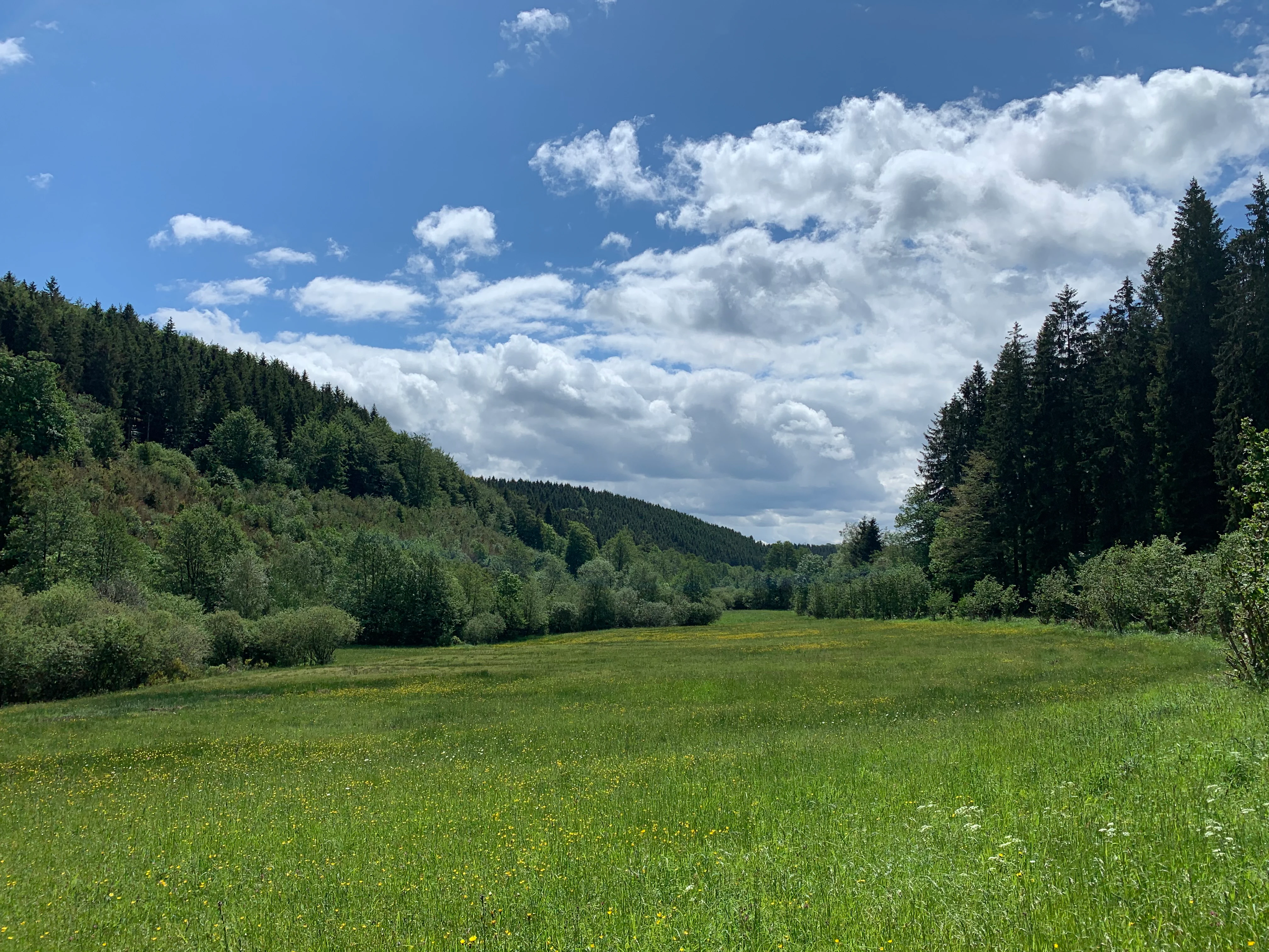
A wide, grassy meadow landscape framed by dense coniferous forest slopes under a bright blue sky with scattered clouds.
A green meadow landscape in the nature reserve Lewertbach mit Nebenbächen, Germany.

Lewertbach mit Nebenbächen Nature Reserve history and protected-area timeline

The area now protected as Lewertbach mit Nebenbächen was brought under formal protection in 2001, when the local designation as a Naturschutzgebiet (nature reserve) was put in place to secure the streams and grazed meadows for long-term conservation. The designation was driven by the presence of several plant and animal species listed on the North Rhine-Westphalian Red List, whose habitat depends on this combination of small brooks, wet grassland margins and hedgerow structures within an extensively grazed landscape.

Within the broader North Rhine-Westphalian system of protected areas, the reserve also carries an FFH designation under the code EU-066, marking its contribution to the EU Habitats Directive network. It is registered internationally in the World Database on Protected Areas under ID 318729. Subsequent management guidance has been provided by the Landesamt für Natur, Umwelt und Verbraucherschutz Nordrhein-Westfalen (LANUV), which continues to oversee its conservation and to monitor threats such as erosion, browsing damage to hedgerows, clearance of woody patches and trampling from livestock and visitors.

Lewertbach mit Nebenbächen Nature Reserve landscape and geographic character

The reserve belongs to the Nordeifel, a rolling, gently hilly landscape of low ridges, shallow valleys and small stream hollows that are characteristic of the border area between North Rhine-Westphalia and Rhineland-Palatinate. Elevations within and around the site are moderate, and the terrain is shaped by slow-moving lowland brooks rather than steep valley walls.

The defining visual character of the protected area is the open grazed pastureland that surrounds the Lewertbach and its tributaries. These pastures are not flat monoculture grasslands but are instead structured by a mosaic of small hedgerows, woody field margins and isolated clumps of bushes that break up the openness of the land. The stream courses themselves run in shallow, natural channels without artificial bank or bed reinforcement, giving the valley floor a soft, organic quality. The three separated parcels of the reserve follow the Lewertbach's drainage line and its tributary junctions, creating a strip of more natural-looking land that contrasts with the surrounding intensively used farmland.

Lewertbach mit Nebenbächen Nature Reserve ecosystems, habitats, and plant life

The ecological character of Lewertbach mit Nebenbächen is built around three interlinked habitat types: the small lowland brooks themselves, the wet grassland margins along them, and the hedgerow network that structures the otherwise open pasture. Because the stream channels are left in a near-natural state, they support diverse microhabitats along their beds, banks and flood-zone edges, with plants and small invertebrates occupying very specific niches between water, wet soil and woody debris.

The hedgerows and small woody patches add vertical structure and shade, create sheltered microclimates, act as corridors for animal movement, and provide nesting and feeding sites for birds and insects. Together with the adjacent grazed meadows, they form a layered habitat mosaic in which open grassland, wet fringe, brook and woody edge interact. This kind of small-scale mosaic is precisely what many of the Red List species associated with the area depend on, and it is the main reason the site was given protected status under both national and EU nature conservation law.

Lewertbach mit Nebenbächen Nature Reserve wildlife and species highlights

Although this is a small and intensively farmed landscape, the reserve supports a recognisable freshwater and meadow-edge fauna. The Lewertbach and its tributaries host aquatic invertebrates such as the common freshwater shrimp (Bachflohkrebs) and the large brook-running water beetle (Großer Bachläufer), both of which depend on clean, oxygen-rich, unmodified brook water.

The hedgerow and pasture mosaic provides additional habitat value: linear woody structures and field margins are known to support small mammals, common farmland birds and a wide range of pollinators and other insects tied to meadow plants and willow shrubs. While the reserve does not aim to host large mammals or charismatic predator populations, its overall biodiversity value lies precisely in the combination of these small, ordinary but ecologically meaningful species that thrive in well-structured brookside farming landscapes.

Lewertbach mit Nebenbächen Nature Reserve conservation status and protection priorities

The reserve is classified within IUCN Category IV, meaning that it is managed primarily as a Habitat/Species Management Area. Its conservation value lies in maintaining a small but ecologically rich lowland brook system within an otherwise heavily used agricultural landscape, and in securing habitat for multiple Red List plant and animal species of North Rhine-Westphalia.

Management guidance from the Landesamt für Natur, Umwelt und Verbraucherschutz Nordrhein-Westfalen (LANUV) emphasises preserving the area as a landscape-structuring element of hedgerows and small woodlands within an extensively grazed agricultural setting. The agency has identified erosion, browsing damage to woody plants, clearance of hedgerows and trampling-related degradation as the principal threats, and it works to keep the streams in an unmodified state and to retain the hedgerow network as both habitat and landscape-connecting feature.

Lewertbach mit Nebenbächen Nature Reserve cultural meaning and human context

The reserve sits within a long-established rural farming landscape of the Nordeifel, where extensive grazing and small-scale field structures have shaped the land for generations. The hedgerows and small woody patches that the nature reserve protects are not only ecological elements but also traditional landscape features typical of this part of the Eifel border region between North Rhine-Westphalia and Rhineland-Palatinate.

By preserving the visual and structural link between the small villages of Udenbreth, Berk and Frauenkron and the surrounding land, the protected area helps to maintain the cultural character of the Dahlem area, where the settlement pattern remains closely tied to the network of small brooks and their adjoining pastures. The reserve can therefore be read as both an ecological and a cultural-landscape conservation effort, keeping alive a traditional mosaic of brook, meadow and hedgerow that has long defined everyday life in the Nordeifel.

Top sights and standout views in Lewertbach mit Nebenbächen Nature Reserve

A 71-hectare lowland stream reserve in the Nordeifel, protecting the Lewertbach and four of its small tributaries across three separated parcels near Dahlem.

Defined by naturally flowing, unhardened brooks running through extensively grazed pastures that are structured by hedgerows and small woody patches, creating a rich transition between water, wet meadow and woodland edge.

An IUCN Category IV Habitat/Species Management Area designated in 2001, supporting several Red List plant and animal species of North Rhine-Westphalia, including characteristic meadow plants and clean-water invertebrates.

Best time to visit Lewertbach mit Nebenbächen Nature Reserve

Because this is a small, working landscape nature reserve shaped by pastures and brooks rather than dramatic seasonal scenery, the most informative times to experience its character are late spring and early summer, when the hedgerows and meadow plants are in full growth and the freshwater fauna is most active along the open, naturally flowing brooks. Late summer can also be pleasant, when the grazed meadows are at their most open and visible, and the contrast between pasture and hedgerow structure is easiest to appreciate on foot.


Monthly climate preview

Monthly temperature and precipitation patterns across the representative elevation of Lewertbach mit Nebenbächen

Lewertbach mit Nebenbächen Climate Normals, Long-Term Temperature and Precipitation Rhythm

Long-term NASA POWER climatology for Lewertbach mit Nebenbächen records measured monthly temperature variations alongside steady precipitation distribution through each standard interval. Reviewing the complete twelve-month meteorological profile reveals detailed temperature ranges and monthly precipitation averages across the protected area coordinate.
Annual mean8 °C
0 °C17 °C
Jan
Feb
Mar
Apr
May11°
Jun15°
Jul17°
Aug17°
Sep13°
Oct
Nov
Dec
Warmest month
July

17 °C

Coolest month
January

-0 °C

Wettest month
December

3.1 mm/day

Driest month
April

1.9 mm/day

Park location guide

Geography guide, regional context, and park location map for Lewertbach mit Nebenbächen Nature Reserve

Lewertbach mit Nebenbächen Nature Reserve park geography, regions, and map view in Germany

Understand where Lewertbach mit Nebenbächen Nature Reserve sits in Germany through a broader geographic reading of the surrounding landscape, nearby location context, and its mapped position within the national park landscape.

How Lewertbach mit Nebenbächen Nature Reserve fits into Germany

Germany is a federal republic in Western and Central Europe with a population of over 83 million across sixteen constituent states. It is Europe's largest economy by nominal GDP and a major global exporter and importer. The capital is Berlin, and the country borders Denmark, Poland, Czech Republic, Austria, Switzerland, France, Luxembourg, Belgium, and the Netherlands.

Wider geography shaping Lewertbach mit Nebenbächen Nature Reserve in Germany

Germany is located in Western and Central Europe, spanning 357,022 km². It borders Denmark to the north, Poland and the Czech Republic to the east, Austria and Switzerland to the south, and France, Luxembourg, Belgium, and the Netherlands to the west. The country has coastlines on the Baltic Sea and North Sea to the north, with the Alps located in the southern region.

Map view of Lewertbach mit Nebenbächen Nature Reserve

Use this park location map to pinpoint Lewertbach mit Nebenbächen Nature Reserve in Germany, understand its exact geographic position, and read its mapped placement within the surrounding landscape more clearly.

Pigeon | © OpenStreetMap contributors

Location context for Lewertbach mit Nebenbächen Nature Reserve

North Rhine-Westphalia

Visual exploration of the unhardened brook system and hedgerow pastures in the Nordeifel

Lewertbach mit Nebenbächen Photos: Landscape, Scenery, and Protected Habitat Views

Visual documentation captures the meandering lowland streams, open grazed pastures, and woody hedgerow mosaics defining the terrain of Lewertbach mit Nebenbächen. Photographic records reveal the ecological character of the protected brook network and its surrounding valley habitats.

A wide, grassy meadow landscape framed by dense coniferous forest slopes under a bright blue sky with scattered clouds.

Park atlas

Compare adjacent Nordeifel lowland stream valleys and connected protected landscapes.

Explore Parks Near Lewertbach mit Nebenbächen and Surrounding Regional Protected Areas

Browse other protected areas and stream valley reserves located near Lewertbach mit Nebenbächen in the Nordeifel region. Expanding the geographic comparison reveals broader habitat networks and similar lowland brook landscapes across the surrounding border terrain.
Nature reserveNorth Rhine-Westphalia
About 4.7 km away#1 closest

East

Simmeler Bach Nature Reserve: Geographic Atlas and Protected Landscape Overview

Riparian stream valleys and forest habitats in North Rhine-Westphalia

Simmeler Bach serves as a vital nature reserve and restored stream corridor in the Eifel district of Euskirchen. The protected area features a diverse landscape including open wet meadows, alder-lined brook banks, and rare mat-grass sward, all integrated into a wider regional network of conserved riparian habitats across western Germany.

Area
1.086 km²
Established
2001
Relief
Upland
Climate
Temperate
Watercolor illustration of rolling green hills and meadows with patches of pink and yellow flowers
National parkNorth Rhine-Westphalia
About 14 km away#2 closest

North

Eifel National Park: North Rhine-Westphalia Protected Area Atlas

Explore mapped boundaries and regional geography.

Gain a structured understanding of Eifel National Park, a key protected area within Germany's North Rhine-Westphalia region. This page focuses on its geographic identity, detailing mapped boundaries and offering context within the state's broader natural landscapes. MoriAtlas enhances your exploration by presenting Eifel National Park as a distinct entity within a larger geographic framework, ideal for atlas-based research and understanding protected land distribution.

Area
107 km²
Established
2004
IUCN
II
Relief
Upland
Protected landscapeBelgium
About 14 km away#3 closest

Northwest

Hohes Venn, Eifel Nature Park: A Protected Landscape in Belgium for Geographic Atlas Exploration

Explore mapped natural terrain and protected area details.

The Hohes Venn, Eifel Nature Park in Belgium represents a key protected landscape for atlas and geographic discovery. This entry focuses on the park's specific identity, its geographic setting within Belgium, and the value it holds for users interested in mapped terrain and protected area exploration. Understand the landscape context and the detailed geographic information available for this significant natural area, supporting structured learning about Belgium's conservation efforts.

IUCN
V
Watercolor illustration showing a soft-focus landscape with rolling green hills, a winding stream, and hints of red floral color against a light background.
Nature reserveNordrhein-Westfalen
About 15 km away#4 closest

Northwest

Naturschutzgebiet Perlenbach-Fuhrtsbachtal: Geographic Atlas and Protected Area Context

Mapped brook valleys and rare Eifel wetland habitats

The Naturschutzgebiet Perlenbach-Fuhrtsbachtal protects a distinctive valley system near the Eifel plateau. This area is recognized for its cold, humid microclimate and diverse habitats, ranging from spring-fed fens to ancient meadow systems. Beyond its rare floral displays, the reserve serves as a critical refuge for freshwater pearl mussels and ice-age butterfly relict species, illustrating the intersection of regional geography and conservation.

Area
3.4 km²
Established
1976
IUCN
IV
Relief
Upland
Nature reserveNordrhein-Westfalen
About 16 km away#5 closest

North

Wüstebachtal Nature Reserve: Protected Eifel Valley and Wetland Landscapes

Hydrological geography and upland meadow ecosystems in Nordrhein-Westfalen

Wüstebachtal represents a quintessential Eifel nature reserve where the convergence of flowing stream corridors and species-rich meadows creates a unique habitat for threatened flora. This protected area focuses on the conservation of the Wüstebach valley, maintaining vital connections between alpine-style meadow communities and forest-fringed wetlands within the North Rhine-Westphalia region.

Area
0.834 km²
Established
1997
IUCN
IV
A horizontal watercolor illustration showing soft, rolling green hills, a background of distant purple mountains, and small clusters of pinkish trees.
Nature reserveNorth Rhine-Westphalia
About 18 km away#6 closest

East

Lampertstal und Alendorfer Kalktriften mit Fuhrbach und Mackental: Eifel Protected Landscapes

A diverse nature reserve in North Rhine-Westphalia featuring karst geography

This extensive nature reserve in the Eifel region serves as a crucial habitat for limestone flora, featuring the largest juniper conservation site in North Rhine-Westphalia. Spanning a complex of valleys and hills, the area demonstrates a distinctive interaction between karst geology, medieval historical sites, and rare calcareous ecosystems that support a wide range of protected species.

Area
11.01 km²
Established
2007
Relief
Upland
Climate
Temperate
Nature reserveRhineland-Palatinate
About 19 km away#7 closest

South

Niesenberg bei Weinsheim Nature Reserve: Geography and Protected Area Overview

Dolomite hill and calcareous grassland in Rhineland-Palatinate

Niesenberg bei Weinsheim is a protected nature reserve located in the Eifel region of Germany, centered on a distinct dolomite hill. The reserve protects a fine-grained mosaic of semi-natural dry grasslands and pine stands that contrast sharply with the surrounding slate uplands. Its unique soil chemistry supports a specialized array of flora, making it an essential point of study for understanding the biodiversity of the Prüm Limestone Basin.

Area
0.085 km²
Established
1985
Relief
Upland
Climate
Temperate
A pale, minimalist watercolor painting showing a soft-focus landscape with green trees in the foreground, rolling hills in the background, and hints of pink in the foreground foliage.
Protected areaGermany
About 19 km away#8 closest

Northwest

Holderbachtal, Dürholderbachtal: Protected Area Geography and Landscape Mapping in Germany

Integrated stream valley and wetland habitat analysis

Holderbachtal, Dürholderbachtal covers 187 hectares of diverse terrain in Germany, blending alder swamp forests with species-rich grasslands. This protected area offers deep insight into the valley-bound ecology and hydrological characteristics that define the Eifel region. Explore the connection between the primary stream systems, spring mires, and the surrounding woodland mosaic in this structured geographic overview.

Common questions about visiting, size, designation, and location context for Lewertbach mit Nebenbächen Nature Reserve

Lewertbach mit Nebenbächen Nature Reserve FAQs for park facts, access, geography, and protected area context

Find quick answers about Lewertbach mit Nebenbächen Nature Reserve, including protected-area facts, park geography, trail and visitor context, and how the park fits into its surrounding country and regional landscape.
MoriAtlas Explorer

Continue Your Protected Areas Search Across the Global Atlas

Deepen your exploration by continuing the structured search for national parks and protected areas worldwide. Utilize the comprehensive filtering capabilities to compare different conservation landscapes and refine your understanding of global park geography. Discover more about the distribution and characteristics of protected natural areas.

Global natural geography