


Mori Atlas logo
State or regional parkLiard River Hot Springs Provincial Park

Mapping the unique microclimate, muskeg wetlands, and thermal river systems of Northern Canada

Liard River Hot Springs Provincial Park: A Protected Boreal Geothermal Landscape in British Columbia

Liard River Hot Springs Provincial Park features a rare geothermal river system situated deep within the boreal forests of northern British Columbia. This protected area showcases a distinct microclimate where warm, mineral-rich water sustains lush vegetation and diverse wildlife populations amidst the cold northern wilderness. The landscape comprises an intricate network of muskeg wetlands, thermal pools, and sheltered forest valleys, offering a concentrated look at the ecological contrast between geothermal activity and temperate boreal terrain.

hot springsboreal forestmuskeg wetlandthermal poolsgeothermal featureAlaska Highway
A stylized digital illustration of a geothermal pool surrounded by a boreal forest, featuring a wooden boardwalk leading into the water with steam rising from the surface.

Liard River Hot Springs Provincial Park

State or regional park

Park overview

Structured park overview, official facts, and landscape profile for Liard River Hot Springs Provincial Park

Liard River Hot Springs Provincial Park park facts, protected area profile, and essential visitor context

Review the core facts for Liard River Hot Springs Provincial Park, including designation, size, terrain, visitor scale, habitats, and operating context in one park-focused overview.

About Liard River Hot Springs Provincial Park

Liard River Hot Springs Provincial Park is a small but ecologically distinctive protected area in the remote northern reaches of British Columbia. Its defining feature is the hot spring section of the Liard River itself, where geothermally heated water produces rare natural bathing pools in a northern boreal setting. The Alpha Pool, the main attraction, maintains water temperatures well above typical ambient conditions for the region, creating a warm, humid environment that contrasts with the surrounding cold-climate forest.

The park's geography is shaped by the Alaska Highway corridor and the boreal forest of the Muskwa Plateau region. Rather than being a constructed facility, the hot springs flow as part of the river system, with warm water continuously moving through the landscape. This flow creates a warm-water swamp and an associated microclimate distinct from the boreal forest around it. A raised wooden walkway, originally built by the United States Army in 1942 and expanded over the decades, allows visitors to cross the fragile muskeg without damaging it.

Ecologically, the park straddles the interface between two very different environments: cold boreal forest and warm geothermal wetlands. This transition zone supports plant communities unlike those found elsewhere in the region, including herbaceous species and orchids that depend on the milder conditions produced by the springs. The park is part of the larger Muskwa-Kechika Management Area, a major landscape-level designation that emphasizes the preservation of wilderness character, large mammal populations, and ecological processes across a vast northern region.

For visitors, the park functions as both a natural attraction and a practical stop along the Alaska Highway, providing an unusual opportunity to experience warm-water bathing in a subarctic landscape. Its combination of accessibility, natural springs, and wildlife-rich surroundings has made it one of the most recognized provincial parks in northern British Columbia.

Quick facts and research context for Liard River Hot Springs Provincial Park

Liard River Hot Springs Provincial Park is a small provincial park in northern British Columbia, administered by the BC Ministry of Environment and BC Parks. Established in April 1957, it covers roughly 10 square kilometres near the community of Liard River along the Alaska Highway. The park is classified as an IUCN Category III protected area, recognizing its significance as a natural geological and ecological feature. It lies within the much larger Muskwa-Kechika Management Area, one of the most extensive intact wild landscapes in North America.

Protection and recognition

Examine the documented terrestrial protection status and international recognition records

Liard River Hot Springs Provincial Park Protection Status and Recognition

Liard River Hot Springs Provincial Park maintains a documented terrestrial protection scope within the regional protected area network. Official records compile available designation details, management frameworks, and international recognition sources for structured atlas review.

Protection details

Protection scope
Terrestrial
Transboundary protection
No
Park context

Deeper park guide and search-rich context for Liard River Hot Springs Provincial Park

Liard River Hot Springs Provincial Park history, landscape, wildlife, and travel context

Explore Liard River Hot Springs Provincial Park through its history, landscape character, ecosystems, wildlife, conservation priorities, cultural context, and seasonal travel timing in a structured park guide built for atlas discovery and search intent.

Why Liard River Hot Springs Provincial Park stands out

The park is primarily known for its natural hot spring river system, the Alpha Pool, and the surrounding warm-water swamp created by geothermal discharge from the Liard River. The combination of hot spring water, boreal forest, and muskeg creates a microclimate unusual for its northern latitude, allowing plants such as orchids to flourish. Wildlife sightings of moose and bears are also a defining feature of visitor experience.
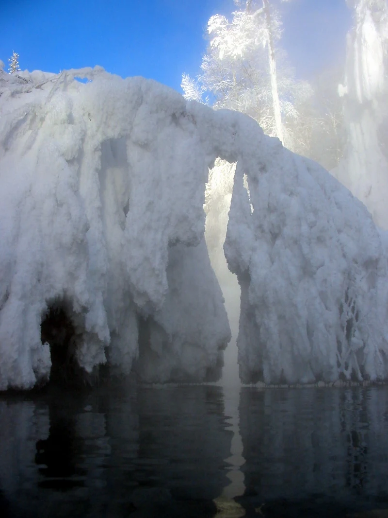
A natural hot spring pool in winter with heavy ice and snow formations hanging over the water, creating a steam-filled gap against a clear blue sky.
The thermal waters of Liard River Hot Springs surrounded by winter ice.

Liard River Hot Springs Provincial Park history and protected-area timeline

Liard River Hot Springs Provincial Park was formally established in April 1957, though human use of the hot springs long predates this designation. Early access infrastructure was developed in 1942, when the United States Army constructed the first boardwalk and basic pool facilities during the construction era of the Alaska Highway. This early built environment laid the foundation for the park's current system of raised walkways and bathing access points that allow visitors to reach the springs while protecting the fragile surrounding muskeg.

The hot springs were originally known as the Theresa Hot Springs, a name that reflects an earlier chapter in the site's identity before its current designation. The springs themselves remained a local curiosity and travel waypoint through the mid-twentieth century, and the area's botanical richness earn it the informal nickname the "Tropical Valley" among travelers. The park's inclusion within the broader Muskwa-Kechika Management Area added a larger conservation framework to the site, anchoring its significance within a landscape-level approach to northern wilderness.

Liard River Hot Springs Provincial Park landscape and geographic character

The landscape of Liard River Hot Springs Provincial Park is defined by the meeting of boreal forest with geothermal water. The terrain features boreal woodland, muskeg wetland, and river flats, with the warm-water swamp forming a central ecological and visual feature. The hot spring discharge keeps portions of the valley milder and more humid than the surrounding region, producing a microtopography of warm pools, slow-moving channels, lush vegetation, and contrasting cooler forest.

Muskeg, the wet, spongy peatland characteristic of northern Canada, surrounds much of the approach to the springs. To protect this delicate ground, the park uses a roughly 700-metre raised wooden walkway that crosses picturesque muskeg between the parking area and the Alpha Pool. Waterfalls from the Alpha Pool form one of the signature scenic elements, with cascades tumbling amid dense vegetation. The overall impression is of an unusual sheltered valley within a broader boreal landscape, shaped by heat rising from the earth rather than by elevation or latitude.
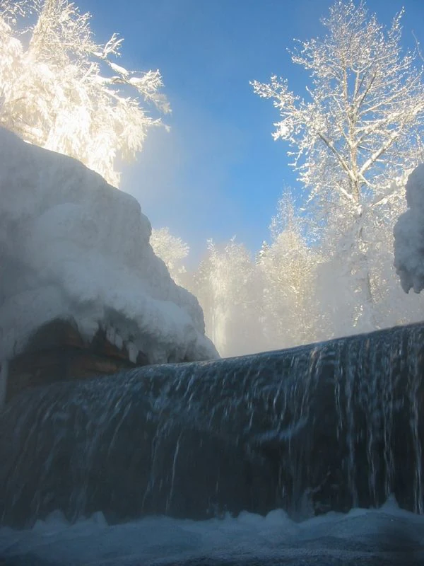
A low-angle view of a small thermal waterfall cascading over a ledge, surrounded by snow-covered trees and heavy frost in a winter forest.
Winter view of the thermal waters at Liard River Hot Springs.

Liard River Hot Springs Provincial Park ecosystems, habitats, and plant life

The park's natural character arises from the unusual coexistence of two very different ecosystems in one small area. Outside the warm influence of the springs, the surrounding terrain is typical northern boreal forest, dominated by conifers and adapted to long winters. Within the influence zone of the hot spring discharge, however, vegetation shifts toward lush, herbaceous, and moisture-loving communities that include rare orchids. Fourteen orchid species have been documented in the park, an unusually high diversity for this latitude.

The warm-water swamp functions as both an ecological and thermal anomaly. Constant heat and humidity create conditions that allow a wider range of plants to thrive, including species more commonly associated with much milder climates. This microclimate supports the mammal and bird populations that find food and shelter here, particularly moose, which feed on the rich aquatic and emergent vegetation of the swamp. The result is a small but ecologically concentrated area where habitat diversity exceeds what the surrounding boreal landscape alone could support.

Liard River Hot Springs Provincial Park wildlife and species highlights

Wildlife observation is a major component of the Liard River Hot Springs experience. Moose are frequently seen feeding in the warm-water swamps, where the warmer conditions and rich aquatic vegetation create favorable browsing habitat. Black bears are also common, particularly in the warmer months, and may sometimes approach closely to visitors around the springs. The combination of predictable water, food resources, and cover makes the springs area a natural concentration point for local fauna.

Birds and small mammals benefit similarly from the warm microclimate, taking advantage of the milder conditions and abundant plant life near the springs. The park's position within the broader Muskwa-Kechika Management Area places it inside a wildlife-rich northern landscape that supports wide-ranging species such as caribou, wolves, and bears across the wider region. Within the park itself, the springs corridor is the most reliable area for close wildlife encounters.

Liard River Hot Springs Provincial Park conservation status and protection priorities

Liard River Hot Springs Provincial Park holds conservation significance for several reasons. Its geothermal springs and the associated warm-water swamp represent a rare natural feature within the boreal forest of northern British Columbia, and the park's designation as an IUCN Category III protected area recognizes its status as a notable natural monument. The fragile muskeg surrounding the springs is highly sensitive to disturbance, and the park's design, particularly its raised walkway system, reflects an effort to protect this substrate while still allowing public access.

The park is also part of the much larger Muskwa-Kechika Management Area, a landscape-scale conservation framework intended to maintain the ecological integrity of one of the largest intact wilderness areas in North America. This broader context gives the park significance beyond its own small footprint, connecting it to a wider effort to preserve northern wilderness character, large-movement mammal habitat, and ecological processes across an extensive region of central and northern British Columbia.

Liard River Hot Springs Provincial Park cultural meaning and human context

The hot springs site carries two distinct layers of informal cultural identity. Earlier travelers and local communities knew the springs as Theresa Hot Springs, a name that persisted in some references prior to and beyond the park's establishment. The second cultural layer is more informal and experiential: the nickname "Tropical Valley," earn by travelers overcome by the lush, orchid-rich plant life sustained by the geothermal warmth. Together, these names reflect a long tradition of the springs functioning not just as a geographic curiosity but as a memorable stop along northern travel routes.

Top sights and standout views in Liard River Hot Springs Provincial Park

Liard River Hot Springs Provincial Park stands out for the rarity of its natural hot spring river system within a boreal environment. The Alpha Pool, the park's central feature, offers warm-water bathing amid northern forest and muskeg. A 700-metre raised walkway leads through picturesque muskeg and past waterfalls from the Alpha Pool, combining functional infrastructure with scenic access. The surrounding warm-water swamp supports moose, bears, and orchid-rich plant communities, making the park a concentrated point of biodiversity within an otherwise cold northern landscape.

Best time to visit Liard River Hot Springs Provincial Park

Summer is the most practical and popular period to visit Liard River Hot Springs Provincial Park, when the Alaska Highway corridor is reliably accessible and warm temperatures make the contrast between hot spring water and the boreal landscape most enjoyable. Summer is also when bears and moose are most active around the warm-water swamp, increasing the chance of wildlife encounters. The lush, orchid-rich vegetation that earn the area its "Tropical Valley" reputation is most visible in the warmer months, when humidity and plant growth are at their peak.
Monthly climate preview

Long-term temperature and precipitation records measured across twelve representative months

Liard River Hot Springs Provincial Park Climate Normals and Weather by Month

Liard River Hot Springs Provincial Park records long-term monthly temperatures ranging from severe winter lows to warm summer maximums alongside varying daily precipitation rates. Examining the full twelve-month profile provides complete historical averages for evaluating regional climate patterns at this representative coordinate.
Annual mean-3 °C
-18 °C13 °C
Jan-18°
Feb-15°
Mar-12°
Apr-3°
May
Jun11°
Jul13°
Aug11°
Sep
Oct-2°
Nov-12°
Dec-16°
Warmest month
July

12.6 °C

Coolest month
January

-17.8 °C

Wettest month
July

3.5 mm/day

Driest month
February

1.2 mm/day

Park location guide

Geography guide, regional context, and park location map for Liard River Hot Springs Provincial Park

Liard River Hot Springs Provincial Park park geography, regions, and map view in Canada

Understand where Liard River Hot Springs Provincial Park sits in Canada through a broader geographic reading of the surrounding landscape, nearby location context, and its mapped position within the national park landscape.

How Liard River Hot Springs Provincial Park fits into Canada

Canada is a federal parliamentary constitutional monarchy spanning North America from the Atlantic to the Pacific and Arctic Oceans. With a population of over 41 million, it is officially bilingual in English and French at the federal level. The country gained independence from the United Kingdom through a gradual process culminating in 1982.

Wider geography shaping Liard River Hot Springs Provincial Park in Canada

Canada occupies the northern portion of North America, sharing its longest international border with the United States. The country extends from the Atlantic Ocean to the Pacific Ocean and northward into the Arctic Ocean, giving it the longest coastline of any nation.

Map view of Liard River Hot Springs Provincial Park

Use this park location map to pinpoint Liard River Hot Springs Provincial Park in Canada, understand its exact geographic position, and read its mapped placement within the surrounding landscape more clearly.

Pigeon | © OpenStreetMap contributors

Location context for Liard River Hot Springs Provincial Park

British Columbia

Visual reference guide to northern boreal forest, geothermal pools, and muskeg wetland habitats

Liard River Hot Springs Provincial Park Photos and Protected Landscape Scenery

Visual documentation captures the unique convergence of geothermal warmth and northern boreal forest defining Liard River Hot Springs Provincial Park. Photographic records illustrate mineral thermal pools, raised boardwalks across muskeg wetlands, and lush sheltered vegetation.

A natural hot spring pool in winter with heavy ice and snow formations hanging over the water, creating a steam-filled gap against a clear blue sky.

A natural thermal pool with steam rising from the surface, flanked by a wooden boardwalk and surrounded by dense boreal forest.

A low-angle view of a small thermal waterfall cascading over a ledge, surrounded by snow-covered trees and heavy frost in a winter forest.

Park atlas

Compare nearby northern wilderness reserves, boreal forest tracts, and regional protected landscapes.

Other Parks Near Liard River Hot Springs Provincial Park and Surrounding Protected Areas

Browsing other parks near Liard River Hot Springs Provincial Park reveals a wider network of northern wilderness reserves and boreal forest tracts. Comparing these adjacent protected areas provides essential regional context on northern British Columbia ecosystems.
State or regional parkBritish Columbia
About 83 km away#1 closest

Southwest

Horneline Creek Provincial Park: Protected Canyon Landscapes and Rocky Mountain Trench Geography

Remote glacial-terrace wilderness in northern British Columbia

Located deep in the Rocky Mountain Trench, Horneline Creek Provincial Park is defined by its deep-cut canyon and ancient glacial terraces. This protected area offers an intimate view of sub-boreal terrain where mineral-stained walls and aspen-dotted grasslands create a concentrated, ecologically significant landscape within a remote corner of northern British Columbia.

Area
2.98 km²
Established
1999
IUCN
II
Relief
Upland
State or regional parkBritish Columbia
About 94 km away#2 closest

Southwest

Denetiah Provincial Park and Protected Area: Regional Geography and Wilderness Mapping

An undisturbed boreal reserve in the Stikine Region

Discover the geographic structure of Denetiah Provincial Park and Protected Area, a vast roadless landscape in northern British Columbia. This park protects pristine boreal forests, elongated glacial lake basins, and critical river headwaters that serve as a benchmark for northern conservation within the Muskwa-Kechika Management Area.

Area
1,053.49 km²
Established
1999
IUCN
II
Relief
Upland
State or regional parkBritish Columbia
About 115 km away#3 closest

South

Dune Za Keyih Provincial Park and Protected Area: Watershed and Terrain Geography

Remote wilderness landscape in northern British Columbia

Dune Za Keyih Provincial Park and Protected Area protects the largest unlogged watershed in British Columbia. Situated within the Muskwa-Kechika Management Area, this remote wilderness is defined by the geological structures of the Rocky Mountain Trench, providing a continuous corridor of undisturbed mountain forest, riparian zones, and highland terrain.

Area
3,468.33 km²
Established
2001
IUCN
Ib
Relief
Mountain
National parkNorthwest Territories
About 151 km away#4 closest

North

Nahanni National Park Reserve National Park: Protected Landscape and Geographic Mapping

Explore the mapped terrain and protected area boundaries in Northwest Territories.

Navigate the protected landscape of Nahanni National Park Reserve, a designated national park within the Northwest Territories. This entry provides detailed insight into the park's mapped geographic boundaries and its role as a significant protected area. Understanding its place within the regional atlas allows for a deeper appreciation of its natural terrain and conservation significance, offering factual context for geographic exploration.

Area
30,050 km²
Established
1972
IUCN
II
Visitors
1.1K annual
State or regional parkBritish Columbia
About 158 km away#5 closest

East

Jackpine Remnant Provincial Park: Protected Boreal Landscape and Regional Map Context

Conservation and terrain data for the Fort Nelson region

Jackpine Remnant Provincial Park provides a critical study in northern conservation geography. Located in the Fort Nelson area of British Columbia, this 148-hectare site protects a rare stand of jack pine trees. Its mapped boundaries and boreal forest terrain offer a focused look at small-scale protected landscapes and their significance within the broader regional ecosystem of the Canadian north.

Area
1.48 km²
Established
2001
IUCN
II
Relief
Lowland
State or regional parkBritish Columbia
About 165 km away#6 closest

South

Kwadacha Wilderness Provincial Park: Geographic Boundaries and Regional Protected Area Context

Untouched mountain wilderness in northern British Columbia

Kwadacha Wilderness Provincial Park provides a rare, roadless mountain experience within the northeastern interior of British Columbia. Characterized by high-relief alpine ridges, dense boreal forests, and challenging river systems, the park represents an essential wilderness corridor that remains free from human infrastructure and standard road access, prioritizing ecological integrity over recreation.

Area
1,302.79 km²
Established
1973
IUCN
Ib
Relief
Mountain
State or regional parkBritish Columbia
About 165 km away#7 closest

East

Maxhamish Lake Provincial Park and Protected Area: Mapping Northern British Columbia Wilderness

Boreal lake ecosystems and protected indigenous heritage lands

Spanning over 27,500 hectares, Maxhamish Lake Provincial Park and Protected Area is a remote boreal refuge characterized by its central lake and extensive coniferous forests. This park provides a critical habitat for moose, deer, and cold-water fish species while maintaining deep ties to the Fort Nelson First Nation and Acho Dene Koe. Its geography reveals a distinct northern basin, offering insight into the ecological character and protected landscape features of northeastern British Columbia.

Area
275.16 km²
IUCN
II
Water
Major water bodies
Season
Seasonal
State or regional parkBritish Columbia
About 209 km away#8 closest

South

Finlay-Russel Provincial Park and Protected Area: Mapping Northern British Columbia Wilderness

A remote river corridor in the Muskwa-Kechika Management Area.

Located in northern British Columbia, Finlay-Russel Provincial Park and Protected Area preserves an essential 85-kilometre river corridor along the Finlay River. This expansive wilderness territory serves as an integral part of the Muskwa-Kechika Management Area, showcasing deep boreal forest landscapes and rugged river valley terrain far from established road networks.

Area
1,092.05 km²
Established
2001
IUCN
II
Access
Remote access

Common questions about visiting, size, designation, and location context for Liard River Hot Springs Provincial Park

Liard River Hot Springs Provincial Park FAQs for park facts, access, geography, and protected area context

Find quick answers about Liard River Hot Springs Provincial Park, including protected-area facts, park geography, trail and visitor context, and how the park fits into its surrounding country and regional landscape.
MoriAtlas Explorer

Continue Your Protected Areas Search Across the Global Atlas

Deepen your exploration by continuing the structured search for national parks and protected areas worldwide. Utilize the comprehensive filtering capabilities to compare different conservation landscapes and refine your understanding of global park geography. Discover more about the distribution and characteristics of protected natural areas.

Global natural geography