Mori Atlas logo
Nature reserveLimberg und Offelter Berg

Mapping the geographic terrain and forest habitats of the eastern Wiehen Hills ridge

Limberg und Offelter Berg: A Historic Nature Reserve and Protected Woodland in North Rhine-Westphalia

(Naturschutzgebiet Limberg und Offelter Berg)

Limberg und Offelter Berg represents a significant protected landscape at the eastern edge of the Wiehen Hills in North Rhine-Westphalia, Germany. Spanning approximately 186 hectares, this nature reserve preserves a mosaic of near-natural Waldmeister beech forests, spring-fed headwaters of the Landwehrbach, and diverse woodland habitats. Established in 1935, the site serves as a vital ecological reference point within the Minden-Lübbecke district, illustrating the long-term conservation of native Westphalian forest terrain.

beech forestwoodland reservenature reserveNaturschutzgebietWiehengebirge foothillsheadwater streams

Limberg und Offelter Berg

Nature reserve

Park overview

Structured park overview, official facts, and landscape profile for Limberg und Offelter Berg

Limberg und Offelter Berg park facts, protected area profile, and essential visitor context

Review the core facts for Limberg und Offelter Berg, including designation, size, terrain, visitor scale, habitats, and operating context in one park-focused overview.

About Limberg und Offelter Berg

Limberg und Offelter Berg is one of the long-established forest nature reserves of the eastern Wiehen Hills. Its roughly 186 hectares wrap around two namesake hills, the Limberg and the Offelter Berg, on the outermost eastern ridge of the Egge, a smaller side ridge that branches off from the main Wiehengebirge range. The reserve lies inside the municipal area of Preußisch Oldendorf in the Minden-Lübbecke district of North Rhine-Westphalia, and its boundaries effectively surround the built-up areas of the Preußisch Oldendorf town center, the village of Offelten to the north, Bad Holzhausen to the east, and Börninghausen to the south.

The site's protected character derives from its forest communities, which include extensive stands of Waldmeister-Buchenwald, a near-natural type of beech woodland named for the woodruff (Waldmeister) species in its understory. These beech forests carry a particularly rich herb layer, which is one of the main reasons the area received protection. In addition to the dominant beech forests, the reserve conserves Hainsimsen beech woodland on more acidic soils, mixed maple and ash slope forest on steeper terrain, and smaller open habitats including reed beds, traditional orcharding meadows (Obstwiesen), and tall-herb communities along forest edges and clearings.

Hydrologically, the area is significant because the headwaters of the Landwehrbach, a tributary of the Große Aue, rise within the reserve. The spring areas and upper reaches of this small stream are part of the protected landscape, reinforcing the site's role as both a forest island and a source of clean water in an otherwise heavily used rural region. The combination of forest cover, slope, and spring seepage creates the shaded, moist conditions that support the reserve's more specialized woodland plant communities.

Although small compared with Germany's larger national parks, Limberg und Offelter Berg carries considerable local weight. It has been a legally protected nature reserve since 1935, predating most other designations in the district and many in Westphalia, and remains an anchor site in the constellation of protected areas around the former Altkreis Lübbecke. For visitors interested in the regional forest heritage of eastern Westphalia, it represents one of the most authentic surviving fragments of traditional, structurally rich beech forest in the Wiehen foothills.

Quick facts and research context for Limberg und Offelter Berg

Limberg und Offelter Berg lies within the town of Preußisch Oldendorf in the Minden-Lübbecke district of North Rhine-Westphalia, on the eastern end of the Egge, a secondary ridge of the Wiehen Hills. The reserve carries the official designation MI-027 and covers about 186 hectares, surrounding the villages of Preußisch Oldendorf, Offelten, Bad Holzhausen, and Börninghausen.

It was established in 1935 as the oldest nature reserve in the Minden-Lübbecke district and one of the oldest in Westphalia. The protected forests, headwater streams, and small open habitat patches form part of the Lübbecker Eggen natural area and are managed primarily to conserve rare woodland ecosystems and to serve as a refuge for threatened native species.

Protection and recognition

Terrestrial conservation framework and verified administrative recognition details

Limberg und Offelter Berg Protection Status and Designated Area Record

Limberg und Offelter Berg holds a documented terrestrial protection scope within the regional conservation inventory. Official records compile management classifications, designation history, and international recognition data for comprehensive habitat analysis.

Protection details

Protection scope
Terrestrial
Park context

Deeper park guide and search-rich context for Limberg und Offelter Berg

Limberg und Offelter Berg history, landscape, wildlife, and travel context

Explore Limberg und Offelter Berg through its history, landscape character, ecosystems, wildlife, conservation priorities, cultural context, and seasonal travel timing in a structured park guide built for atlas discovery and search intent.

Why Limberg und Offelter Berg stands out

Limberg und Offelter Berg is best known for its near-natural Waldmeister beech forest (woodruff beech woodland) on the slopes of the Limberg and Offelter Berg, with a diverse herb layer, spring-fed headwaters, and a mosaic of associated woodland communities. The site's age as a protected area, dating back to 1935, also gives it a place of honor in the regional conservation history of eastern Westphalia.
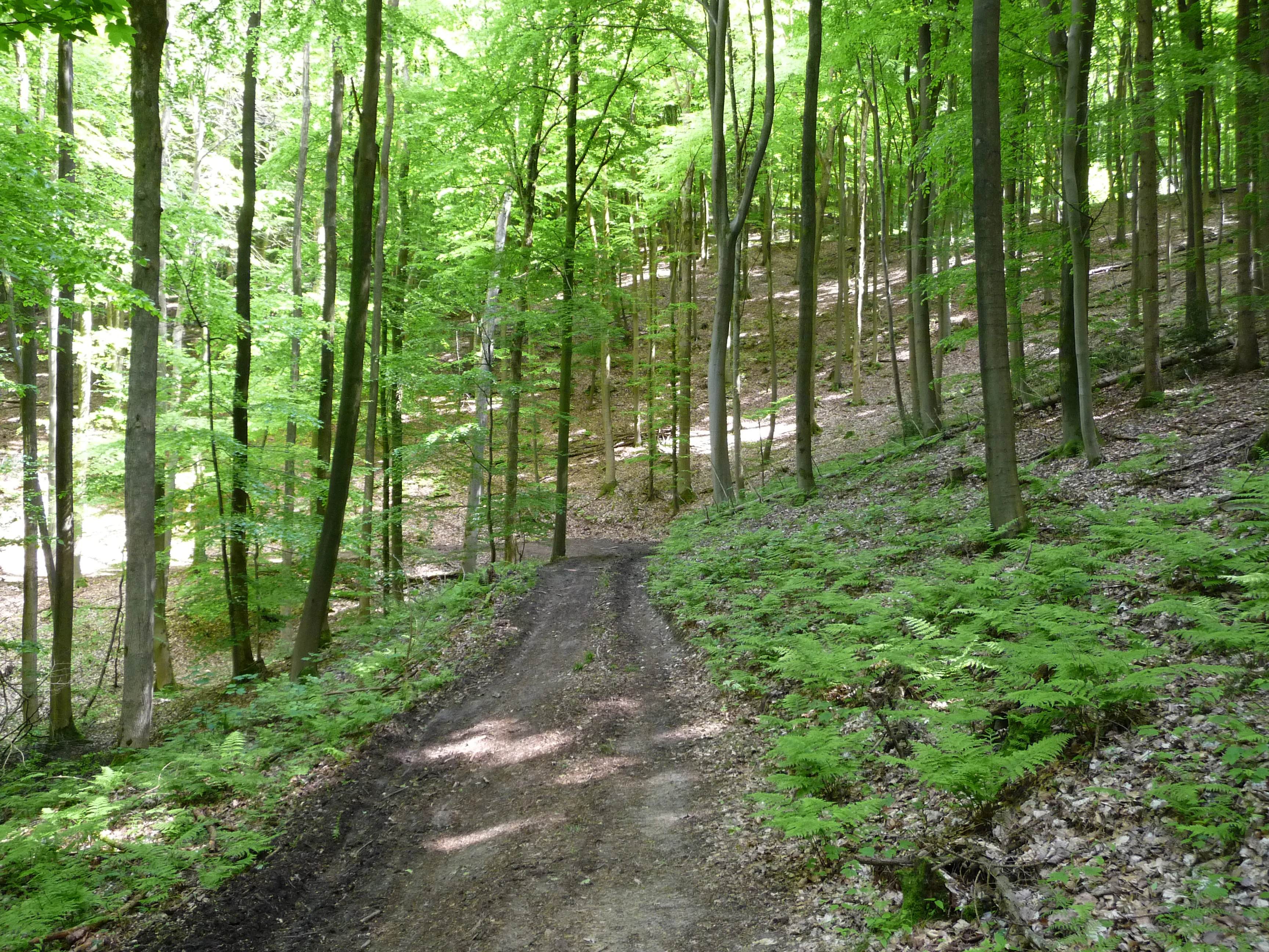
A dirt trail leads uphill through a dense, bright green deciduous forest with ferns on the forest floor.
A dirt path winding through the lush, green beech forests of the Limberg und Offelter Berg nature reserve.

Limberg und Offelter Berg history and protected-area timeline

The nature reserve Limberg und Offelter Berg was officially designated in 1935, making it the oldest protected area in the Minden-Lübbecke district and one of the earliest nature reserves in Westphalia. The early date of protection reflects an early recognition in the region of the scientific and conservation value of the woodland on these two hills and the spring-fed valleys between them.

The justification given at the time of designation, and carried forward in later descriptions of the area, centered on the rarity and particular character of the site, and on the role of the forest as a refuge (Refugium) for threatened wild plants and animals. Later conservation documents continued to frame the reserve in these terms, emphasizing the need to maintain and, where necessary, restore characteristic woodland communities such as the Waldmeister beech forest, slope woodland, and associated small open habitats.

Although the broader administrative and regional framework around the reserve has shifted over the decades, the protected status itself has been continuously maintained. The reserve is currently managed under the North Rhine-Westphalia state nature conservation system and is recorded in the official Fachinformationssystem of the Landesamt für Natur, Umwelt und Klima Nordrhein-Westfalen (LANUK) under the code MI-027, confirming its status as one of the enduring pillars of regional nature conservation in the former Lübbecke district area.

Limberg und Offelter Berg landscape and geographic character

The landscape of Limberg und Offelter Berg is shaped by the eastern end of the Egge, a secondary ridge of the Wiehen Hills. The two hills that give the reserve its name, the Limberg and the Offelter Berg, form the most prominent relief features, with their slopes and the saddle between them making up the core of the protected area. The terrain consists of low, rounded hilltops and broader, often steeply descending slopes cut by small stream valleys.

Because the reserve sits on the outermost eastern tip of the ridge system, it transitions gradually into the surrounding lowlands of the Lübbecke basin. This transitional position gives the site a characteristic mix of montane forest conditions on the upper slopes and more lowland-influenced habitats in the valley bottoms. The springs at the foot of the hills feed the headwaters of the Landwehrbach, which begins its course within the protected area before flowing out toward the Große Aue river system further east.

The result is a compact but varied landscape: closed beech forest canopy over much of the hills, interspersed with smaller forest communities on steeper or wetter ground, and a fringe of meadows, orcharding land, and reed beds where the woodland gives way to surrounding villages and farmland.

Limberg und Offelter Berg ecosystems, habitats, and plant life

Ecologically, the reserve is dominated by beech forest, and the most important woodland type is the Waldmeister-Buchenwald, a near-natural beech forest community of the kind found across central European uplands. This community is characterized by a tall beech canopy, a relatively open interior, and a herb layer rich in characteristic species such as woodruff and related woodland herbs. The herb layer diversity is one of the key reasons the forest qualified for early protection.

Alongside the woodruff beech forest, the reserve protects Hainsimsen-Buchenwald, a more acid-tolerant beech woodland type typically found on less base-rich soils, as well as mixed Ahorn-Eschen-Hangwald, a slope forest dominated by sycamore maple and ash, which occupies the steeper and more dynamic parts of the hillsides. These forest types together form a relatively complete representation of native woodland communities for the local geological conditions.

In the moister and more open parts of the area, the reserve preserves smaller-scale habitats including reed beds (Röhrichte), traditional orcharding meadows (Streuobstwiesen), and tall-herb communities (Hochstaudenfluren), which add structural diversity and support different groups of species than the closed forest. The combination of woodland, spring seepage, and these open patches gives the site a layered ecological character unusual for its modest size.

Limberg und Offelter Berg conservation status and protection priorities

The conservation significance of Limberg und Offelter Berg rests on the combination of its ecological character and its long-standing protected status. The original 1935 designation was explicitly motivated by the rarity and special character of the area, and by its function as a refuge for threatened wild plant and animal species. More than eighty years later, the reserve continues to be valued for the same reasons: the site supports near-natural woodland communities and associated habitats that have largely disappeared from the surrounding agricultural and settled landscape.

The reserve is part of the Lübbecker Eggen natural area, a regional landscape unit that connects the protected forests, meadows, and headwater streams of the eastern Wiehen foothills. Within this framework, Limberg und Offelter Berg serves as a core woodland refuge, complementing nearby reserves focused on moors, marshland, and open wetland habitats. Together these sites maintain a network of small, ecologically distinct protected areas across the former Altkreis Lübbecke.

Modern management continues to emphasize the preservation and, where necessary, restoration of characteristic forest communities, including the dominant woodruff beech forest, related beech woodland types, slope woodland, and the smaller reed bed, orcharding meadow, and tall-herb habitats. The headwaters of the Landwehrbach within the reserve are also protected, adding a hydrological and water-quality dimension to the site's conservation value.

Top sights and standout views in Limberg und Offelter Berg

Among the most distinctive features of Limberg und Offelter Berg are its extensive Waldmeister beech forests with a notably species-rich herb layer, its position on the eastern Egge ridge at the edge of the Wiehen Hills, and the protected headwaters of the Landwehrbach that emerge from its slopes. The mosaic of woodland communities, including Hainsimsen beech forest and sycamore-ash slope forest, combined with smaller areas of reed beds, orcharding meadows, and tall-herb vegetation, creates an unusually complete sample of native habitats for such a compact site.

Equally important is the reserve's historical role. As the oldest nature reserve in the Minden-Lübbecke district and one of the oldest in Westphalia, designated in 1935, it stands as a foundational site for regional nature conservation and a long-term reference point for understanding how eastern Westphalian beech forests have been protected through more than eight decades of changing landscapes and policies.

Monthly climate preview

Long-term monthly temperature averages and precipitation patterns for Limberg und Offelter Berg

Limberg und Offelter Berg Climate Normals and Annual Temperature Rhythm

Representative coordinate records show measured monthly temperature ranges alongside consistent daily precipitation patterns across the year. Reviewing the complete twelve-month normals provides deeper analytical insight into local climate variations at the sampled elevation.
Annual mean9 °C
1 °C18 °C
Jan
Feb
Mar
Apr
May13°
Jun16°
Jul18°
Aug18°
Sep14°
Oct10°
Nov
Dec
Warmest month
July

18.5 °C

Coolest month
January

0.9 °C

Wettest month
July

2.3 mm/day

Driest month
April

1.4 mm/day

Park location guide

Geography guide, regional context, and park location map for Limberg und Offelter Berg

Limberg und Offelter Berg park geography, regions, and map view in Germany

Understand where Limberg und Offelter Berg sits in Germany through a broader geographic reading of the surrounding landscape, nearby location context, and its mapped position within the national park landscape.

How Limberg und Offelter Berg fits into Germany

Germany is a federal republic in Western and Central Europe with a population of over 83 million across sixteen constituent states. It is Europe's largest economy by nominal GDP and a major global exporter and importer. The capital is Berlin, and the country borders Denmark, Poland, Czech Republic, Austria, Switzerland, France, Luxembourg, Belgium, and the Netherlands.

Wider geography shaping Limberg und Offelter Berg in Germany

Germany is located in Western and Central Europe, spanning 357,022 km². It borders Denmark to the north, Poland and the Czech Republic to the east, Austria and Switzerland to the south, and France, Luxembourg, Belgium, and the Netherlands to the west. The country has coastlines on the Baltic Sea and North Sea to the north, with the Alps located in the southern region.

Map view of Limberg und Offelter Berg

Use this park location map to pinpoint Limberg und Offelter Berg in Germany, understand its exact geographic position, and read its mapped placement within the surrounding landscape more clearly.

Pigeon | © OpenStreetMap contributors

Location context for Limberg und Offelter Berg

North Rhine-Westphalia

Visualizing protected forest habitats, beech woodlands, and regional terrain

Limberg und Offelter Berg Photos and Landscape Scenery

Examine detailed visual records of Limberg und Offelter Berg to observe native beech forests, spring-fed stream valleys, and sloping hill topography. Photographic evidence clarifies the protected landscape character and natural habitat diversity spanning the eastern Wiehen Hills ridge.

A dirt trail leads uphill through a dense, bright green deciduous forest with ferns on the forest floor.

Park atlas

Compare adjacent forest reserves and regional conservation areas across the Wiehen Hills

Explore Parks Near Limberg und Offelter Berg and Surrounding Protected Landscapes

Visitors exploring Limberg und Offelter Berg can continue browsing nearby protected areas and connected woodland reserves across the eastern Westphalia region. Comparing adjacent terrain helps reveal how local beech forests and ridge habitats fit into the wider regional conservation network.
A wide watercolor illustration showing a green landscape with a winding white path or stream, pink blossoming trees, and distant purple mountains under a pale sky.
Nature reserveNorth Rhine-Westphalia
About 6.7 km away#1 closest

Southwest

Kilverbachtal Nature Reserve: Protected Valley Geography in North Rhine-Westphalia

A refined look at lowland stream morphology and regional riparian habitats.

Kilverbachtal preserves a rare example of a narrow, box-shaped stream valley known as a Siek. This protected landscape features a mosaic of wet meadows, alder-lined riparian zones, and forested slopes that cut through the agricultural terrain of North Rhine-Westphalia. The area acts as a vital refugium for specialized flora and fauna, providing deep insight into the regional natural heritage and geological character of northwestern Germany.

Area
1.07 km²
Relief
Lowland
Climate
Temperate
Access
Access unknown
A horizontal watercolor illustration featuring a stylized forest with shades of green and yellow trees against a backdrop of soft, faint hills.
Nature reserveNorth Rhine-Westphalia
About 6.9 km away#2 closest

East

Sonnenwinkel Nature Reserve: Protected Landscape and Forest Ecology in North Rhine-Westphalia

Calcareous beech forest and seasonal woodland habitats

Sonnenwinkel is a dedicated nature reserve near Lübbecke, North Rhine-Westphalia, providing a critical refugium for calcareous beech forest. The site exhibits distinct ecological boundaries defined by the Wiehengebirge foothills and remains a significant example of protected lowland forest habitat in Germany.

Area
0.047 km²
Relief
Mountain
Climate
Temperate
Access
Easy access
Nature reserveNorth Rhine-Westphalia
About 22 km away#3 closest

Northeast

Mindenerwald Protected Nature Reserve: Geography, Boundaries, and Forest Terrain

A vital deciduous woodland complex in northern North Rhine-Westphalia.

The Mindenerwald nature reserve represents a substantial forest tract characterized by sandy-soil oak woodlands and diverse ash-alder wetlands. This protected landscape serves as a critical node for habitat connectivity, hosting a complex mosaic of spring-fed marshes and mature trees that support important bird and bat species within the broader Minden-Lübbecke district.

Area
8 km²
Relief
Lowland
Scope
Terrestrial
Water
Minor water
A watercolor illustration of a calm stream flowing through a green valley with trees and gentle hills in the background.
Nature reserveNorth Rhine-Westphalia
About 24 km away#4 closest

Southeast

Naturschutzgebiet Mittelbach Nature Reserve: Mapped Protected Landscapes in Vlotho

Classic Siek stream valley geography and riparian woodland habitats

The Naturschutzgebiet Mittelbach is a protected area in eastern Westphalia that defines the local landscape with its deeply cut moisture-rich valley. This site serves as a vital reference for the traditional Ravensberger Siek morphology, preserving a compact ecological network of sedge communities, beech forest patches, and riparian alder stands along a two-kilometer stream stretch.

Area
0.341 km²
Established
1998
Relief
Upland
Climate
Temperate
Nature reserveLower Saxony
About 24 km away#5 closest

Northwest

Streithorst Nature Reserve: Alluvial Woodland and River Lowlands in Lower Saxony

Protected floodplain forest and riparian geography

Located in the Osnabrück district, Streithorst functions as a vital nature reserve representing the rare ash and elm alluvial forests of the Hunte valley. This site, originating from a historic manor park, offers a concentrated look at riparian stream dynamics and mature woodland habitats surrounded by the agricultural plains of Lower Saxony.

Area
0.069 km²
Established
1982
IUCN
IV
Watercolor painting of a rolling forested landscape with hills and a central water feature, stylized with soft green and peach tones.
Nature reserveNorth Rhine-Westphalia
About 25 km away#6 closest

Southwest

Johannisegge-Schornstein Nature Reserve: Protected Woodland and Ridge Terrain Atlas

Exploring the Teutoburg Forest ridge geography in North Rhine-Westphalia.

Johannisegge-Schornstein stands as a vital nature reserve in Borgholzhausen, characterized by its exposed beech stands and its position on the Teutoburg Forest ridge. The reserve offers a clear look at historic coppice woodland management and local watershed geography, stretching from the rocky Bönkersche Steinbruch quarry to the prominent Luisenturm lookout point.

Area
2.255 km²
Established
2001
IUCN
IV
Relief
Mountain
Watercolor painting of soft, rolling green hills and a gentle mountain silhouette against a pastel sunrise sky.
Nature reserveNordrhein-Westfalen
About 26 km away#7 closest

South

Knüll-Storkenberg Nature Reserve: Mapping the Protected Terrain of the Teutoburg Forest

A diverse protected landscape of forest, spring-fed valleys, and grassland

Knüll-Storkenberg stands as a protected nature reserve in Nordrhein-Westfalen, encompassing a range of habitats from beech forests to sedge-filled valley meadows. This area integrates an abandoned limestone quarry into its managed landscape, creating a varied microclimate that supports distinct plant and animal communities. Its geography is anchored by the Knüll and Storkenberg hills, connected by the Wiesental valley.

Area
0.789 km²
Established
2001
IUCN
IV
Watercolor painting of a green, rolling landscape with trees and soft hills, rendered in a minimalist, light-toned style on a white background.
Nature reserveNordrhein-Westfalen
About 26 km away#8 closest

Southeast

In der Masch Nature Reserve: Mapped Floodplain Geography in Nordrhein-Westfalen

Protected nature reserve with rare lowland meadow habitats.

In der Masch offers a focused look at protected lowland river-meadow terrain within Germany. This 23-hectare nature reserve in Nordrhein-Westfalen protects interconnected oat-grass grasslands, riparian wood fringes, and historical boundary markers, providing a distinct study in regional floodplain topography and habitat preservation.

Area
0.23 km²
Established
2002
IUCN
IV

Common questions about visiting, size, designation, and location context for Limberg und Offelter Berg

Limberg und Offelter Berg FAQs for park facts, access, geography, and protected area context

Find quick answers about Limberg und Offelter Berg, including protected-area facts, park geography, trail and visitor context, and how the park fits into its surrounding country and regional landscape.
MoriAtlas Explorer

Continue Your Protected Areas Search Across the Global Atlas

Deepen your exploration by continuing the structured search for national parks and protected areas worldwide. Utilize the comprehensive filtering capabilities to compare different conservation landscapes and refine your understanding of global park geography. Discover more about the distribution and characteristics of protected natural areas.

Global natural geography